First drill stop: John Klein in Yellowknife Bay, Site 6, Sol 166-271, January 23-May 12, 2013 |

  |
First drill stop: John Klein in Yellowknife Bay, Site 6, Sol 166-271, January 23-May 12, 2013 |
 Feb 7 2013, 11:32 AM Feb 7 2013, 11:32 AM
Post
#181
|
||
 Member  Group: Members Posts: 112 Joined: 20-August 12 From: Spain Member No.: 6597 |
My take on the Sol 180 drill:
The original size image can be found here: https://www.dropbox.com/s/5151rhkt159d66u/taladrosol180.jpg |
|
 |
 
|
|
|
Feb 7 2013, 11:32 AM
Post
#182
|
|
 Senior Member Group: Members Posts: 2428 Joined: 30-January 13 From: Penang, Malaysia. Member No.: 6853 |
QUOTE (xflare @ Feb 7 2013, 07:13 PM)  There's a lot of it......I wonder if they could use the scoop to get some of that material into the chimra and then into the rover rather than up through the drill..? I think the plan is to first drill a full depth hole, but not collect the tailings into CHIMRA, then if they consider that test OK and the tailings suitable for entry in CHIMRA, they will perform another series of drilling for collection, but that will be used to clean the drill, its sleeve and the tailings collection chambers inside CHIMRA of any contamination from earth and then the rest of the chambers of the remaining Regolith from the scooped samples taken at Rocknest. Only when they are happy with all that cleaning will they process samples for SAM and or CHEMIN 
|
|
|
|
|
Feb 7 2013, 12:44 PM
Post
#183
|
||
|
Senior Member Group: Members Posts: 2346 Joined: 7-December 12 Member No.: 6780 |
A Sol 180 example of the subtle MAHLI focus stacking mechanism, using 16 low-res images (size 130%):
|
|
|
|
|
|
|
Feb 7 2013, 01:36 PM
Post
#184
|
|
|
Senior Member Group: Members Posts: 2428 Joined: 30-January 13 From: Penang, Malaysia. Member No.: 6853 |
QUOTE (Gerald @ Feb 7 2013, 08:44 PM) A Sol 180 example of the subtle MAHLI focus stacking mechanism, using 16 low-res images (size 130%): Nice GIF Gerald! It's a pity that some of the tailings are still in the hole, or maybe we could have estimated the full depth of the hole using this method?
|
|
|
|
|
Feb 7 2013, 02:12 PM
Post
#185
|
|
|
Founder Group: Chairman Posts: 14432 Joined: 8-February 04 Member No.: 1 |
One could calculate the dpeth by the position of the shadow and the local solar time.
|
|
|
|
|
Feb 7 2013, 02:18 PM
Post
#186
|
|
|
Senior Member Group: Members Posts: 2511 Joined: 13-September 05 Member No.: 497 |
QUOTE (Ant103 @ Feb 7 2013, 04:01 AM) IMO, I think it's time to stop recording rocks pictures and take some images with a strong public impact... with half an earth year on Mars, and so few great pictures to deal with (to dream with if I dare say), except a lot of rock collections, I think it's sad. Wow. You having a bad day? It's hard to take images near dawn and sunset because of thermal and Chemcam sun-pointing constraints. The ops people have been very conservative about focus, exposure, and data volume and that's led to fewer sequences that take longer than I was expecting. That said, I think we've done pretty well considering, and your criticism is a bit over the top. I'd have thought that you, if anyone, would appreciate that. -------------------- Disclaimer: This post is based on public information only. Any opinions are my own.
|
|
|
|
|
Feb 7 2013, 02:37 PM
Post
#187
|
||
|
Solar System Cartographer Group: Members Posts: 10153 Joined: 5-April 05 From: Canada Member No.: 227 |
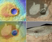
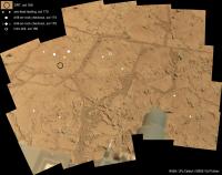
Here's the location of the new drill hole on the mosaic posted earlier by EdTruthan.
Phil
-------------------- ... because the Solar System ain't gonna map itself.
Also to be found posting similar content on https://mastodon.social/@PhilStooke Maps for download (free PD: https://upload.wikimedia.org/wikipedia/comm...Cartography.pdf NOTE: everything created by me which I post on UMSF is considered to be in the public domain (NOT CC, public domain) |
|
|
|
|
|
|
Feb 7 2013, 02:38 PM
Post
#188
|
||
|
Senior Member Group: Members Posts: 2346 Joined: 7-December 12 Member No.: 6780 |
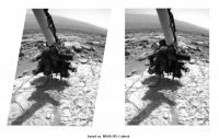
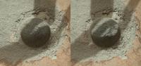
Sol 180 Front Hazcam before/after drill animated stereo gif:
|
|
|
|
|
|
|
Feb 7 2013, 03:28 PM
Post
#189
|
|||
 Senior Member Group: Members Posts: 4246 Joined: 17-January 05 Member No.: 152 |
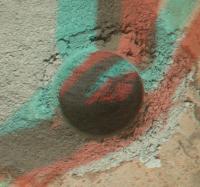
QUOTE (djellison @ Feb 7 2013, 03:12 PM) One could calculate the dpeth by the position of the shadow and the local solar time. Except, as Paul mentioned, we don't know how deep the tailings are in the hole, so any such estimate would be a lower limit. Another idea would be to estimate the depth of the tailings mound on the rim of the drill hole using MC imagery (when it's down). Then use the stereo imagery or depth map to scale to the (visible) bottom of the hole.Here's the MH view in stereo. Not perfect because of different shadows between the two frames:
|
||
|
|
|
||
|
Feb 7 2013, 03:44 PM
Post
#190
|
|
|
Senior Member Group: Members Posts: 4246 Joined: 17-January 05 Member No.: 152 |
QUOTE (Ant103 @ Feb 7 2013, 12:01 PM) with half an earth year on Mars, and so few great pictures to deal with (to dream with if I dare say), except a lot of rock collections, I think it's sad. If I may add to the OT, your own mosaics, Ant, prove your words wrong! And your latest 170/176 late afternoon mosaic is perhaps the best yet! The fact that there's a patch shot at different sun angle proves that this is not easy, like shooting panoramas from the Eiffel Tower would be. This is Mars. |
|
|
|
|
Feb 7 2013, 03:53 PM
Post
#191
|
||
 Member Group: Members Posts: 219 Joined: 14-November 11 From: Washington, DC Member No.: 6237 |
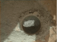
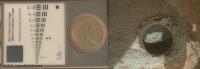
Here's a comparison of the hole to the calibration target/penny with both resized to the same scale (assumed hole = 16mm which is just larger than the 5/8-inch drill bit diameter; it could be a bit larger).
|
|
|
|
|
|
|
Feb 7 2013, 04:13 PM
Post
#192
|
|
|
Member Group: Members Posts: 112 Joined: 20-August 12 From: Spain Member No.: 6597 |
Maybe my math is wrong due to scale issues, but could the hole be 0.85 cm. (0.33 inches) deep?
I was using my own DEM to do this calculations. |
|
|
|
|
Feb 7 2013, 04:22 PM
Post
#193
|
|||
|
Member Group: Members Posts: 219 Joined: 14-November 11 From: Washington, DC Member No.: 6237 |
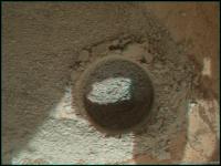
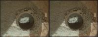
And here are 3D views (anaglyph/crosseye) of the first hole synthesized from MAHLI depthmap.
|
||
|
|
|
||
|
Feb 7 2013, 04:37 PM
Post
#194
|
|
 Member Group: Members Posts: 399 Joined: 28-August 07 From: San Francisco Member No.: 3511 |
From the status report this mini-drill test was to penetrate less than eight-tenths of an inch...
-------------------- 'She drove until the wheels fell off...'
|
|
|
|
|
Feb 7 2013, 04:53 PM
Post
#195
|
|
 Member Group: Members Posts: 150 Joined: 3-June 08 From: McLean, VA Member No.: 4177 |
QUOTE (Ant103 @ Feb 7 2013, 06:01 AM) IMO, I think it's time to stop recording rocks pictures and take some images with a strong public impact, like sunset (or -rise), at 100 mm and 34 mm, starfielfds, self-portrait of the Mast assembly in foreground of twilight or dawn, etc. Some pictures that could say to public : Curiosity IS on Mars, and she's doing amazing things here ! I want to be careful here... Damien, I feel your frustration. Personally I wish that all NASA programs had a deliberate policy of "pretty pictures", not by accident but by design. So you'd lose maybe one percent of your science time and go for the most telling, dramatic images you could design - your ideas are a good start. But I'm grateful that the MSL team shares what it does and that some of the participates are here commenting. I'm tremendously grateful that you and the others are doing such great stuff with what is out there. |
|
|
|
|

|
Lo-Fi Version | Time is now: 28th April 2024 - 03:26 PM |
|
RULES AND GUIDELINES Please read the Forum Rules and Guidelines before posting. IMAGE COPYRIGHT |
OPINIONS AND MODERATION Opinions expressed on UnmannedSpaceflight.com are those of the individual posters and do not necessarily reflect the opinions of UnmannedSpaceflight.com or The Planetary Society. The all-volunteer UnmannedSpaceflight.com moderation team is wholly independent of The Planetary Society. The Planetary Society has no influence over decisions made by the UnmannedSpaceflight.com moderators. |
SUPPORT THE FORUM Unmannedspaceflight.com is funded by the Planetary Society. Please consider supporting our work and many other projects by donating to the Society or becoming a member. |
|