First drill stop: John Klein in Yellowknife Bay, Site 6, Sol 166-271, January 23-May 12, 2013 |

  |
First drill stop: John Klein in Yellowknife Bay, Site 6, Sol 166-271, January 23-May 12, 2013 |
 Feb 7 2013, 06:56 PM Feb 7 2013, 06:56 PM
Post
#211
|
|
 Member  Group: Members Posts: 238 Joined: 15-January 13 Member No.: 6842 |
QUOTE (Eyesonmars @ Feb 7 2013, 06:07 PM)  Perhaps, but it is the atmospheric landscape type of shots with the topography fading into the haze, for instance, that get people's attention ( from my experience). And to be fair, many of the images called "pretty" do have some scientific value. One image I'm looking forward to will be taken when Curiosity is up a ways on the flank of Mt. Sharp gazing out at the horizon with Mt. Sharp and the rim of Gale crater rising up thru the fog. We know from orbital images that ground ice fogs are present at sunrise in low lying equatorial regions around aphelion. So it is not out of the question. There are plenty of Mastcam shots with the horizon and a bit of sky visible. But due to the dusty atmosphere, you can't see very far. You can just about make out the rim of the crater from Curiosity's location. I'm not a geologist of any kind, and even I find the martian terrain captivating. -------------------- Curiosity rover panoramas: http://www.facebook.com/CuriosityRoverPanoramas
My Photosynth panoramas: http://photosynth.net/userprofilepage.aspx...;content=Synths |
 |
 
|
|
Feb 7 2013, 06:58 PM
Post
#212
|
|
 Member Group: Members Posts: 112 Joined: 20-August 12 From: Spain Member No.: 6597 |
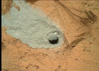
Now the dimensions of the hole are avaiable on Planetary Photojournal: http://photojournal.jpl.nasa.gov/catalog/PIA16761
It says the hole is 1.6 cm in diameter and 2 centimeters deep, but, maybe it's a perspective error, I think it's wider than deeper. Am I wrong? |
|
|
|
|
Feb 7 2013, 08:33 PM
Post
#213
|
|
 Senior Member Group: Members Posts: 4246 Joined: 17-January 05 Member No.: 152 |
It's possible that tailings in the hole make it look shallower than it was drilled.
But it's also possible that there's only a thin coating of tailings in the hole. Without knowing some engineering numbers we can't know how deep the hole is from these images. (As you said, the depth axis in your DEM is arbitrary units.) |
|
|
|
|
Feb 7 2013, 09:32 PM
Post
#214
|
|
|
Senior Member Group: Members Posts: 2346 Joined: 7-December 12 Member No.: 6780 |
Does someone know, whether the MAHLI motor count is available for one of the stacked images? Using the preliminary(?) motor count - focus depth map of one of the MAHLI papers might allow a good estimate for the depth axis scaling.
EDIT: I took the 5cm distance of the Photojournal, estimated the motor count to about 14500 from an available plot of the above map, estimated the motor count difference to about 400 from MAHLI depth image (about half the range of 16 images with respective motor count difference of about 50), meaning a motor count of about 14100 for the floor of the hole. The plot of the map is very close to 7cm working distance (for my eyes). So I regard a hole depth of about 2cm as consistent with results of this very preliminary method. |
|
|
|
|
Feb 7 2013, 10:50 PM
Post
#215
|
|
|
Senior Member Group: Members Posts: 4246 Joined: 17-January 05 Member No.: 152 |
Joe, are you able to extract the displacement between the two stereo MH frames:
http://mars.jpl.nasa.gov/msl-raw-images/ms...1001E1_DXXX.jpg http://mars.jpl.nasa.gov/msl-raw-images/ms...1000E1_DXXX.jpg Knowing the distance from mahli to the hole (since we know the hole diameter and MH fov), we could easily extract the depth of the hole from the parallax between the bottom and the rim. |
|
|
|
|
Feb 7 2013, 11:11 PM
Post
#216
|
||
 Senior Member Group: Members Posts: 2492 Joined: 15-January 05 From: center Italy Member No.: 150 |
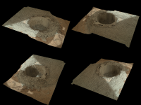
Four renderings of the drill-hole focus depth map, made with PovRay:
(each view is rotated by 90° around vertical axis) -------------------- I always think before posting! - Marco -
|
|
|
|
|
|
|
Feb 7 2013, 11:11 PM
Post
#217
|
||
|
Member Group: Members Posts: 808 Joined: 10-October 06 From: Maynard Mass USA Member No.: 1241 |
Here is the test hole. I combined two MAHLI images and warmed it up a bit.
Is there a mechanical reason for the preferred fallout pattern of the drill tailings? They all seem to drift to the upper left...
NEWS FLASH: Martian rocks are grey, all that red stuff is dust 
-------------------- CLA CLL
|
|
|
|
|
|
|
Feb 7 2013, 11:12 PM
Post
#218
|
|
|
Senior Member Group: Members Posts: 2346 Joined: 7-December 12 Member No.: 6780 |
From the hole diameter and the optical displacement, the absolute displacement should be close to 6mm, same pointing assumed. But the rim is higher than the surrounding plate.
EDIT: I get an expected parallaxe of about 2.4 mm, or 15% the hole diameter; something must be wrong with this. We have at least to add some unknown length to the working distance for a valid parallaxe calculation. |
|
|
|
|
Feb 8 2013, 12:04 AM
Post
#219
|
|
|
Founder Group: Chairman Posts: 14432 Joined: 8-February 04 Member No.: 1 |
So no one has tried taking the known diameter of the hole and the location of the shadow at the bottom in conjunction with the known local solar time to figure out the depth?
I'm travelling so can't bash out the numbers myself. It's not that hard though, surely. |
|
|
|
|
Feb 8 2013, 12:34 AM
Post
#220
|
||
 Member Group: Members Posts: 408 Joined: 3-August 05 Member No.: 453 |
Speaking of images of rocks
here is a fresh sol 179 Mastcam-34 pano:
The lower left rock is quite undercut and almost looks like it is floating when seen from different angles; I remember seeing it from the side before but for now the best one I can find is this partial side view from sol 162. Airbag [Edit: Ah, just noticed there is a set of matching full size MR images for this location too] |
|
|
|
|
|
|
Feb 8 2013, 01:27 AM
Post
#221
|
|
|
Senior Member Group: Members Posts: 2346 Joined: 7-December 12 Member No.: 6780 |
(EDIT: The following calculation is incomplete, because of Marsian obliquity of 25.2°!)
By the "shadow" method I get a lower bound of 19 mm from the floor to the rim: The image was taken at 12:47:11 P.M. LMST. That means about 12:45:00 P.M. LTST. An angle of 11.25° to 90°. MSL is 4.5° south. By Pythagoras I get an angle of 12.1° of the sun from zenith. The elevation of the hole is likely near 83.5° (90°-6.5°). Together a maximum angle of 18.6°. The shadow has a visually estimated length of about 6.4mm. Dividing 6.4mm by the tangens of 18.6° yields 19mm. Considering the bearing of the hole will yield a deeper hole. An assumed elevation of the hole of -90° yields about 30mm from the floor to the rim. |
|
|
|
|
Feb 8 2013, 03:08 AM
Post
#222
|
|
|
Junior Member Group: Members Posts: 87 Joined: 17-May 08 Member No.: 4114 |
In this gif http://photojournal.jpl.nasa.gov/catalog/PIA16762 the dust in the crevice around the block being drilled sinks quite noticeably. Neat.
Edit: link to photojournal page rather than gif |
|
|
|
|
Feb 8 2013, 03:32 AM
Post
#223
|
|
|
Member Group: Admin Posts: 976 Joined: 29-September 06 From: Pasadena, CA - USA Member No.: 1200 |
QUOTE (PDP8E @ Feb 7 2013, 03:11 PM) ... Is there a mechanical reason for the preferred fallout pattern of the drill tailings? They all seem to drift to the upper left... ... Hmmm... I think it is called gravity and I believe it is available on Mars ;-) I was confused as well until you look at the Mastcam instead of MAHLI. Paolo -------------------- Disclaimer: all opinions, ideas and information included here are my own,and should not be intended to represent opinion or policy of my employer.
|
|
|
|
|
Feb 8 2013, 03:36 AM
Post
#224
|
||
 Senior Member Group: Members Posts: 2428 Joined: 30-January 13 From: Penang, Malaysia. Member No.: 6853 |
QUOTE (PDP8E @ Feb 8 2013, 07:11 AM) Is there a mechanical reason for the preferred fallout pattern of the drill tailings? They all seem to drift to the upper left...
An animated GIF recently issued by JPL seems to answer that question for you. It indicates that the direction of the pattern for the tailings is caused by gravity due to the gentle incline of the bedrock towards the rover, this movement would have been greatly amplified by the percussive action of the drill. In addition to the tailings we can see some small pebbles and a quantity of dark fine particles on the same rock moving in the same direction. [Animated GIF released by JPL] |
|
|
|
|
|
|
Feb 8 2013, 04:16 AM
Post
#225
|
|
|
Member Group: Members Posts: 808 Joined: 10-October 06 From: Maynard Mass USA Member No.: 1241 |
QUOTE (RoverDriver @ Feb 7 2013, 11:32 PM) Hmmm... I think it is called gravity and I believe it is available on Mars ;-) I was confused as well until you look at the Mastcam instead of MAHLI. Paolo Hey Paolo, PaulH51, That's what I like about this place, ask a question, and get the answer. For the curious, Mars gravity is 3.71 m/s*s, while here on Earth it is 9.78 m/s*s So my 91 kg (~200 lb) mass would only weigh about 35 kg (~76 lb) on Mars! thanks for the NASA GIF link -------------------- CLA CLL
|
|
|
|
|

|
Lo-Fi Version | Time is now: 28th April 2024 - 05:11 PM |
|
RULES AND GUIDELINES Please read the Forum Rules and Guidelines before posting. IMAGE COPYRIGHT |
OPINIONS AND MODERATION Opinions expressed on UnmannedSpaceflight.com are those of the individual posters and do not necessarily reflect the opinions of UnmannedSpaceflight.com or The Planetary Society. The all-volunteer UnmannedSpaceflight.com moderation team is wholly independent of The Planetary Society. The Planetary Society has no influence over decisions made by the UnmannedSpaceflight.com moderators. |
SUPPORT THE FORUM Unmannedspaceflight.com is funded by the Planetary Society. Please consider supporting our work and many other projects by donating to the Society or becoming a member. |
|