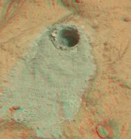
First drill stop: John Klein in Yellowknife Bay, Site 6, Sol 166-271, January 23-May 12, 2013 |

  |
First drill stop: John Klein in Yellowknife Bay, Site 6, Sol 166-271, January 23-May 12, 2013 |
 Feb 8 2013, 02:51 PM Feb 8 2013, 02:51 PM
Post
#241
|
|
 Member  Group: Members Posts: 219 Joined: 14-November 11 From: Washington, DC Member No.: 6237 |
QUOTE (jmknapp @ Feb 8 2013, 07:15 AM)  Is that right? I don't think so but to be sure I grabbed the NAVCAM pics and re-measured the distance using AlgorimancerPG. Confirmed distance is about 8.8-9 meters. Given the extent of about 50 pixels in the M-100 image, I continue to estimate it around 3.3 cm tall (say 3-4 cm to be safe). |
 |
 
|
|
Feb 8 2013, 03:26 PM
Post
#242
|
|
 Senior Member Group: Members Posts: 1465 Joined: 9-February 04 From: Columbus OH USA Member No.: 13 |
Someone made a wonderful 3D computer model of Curiosity, available for $15:
http://www.renderosity.com/mod/bcs/mars-ro...curiosity/95997 The one on TurboSquid is more detailed, but goes for $200: http://www.turbosquid.com/3d-models/3d-mar...er-model/685402 Could open up a chance for some cool visualizations, particularly if driven by actual rover NAV data. Here's a test animation I did with the renderosity model and Poser Pro 2010 animation software--a drilling sequence, apropos to this thread: http://www.youtube.com/watch?v=Z6zaToRu5bc -------------------- |
|
|
|
|
Feb 8 2013, 04:08 PM
Post
#243
|
|
 Senior Member Group: Members Posts: 4246 Joined: 17-January 05 Member No.: 152 |
QUOTE (Greenish @ Feb 8 2013, 03:51 PM) I continue to estimate it around 3.3 cm tall (say 3-4 cm to be safe). I made a crude check based on orbital imagery and agree, very roughly 9 m distance and roughly 3 cm tall (+/- 1 cm or so).QUOTE (jmknapp @ Feb 8 2013, 12:56 PM) FWIW, the sun elevation at the time of the MAHLI shots was 67.2 degrees. Taking FRA_413471035EDR_F0060000FHAZ00210M_ as reference for the drill orientation, I get an angle between the drill ("powder acquisition and drill system," MSL_PADS) vector and the sun vector at the time of the MAHLI shots of 27.2 degrees. So, if the MAHLI shot is more or less directly over the hole and the shadow is 6.5mm, then the depth is 6.5/tan(27.2) = 12.6 mm. Do I understand right that you've actually been able to extract the drill orientation during drilling from the engineering data, or is that an estimate based on the hazcam image? Why does the MH shot need to be directly overhead? We can see the full extent of the shadow.
|
|
|
|
|
Feb 8 2013, 04:19 PM
Post
#244
|
|
 Member Group: Members Posts: 112 Joined: 20-August 12 From: Spain Member No.: 6597 |
I agree with jmknapp about the depth of the hole. With the new MastCam images I get around 1.1-1.2 cm. deep.
|
|
|
|
|
Feb 8 2013, 04:21 PM
Post
#245
|
|
|
Senior Member Group: Members Posts: 1465 Joined: 9-February 04 From: Columbus OH USA Member No.: 13 |
QUOTE Do I understand right that you've actually been able to extract the drill orientation during drilling from the engineering data, or is that an estimate based on the hazcam image? The engineering data doesn't have any marker that says "we started drilling at this time" so I needed a image that showed the drill approximately in position. Given the time of that HAZCAM image the orientation of the drill (MSL_PADS) comes out of the engineering data. It's much like getting camera pointing, except that camera images conveniently have a time stamp, and drill events don't (publicly). I was thinking it was hard to tell if part of the shadow included a side of the hole, if the MAHLI shot wasn't directly overhead--maybe not. -------------------- |
|
|
|
|
Feb 8 2013, 04:39 PM
Post
#246
|
|||
|
Senior Member Group: Members Posts: 4246 Joined: 17-January 05 Member No.: 152 |
I see; thanks Joe. It sounds like that's going to be our best estimate.
MC perhaps gives a better sense of the depth of the hole (subject to the usual depth perception ambiguity):
|
||
|
|
|
||
|
Feb 8 2013, 06:47 PM
Post
#247
|
||
|
Senior Member Group: Members Posts: 2346 Joined: 7-December 12 Member No.: 6780 |
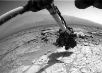
Four Sol 181 activities, as seen from Front Hazcam Right A, 700x500 pixel region, no further processing:
|
|
|
|
|
|
|
Feb 8 2013, 08:26 PM
Post
#248
|
|
|
Senior Member Group: Members Posts: 1465 Joined: 9-February 04 From: Columbus OH USA Member No.: 13 |
QUOTE (mcaplinger @ Feb 8 2013, 09:12 AM) What's the error message? You loaded one of the "ra" kernels, I assume? And you also need to load "msl_struct_v01.bsp" I have the struct kernel at least--here's my kernel file: http://curiosityrover.com/rover2.txt Using the date of the MAHLI image 07FEB2013 1:43:31 UTC gives an et of 413473478. With that et, the follwoing call works fine to get the rotation matrix between MSL_MAHLI and MSL_TOPO pxform_c("MSL_MAHLI","MSL_TOPO",et,cmat) ; But this call to get the MAHLI state fails: spkezr_c("MSL_MAHLI",et,"MSL_TOPO","NONE","MSL_LANDING_SITE",mahlistate,<) ; QUOTE Insufficient ephemeris data has been loaded to compute the state of -76311 (MSL_MAHLI) relative to -76900 (MSL_LANDING_SITE) at the ephemeris epoch 2013 FEB 07 01:44:38.000.
-------------------- |
|
|
|
|
Feb 8 2013, 08:39 PM
Post
#249
|
|
|
Senior Member Group: Members Posts: 2511 Joined: 13-September 05 Member No.: 497 |
QUOTE (jmknapp @ Feb 8 2013, 01:26 PM) I think you need http://naif.jpl.nasa.gov/pub/naif/MSL/kern..._struct_v01.bsp which you don't seem to have; the IK file you do have is not the same thing. -------------------- Disclaimer: This post is based on public information only. Any opinions are my own.
|
|
|
|
|
Feb 8 2013, 08:55 PM
Post
#250
|
|
 Senior Member Group: Members Posts: 1619 Joined: 12-February 06 From: Bergerac - FR Member No.: 678 |
I've dreamed to do this since the Mastcam34 images were released. Sol 176 images bring me closer to that dream. And a little Gimp sausage, and here we go ! A new postcard, at twilight times, from Yellowknife Bay
 . .Enjoy ! 
-------------------- |
|
|
|
|
Feb 8 2013, 09:38 PM
Post
#251
|
|
|
Senior Member Group: Members Posts: 1465 Joined: 9-February 04 From: Columbus OH USA Member No.: 13 |
QUOTE (mcaplinger @ Feb 8 2013, 03:39 PM) I think you need http://naif.jpl.nasa.gov/pub/naif/MSL/kern..._struct_v01.bsp which you don't seem to have; the IK file you do have is not the same thing. Hey, that works--thanks so much. Now to fredk's question, here are the XYZ coordinates (north, east, elev relative to landing site) of the MAHLI camera in meters and rotation angles in degrees for the two shots: 0180MH0146001000E1_DXXX 2013 FEB 07 01:46:35 UTC XYZ [ 0.561 444.523 -17.372 ] roll -4.39, pitch 4.69, yaw 47.94 0180MH0146001001E1_DXXX 2013 FEB 07 01:49:36 UTC XYZ [ 0.566 444.527 -17.371 ] roll -4.38, pitch 4.70, yaw 48.12 Not sure offhand what the best coordinate system is for figuring out the stereo, but those are some numbers anyway! -------------------- |
|
|
|
|
Feb 9 2013, 08:54 AM
Post
#252
|
|
 Senior Member Group: Members Posts: 2428 Joined: 30-January 13 From: Penang, Malaysia. Member No.: 6853 |
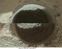
Drill testing continues with another success on Sol 182, so far only a small sequence of MAHLI thumbnails are available of the hole, so difficult to judge the depth, but it appears somewhat deeper than the first one. Like the 'mini drill', there appears to be some tailings at the bottom of the hole
|
|
|
|
|
Feb 9 2013, 10:56 AM
Post
#253
|
|
|
Senior Member Group: Members Posts: 2346 Joined: 7-December 12 Member No.: 6780 |
QUOTE (jmknapp @ Feb 8 2013, 10:38 PM) XYZ [ 0.561 444.523 -17.372 ] XYZ [ 0.566 444.527 -17.371 ] From this we can at least derive the distance of the two points to sqrt(5²+4²+1²)mm=sqrt(42)mm=6.48mm, in good correspondence with the visual inference of the displacement, regarding the 1mm precision; pointing changed just 0.18 degrees. Damien: Great! We can begin to dream of the trip to Mount Sharp. |
|
|
|
|
Feb 9 2013, 11:51 AM
Post
#254
|
||||
|
Senior Member Group: Members Posts: 2346 Joined: 7-December 12 Member No.: 6780 |
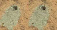
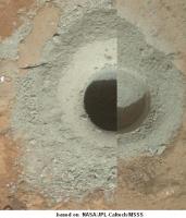
QUOTE (PaulH51 @ Feb 9 2013, 09:54 AM) ... so far only a small sequence of MAHLI thumbnails are available of the hole ... A region of a Sol 182 MAHLI image:
Visually, I get a quotient of the bottom by the top diameter projection of about 0.73. May be this can be used to estimate the relative depth of the two drill holes. EDIT: For a better comparison of the two holes:
and
The distances of the two MAHLI images from the rims seem to be almost the same 5cm. |
|||
|
|
|
|||
|
Feb 9 2013, 01:05 PM
Post
#255
|
||
|
Senior Member Group: Members Posts: 2346 Joined: 7-December 12 Member No.: 6780 |
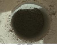
This Sol 182 MAHLI image
seems well-suited for a "relative" shadow method:
I get a bit more than double the depth for the second hole, 2.25-fold as a first draft, comparing the lengths of the shadows relative to the diameter of the respective hole floors. |
|
|
|
|
|
|

|
Lo-Fi Version | Time is now: 27th April 2024 - 10:43 PM |
|
RULES AND GUIDELINES Please read the Forum Rules and Guidelines before posting. IMAGE COPYRIGHT |
OPINIONS AND MODERATION Opinions expressed on UnmannedSpaceflight.com are those of the individual posters and do not necessarily reflect the opinions of UnmannedSpaceflight.com or The Planetary Society. The all-volunteer UnmannedSpaceflight.com moderation team is wholly independent of The Planetary Society. The Planetary Society has no influence over decisions made by the UnmannedSpaceflight.com moderators. |
SUPPORT THE FORUM Unmannedspaceflight.com is funded by the Planetary Society. Please consider supporting our work and many other projects by donating to the Society or becoming a member. |
|