Journey to Mt Sharp - Part 1: Site 7 to Waypoint 1, Sol324 [Jul4,'13] to Sol391 [Sep12,'13] |

  |
Journey to Mt Sharp - Part 1: Site 7 to Waypoint 1, Sol324 [Jul4,'13] to Sol391 [Sep12,'13] |
 Jul 30 2013, 10:44 PM Jul 30 2013, 10:44 PM
Post
#166
|
|
|
Solar System Cartographer  Group: Members Posts: 10173 Joined: 5-April 05 From: Canada Member No.: 227 |
I prefer the idea of them being remnants of a layer of material which is mostly eroded away.
We just drove again, to the south. No position yet, I need full navcams for that. Phil -------------------- ... because the Solar System ain't gonna map itself.
Also to be found posting similar content on https://mastodon.social/@PhilStooke Maps for download (free PD: https://upload.wikimedia.org/wikipedia/comm...Cartography.pdf NOTE: everything created by me which I post on UMSF is considered to be in the public domain (NOT CC, public domain) |
 |
 
|
|
Jul 30 2013, 11:39 PM
Post
#167
|
|
 Member Group: Members Posts: 222 Joined: 7-August 12 From: Garberville, CA Member No.: 6500 |
QUOTE (Gerald @ Jul 30 2013, 02:55 PM)  I've been considering a crushed secondary impact body, with smaller (dark-toned) fragments scattered around, as one of several options. ...or even very high velocity first impact crater sites whose surrounding material has been eroded away by many eons of wind? Several of the rocky mounds in this area look somewhat rounded in appearance in the HIRISE images. So could the hillocks themselves, with their dark rocky boulders, simply be remnants of a once buried but highly compacted crater center, where the ground was super heated by the intense impact, leaving heavily compressed ground (the mounds) and dark rocky impact debris (the boulders) that have since resisted the erosional forces that subsequently removed all evidence of the once overlying craters themselves? Not sure how old they'd have to be for that much erosion to have occurred, but it's a thought anyway. And yup, we're traveling again...Sol 349 Rear Hazcam Anaglyphs. Gives a clue as to the direction maybe.  
-------------------- "We shall not cease from exploration, and the end of all our exploring will be to arrive where we started and know the place for the first time." -T.S. Eliot
|
|
|
|
|
Jul 31 2013, 01:15 AM
Post
#168
|
|
 Senior Member Group: Moderator Posts: 3431 Joined: 11-August 04 From: USA Member No.: 98 |
Her drive direction is not really a mystery now that the NAIF data has been updated. I'm a little surprised she left the dark boulder area so quickly! She really is all about driving these days! Well, looks like there
|
|
|
|
|
Jul 31 2013, 03:36 AM
Post
#169
|
|
 Newbie Group: Members Posts: 12 Joined: 17-July 13 From: Earth Member No.: 6973 |
It also seems that she is migrating from the PSP_010573_1755_ortho onto the ESP_018854_1755 _ortho. The latter aligns and flows nicely with the PSP_009650_1755 dtm. It looks like a mostly smooth surface from the current position to the Mount Sharp Base/Entry. Well, at 1m resolution it does anyway. I bet those looking at the navigation mesh products might disagree.
|
|
|
|
|
Jul 31 2013, 02:18 PM
Post
#170
|
||
|
Solar System Cartographer Group: Members Posts: 10173 Joined: 5-April 05 From: Canada Member No.: 227 |
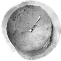
Circular pan from sol 349 - a very interesting area we are passing through!
Phil
-------------------- ... because the Solar System ain't gonna map itself.
Also to be found posting similar content on https://mastodon.social/@PhilStooke Maps for download (free PD: https://upload.wikimedia.org/wikipedia/comm...Cartography.pdf NOTE: everything created by me which I post on UMSF is considered to be in the public domain (NOT CC, public domain) |
|
|
|
|
|
|
Jul 31 2013, 02:56 PM
Post
#171
|
|
|
Junior Member Group: Members Posts: 30 Joined: 6-September 12 From: Denver Member No.: 6641 |
They certainly are putting the petal to the metal. It must be frustrating for the geologists on the science team to see all these beautiful land forms passing by, without taking the time to sample them. I know if would have stopped at each outcrop to chip a small sample and do a quick identification before moving on. But that's the difference between a robotic and organic geologist. It probably would have taken a human explorer a week to do what Curiosity has done in a year. Hey NASA, I'm volunteering. No luck.
|
|
|
|
|
Jul 31 2013, 03:38 PM
Post
#172
|
|
|
Solar System Cartographer Group: Members Posts: 10173 Joined: 5-April 05 From: Canada Member No.: 227 |
ChemCam has been sampling for them, in a sense. And the Navcam geomorphology and Mastcam high resolution imaging have a lot to tell us as well. They got a lot out of the conglomerates at Link and Hottah with just those tools. But I'm sure there will be occasional stops to do a bit more.
For those interested in such calendrical musings, today is the last sol of Mars Year 31, and tomorrow (starting about 19:00 hours this evening UTC) is the first sol of Mars Year 32, using the Clancy calendar which I adopted for my atlas. (This is a planetwide date, so presumably referring to time at the zero meridian, not local lander time anywhere else) Phil -------------------- ... because the Solar System ain't gonna map itself.
Also to be found posting similar content on https://mastodon.social/@PhilStooke Maps for download (free PD: https://upload.wikimedia.org/wikipedia/comm...Cartography.pdf NOTE: everything created by me which I post on UMSF is considered to be in the public domain (NOT CC, public domain) |
|
|
|
|
Jul 31 2013, 04:18 PM
Post
#173
|
|
|
Member Group: Members Posts: 222 Joined: 7-August 12 From: Garberville, CA Member No.: 6500 |
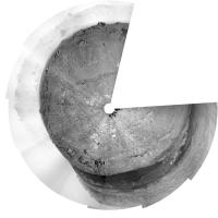
Sol 349 - 360 Degree Navcam Panoramas...
Horizonal Anaglyph:  2-D Full Frame: 
-------------------- "We shall not cease from exploration, and the end of all our exploring will be to arrive where we started and know the place for the first time." -T.S. Eliot
|
|
|
|
|
Aug 1 2013, 12:33 PM
Post
#174
|
|
 Member Group: Members Posts: 161 Joined: 12-August 12 From: Hillsborough, NJ Member No.: 6546 |
Here's Sol 349 with a color corrected mosaic (oops - what Mcaplinger said. Arbitrarily white-balanced):
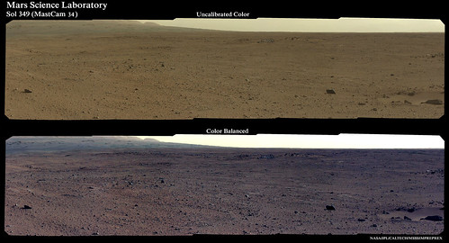 Full sized image: http://www.flickr.com/photos/84750994@N05/...007457/sizes/o/ -------------------- |
|
|
|
|
Aug 1 2013, 02:46 PM
Post
#175
|
|
|
Senior Member Group: Members Posts: 2517 Joined: 13-September 05 Member No.: 497 |
QUOTE (iMPREPREX @ Aug 1 2013, 05:33 AM) Here's Sol 349 with a color corrected mosaic... Rather than "color corrected" it would be more accurate to say "arbitrarily white-balanced." Sorry, pet peeve of mine. -------------------- Disclaimer: This post is based on public information only. Any opinions are my own.
|
|
|
|
|
Aug 1 2013, 03:38 PM
Post
#176
|
||
|
Solar System Cartographer Group: Members Posts: 10173 Joined: 5-April 05 From: Canada Member No.: 227 |
Don't panic! Phil -------------------- ... because the Solar System ain't gonna map itself.
Also to be found posting similar content on https://mastodon.social/@PhilStooke Maps for download (free PD: https://upload.wikimedia.org/wikipedia/comm...Cartography.pdf NOTE: everything created by me which I post on UMSF is considered to be in the public domain (NOT CC, public domain) |
|
|
|
|
|
|
Aug 1 2013, 04:02 PM
Post
#177
|
|
|
Junior Member Group: Members Posts: 30 Joined: 6-September 12 From: Denver Member No.: 6641 |
I guess that I am not alone. So many rocks. The next rover needs a rock hammer.
|
|
|
|
|
Aug 1 2013, 10:09 PM
Post
#178
|
|
|
Solar System Cartographer Group: Members Posts: 10173 Joined: 5-April 05 From: Canada Member No.: 227 |
A new drive... turning west again - a bit south of west onto some bright outcrops. More later...
Phil -------------------- ... because the Solar System ain't gonna map itself.
Also to be found posting similar content on https://mastodon.social/@PhilStooke Maps for download (free PD: https://upload.wikimedia.org/wikipedia/comm...Cartography.pdf NOTE: everything created by me which I post on UMSF is considered to be in the public domain (NOT CC, public domain) |
|
|
|
|
Aug 2 2013, 12:34 AM
Post
#179
|
|
|
Member Group: Members Posts: 161 Joined: 12-August 12 From: Hillsborough, NJ Member No.: 6546 |
These guys just came down. Sol 324 (#1315):
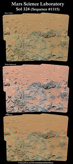 Full sized image: http://www.flickr.com/photos/84750994@N05/...086279/sizes/o/ GigaPan: http://www.flickr.com/photos/84750994@N05/...086279/sizes/o/ And edited to add this from Sol 331. Tracks! 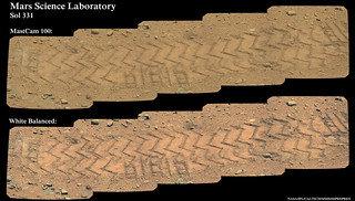 Full sized image: www.flickr.com/photos/84750994@N05/9420373142/sizes/o/ Cool. 
-------------------- |
|
|
|
|
Aug 2 2013, 02:37 AM
Post
#180
|
|||
|
Solar System Cartographer Group: Members Posts: 10173 Joined: 5-April 05 From: Canada Member No.: 227 |
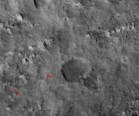
Here is the new location - proper map update tomorrow - and a circular pan from 351.
Phil
-------------------- ... because the Solar System ain't gonna map itself.
Also to be found posting similar content on https://mastodon.social/@PhilStooke Maps for download (free PD: https://upload.wikimedia.org/wikipedia/comm...Cartography.pdf NOTE: everything created by me which I post on UMSF is considered to be in the public domain (NOT CC, public domain) |
||
|
|
|
||
|

|
Lo-Fi Version | Time is now: 1st June 2024 - 02:09 AM |
|
RULES AND GUIDELINES Please read the Forum Rules and Guidelines before posting. IMAGE COPYRIGHT |
OPINIONS AND MODERATION Opinions expressed on UnmannedSpaceflight.com are those of the individual posters and do not necessarily reflect the opinions of UnmannedSpaceflight.com or The Planetary Society. The all-volunteer UnmannedSpaceflight.com moderation team is wholly independent of The Planetary Society. The Planetary Society has no influence over decisions made by the UnmannedSpaceflight.com moderators. |
SUPPORT THE FORUM Unmannedspaceflight.com is funded by the Planetary Society. Please consider supporting our work and many other projects by donating to the Society or becoming a member. |
|