Journey to Mt Sharp - Part 1: Site 7 to Waypoint 1, Sol324 [Jul4,'13] to Sol391 [Sep12,'13] |

  |
Journey to Mt Sharp - Part 1: Site 7 to Waypoint 1, Sol324 [Jul4,'13] to Sol391 [Sep12,'13] |
 Aug 8 2013, 09:13 AM Aug 8 2013, 09:13 AM
Post
#241
|
|
 Senior Member  Group: Members Posts: 1465 Joined: 9-February 04 From: Columbus OH USA Member No.: 13 |
For anyone following @curiositylog and excited about the reported 125 meter drive on sol 356, it looks like there's a glitch in the SPICE data files. Here are the last few records of the track sampled every 100 seconds:
QUOTE {"sol":356,"utc":"2013-08-06T22:19:34Z","lmst":"01:14:37 P.M.","et":429099641,"longitude":137.436576,"latitude":-4.597385,"altitude":-4442.29}, {"sol":356,"utc":"2013-08-06T22:21:14Z","lmst":"01:16:14 P.M.","et":429099741,"longitude":137.436561,"latitude":-4.597388,"altitude":-4442.33}, {"sol":356,"utc":"2013-08-06T22:24:34Z","lmst":"01:19:29 P.M.","et":429099941,"longitude":137.437050,"latitude":-4.597299,"altitude":-4442.04}, {"sol":356,"utc":"2013-08-06T22:26:14Z","lmst":"01:21:06 P.M.","et":429100041,"longitude":137.436561,"latitude":-4.597388,"altitude":-4442.33}, So the longitude jumps from 137.436561 to 137.437050 and back again at the end of the track. I changed the code to filter out impossible rover speeds, so now the track log is cleaner and the sol 356 distance is 50.82 meters. -------------------- |
 |
 
|
|
Aug 8 2013, 11:36 AM
Post
#242
|
|
 Senior Member Group: Members Posts: 2492 Joined: 15-January 05 From: center Italy Member No.: 150 |
QUOTE (jmknapp @ Aug 8 2013, 09:13 AM)  ... I changed the code to filter out impossible rover speeds, so now the track log is cleaner and the sol 356 distance is 50.82 meters. Well done, Joe... I just updated my odometry file/plots. I see you changed also drive numbers, suppressing previous #44 which was a 0-meters shift! -------------------- I always think before posting! - Marco -
|
|
|
|
|
Aug 8 2013, 03:02 PM
Post
#243
|
|
 Member Group: Members Posts: 112 Joined: 20-August 12 From: Spain Member No.: 6597 |
I was merging some of the Sol 352 ML frames and Aeolis Mons looks really beautiful
 
|
|
|
|
|
Aug 8 2013, 03:22 PM
Post
#244
|
|
|
Senior Member Group: Members Posts: 1465 Joined: 9-February 04 From: Columbus OH USA Member No.: 13 |
Good work getting that detail out.
BTW, what is the deal with the MARDI shots on this trek? They've been taking a MARDI shot on every drive sol, always around the same time, about a half hour after sunset (~7pm). -------------------- |
|
|
|
|
Aug 8 2013, 03:50 PM
Post
#245
|
|
 Administrator Group: Admin Posts: 5172 Joined: 4-August 05 From: Pasadena, CA, USA, Earth Member No.: 454 |
The MARDI shots are a way to survey the diversity of the pebbles on the ground. The straight-down view makes it easy to get precise measurements on their sizes and shapes. Jim Garvin is doing this work; here's his LPSC abstract.
-------------------- My website - My Patreon - @elakdawalla on Twitter - Please support unmannedspaceflight.com by donating here.
|
|
|
|
|
Aug 8 2013, 06:06 PM
Post
#246
|
|
 Member Group: Members Posts: 691 Joined: 21-December 07 From: Clatskanie, Oregon Member No.: 3988 |
My take on the Sol-352 M34 Pan sofar.
  |
|
|
|
|
Aug 8 2013, 06:07 PM
Post
#247
|
|
 Member Group: Members Posts: 238 Joined: 15-January 13 Member No.: 6842 |
QUOTE (jmknapp @ Aug 8 2013, 04:22 PM) Good work getting that detail out. BTW, what is the deal with the MARDI shots on this trek? They've been taking a MARDI shot on every drive sol, always around the same time, about a half hour after sunset (~7pm). Related update from Ken http://astrogeology.usgs.gov/news?p=2&...f-twilight-wins QUOTE We are planning MAHLI and MARDI images after the drive, to document the terrain in the new location. On Sol 318, we took MARDI images at various times of day to determine when to best acquire such images. The images show that images taken in twilight (right after sunset) best show details of the terrain next to the left front wheel. Because dust was deposited on MARDI's lens during landing, the contrast in MARDI images is reduced. During twilight, less light is scattered off the dusty optics.
-------------------- Curiosity rover panoramas: http://www.facebook.com/CuriosityRoverPanoramas
My Photosynth panoramas: http://photosynth.net/userprofilepage.aspx...;content=Synths |
|
|
|
|
Aug 8 2013, 06:37 PM
Post
#248
|
||
 Senior Member Group: Members Posts: 4246 Joined: 17-January 05 Member No.: 152 |
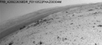
It's fascinating how a patch of the mountainside appears to disappear (arrowed) at certain times of day, when the lighting is just right:
I guess with just the right angle of illumination, the surface brightness of that patch matches almost perfectly the surface brightness of the adjacent sky (at least integrated over the hazcam spectral response), so it looks as if we're seeing through a "gap" in the mountainside. It reminds me of some kind of atmospheric "mirage" effect, though I'd guess that's unlikely with the low air density on Mars. Here are the original frames: http://mars.jpl.nasa.gov/msl-raw-images/pr...FHAZ00304M_.JPG http://mars.jpl.nasa.gov/msl-raw-images/pr...FHAZ00323M_.JPG And another one which shows the "mirage" on a different sol, presumably near the same local time: http://mars.jpl.nasa.gov/msl-raw-images/pr...FHAZ00323M_.JPG I haven't been able to find navcam or mastcam imagery showing the "mirage", but I'd love to see some... |
|
|
|
|
|
|
Aug 8 2013, 07:59 PM
Post
#249
|
|
 Member Group: Members Posts: 404 Joined: 5-January 10 Member No.: 5161 |
QUOTE (fredk @ Aug 8 2013, 11:37 AM) It's fascinating how a patch of the mountainside appears to disappear (arrowed) at certain times of day... That is very weird, and the same part of the mountain, too, in those two images in which it appears. On the "flicker-GIF," were the two images taken nearly around the same time? |
|
|
|
|
Aug 8 2013, 08:05 PM
Post
#250
|
|
|
Founder Group: Chairman Posts: 14432 Joined: 8-February 04 Member No.: 1 |
QUOTE (walfy @ Aug 8 2013, 11:59 AM) were the two images taken nearly around the same time? Clearly not - just look at the shadows in the imagery - Fred has give you links to it. |
|
|
|
|
Aug 8 2013, 08:36 PM
Post
#251
|
|
|
Senior Member Group: Members Posts: 1465 Joined: 9-February 04 From: Columbus OH USA Member No.: 13 |
Thanks, Emily & wildespace, that really explains what they are doing with the MARDI shots. Who knew that Mars pebble size follows a log-hyperbolic distribution?
Per the abstract, Dr. Garvin found the preliminary data to be most consistent with volcanic ejecta. -------------------- |
|
|
|
|
Aug 8 2013, 10:52 PM
Post
#252
|
|
 Member Group: Members Posts: 161 Joined: 12-August 12 From: Hillsborough, NJ Member No.: 6546 |
-------------------- |
|
|
|
|
Aug 8 2013, 10:52 PM
Post
#253
|
|
|
Member Group: Members Posts: 866 Joined: 15-March 05 From: Santa Cruz, CA Member No.: 196 |
QUOTE (fredk @ Aug 8 2013, 10:37 AM) It's fascinating how a patch of the mountainside appears to disappear (arrowed) at certain times of day, when the lighting is just right: Didn't expect the hazcam compression to average-away the ridge quite like that, but i do remember seeing many instances of disappearing horizons in the MER data sort of like this but much worse (some even had jagged serrations at the clipping point). perhaps they have improved those algorithms but this is still an an edge case exploiting a sweet-spot, helpful specs in section 2.7 though i haven't quite digested.. |
|
|
|
|
Aug 9 2013, 12:45 AM
Post
#254
|
|
|
Senior Member Group: Members Posts: 4246 Joined: 17-January 05 Member No.: 152 |
QUOTE (atomoid @ Aug 8 2013, 11:52 PM) Didn't expect the hazcam compression to average-away the ridge quite like that, but i do remember seeing many instances of disappearing horizons in the MER data sort of like this but much worse (some even had jagged serrations at the clipping point). We've definitely seen examples with MER where the sky is overexposed and it "bleeds" across the horizon because of how the CCD works. But that's not what we're seeing here - the sky is nowhere near overexposed. I think the mountainside in that direction really does happen to match the brightness of the sky fairly closely, at the right time of day. But navcams or mastcams would settle it. PS - haven't noticed this sort of white layer since back around Yellowknife Bay: http://mars.jpl.nasa.gov/msl-raw-images/ms...4000E1_DXXX.jpg |
|
|
|
|
Aug 9 2013, 02:00 AM
Post
#255
|
|
 Martian Photographer Group: Members Posts: 352 Joined: 3-March 05 Member No.: 183 |
I recall some Phoenix albedo pans where the terrain blended into the sky without a horizon line, due to a radiance match. That's not possible with the color cameras, or in color pans in general, due to the sky being bluer. But that's not as funky as this.
|
|
|
|
|

|
Lo-Fi Version | Time is now: 3rd May 2024 - 04:59 PM |
|
RULES AND GUIDELINES Please read the Forum Rules and Guidelines before posting. IMAGE COPYRIGHT |
OPINIONS AND MODERATION Opinions expressed on UnmannedSpaceflight.com are those of the individual posters and do not necessarily reflect the opinions of UnmannedSpaceflight.com or The Planetary Society. The all-volunteer UnmannedSpaceflight.com moderation team is wholly independent of The Planetary Society. The Planetary Society has no influence over decisions made by the UnmannedSpaceflight.com moderators. |
SUPPORT THE FORUM Unmannedspaceflight.com is funded by the Planetary Society. Please consider supporting our work and many other projects by donating to the Society or becoming a member. |
|