Opportunity Route Map |

  |
Opportunity Route Map |
 Sep 30 2013, 08:50 PM Sep 30 2013, 08:50 PM
Post
#3226
|
||
|
Senior Member  Group: Moderator Posts: 4279 Joined: 19-April 05 From: .br at .es Member No.: 253 |
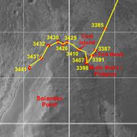
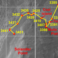
A quick update, good up to sol 3441, but I still have to double-check the last two positions against the navcam mosaics.
 Route_Map_Sol3441.kmz ( 25.42K )
Number of downloads: 309
Route_Map_Sol3441.kmz ( 25.42K )
Number of downloads: 309 |
|
 |
 
|
|
|
Oct 9 2013, 09:22 PM
Post
#3227
|
|
|
Senior Member Group: Moderator Posts: 4279 Joined: 19-April 05 From: .br at .es Member No.: 253 |
Time for another update, with the latest data from sol 3451.
 Route_Map_Sol3451.kmz ( 25.45K )
Number of downloads: 299
Route_Map_Sol3451.kmz ( 25.45K )
Number of downloads: 299 |
|
|
|
|
Oct 9 2013, 09:32 PM
Post
#3228
|
||
|
Solar System Cartographer Group: Members Posts: 10173 Joined: 5-April 05 From: Canada Member No.: 227 |
Thanks as ever to Tesheiner for updating this map so faithfully.
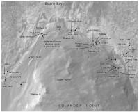
I was just putting this together for my book and thought I would share it. I still have a few names to add, I think, and a scale. The white squares are the main science stops - a little refinement I have just been adding retroactively to maps for all rovers in the atlas. Phil
-------------------- ... because the Solar System ain't gonna map itself.
Also to be found posting similar content on https://mastodon.social/@PhilStooke Maps for download (free PD: https://upload.wikimedia.org/wikipedia/comm...Cartography.pdf NOTE: everything created by me which I post on UMSF is considered to be in the public domain (NOT CC, public domain) |
|
|
|
|
|
|
Oct 10 2013, 07:06 AM
Post
#3229
|
|
|
Senior Member Group: Moderator Posts: 4279 Joined: 19-April 05 From: .br at .es Member No.: 253 |
Wow! Please share those more often, Phil.

|
|
|
|
|
Oct 11 2013, 02:14 AM
Post
#3230
|
|
|
Member Group: Members Posts: 139 Joined: 14-October 05 From: Toronto, Canada Member No.: 529 |
I second that!

-------------------- -- Robin
|
|
|
|
|
Oct 17 2013, 04:18 PM
Post
#3231
|
|
|
Member Group: Members Posts: 122 Joined: 19-June 07 Member No.: 2455 |
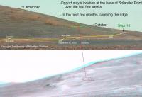
Amazing work you guys do. A request for one different view as we proceed up the hill. Could someone take a far off ground level view of Solander Point and from time to time show the general location on the side of that hill? All those outcrops are looking very alike and while the overheads are wonderful, I'm just not getting a feel for how much up is involved in each move.
|
|
|
|
|
Oct 17 2013, 05:00 PM
Post
#3232
|
|
|
Senior Member Group: Moderator Posts: 4279 Joined: 19-April 05 From: .br at .es Member No.: 253 |
I think that Midnight Planets can do exactly that.
|
|
|
|
|
Oct 17 2013, 08:32 PM
Post
#3233
|
|
 Senior Member Group: Moderator Posts: 3431 Joined: 11-August 04 From: USA Member No.: 98 |
It can certainly help visualize where the rover is, but the raw tracking data is not precise enough to accurately place the rover from a significant distance (or sometimes, as you know, even from a moderate distance). And I haven't had time to do my own corrections of the tracking data so far.
|
|
|
|
|
Oct 17 2013, 08:46 PM
Post
#3234
|
|
|
Solar System Cartographer Group: Members Posts: 10173 Joined: 5-April 05 From: Canada Member No.: 227 |
Art, you may want to check this out - second image down on this page.
Phil http://nmnaturalhistory.org/rover-field-re...-from-mars.html -------------------- ... because the Solar System ain't gonna map itself.
Also to be found posting similar content on https://mastodon.social/@PhilStooke Maps for download (free PD: https://upload.wikimedia.org/wikipedia/comm...Cartography.pdf NOTE: everything created by me which I post on UMSF is considered to be in the public domain (NOT CC, public domain) |
|
|
|
|
Oct 17 2013, 09:36 PM
Post
#3235
|
||
|
Senior Member Group: Moderator Posts: 3431 Joined: 11-August 04 From: USA Member No.: 98 |
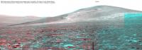
Here's where I think "Kangaroo Paw" (Sol 3459) is on the Sol 3366 long baseline stereo mosaic. This is based on a whole lot of looking around, but I could easily be wrong... corrections welcome.
Attached thumbnail(s)
|
|
|
|
|
|
|
Oct 17 2013, 09:37 PM
Post
#3236
|
|
 Administrator Group: Admin Posts: 5172 Joined: 4-August 05 From: Pasadena, CA, USA, Earth Member No.: 454 |
Ooh, neat, and thanks for doing it in 3D!
-------------------- My website - My Patreon - @elakdawalla on Twitter - Please support unmannedspaceflight.com by donating here.
|
|
|
|
|
Oct 17 2013, 09:45 PM
Post
#3237
|
|
|
Solar System Cartographer Group: Members Posts: 10173 Joined: 5-April 05 From: Canada Member No.: 227 |
I think that's right - there are three rocky spurs - tiny outcrops - here, seen in Navcams, and we can see them here in your anaglyph.
Phil -------------------- ... because the Solar System ain't gonna map itself.
Also to be found posting similar content on https://mastodon.social/@PhilStooke Maps for download (free PD: https://upload.wikimedia.org/wikipedia/comm...Cartography.pdf NOTE: everything created by me which I post on UMSF is considered to be in the public domain (NOT CC, public domain) |
|
|
|
|
Oct 17 2013, 09:55 PM
Post
#3238
|
|
|
Senior Member Group: Members Posts: 3516 Joined: 4-November 05 From: North Wales Member No.: 542 |
That's very helpful. I remember many such virtual views from a distance being posted when we were at Victoria crater. I think it's time to resurrect the genre. We're on a convex slope here so the view from the rover is limited and not easily related to the wider context.
|
|
|
|
|
Oct 17 2013, 11:57 PM
Post
#3239
|
|
 Senior Member Group: Members Posts: 4247 Joined: 17-January 05 Member No.: 152 |
Looks like a good position. Thanks for doing this.
|
|
|
|
|
Oct 18 2013, 01:29 AM
Post
#3240
|
||
 Senior Member Group: Members Posts: 2173 Joined: 28-December 04 From: Florida, USA Member No.: 132 |
Total stab-in-the-dark attempt to relate the positions in the last two perspectives in Phil's link and mhoward's post.
|
|
|
|
|
|
|

|
Lo-Fi Version | Time is now: 1st June 2024 - 09:39 AM |
|
RULES AND GUIDELINES Please read the Forum Rules and Guidelines before posting. IMAGE COPYRIGHT |
OPINIONS AND MODERATION Opinions expressed on UnmannedSpaceflight.com are those of the individual posters and do not necessarily reflect the opinions of UnmannedSpaceflight.com or The Planetary Society. The all-volunteer UnmannedSpaceflight.com moderation team is wholly independent of The Planetary Society. The Planetary Society has no influence over decisions made by the UnmannedSpaceflight.com moderators. |
SUPPORT THE FORUM Unmannedspaceflight.com is funded by the Planetary Society. Please consider supporting our work and many other projects by donating to the Society or becoming a member. |
|