Exploring Murray Ridge, Sol 3600 - 3743 (March 11, 2014 - August 5, 2014) |

  |
Exploring Murray Ridge, Sol 3600 - 3743 (March 11, 2014 - August 5, 2014) |
 Apr 22 2014, 02:17 PM Apr 22 2014, 02:17 PM
Post
#106
|
||
|
Senior Member  Group: Members Posts: 2820 Joined: 22-April 05 From: Ridderkerk, Netherlands Member No.: 353 |
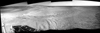
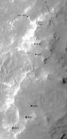
It looks like Opportunity is on the 1st summit on Sol 3641.
Jan van Driel
|
|
 |
 
|
|
|
Apr 22 2014, 03:04 PM
Post
#107
|
|
 Senior Member Group: Members Posts: 4246 Joined: 17-January 05 Member No.: 152 |
As Viking's first pic shows, the "first summit" is very broad and flat, but since we can see over it now it does look like we've crested it.
The "second summit" is along the clay signature we're headed for, and with these energy levels we could get there fast... |
|
|
|
|
Apr 22 2014, 09:16 PM
Post
#108
|
|||
|
Solar System Cartographer Group: Members Posts: 10153 Joined: 5-April 05 From: Canada Member No.: 227 |
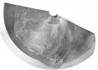
Here's a circular version of the 3641 mini-pan to show where we are, and a map showing the location (I am deliberately not drawing this up as a full map and putting it in the route map thread because I don't want to take over the 'official' Opportunity mapping)
Phil
-------------------- ... because the Solar System ain't gonna map itself.
Also to be found posting similar content on https://mastodon.social/@PhilStooke Maps for download (free PD: https://upload.wikimedia.org/wikipedia/comm...Cartography.pdf NOTE: everything created by me which I post on UMSF is considered to be in the public domain (NOT CC, public domain) |
||
|
|
|
||
|
Apr 22 2014, 11:19 PM
Post
#109
|
|
|
Member Group: Members Posts: 910 Joined: 4-September 06 From: Boston Member No.: 1102 |
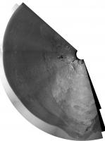
Hi Phil or any other cartographer--could you post a larger context image of all of Murray Ridge or Murray Ridge and Tribulation (either here or in the map thread). In the map thread I went back a dozen or more pages and could not find a helpful context map. The map of the all of Endurance is too large--sorry to be picky.
Thanks in advance fredk [how did I know fredk would post--must be a time warp] -------------------- |
|
|
|
|
Apr 23 2014, 12:14 AM
Post
#110
|
|
|
Senior Member Group: Members Posts: 4246 Joined: 17-January 05 Member No.: 152 |
This image extends just a bit into Tribulation.
|
|
|
|
|
Apr 23 2014, 11:02 AM
Post
#111
|
||
|
Senior Member Group: Members Posts: 1074 Joined: 21-September 07 From: Québec, Canada Member No.: 3908 |
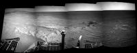
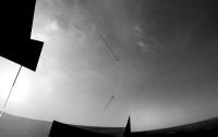
Sol 3642 navcam pan: clear view of Cape Tribulation.
|
|
|
|
|
|
|
Apr 23 2014, 11:47 AM
Post
#112
|
|
|
Member Group: Members Posts: 154 Joined: 21-April 05 From: Rochester, New York, USA Member No.: 336 |
I'm sure this was posted here before, but as we get closer to the big clay signature it seemed worth a second look.
http://www.nasa.gov/mission_pages/mer/mult...y/pia13708.html Also, one of many papers you get by searching the web for papers on the topic: http://www.planetary.brown.edu/pdfs/3954.pdf |
|
|
|
|
Apr 23 2014, 03:21 PM
Post
#113
|
|
|
Senior Member Group: Members Posts: 4246 Joined: 17-January 05 Member No.: 152 |
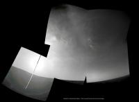
Very nice cloud sequence on 3640, eg
http://qt.exploratorium.edu/mars/opportuni...0M1.JPG?sol3640 There are four good cloud images that piece together in pairs (I can't see the two pairs fit together). Definitely an advanced stitching job for our resident experts, considering cloud movement and stretching differences... On another topic, the tau measurements have plummetted down close to 0.2 recently, which is very low for this (or any) time of year. There's always some potential degeneracy with dust factor which relies on modelling to resolve, but still this is probably as good as it gets for imaging distant features. |
|
|
|
|
Apr 23 2014, 04:21 PM
Post
#114
|
||
 Senior Member Group: Members Posts: 1619 Joined: 12-February 06 From: Bergerac - FR Member No.: 678 |
I'm on it
 Beautiful clouds there !
Attached thumbnail(s)
-------------------- |
|
|
|
|
|
|
Apr 23 2014, 05:00 PM
Post
#115
|
|||
|
Solar System Cartographer Group: Members Posts: 10153 Joined: 5-April 05 From: Canada Member No.: 227 |
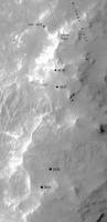
Latest position and a reprojected pan originally from Charborob.
Phil
-------------------- ... because the Solar System ain't gonna map itself.
Also to be found posting similar content on https://mastodon.social/@PhilStooke Maps for download (free PD: https://upload.wikimedia.org/wikipedia/comm...Cartography.pdf NOTE: everything created by me which I post on UMSF is considered to be in the public domain (NOT CC, public domain) |
||
|
|
|
||
|
Apr 23 2014, 07:24 PM
Post
#116
|
|
 Senior Member Group: Members Posts: 3419 Joined: 9-February 04 From: Minneapolis, MN, USA Member No.: 15 |
QUOTE (Ant103 @ Apr 23 2014, 11:21 AM)  Beautiful clouds there ! Yep -- and I believe that the brighter cloud arc to the right of the (not imaged) solar disc may well be a sundog. Looks like a subtle arc forming a portion of a halo around the sun, not directly associated with the cloud structures. Cool! -the other Doug (with my shield, not yet upon it) -------------------- The trouble ain't that there is too many fools, but that the lightning ain't distributed right. -Mark Twain
|
|
|
|
|
Apr 23 2014, 07:55 PM
Post
#117
|
|
|
Senior Member Group: Members Posts: 4246 Joined: 17-January 05 Member No.: 152 |
Doug - any chance you could point to your arc candidate on an image?
|
|
|
|
|
Apr 23 2014, 08:05 PM
Post
#118
|
|
 Martian Photographer Group: Members Posts: 352 Joined: 3-March 05 Member No.: 183 |
fredk: I would bet on tau retroactively jumping up within a week or so. The reported values are quite extraordinary.
|
|
|
|
|
Apr 24 2014, 12:59 AM
Post
#119
|
||
|
Senior Member Group: Members Posts: 3419 Joined: 9-February 04 From: Minneapolis, MN, USA Member No.: 15 |
QUOTE (fredk @ Apr 23 2014, 01:55 PM) Doug - any chance you could point to your arc candidate on an image? Sure. Here's a piece of the cloud mosaic; the black arrows point to the top and bottom of the arc that I'm seeing. I put a green bracket to the left of the arc I'm seeing, as well. Now, the thing that makes it look like a sundog to me is that in the middle of the arc, it looks like the cloud structure is unchanged but that it glows more brightly than to the right or left, or even up and down the ring arc a bit. That would be the center of the sundog on the right side of the sun. I've seen the same kind of thing here on Earth thousands of times, and this looks like the same thing to me... -the other Doug (with my shield, not yet upon it)
-------------------- The trouble ain't that there is too many fools, but that the lightning ain't distributed right. -Mark Twain
|
|
|
|
|
|
|
Apr 24 2014, 01:14 AM
Post
#120
|
|
|
Founder Group: Chairman Posts: 14432 Joined: 8-February 04 Member No.: 1 |
I doubt it's a sun-dog/halo. Those are 22 degrees from the sun usually, and this looks to be at least one NavCam FOV (45 deg) from the sun
Simulations here http://www.atoptics.co.uk/halo/owmars.htm More likely an internal reflection from the camera |
|
|
|
|

|
Lo-Fi Version | Time is now: 28th April 2024 - 05:12 AM |
|
RULES AND GUIDELINES Please read the Forum Rules and Guidelines before posting. IMAGE COPYRIGHT |
OPINIONS AND MODERATION Opinions expressed on UnmannedSpaceflight.com are those of the individual posters and do not necessarily reflect the opinions of UnmannedSpaceflight.com or The Planetary Society. The all-volunteer UnmannedSpaceflight.com moderation team is wholly independent of The Planetary Society. The Planetary Society has no influence over decisions made by the UnmannedSpaceflight.com moderators. |
SUPPORT THE FORUM Unmannedspaceflight.com is funded by the Planetary Society. Please consider supporting our work and many other projects by donating to the Society or becoming a member. |
|