Journey to Mt Sharp - Part 5A: Pahrump Hills, Sites 42-45, Sol 753-923, Sep 18, 2014-March 12, 2015 |

  |
Journey to Mt Sharp - Part 5A: Pahrump Hills, Sites 42-45, Sol 753-923, Sep 18, 2014-March 12, 2015 |
 Nov 24 2014, 06:24 PM Nov 24 2014, 06:24 PM
Post
#241
|
||
 Member  Group: Members Posts: 334 Joined: 11-December 12 From: The home of Corby Crater (Corby-England) Member No.: 6783 |
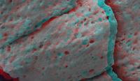
Swiss Pumice Cheese

|
|
 |
 
|
|
|
Nov 24 2014, 07:06 PM
Post
#242
|
||
|
Member Group: Members Posts: 334 Joined: 11-December 12 From: The home of Corby Crater (Corby-England) Member No.: 6783 |
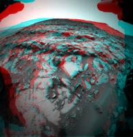
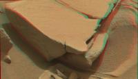
A Sol818 FHaz anaglyph
|
|
|
|
|
|
|
Nov 24 2014, 07:07 PM
Post
#243
|
||
|
Senior Member Group: Members Posts: 2837 Joined: 22-April 05 From: Ridderkerk, Netherlands Member No.: 353 |
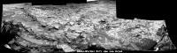
The Navcam view on Sol 817.
Jan van Driel
|
|
|
|
|
|
|
Nov 24 2014, 07:59 PM
Post
#244
|
|
|
Member Group: Members Posts: 334 Joined: 11-December 12 From: The home of Corby Crater (Corby-England) Member No.: 6783 |
I think the image from my previous post is the HazCam view of what is vertically above the 'I' in Curiosity in Jans' pan above
|
|
|
|
|
Nov 25 2014, 02:15 AM
Post
#245
|
||
|
Solar System Cartographer Group: Members Posts: 10185 Joined: 5-April 05 From: Canada Member No.: 227 |
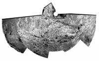
Circular version of Jan's pan:
Phil -------------------- ... because the Solar System ain't gonna map itself.
Also to be found posting similar content on https://mastodon.social/@PhilStooke Maps for download (free PD: https://upload.wikimedia.org/wikipedia/comm...Cartography.pdf NOTE: everything created by me which I post on UMSF is considered to be in the public domain (NOT CC, public domain) |
|
|
|
|
|
|
Nov 26 2014, 01:58 PM
Post
#246
|
|
|
Senior Member Group: Members Posts: 2346 Joined: 7-December 12 Member No.: 6780 |
Focus-stacked Sol 819 MAHLI of a brushed surface.
The rock looks like a sandstone or a sandy mudstone with some whitish veins, and mostly angular grains. Most grains look greyish, some grains look reddish-orangish. Here a version enhancing the most saturated patches:  Comparing saturation of the orangish spots hints towards an iron contents above the iron contents of the ubiquitious dust. The hue of the orangish spots seems to indicate high iron-III as hematite; goethite and limonite low, if any. |
|
|
|
|
Nov 26 2014, 10:57 PM
Post
#247
|
|
|
Member Group: Members Posts: 866 Joined: 15-March 05 From: Santa Cruz, CA Member No.: 196 |
|
|
|
|
|
Nov 27 2014, 02:10 AM
Post
#248
|
|
|
Senior Member Group: Members Posts: 1074 Joined: 21-September 07 From: Québec, Canada Member No.: 3908 |
Why do you call it a pumice?
|
|
|
|
|
Nov 27 2014, 10:21 AM
Post
#249
|
|
|
Senior Member Group: Members Posts: 2346 Joined: 7-December 12 Member No.: 6780 |
My favorite interpretation candidates for the layering (Sol 819) thus far are annual (glacial?) varves (favorite), and cross-beddings (backup).
Thus far I didn't see clear evidence for cross-bedding. (And no evidence at all for pyroclastic activity.) |
|
|
|
|
Nov 28 2014, 01:32 AM
Post
#250
|
|
|
Senior Member Group: Members Posts: 1045 Joined: 17-February 09 Member No.: 4605 |
I stand to be corrected but this looks more like planar (near horizontal) lamination formed in a low flow strength regime.
|
|
|
|
|
Dec 2 2014, 03:14 PM
Post
#251
|
|
|
Senior Member Group: Members Posts: 2346 Joined: 7-December 12 Member No.: 6780 |
Target "Mescal" at Pahrump Hills / Alexander Hills with context images, sols 819 and 822:
 The scale for the highest resolved MAHLI is calculated according to the formulas of this post from a motor count of 14762 taken from this image, since the motor count 14426 of the used focus stacked image refers to a subframe which has been out of focus. If the rock can roughly be classified as an arkose (feldspar-rich sandstone with angular grains, usually poorly sorted), the outcrop may be located in the lower parts (middle or tail) of an alluvial fan, as far as notions from Earth are applicable. Interesting enough, even the richness in hematite (redness) matches. The size of the sand grains looks like about 1 mm. According to the Wentworth chart, and applying a factor of 0.6 due to the lower gravity, the settling velocity for angular grains should have been near 6 cm/s, threshold velocity for traction near 30 cm/s. I'm going to reduce the probability for the varve interpretation of the lamination. |
|
|
|
|
Dec 2 2014, 05:55 PM
Post
#252
|
|
|
Junior Member Group: Members Posts: 30 Joined: 6-September 12 From: Denver Member No.: 6641 |
Great analysis Gerald. I thought these deposits were older than the alluvial fan. I guess it is possible and probably that there were multiple episodes of fan deposition, but given the distinct mineralogy difference, I would suspects a different deposition mechanism.
|
|
|
|
|
Dec 2 2014, 06:05 PM
Post
#253
|
|
 Member Group: Members Posts: 125 Joined: 19-November 14 From: Québec Member No.: 7339 |
Translation with Google My opignon on the subject:
Event impacts and hydrothermal event loingtain seasoned and sudden collapse. -------------------- |
|
|
|
| Guest_Actionman_* |
Dec 2 2014, 06:46 PM
Post
#254
|
|
Guests |
My Florida sand grain size is:
~.15mm (inland) |
|
|
|
|
Dec 2 2014, 08:18 PM
Post
#255
|
||
|
Member Group: Members Posts: 334 Joined: 11-December 12 From: The home of Corby Crater (Corby-England) Member No.: 6783 |
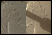
A comparison of two MAHLI images of the same target.
One from Sol34, the other from Sol825.
Without cheating! Which is which?
|
|
|
|
|
|
|

|
Lo-Fi Version | Time is now: 5th June 2024 - 06:20 PM |
|
RULES AND GUIDELINES Please read the Forum Rules and Guidelines before posting. IMAGE COPYRIGHT |
OPINIONS AND MODERATION Opinions expressed on UnmannedSpaceflight.com are those of the individual posters and do not necessarily reflect the opinions of UnmannedSpaceflight.com or The Planetary Society. The all-volunteer UnmannedSpaceflight.com moderation team is wholly independent of The Planetary Society. The Planetary Society has no influence over decisions made by the UnmannedSpaceflight.com moderators. |
SUPPORT THE FORUM Unmannedspaceflight.com is funded by the Planetary Society. Please consider supporting our work and many other projects by donating to the Society or becoming a member. |
|