Distant Vistas 2 - The view from Cape Tribulation |

  |
Distant Vistas 2 - The view from Cape Tribulation |
 Jan 18 2015, 03:38 AM Jan 18 2015, 03:38 AM
Post
#76
|
|
|
Member  Group: Members Posts: 808 Joined: 10-October 06 From: Maynard Mass USA Member No.: 1241 |
James, your work is incredible! Thank you for sharing your skills!
-------------------- CLA CLL
|
 |
 
|
|
Jan 18 2015, 05:04 AM
Post
#77
|
|
|
Member Group: Members Posts: 204 Joined: 14-April 06 From: Seattle, WA Member No.: 745 |
OMG!
I am glad I have lived to see a view like this from Mars. Thank you, James. 
|
|
|
|
|
Jan 18 2015, 03:32 PM
Post
#78
|
|
|
Member Group: Members Posts: 910 Joined: 4-September 06 From: Boston Member No.: 1102 |
James, fantastic work. I assume this is 2/3 of a 360 degree view? Or is this the essentially complete pan?
-------------------- |
|
|
|
|
Jan 18 2015, 04:02 PM
Post
#79
|
|
 Senior Member Group: Members Posts: 4246 Joined: 17-January 05 Member No.: 152 |
I think that's got to be the whole pan, since we're not using flash at the moment so whatever's down now is all we're getting. The latest update says "The project plans to implement the masking after an independent review is held later this week."
But wow, what a view! 
|
|
|
|
|
Jan 18 2015, 08:55 PM
Post
#80
|
|
 Member Group: Members Posts: 691 Joined: 21-December 07 From: Clatskanie, Oregon Member No.: 3988 |
Thank you everyone for the comments on it.
 On Sol 3902 we drove about 20 meters, so I took it at that point the pan was done so I then wrapped it up. The latest update also says that it was going to be a 360, so for what ever reason I'm assuming they terminated it early. My guess is a mix of ants in their pants to drive and get a better view of Marithon Valley and the preparation for masking off the flash. I was secretly hoping for a 360 pan with the possibility of a rover deck pan. But we can't always get what we want I guess....it's a wonderful view regardless.
|
|
|
|
|
Jan 19 2015, 08:10 AM
Post
#81
|
|
 Senior Member Group: Members Posts: 1084 Joined: 19-February 05 From: Close to Meudon Observatory in France Member No.: 172 |
QUOTE (James Sorenson @ Jan 18 2015, 09:55 PM)  .../... I was secretly hoping for a 360 pan with the possibility of a rover deck pan. But we can't always get what we want I guess....it's a wonderful view regaurdless. While driving on the crest Oppy will be still high above the plains : they can image the missing horizon with PanCam L2/L5/L7, so that we can have a 360° pan for the far features... 
|
|
|
|
|
Jan 23 2015, 06:39 AM
Post
#82
|
|
|
Member Group: Members Posts: 691 Joined: 21-December 07 From: Clatskanie, Oregon Member No.: 3988 |
Boy did I bite the dust! It had not occurred to me that the image of the RAT was part of the summit pan.I was looking for that missing pointing....
http://www.jpl.nasa.gov/spaceimages/details.php?id=pia19109
|
|
|
|
|
Jan 24 2015, 03:39 PM
Post
#83
|
|
|
Senior Member Group: Members Posts: 4246 Joined: 17-January 05 Member No.: 152 |
QUOTE (ngunn @ Jan 15 2015, 10:00 AM) Just to be absolutely sure I emailed Larry Crumpler and he confirmed that -1380 figure for the summit. Just when we're discussing elevations, the latest traverse map includes an excellent elevation contour overlay! (And gives the summit height to the mm: -1379.857 m! )
|
|
|
|
|
Jan 24 2015, 06:46 PM
Post
#84
|
||
|
Solar System Cartographer Group: Members Posts: 10154 Joined: 5-April 05 From: Canada Member No.: 227 |
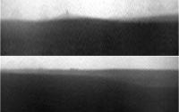
Great map! Here are a couple of Navcam horizon sections from sol 3909 - with a considerable vertical stretch - st show the distant features. I think the sky is clearing a bit, but there's a long way to go.
Phil
-------------------- ... because the Solar System ain't gonna map itself.
Also to be found posting similar content on https://mastodon.social/@PhilStooke Maps for download (free PD: https://upload.wikimedia.org/wikipedia/comm...Cartography.pdf NOTE: everything created by me which I post on UMSF is considered to be in the public domain (NOT CC, public domain) |
|
|
|
|
|
|
Jan 24 2015, 10:16 PM
Post
#85
|
|
|
Senior Member Group: Members Posts: 3516 Joined: 4-November 05 From: North Wales Member No.: 542 |
Thanks fredk for the link to the map, and thanks to the professionals who produced it and made it available. It's exactly what we need. Phil - can you provide a context (or azimuths) for those horizon views? I've been looking hard at one part of the the horizon but I can't locate it in your images.
|
|
|
|
|
Jan 26 2015, 06:58 AM
Post
#86
|
|
|
Senior Member Group: Members Posts: 3516 Joined: 4-November 05 From: North Wales Member No.: 542 |
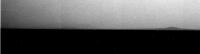
Finally, a pancam view in the right direction . . I think that's Miyamoto on the left, big and very faint with a smaller hill in front of it.
http://qt.exploratorium.edu/mars/opportuni...BXP2351R1M1.JPG |
|
|
|
|
Jan 26 2015, 06:24 PM
Post
#87
|
|
|
Member Group: Members Posts: 148 Joined: 9-August 11 From: Mason, TX Member No.: 6108 |
Phil's stretched images reminded me of something. While Opportunity is near its current "mountaintop" location in dusty conditions, is it possible that at sundown it could image the mountain-shadow phenomenon that visitors to the top of Mauna Loa often can see?
http://darkerview.com/wordpress/?p=8766 The physics being the same on both worlds, I suspect that it could, since the "point" is more of a trick of perspective and viewpoint than of the steepness of the slopes. But perhaps the altitude is not enough to obtain that perspective. -------------------- --
Don |
|
|
|
|
Jan 26 2015, 09:06 PM
Post
#88
|
||
|
Senior Member Group: Members Posts: 3516 Joined: 4-November 05 From: North Wales Member No.: 542 |
I've had a crude go at tweaking brightness and contrast to bring out the outline of Miyamoto.
Attached thumbnail(s)
|
|
|
|
|
|
|
Jan 26 2015, 10:44 PM
Post
#89
|
|
|
Founder Group: Chairman Posts: 14432 Joined: 8-February 04 Member No.: 1 |
QUOTE (MarsInMyLifetime @ Jan 26 2015, 10:24 AM) is it possible that at sundown it could image the mountain-shadow phenomenon that visitors to the top of Mauna Loa often can see? http://pancam.astro.cornell.edu/pancam_ins...847B_P2445.html Doing anything in color much beyond that time will be hard as fringing between filters will dominate the effect. Navcam might be able to pull something off. |
|
|
|
|
Feb 1 2015, 07:47 PM
Post
#90
|
|
|
Member Group: Members Posts: 154 Joined: 21-April 05 From: Rochester, New York, USA Member No.: 336 |
Just curious. Marathon Valley has been a key objective for years and now it's potentially a few days drive away. Are there any other targets of comparable interest within a few months drive? Curious about the next big goal and the overall mission strategy after this.
<edit: sorry this is probably not the place for this discussion, but I am not seeing an obvious way to delete it> ADMIN: No need to delete, we just moved it from the 'map' thread to here.
|
|
|
|
|

|
Lo-Fi Version | Time is now: 2nd May 2024 - 02:46 PM |
|
RULES AND GUIDELINES Please read the Forum Rules and Guidelines before posting. IMAGE COPYRIGHT |
OPINIONS AND MODERATION Opinions expressed on UnmannedSpaceflight.com are those of the individual posters and do not necessarily reflect the opinions of UnmannedSpaceflight.com or The Planetary Society. The all-volunteer UnmannedSpaceflight.com moderation team is wholly independent of The Planetary Society. The Planetary Society has no influence over decisions made by the UnmannedSpaceflight.com moderators. |
SUPPORT THE FORUM Unmannedspaceflight.com is funded by the Planetary Society. Please consider supporting our work and many other projects by donating to the Society or becoming a member. |
|