Opportunity Route Map |

  |
Opportunity Route Map |
 Oct 1 2005, 12:00 PM Oct 1 2005, 12:00 PM
Post
#736
|
|
|
Senior Member  Group: Members Posts: 2998 Joined: 30-October 04 Member No.: 105 |
Yay! The big 6-oh-oh.
  She'll be taking the outcrop path to the right. For the last few Sols (and the next couple of Sols) the landmark has been the near ripple with the crater/depression in the side. The goal for the time being is the large ripple (small dune-?) field on the left side of second frame of your stitch. --Bill -------------------- |
 |
 
|
|
Oct 1 2005, 05:12 PM
Post
#737
|
||
 Senior Member Group: Members Posts: 2492 Joined: 15-January 05 From: center Italy Member No.: 150 |
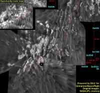
Last route map wasn't easy to assemble, even though panorama includes rover tracks... At the end, I'm almost sure of final, approximate location for Sol599.
As highlighted by Bill, it seems Oppy is following an outcrop zig-zag path (very nevrotic indeed   ); the average SW direction is as expected. ); the average SW direction is as expected.I made also some changes in the route layout and adjusted projections orientation...
Attached thumbnail(s)
-------------------- I always think before posting! - Marco -
|
|
|
|
|
|
|
Oct 1 2005, 05:27 PM
Post
#738
|
|
|
Member Group: Members Posts: 311 Joined: 31-August 05 From: Florida & Texas, USA Member No.: 482 |
Nice piece of detective work, dilo! Seems like progress-made-good towards Payton is only going to be about 60% of total milage? So if Payton is ~100m distant, Oppy's gonna dune-dance for 160m?
Does 15 days seem like a reasonable guess on how long before we near Payton? |
|
|
|
|
Oct 1 2005, 08:14 PM
Post
#739
|
|
|
Solar System Cartographer Group: Members Posts: 10166 Joined: 5-April 05 From: Canada Member No.: 227 |
I just got back from a vacation trip where my internet access was extremely limited... and it is so good to see all this action on Mars. But best of all is these fabulous maps by Dilo and others... I especially like Dilo's amazing results, though. They could hardly have better maps in the planning meetings.
Phil -------------------- ... because the Solar System ain't gonna map itself.
Also to be found posting similar content on https://mastodon.social/@PhilStooke Maps for download (free PD: https://upload.wikimedia.org/wikipedia/comm...Cartography.pdf NOTE: everything created by me which I post on UMSF is considered to be in the public domain (NOT CC, public domain) |
|
|
|
|
Oct 2 2005, 04:46 AM
Post
#740
|
|
|
Senior Member Group: Members Posts: 2492 Joined: 15-January 05 From: center Italy Member No.: 150 |
QUOTE (Phil Stooke @ Oct 1 2005, 08:14 PM) I just got back from a vacation trip where my internet access was extremely limited... and it is so good to see all this action on Mars. But best of all is these fabulous maps by Dilo and others... I especially like Dilo's amazing results, though. They could hardly have better maps in the planning meetings. Phil   thanks for nice words, Phil. However, I must admit that my maps could be strongly improved by using precise orientation infos and even approximante topography (DTM)... So they probably HAVE better maps in the planning meeteng... thanks for nice words, Phil. However, I must admit that my maps could be strongly improved by using precise orientation infos and even approximante topography (DTM)... So they probably HAVE better maps in the planning meeteng... 
-------------------- I always think before posting! - Marco -
|
|
|
|
|
Oct 2 2005, 07:19 AM
Post
#741
|
|
|
Senior Member Group: Moderator Posts: 4279 Joined: 19-April 05 From: .br at .es Member No.: 253 |
QUOTE (dilo @ Oct 1 2005, 07:12 PM) Last route map wasn't easy to assemble, even though panorama includes rover tracks... At the end, I'm almost sure of final, approximate location for Sol599. Are you sure about this map, Dilo? I have my concerns, because there was no drive on sol 599 but just a rear looking 5x1 navcam pano. Imho, we are still at 598 position and the track marks you see on 599 pano are those from 592's drive. |
|
|
|
|
Oct 2 2005, 07:42 AM
Post
#742
|
|
|
Senior Member Group: Members Posts: 2492 Joined: 15-January 05 From: center Italy Member No.: 150 |
QUOTE (Tesheiner @ Oct 2 2005, 07:19 AM) Are you sure about this map, Dilo? I have my concerns, because there was no drive on sol 599 but just a rear looking 5x1 navcam pano. Imho, we are still at 598 position and the track marks you see on 599 pano are those from 592's drive. I must admit, I checked and now I recognize the features East to 598 location!  In fact, as I told, I wasn't sure of my last assembly, so thank you for correction. Pls, disregard my last update and keep checking future updates... -------------------- I always think before posting! - Marco -
|
|
|
|
|
Oct 2 2005, 12:52 PM
Post
#743
|
|
|
Senior Member Group: Members Posts: 2998 Joined: 30-October 04 Member No.: 105 |
I though there were too many zigs-and-zags. Sometimes this "TLAR" seat-of-the-pants navigation can lead to errors. Not being critical, your maps are great.
The "near ripple with the crater/depression in the side" I mentioned earlier is just north of your Sol-599 endpoint. I believe that Oppy is going to pass just North of that landmark on the Westward trek; I have no idea exactly were we will go from there. Great work! --Bill -------------------- |
|
|
|
|
Oct 2 2005, 11:34 PM
Post
#744
|
||
|
Senior Member Group: Members Posts: 2492 Joined: 15-January 05 From: center Italy Member No.: 150 |
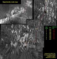
At this point, I cross my fingers before to post this new map...
identifications still hard, I think because we are traversing a field of tall dunes and we have poor visibility of feature in West direction... so, if someone find major incongruences, pls tell me! I changed map layout, re-introducing letters because waypoints identifications are harder in a zig-zag path like this... moreover, I reproduced the path in the MGS insert, making easier identification in the wide scale contest. PS: Bill, thanks for encouraging words PPSS: could you explain "TLAR seat-of-the-pants navigation" meaning?... -------------------- I always think before posting! - Marco -
|
|
|
|
|
|
|
Oct 3 2005, 12:41 AM
Post
#745
|
|
|
Senior Member Group: Members Posts: 2998 Joined: 30-October 04 Member No.: 105 |
Dilo, based on your position for Sol 598 (g), and the proposed drive to Sol 8601 (h), your Map Sol 601a looks about right. Good work.
TLAR is an abbreviation/acronym for "That Looks About Right". "Seat-of-the-pants navigation" is navigation by intuition, or what looks about right. American slang, I forget that we have many readers here that don't understand "foreign slang" like that...  We need to come up with a name for the large dune field ahead (on the left side of your MOC image). Getting by that is going to be the dangerous part of this leg of the journey to Mogollon. --Bill -------------------- |
|
|
|
|
Oct 3 2005, 08:24 AM
Post
#746
|
|
|
Senior Member Group: Moderator Posts: 4279 Joined: 19-April 05 From: .br at .es Member No.: 253 |
QUOTE (dilo @ Oct 2 2005, 06:46 AM) So they probably HAVE better maps in the planning meeteng... (Starting a little break on the annular eclipse observations) I have the feeling that they are doing some sort of polar/vertical projections. Why? If you have a look to the navcam panos taken on sol 601 drive and also on previous sols, sometimes Oppy shot two panos during the drive; the first at middrive and the second (and final) at post-drive. What is the purpose of taking this middrive panorama? My opinion is that it is used to make the same (or similar) projection as Dilo is providing to us. As I already said before, this is the best (if not only) way to track the rover position with the MOC imagery. (Going back outdoor to continue looking the solar eclipse...) |
|
|
|
|
Oct 3 2005, 08:55 AM
Post
#747
|
|
|
Founder Group: Chairman Posts: 14432 Joined: 8-February 04 Member No.: 1 |
They've done that mid-drive navcam mosaic's very rarely - infact I think the last few days with Oppy are the first time I've seen it.
It makes for good mapping of the outcropping, which is obviously an interesting thing to look at. Doug |
|
|
|
|
Oct 3 2005, 10:31 AM
Post
#748
|
|||
|
Senior Member Group: Moderator Posts: 4279 Joined: 19-April 05 From: .br at .es Member No.: 253 |
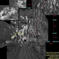
Dilo / Bill,
I was trying to locate similar features between sol 598 and 601 navcam images, and it is was really difficult with just the ahead-looking panorama. Now, the navcam pano looking backwards is at the exploratorium and I think that Oppy drove even more that proposed on Dilo's route map. Here is my "proposal" plotted on sol 598 data. Note that the pictures are heavily compressed to save space/bandwith. If you have your own made panoramas, use them as reference. Comments?
Attached thumbnail(s)
|
||
|
|
|
||
|
Oct 3 2005, 12:05 PM
Post
#749
|
||
|
Senior Member Group: Members Posts: 2833 Joined: 22-April 05 From: Ridderkerk, Netherlands Member No.: 353 |
Here is a Pancam L2 panoramic view from that same area.
Taken on Sol 589. jvandriel
Attached thumbnail(s)
|
|
|
|
|
|
|
Oct 3 2005, 02:04 PM
Post
#750
|
|
|
Senior Member Group: Moderator Posts: 4279 Joined: 19-April 05 From: .br at .es Member No.: 253 |
QUOTE (Tesheiner @ Oct 3 2005, 12:31 PM) Here is my "proposal" plotted on sol 598 data. The middrive panorama from sol 601 (site/drive 62AF) is available too and it seems to confirm the two-leg drive. |
|
|
|
|

|
Lo-Fi Version | Time is now: 23rd May 2024 - 02:37 PM |
|
RULES AND GUIDELINES Please read the Forum Rules and Guidelines before posting. IMAGE COPYRIGHT |
OPINIONS AND MODERATION Opinions expressed on UnmannedSpaceflight.com are those of the individual posters and do not necessarily reflect the opinions of UnmannedSpaceflight.com or The Planetary Society. The all-volunteer UnmannedSpaceflight.com moderation team is wholly independent of The Planetary Society. The Planetary Society has no influence over decisions made by the UnmannedSpaceflight.com moderators. |
SUPPORT THE FORUM Unmannedspaceflight.com is funded by the Planetary Society. Please consider supporting our work and many other projects by donating to the Society or becoming a member. |
|