Ceres High Altitude Mapping Orbit (HAMO), Late summer through fall 2015 |

  |
Ceres High Altitude Mapping Orbit (HAMO), Late summer through fall 2015 |
 Sep 15 2015, 02:56 PM Sep 15 2015, 02:56 PM
Post
#166
|
|
|
Newbie  Group: Members Posts: 2 Joined: 13-June 15 Member No.: 7499 |
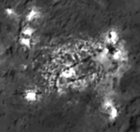
QUOTE (Phil Stooke @ Sep 15 2015, 03:56 PM)  The apparent change in brightness is almost certainly caused by the use of a high pass filter during processing. Why doesn't that filter affect the other spots allso? All the smaller spots are brighter in the higher resolution. Could the elevation angle of the Sunlight (seems lower in the low-res picture) be part of the explanation (illumination and reflection of brighter slopes, like on lonely mountain)? |
 |
 
|
|
Sep 15 2015, 03:12 PM
Post
#167
|
||
 Member Group: Members Posts: 555 Joined: 27-September 10 Member No.: 5458 |
There are lots of factors that are causing differences between those images. Different capture angles will receive differing amounts and positions of reflected light, different solar incidence will change the amount and position of reflected light, different exposure lengths will record the area differently, image compression can play a role, and finally image processing such as the histogram stretch and other filters can greatly change the appearance of the data.
Here's a rough modification of the higher resolution capture to appear more like the previous one.
I could say I'm hopeful that the area at the far right in the survey orbit image is evidence for the 'haze' that disappears in the HAMO image but I think what we are seeing is more related to Dawn being closer and better able to resolve the spots than anything else. Most likely, any images featuring the supposed 'haze' have not been released, unfortunately... -------------------- |
|
|
|
|
|
|
Sep 15 2015, 04:13 PM
Post
#168
|
|
 Senior Member Group: Members Posts: 4246 Joined: 17-January 05 Member No.: 152 |
QUOTE (Michel Uphoff @ Sep 15 2015, 03:56 PM) Why doesn't that filter affect the other spots allso? It looks very much like the longer-exposure image was used for the smaller spots (as it was for most of the new image). Only the largest spots were replaced with the short-exposure image. They may have simply selected by hand which parts of the long-exposure image to replace with the short-exposure image, or perhaps used some semi-automatic selection method. We really can't say much from this new image and have to wait until we see the original two frames. |
|
|
|
|
Sep 15 2015, 05:47 PM
Post
#169
|
|
|
Senior Member Group: Members Posts: 2998 Joined: 30-October 04 Member No.: 105 |
As I said in the caption to the Comparative images of the two timeframes:
QUOTE The upper image is PIA19889 is a HAMO image taken around 21 August 2015 and the lower image is PIA19579 and is a Survey Orbit image taken on 9 June 2015 and are presented at an image scale of 205 meters/pixel. Although the earlier SO image is less clear, similar features can be spotted on both images and over the time span it appears that no significant changes have taken place. Note that the pair of spots on the Eastern side are less prominent in the SO image than in the HAMO image. It may well be that this pair of spots shows decreased activity in the later image, but it might be that this is simply an artifact of NASA compositing the image... https://univ.smugmug.com/Dawn-Mission/Ceres...-11--compar.png And looking closely at the floor of Occator in the HAMO image, I can say that there has been no obvious changes in the 9June to 21Aug time period, although this has been a very active area. --Bill -------------------- |
|
|
|
|
Sep 16 2015, 01:59 AM
Post
#170
|
|
|
Member Group: Members Posts: 555 Joined: 27-September 10 Member No.: 5458 |
-------------------- |
|
|
|
|
Sep 16 2015, 04:10 AM
Post
#171
|
||
|
Member Group: Members Posts: 148 Joined: 9-August 11 From: Mason, TX Member No.: 6108 |
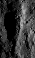
QUOTE (ZLD @ Sep 15 2015, 07:59 PM) Processed enlargement of HAMO 16. This linear structure from that image seems to have a depression along part of its ridge line. It appears to be due to subsidence of whatever material formed the dike in the first place.
-------------------- --
Don |
|
|
|
|
|
|
Sep 16 2015, 09:27 AM
Post
#172
|
||||
 Newbie Group: Members Posts: 11 Joined: 13-May 15 Member No.: 7464 |
QUOTE (MarsInMyLifetime @ Sep 16 2015, 06:10 AM) This linear structure from that image seems to have a depression along part of its ridge line. It appears to be due to subsidence of whatever material formed the dike in the first place.
In the context of SO34 (http://photojournal.jpl.nasa.gov/catalog/PIA19603), it is a part of a ridge, but it even looks as if it could be the central peak of a much wider/less obvious crater. You will have to rotate HAMO16 90 deg counterclockwise to get the same perspective. ZLD: could you please add SO34 to your awesome map?
EDIT: I almost forgot, this is also visible in a different lightning in SO43 (http://photojournal.jpl.nasa.gov/catalog/PIA19616). The flowage features from the crater on the right ridge are more obvious here.
|
|||
|
|
|
|||
|
Sep 16 2015, 12:18 PM
Post
#173
|
|
 Member Group: Members Posts: 423 Joined: 13-November 14 From: Norway Member No.: 7310 |
QUOTE (ZLD @ Sep 16 2015, 03:59 AM) Processed enlargement of HAMO 16. In your enlarged version, it looks very obvious that there are boulders on the floor of the young, intriguing crater; but in the original image, it just barely looks that way. Hm. -------------------- |
|
|
|
|
Sep 16 2015, 01:40 PM
Post
#174
|
|
|
Member Group: Members Posts: 555 Joined: 27-September 10 Member No.: 5458 |
bsharp: I'll try to include this in today's map. The Dawn releases have pretty commonly been occuring between 11h00 and 12h00 CST.
Habukaz: As for the magically appearing boulders, I wouldn't rule out the possibility of noise but most of the released HAMO images seem to be, for whatever reason, just slightly out of focus to begin with so who knows. -------------------- |
|
|
|
|
Sep 16 2015, 02:42 PM
Post
#175
|
|
|
Member Group: Members Posts: 423 Joined: 13-November 14 From: Norway Member No.: 7310 |
I just had a look at the TIFF file, and it seems that JPEG was the culprit. For such fine details, even light JPEG compression can make a big difference, apparently. Lesson learnt.
Pretty sure now that the boulders are real. I hadn't noticed boulders earlier, though I had only been looking at the JPEGs. I can see boulder-like structures in HAMO #6 as well now. -------------------- |
|
|
|
|
Sep 16 2015, 02:51 PM
Post
#176
|
||
|
Senior Member Group: Members Posts: 2998 Joined: 30-October 04 Member No.: 105 |
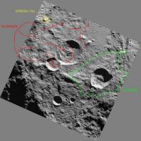
There is so much happening in HO16. An apparent slumpage feature to the west, a mantling terrain flowage feature to the east and on the upper side, a conical hill with a central pit.
And we are getting the "Meh" HAMOs from last month. Think of what the reaallly good stuff shows!!!!  --Bill
Attached thumbnail(s)
-------------------- |
|
|
|
|
|
|
Sep 16 2015, 03:34 PM
Post
#177
|
|
|
Member Group: Members Posts: 555 Joined: 27-September 10 Member No.: 5458 |
No kidding Bill. I think at this point, while the brights spots are tantalizing, Haulani is currently more intriguing to me. Really looking forward to that HAMO image. I will again hope that's what we'll be getting today but I'm not going to hold my breath (not interested in asphyxiating myself really).
Also, the conical hill you noted in your image Bill, there are several others in the area and to me it would seem that they may be related to ancient central crater peaks that have lingered longer than the crater rims. -------------------- |
|
|
|
|
Sep 16 2015, 04:24 PM
Post
#178
|
||
|
Senior Member Group: Members Posts: 1074 Joined: 21-September 07 From: Québec, Canada Member No.: 3908 |
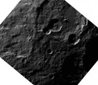
Spectacular slump feature in HAMO17:
(enlarged 3x) |
|
|
|
|
|
|
Sep 16 2015, 04:35 PM
Post
#179
|
|
|
Member Group: Members Posts: 555 Joined: 27-September 10 Member No.: 5458 |
Processed enlargement of HAMO 17.
 Now that we've seen an appreciable number of slumped soil in HAMO, this one seems particularly smooth, with an obvious exception that it was already unique. It seems almost like it just melted away like a lava flow rather than the other seemingly stepped mass wasting at other sites. Imaging map: 
-------------------- |
|
|
|
|
Sep 16 2015, 05:02 PM
Post
#180
|
||
 Senior Member Group: Members Posts: 1887 Joined: 20-November 04 From: Iowa Member No.: 110 |
QUOTE (charborob @ Sep 16 2015, 11:24 AM) Spectacular slump feature in HAMO17:
(enlarged 3x) Seen previously with different lighting in HAMO4 http://www.unmannedspaceflight.com/index.p...st&p=225665 http://photojournal.jpl.nasa.gov/jpeg/PIA19635.jpg |
|
|
|
|
|
|

|
Lo-Fi Version | Time is now: 3rd May 2024 - 12:26 AM |
|
RULES AND GUIDELINES Please read the Forum Rules and Guidelines before posting. IMAGE COPYRIGHT |
OPINIONS AND MODERATION Opinions expressed on UnmannedSpaceflight.com are those of the individual posters and do not necessarily reflect the opinions of UnmannedSpaceflight.com or The Planetary Society. The all-volunteer UnmannedSpaceflight.com moderation team is wholly independent of The Planetary Society. The Planetary Society has no influence over decisions made by the UnmannedSpaceflight.com moderators. |
SUPPORT THE FORUM Unmannedspaceflight.com is funded by the Planetary Society. Please consider supporting our work and many other projects by donating to the Society or becoming a member. |
|