Pluto Surface Observations 1: NH Post-Encounter Phase, 1 Aug 2015- 10 Oct 2015 |

  |
Pluto Surface Observations 1: NH Post-Encounter Phase, 1 Aug 2015- 10 Oct 2015 |
 Sep 25 2015, 07:53 AM Sep 25 2015, 07:53 AM
Post
#436
|
|
 Senior Member  Group: Members Posts: 3648 Joined: 1-October 05 From: Croatia Member No.: 523 |
QUOTE (jccwrt @ Sep 25 2015, 01:40 AM)  Couldn't that just be optical scattering and not the atmosphere? I wouldn't expect the atmosphere to be that bright given how sparse it is. You also wouldn't expect its brightness to be so strongly correlated with the surface limb brightness. -------------------- |
 |
 
|
|
Sep 25 2015, 08:59 AM
Post
#437
|
|
|
Newbie Group: Members Posts: 14 Joined: 25-August 15 Member No.: 7732 |
QUOTE (lars_J @ Sep 24 2015, 09:53 PM) Oh I think you are VASTLY overestimating the slab's height around the surrounding terrain. That would be several times taller than the tallest peak that has been identified. I think you are misreading terrain texture as a steep cliff face. The color version (see below) shows much less illumination difference - especially compare to the surrounding mountains and craters. Not a steep cliff at all, instead it looks like a very gradual slope. The color version has been processed in a way that makes the cliff less obvious, but if you look carefully at the shadow beyond the cliff base I have marked in orange, you can see that the surface features that are illuminated outside the shadow continue into the shadow. The shadow is real. I can't be exactly sure how high the cliff is or therefore how thick the beached slab is. Even if there has been significant slumping of the cliff, the slab has still got to be at least 4 km high. That is pretty amazing. -------------------- |
|
|
|
|
Sep 25 2015, 10:08 AM
Post
#438
|
|
 Member Group: Members Posts: 423 Joined: 13-November 14 From: Norway Member No.: 7310 |
QUOTE (exoplanet @ Sep 25 2015, 02:34 AM) So this is Methane Ice and not Nitrogen Ice . . .I am puzzled . . . so what is being pushed onto the surface is methane rather than Nitrogen? The map released was a methane map. It shows where the methane is, it doesn't say that any of it is all methane. Any methane could also just be a thin surface layer. QUOTE (alan @ Sep 25 2015, 01:54 AM) If the lorri-rider is the 120m/px my guess of its path is pretty close. What I have labeled as 70m/px is probably the pass previous to the highest resolution pass as it is probably a rider of the MVIC image released last week. Looking at NASA's eyes on Pluto yesterday I saw another pass running across the chaos terrain (oops make that the north edge of Sputnik Planum) then east-northeast across some of the smoother terrain. ETA: If someone is interested at checking Eyes on Pluto, the 250 m/pixel pass is the one beginning at 6:49 EDT, what I have (mis)labeled as 70m/px starts at 7:36 EDT, the 120/px starts at 7:23, the east northeast pass begins at 7:30 EDT (and may catch Charon for a Kodak Moment), and the highest resolution pass begins at 8:04 EDT. http://www.unmannedspaceflight.com/index.p...st&p=226672 I'd advice you to use Machi's tables, they contain all/most LORRI and MVIC imaging sequences around the time of closest approach. Emily also has an overview of the LORRI imaging sequences in an image here. The highest-resolution images released yesterday are almost certainly from the M_PAN_1 sequence (which is indeed the sequence with ~ 120 m/pixel resolution), or a sequence directly before it that we don't have the name of. What you have labelled the 70 m/pixel track corresponds to the P_MVIC_LORRI_CA sequence, which should be the highest-resolution imaging sequence of Pluto we'll get (it faces some competition from the P_HIPHASE_HIRES sequence, which are the LORRI images taken around the same time as last week's MVIC sunset panorama). (the global MVIC image from yesterday would appear to be P_Color_2 at ~ 650 m/pixel, per what John Spencer wrote about per-pixel resolution being multiplied by 2 for release captions) -------------------- |
|
|
|
|
Sep 25 2015, 10:14 AM
Post
#439
|
|
 IMG to PNG GOD Group: Moderator Posts: 2251 Joined: 19-February 04 From: Near fire and ice Member No.: 38 |
QUOTE (Charles Astro @ Sep 25 2015, 08:59 AM) The color version has been processed in a way that makes the cliff less obvious There is no detailed information on exactly how the color version was processed. Secondly, even in the grayscale version there is nothing that is obviously a cliff. Pluto has very large albedo variations and you need stereo imagery to get accurate topographic information, including information on whether there's a cliff there. As lars_j said, you are probably vastly overestimating things. This is still a limited data set that's easy to overinterpret. |
|
|
|
|
Sep 25 2015, 01:23 PM
Post
#440
|
|
|
Junior Member Group: Members Posts: 23 Joined: 24-August 07 Member No.: 3405 |
This forum might break when the 70m/pix set comes out.
|
|
|
|
|
Sep 25 2015, 01:44 PM
Post
#441
|
|
 Member Group: Members Posts: 555 Joined: 27-September 10 Member No.: 5458 |
QUOTE (jccwrt @ Sep 24 2015, 06:40 PM) Couldn't that just be optical scattering and not the atmosphere? I wouldn't expect the atmosphere to be that bright given how sparse it is. I certainly wouldn't rule There does appear to be some delicate structure to the bloom however.  Maybe it is one part optical scattering, one part haze layers. --Edited for clarity. -------------------- |
|
|
|
|
Sep 25 2015, 02:25 PM
Post
#442
|
|
 Member Group: Members Posts: 345 Joined: 2-May 05 Member No.: 372 |
I just ordered myself a 40"x40" poster print of the full disc image. Couldn't resist. Using my upcoming birthday as an excuse.

|
|
|
|
|
Sep 25 2015, 03:34 PM
Post
#443
|
||
 Senior Member Group: Members Posts: 4250 Joined: 17-January 05 Member No.: 152 |
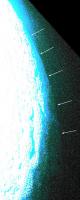
QUOTE (ugordan @ Sep 25 2015, 08:53 AM) You also wouldn't expect its brightness to be so strongly correlated with the surface limb brightness. Agreed, so I think this is probably mostly optical scattering. However, I was surprized at how bright the atmosphere was in last week's crescent image relative to the sunlit surface. Of course this new image is from a completely different phase angle, so maybe some of the atmospheric guys could chime in as to how likely the phase function would imply observable atmosphere in the full disk shot. Anyway, we can pretty clearly see a portion of the disk beyond the terminator lit by scattered light in the new image:
The upper portion (top three arrows in my pic) appears quite strongly blue, which might suggest that the atmospheric scattering is blue. However, we'd need to see the original data to be sure. It might simply be that the response of the blue channel is greater than the other channels at low illumination levels, or that the correct relative channel weights haven't been maintained at low illumination levels in making the composite. |
|
|
|
|
|
|
Sep 25 2015, 03:52 PM
Post
#444
|
|
|
Member Group: Members Posts: 555 Joined: 27-September 10 Member No.: 5458 |
It could be that the NIR channel was set to the green channel. That would be the most likely to capture the faint light at the terminator no? It just seemed strange that there wasn't any apparent red signatures in the bloom if it is simply optical scattering unless, as mentioned, the blue channel is more sensitive.
-------------------- |
|
|
|
|
Sep 25 2015, 04:20 PM
Post
#445
|
|
|
Senior Member Group: Members Posts: 2998 Joined: 30-October 04 Member No.: 105 |
QUOTE (ZLD @ Sep 25 2015, 08:44 AM) I certainly wouldn't rule There does appear to be some delicate structure to the bloom however. --Edited for clarity. I noticed that same "noontime haze" when I tweaked that new image from NH. Turning the Tweakometer knob up higher there are other "layers" of detail much higher. I'll assume that this _may be_ an artifact of the preprocessing done by NH before posting. FWIW. --Bill -------------------- |
|
|
|
|
Sep 25 2015, 04:23 PM
Post
#446
|
|
 Member Group: Members Posts: 684 Joined: 24-July 15 Member No.: 7619 |
QUOTE (lars_J @ Sep 24 2015, 08:47 PM) Here is the snakeskin terrain: The terrain looks like the west coast of {Iceland} Greenland, viewed from 15 miles up. Edit - sorry, wrong island... |
|
|
|
|
Sep 25 2015, 05:07 PM
Post
#447
|
||
 Member Group: Members Posts: 714 Joined: 3-January 08 Member No.: 3995 |
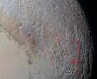
The snake skin and arcuate depressions (some marked in red) seem to coincide with the eastern lobe of Tombaugh Regio (and Tartarus Dorsa):
Do the arcs 'transition' into the pits to the north, or are they completely different in nature? Edit: These features may very well extend around much of Pluto's equator. They are absent from Sputnik and areas to the west possibly because other materials (plastic nitrogen, tholin mantle, etc.) preclude their formation. Since the steep faces of the arcuate depressions all face south, their orientation could be due to Pluto's asymmetrical seasons. Working out the thermodynamics of the yearly cycle is a bit above my pay grade, though.  The strongly-defined striations of the snake skin could reflect some aspects of the ice fabric. Perhaps some other process (e.g. tectonic movement) could enhance its formation. |
|
|
|
|
|
|
Sep 25 2015, 05:11 PM
Post
#448
|
|
|
Member Group: Members Posts: 137 Joined: 16-June 15 Member No.: 7507 |
QUOTE (Charles Astro @ Sep 24 2015, 09:50 PM) Note also that the Sputnik Planum ice appears to be methane rich so the whole debate about "whether water ice will float on nitrogen ice?" is the wrong question. "Rich" is, of course, a relative term - I don't think anyone's saying that these aren't overwhelmingly nitrogen ice. Nor do I think anyone expected any of the ices to be devoid in other materials. We already know that Sputnik is, for example, also rich in carbon monoxide which, like nitrogen and unlike methane, is dense both as a liquid and solid. Bur as for bulk materials, I haven't seen anything from the team suggested that, as for the bulk, that it's predominantly anything but nitrogen. If it were in any large part methane, Pluto's atmosphere would be too. Methane sublimes easier than nitrogen. |
|
|
|
|
Sep 25 2015, 05:22 PM
Post
#449
|
|
|
Member Group: Members Posts: 137 Joined: 16-June 15 Member No.: 7507 |
QUOTE (HSchirmer @ Sep 25 2015, 04:23 PM) The terrain looks like the west coast of Iceland, viewed from 15 miles up. I'm not sure what you mean. I assume you mean Vestfirðir (northwest), but it doesn't resemble that at all to me. The glacial-cut valleys don't at all run parallel, they run downslope. To me it looks like giant-scale pahoehoe. Though I would be shocked if the cause was anything even remotely resembling that. If I had to guess, I'd guess that it's the same cause that's believed to cause comets to develop "necks" - ridges = shadows = more pronounced temperature differences over the course of a day = greater cracking = greater sublimation. But I wouldn't put too much confidence in that hypothesis either... |
|
|
|
|
Sep 25 2015, 05:45 PM
Post
#450
|
||
|
Junior Member Group: Members Posts: 80 Joined: 14-February 04 Member No.: 32 |
This is how I imagine the "snakeskin" or "dragonscale" terrain looking from ground level. But I'm probably way off.

Attached thumbnail(s)
-------------------- - Lars
|
|
|
|
|
|
|

|
Lo-Fi Version | Time is now: 4th June 2024 - 04:48 AM |
|
RULES AND GUIDELINES Please read the Forum Rules and Guidelines before posting. IMAGE COPYRIGHT |
OPINIONS AND MODERATION Opinions expressed on UnmannedSpaceflight.com are those of the individual posters and do not necessarily reflect the opinions of UnmannedSpaceflight.com or The Planetary Society. The all-volunteer UnmannedSpaceflight.com moderation team is wholly independent of The Planetary Society. The Planetary Society has no influence over decisions made by the UnmannedSpaceflight.com moderators. |
SUPPORT THE FORUM Unmannedspaceflight.com is funded by the Planetary Society. Please consider supporting our work and many other projects by donating to the Society or becoming a member. |
|