ExoMars - Schiaparelli landing |

  |
ExoMars - Schiaparelli landing |
 Oct 27 2016, 12:43 PM Oct 27 2016, 12:43 PM
Post
#121
|
|
|
Junior Member  Group: Members Posts: 78 Joined: 20-September 14 Member No.: 7261 |
QUOTE (mcaplinger @ Oct 26 2016, 10:50 PM)  Radar is essential for Viking or any Mars lander that has to do anything based on altitude, as the altitude relative to the ground can't be determined any other way. There's always laser altimeters for altitude and doppler Lidar for relative velocity. Might be worth it for the 2020 surface platform to check into what's available, especially inhouse with ESA members and associates. OPTEL-D with AIM heritage comes to mind as a family of something that could possibly be further downsized to a sufficiently low footprint. |
 |
 
|
|
Oct 27 2016, 01:25 PM
Post
#122
|
|
|
Senior Member Group: Members Posts: 2346 Joined: 7-December 12 Member No.: 6780 |
I'd think, they'll "simply" fix the glitch(es) or parameter settings, without fundamental changes of the design.
Edit: Altitude and veolcity of the EDM were determined by radar: QUOTE The Radar Altimeter facilitates four antennas interconnected by a switch matrix supporting a unique transmitting chain and a unique reception chain. One antenna is dedicated to range measurements while the other three are in use for velocity measurements.
|
|
|
|
|
Oct 27 2016, 04:20 PM
Post
#123
|
|
|
Senior Member Group: Members Posts: 2083 Joined: 13-February 10 From: Ontario Member No.: 5221 |
HiRISE images out : http://www.jpl.nasa.gov/news/news.php?feature=6663 Definitely heat shield separation, but a strange streak going east of the lander crash.
|
|
|
|
|
Oct 27 2016, 04:29 PM
Post
#124
|
|
|
Senior Member Group: Members Posts: 2511 Joined: 13-September 05 Member No.: 497 |
QUOTE (katodomo @ Oct 27 2016, 04:43 AM) There's always laser altimeters for altitude and doppler Lidar for relative velocity. Radar is an extremely robust and mature technology and the larger beam footprint and longer wavelength can be an advantage. The landing applications for lidar I know of are for terrain hazard avoidance, not altitude/velocity determination per se, for example https://www-robotics.jpl.nasa.gov/publicati...aejJGCD2002.pdf AFAIK, every successful Mars lander (and Moon lander, for that matter) has used radar. -------------------- Disclaimer: This post is based on public information only. Any opinions are my own.
|
|
|
|
|
Oct 27 2016, 05:30 PM
Post
#125
|
|
 Senior Member Group: Members Posts: 2530 Joined: 20-April 05 Member No.: 321 |
That is definitely a strange streak. Maybe that's the mini-version of a crater ray: The splash of some small-scale debris from the impact site. Another thought: Perhaps that's a location where a small, random feature in the sub-dust topography had less dust adhering to it. The smoothness of the curve, however, doesn't look like typical rock morphology on that scale. Maybe the impact stirred up a mini dust devil?
|
|
|
|
|
Oct 27 2016, 08:30 PM
Post
#126
|
|
 Senior Member Group: Members Posts: 1423 Joined: 26-July 08 Member No.: 4270 |
It could be that a pressurised tank was let free in the impact and the curved streak represents the path the tank took while it was depressurising. Just throwing ideas out there, I doubt we'll ever know for sure.
-------------------- -- Hungry4info (Sirius_Alpha)
|
|
|
|
|
Oct 28 2016, 12:06 AM
Post
#127
|
|
|
Member Group: Members Posts: 507 Joined: 10-September 08 Member No.: 4338 |
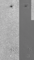
http://photojournal.jpl.nasa.gov/figures/PIA21130_fig2.jpg
There is no sign of the curved "tail" in the CTX image taken last week, so it may have developed since then from debris or disturbed soil blown by the wind. |
|
|
|
|
Oct 28 2016, 01:36 AM
Post
#128
|
||
|
Member Group: Members Posts: 507 Joined: 10-September 08 Member No.: 4338 |
This is a comparison of the CTX and HIRISE images as best I can match them by the eye. I guess the tail could be lost by the low resolution. There might also be some dispersion of the debris in the time between the images. |
|
|
|
|
|
|
Oct 28 2016, 01:38 AM
Post
#129
|
|
|
Senior Member Group: Members Posts: 1423 Joined: 26-July 08 Member No.: 4270 |
There's also no signs in the CTX of the rather prominent craters just west of, and south of, the impact site. Either those craters are also a few days old or the CTX image doesn't really have the resolution and/or signal-to-noise ratio to see such finer details.
-------------------- -- Hungry4info (Sirius_Alpha)
|
|
|
|
|
Oct 28 2016, 05:58 AM
Post
#130
|
|
 Member Group: Members Posts: 568 Joined: 20-April 05 From: Silesia Member No.: 299 |
QUOTE (Hungry4info @ Oct 27 2016, 08:30 PM) It could be that a pressurised tank was let free in the impact and the curved streak represents the path the tank took while it was depressurising. I think this is the right solution. This may be a trace of a rotating and ruptured tank. This explains the arc. -------------------- Free software for planetary science (including Cassini Image Viewer).
http://members.tripod.com/petermasek/marinerall.html |
|
|
|
|
Oct 28 2016, 07:37 AM
Post
#131
|
|
|
Member Group: Members Posts: 282 Joined: 18-June 04 Member No.: 84 |
Little snippets of information still coming out, one saying the lander swung too much while on the parachute confusing the the altimeter causing the computer to look for radar which wasnt on (maybe). Computer triggers remaining decent sequences, even science instruments turned on, thinking it had landed !
|
|
|
|
|
Oct 29 2016, 02:05 PM
Post
#132
|
|
 Member Group: Members Posts: 290 Joined: 29-December 05 From: Ottawa, ON Member No.: 624 |
QUOTE (marsophile @ Oct 27 2016, 05:06 PM) http://photojournal.jpl.nasa.gov/figures/PIA21130_fig2.jpg There is no sign of the curved "tail" in the CTX image taken last week, so it may have developed since then from debris or disturbed soil blown by the wind. Could the lack of curved tail be explained by different lighting angles between the two images? |
|
|
|
|
Oct 29 2016, 04:28 PM
Post
#133
|
|
|
Solar System Cartographer Group: Members Posts: 10154 Joined: 5-April 05 From: Canada Member No.: 227 |
It is a resolution issue, but I don't agree that it is not visible in CTX. There is a dark pixel in CTX at exactly the right place.
Phil -------------------- ... because the Solar System ain't gonna map itself.
Also to be found posting similar content on https://mastodon.social/@PhilStooke Maps for download (free PD: https://upload.wikimedia.org/wikipedia/comm...Cartography.pdf NOTE: everything created by me which I post on UMSF is considered to be in the public domain (NOT CC, public domain) |
|
|
|
|
Oct 29 2016, 06:56 PM
Post
#134
|
|
|
Member Group: Members Posts: 149 Joined: 18-June 08 Member No.: 4216 |
Could someone cognisant speculate on how hydrazine might behave if exposed to martian surface conditions?
For instance, would it burn, explode, quickly evaporate, or linger? |
|
|
|
|
Oct 29 2016, 08:08 PM
Post
#135
|
|
|
Senior Member Group: Members Posts: 2083 Joined: 13-February 10 From: Ontario Member No.: 5221 |
MSL's hazcam showed the skycrane explosion as a big plume, but there wasn't enough detail to tell if it was smoke from some chemical reaction/combustion or just a dust cloud from the impact itself. They obviously didn't want to risk exposure to toxic hardware to take a closer look with the rover though....
|
|
|
|
|

|
Lo-Fi Version | Time is now: 1st May 2024 - 09:51 AM |
|
RULES AND GUIDELINES Please read the Forum Rules and Guidelines before posting. IMAGE COPYRIGHT |
OPINIONS AND MODERATION Opinions expressed on UnmannedSpaceflight.com are those of the individual posters and do not necessarily reflect the opinions of UnmannedSpaceflight.com or The Planetary Society. The all-volunteer UnmannedSpaceflight.com moderation team is wholly independent of The Planetary Society. The Planetary Society has no influence over decisions made by the UnmannedSpaceflight.com moderators. |
SUPPORT THE FORUM Unmannedspaceflight.com is funded by the Planetary Society. Please consider supporting our work and many other projects by donating to the Society or becoming a member. |
|