Opportunity Route Map |

  |
Opportunity Route Map |
 Oct 7 2005, 08:43 PM Oct 7 2005, 08:43 PM
Post
#781
|
|
 Senior Member  Group: Members Posts: 2488 Joined: 17-April 05 From: Glasgow, Scotland, UK Member No.: 239 |
QUOTE (abalone @ Oct 7 2005, 01:56 PM) Could have kept going, but that sand (dust?) is soft  Actually, I'd say it looks firmer (shallower?) than Purgatory... -------------------- Remember: Time Flies like the wind - but Fruit Flies like bananas!
|
 |
 
|
|
Oct 8 2005, 09:43 AM
Post
#782
|
|
|
Senior Member Group: Members Posts: 2998 Joined: 30-October 04 Member No.: 105 |
My mental image of the sand is that it is fluffy and compactable, much like newfallen snow. I would love to see cross sections of some shelby tube samples of that material. I imagine that once we get to the higher relief parts of this ripple field we will eventally encounter a fresh slump and we'll be able to examine an undisturbed cross section.
--Bill -------------------- |
|
|
|
|
Oct 10 2005, 06:36 AM
Post
#783
|
|
 Senior Member Group: Members Posts: 2492 Joined: 15-January 05 From: center Italy Member No.: 150 |
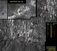
Based on Sol608 imagery, Opyy covered almost 11m in West direction (updated route map will arrive soon)
-------------------- I always think before posting! - Marco -
|
|
|
|
|
Oct 11 2005, 04:00 AM
Post
#784
|
||
|
Senior Member Group: Members Posts: 2492 Joined: 15-January 05 From: center Italy Member No.: 150 |
Not so soon (Forum connectivity issues
 ): ):
Attached thumbnail(s)
-------------------- I always think before posting! - Marco -
|
|
|
|
|
|
|
Oct 12 2005, 08:01 AM
Post
#785
|
|
|
Member Group: Members Posts: 236 Joined: 21-June 05 Member No.: 417 |
I wonder why the Spirit traverse maps are updated regularly, while the Opportunity maps are still at sol 566
http://marsrovers.jpl.nasa.gov/mission/traverse_maps.html |
|
|
|
|
Oct 12 2005, 11:10 AM
Post
#786
|
|
|
Member Group: Members Posts: 153 Joined: 11-December 04 Member No.: 120 |
http://www.spacedaily.com/news/mars-mers-05zzzzh.html
Interesting update! They did plan for a 45 meter drive, but Oppy stopped when slippage exceeded 40%. 45 meter in this sort of terrain seems pretty impressive to me. Note: we're in restricted (low budget) mode again. |
|
|
|
|
Oct 12 2005, 12:59 PM
Post
#787
|
|
 Member Group: Members Posts: 510 Joined: 17-March 05 From: Southeast Michigan Member No.: 209 |
QUOTE (general @ Oct 12 2005, 04:01 AM) I wonder why the Spirit traverse maps are updated regularly, while the Opportunity maps are still at sol 566 They've probably switched to using Dilo's maps 
-------------------- --O'Dave
|
|
|
|
|
Oct 13 2005, 07:42 AM
Post
#788
|
|
|
Member Group: Members Posts: 236 Joined: 21-June 05 Member No.: 417 |
Opportunity traverse maps update
(to sol 591) http://marsrovers.jpl.nasa.gov/mission/tm-...nity/index.html |
|
|
|
|
Oct 14 2005, 12:37 AM
Post
#789
|
|
 Senior Member Group: Moderator Posts: 2262 Joined: 9-February 04 From: Melbourne - Oz Member No.: 16 |
QUOTE (general @ Oct 13 2005, 05:42 PM) Opportunity traverse maps update (to sol 591) http://marsrovers.jpl.nasa.gov/mission/tm-...nity/index.html Gosh, how poor is that when compared to Dilo's maps! 
-------------------- |
|
|
|
|
Oct 15 2005, 04:39 AM
Post
#790
|
|
 Senior Member Group: Admin Posts: 4763 Joined: 15-March 05 From: Glendale, AZ Member No.: 197 |
-------------------- If Occam had heard my theory, things would be very different now.
|
|
|
|
| Guest_Myran_* |
Oct 16 2005, 01:23 PM
Post
#791
|
|
Guests |
So Opportunity driving today? Guess these from yesterday then, wonderful rocks I like one of the first kind below in my garden!
 Seens to be another bluberry on stalks rock. http://qt.exploratorium.edu/mars/opportuni...JLP2545L6M1.JPG Sediments and a LOT of blueberries. http://qt.exploratorium.edu/mars/opportuni...JLP2543L7M1.JPG |
|
|
|
|
Oct 18 2005, 11:34 PM
Post
#792
|
||
|
Senior Member Group: Members Posts: 2492 Joined: 15-January 05 From: center Italy Member No.: 150 |
Sorry for absence in the last days (I had some HW troubles...). Seems someone missed my maps
 . .Oppy is now heading NE, maybe to avoid the big dunes...
Attached thumbnail(s)
-------------------- I always think before posting! - Marco -
|
|
|
|
|
|
|
Oct 19 2005, 02:55 AM
Post
#793
|
||
|
Senior Member Group: Members Posts: 1636 Joined: 9-May 05 From: Lima, Peru Member No.: 385 |
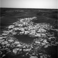
Below picture is a good avenue to approach to rim and there there is outcrop as way to go along the rim.
Rodolfo
Attached thumbnail(s)
|
|
|
|
|
|
|
Oct 19 2005, 03:13 AM
Post
#794
|
|
 Senior Member Group: Members Posts: 2228 Joined: 1-December 04 From: Marble Falls, Texas, USA Member No.: 116 |
Dilo: Your route map updates have certainly been missed by more than one of us. I'm glad to hear that you have apparently conquered your HW problems and are back.
I really wanted to see an updated map today, and there it was, as if delivered by an angel. Welcome back. -------------------- ...Tom
I'm not a Space Fan, I'm a Space Exploration Enthusiast. |
|
|
|
|
Oct 19 2005, 08:04 AM
Post
#795
|
||
|
Senior Member Group: Moderator Posts: 4279 Joined: 19-April 05 From: .br at .es Member No.: 253 |
Welcome back Dilo.
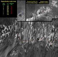
> Seems someone missed my maps. I think everybody missed you maps! Thanks for the update.  While you were offline I was updating my own route map "on the blind". I checked it against your last update and my guesses for sols 615 and 616 almost fit with yours. Just a very minor issue wrt 616 position: I think the point you indicate on the top right corner picture should be a little bit westward.
|
|
|
|
|
|
|

|
Lo-Fi Version | Time is now: 27th May 2024 - 12:44 AM |
|
RULES AND GUIDELINES Please read the Forum Rules and Guidelines before posting. IMAGE COPYRIGHT |
OPINIONS AND MODERATION Opinions expressed on UnmannedSpaceflight.com are those of the individual posters and do not necessarily reflect the opinions of UnmannedSpaceflight.com or The Planetary Society. The all-volunteer UnmannedSpaceflight.com moderation team is wholly independent of The Planetary Society. The Planetary Society has no influence over decisions made by the UnmannedSpaceflight.com moderators. |
SUPPORT THE FORUM Unmannedspaceflight.com is funded by the Planetary Society. Please consider supporting our work and many other projects by donating to the Society or becoming a member. |
|