Juno perijove 6, May 19, 2017 |

  |
Juno perijove 6, May 19, 2017 |
 May 25 2017, 03:49 AM May 25 2017, 03:49 AM
Post
#46
|
|
|
Junior Member  Group: Members Posts: 94 Joined: 22-March 06 Member No.: 722 |
Can only echo thanks to the Juno team and to everyone else working on and supplying this astounding imagery.
My jaw has literally been hanging open this whole thread. -------------------- Mayor: Er, Master Betty, what is the Evil Council's plan?
Master Betty: Nyah. Haha. It is EVIL, it is so EVIL. It is a bad, bad plan, which will hurt many... people... who are good. I think it's great that it's so bad. -Kung Pow: Enter the Fist |
 |
 
|
|
May 25 2017, 03:22 PM
Post
#47
|
|
|
Member Group: Members Posts: 923 Joined: 10-November 15 Member No.: 7837 |
I have updated the following portrait from Perijove 06
   Excellent work by Bjorn & Justin! So great to see Jupiter at this level of detail... I will endeavour to tread gently. -------------------- |
|
|
|
|
May 25 2017, 05:14 PM
Post
#48
|
|||
 IMG to PNG GOD Group: Moderator Posts: 2250 Joined: 19-February 04 From: Near fire and ice Member No.: 38 |
As I mentioned previously, these latest JunoCam images are awesome. I took a fairly detailed look at one of the images I posted earlier with particular attention to cloud elevation differences. First an unusual image. This is a perfectly flat DEM with several spikes - their shadows show the direction of sunlight in one of the JunoCam images I posted earlier:
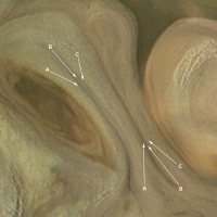
And here is the corresponding JunoCam image. This is one of the images I posted earlier but here I have added some annotations:
A. Bright, high altitude clouds that usually seem to be isolated or to occur in small clusters. B. These clouds are similar to (A) in color and altitude. But unlike (A) they appear elongated, probably parallel to the wind direction. At least in some cases they indicate high wind speeds - clouds like these are visible at lower resolution in Voyager images showing the northeast periphery of the Great Red Spot where the wind speed is very high. C. I suspect that here we are seeing the darker and lower cloud deck through tenuous and mostly transparent high altitude clouds. This is more obvious when looking at the red channel only. D and E. Here JunoCam may have directly observed/imaged the elevation difference between the dark clouds and the less dark clouds south of the 'color/brightness transition'. Areas indicated by (D) appear slightly darker than areas indicated by (E). When taking into account the direction of the shadows in the DEM/spike shadow render above, the areas indicated by (D) may be in shadow caused by the brighter clouds south of the brightness/color transitions while the areas indicated by (E) are not in shadow. F. These clouds seem somewhat similar to (A) but they occur in far bigger clusters. Apparently they also might be at a slightly lower altitude - this is not obvious though. G. Possible shadows hinting at elevation differences but color/brightness variations are also a possibility. Features like this are very common. |
||
|
|
|
||
|
May 25 2017, 05:33 PM
Post
#49
|
|
 Senior Member Group: Members Posts: 1628 Joined: 5-March 05 From: Boulder, CO Member No.: 184 |
Superb image processing and analysis. Great to see both enhanced and unenhanced/realistic versions to get the complete picture. Some first reactions - if I have the larger scale context right:
The dark areas next to D/E look like the IR hot spots at the edge of a belt. The shadow in D agrees with my subjective impression of the brighter laminar appearing clouds being higher and overlaying the darker adjacent clouds. G looks like cloud brightness variations to me. These narrow strands look similar even in differing orientations? "A" features clearly have high cloud tops. I wonder if their bases are low enough to tap into the water vapor layers, helping to give enough opacity to yield the brighter white color. The more true color images suggest these tops may still be below some of the high altitude haze. This haze is yet thin enough to have distinct shadows visible. It seems there's a narrow range of haze optical thickness that allows this type of visibility. -------------------- Steve [ my home page and planetary maps page ]
|
|
|
|
|
May 25 2017, 07:47 PM
Post
#50
|
|
|
Senior Member Group: Members Posts: 2346 Joined: 7-December 12 Member No.: 6780 |
For completeness, a few hours ago I've uploaded revised #122, and #123, after fixing the overflow for saturated pixels.
The first version of the PJ06 flyby animation is completed, too. It's now mostly a matter of upload bandwidth. I'll try an upload to youtube, as well as a first subset of zipped stills to the junocam.pictures webspace, and intend to provide links in about two or three hours. The zipped stills will be 2.34 GB, more than I can upload before next week. |
|
|
|
|
May 25 2017, 09:54 PM
Post
#51
|
||
|
Member Group: Members Posts: 306 Joined: 4-October 14 Member No.: 7273 |
QUOTE (Bjorn Jonsson @ May 25 2017, 11:14 AM)  And here is the corresponding JunoCam image. This is one of the images I posted earlier but here I have added some annotations:
A. Bright, high altitude clouds that usually seem to be isolated or to occur in small clusters. B. These clouds are similar to (A) in color and altitude. But unlike (A) they appear elongated, probably parallel to the wind direction. At least in some cases they indicate high wind speeds - clouds like these are visible at lower resolution in Voyager images showing the northeast periphery of the Great Red Spot where the wind speed is very high. C. I suspect that here we are seeing the darker and lower cloud deck through tenuous and mostly transparent high altitude clouds. This is more obvious when looking at the red channel only. D and E. Here JunoCam may have directly observed/imaged the elevation difference between the dark clouds and the less dark clouds south of the 'color/brightness transition'. Areas indicated by (D) appear slightly darker than areas indicated by (E). When taking into account the direction of the shadows in the DEM/spike shadow render above, the areas indicated by (D) may be in shadow caused by the brighter clouds south of the brightness/color transitions while the areas indicated by (E) are not in shadow. F. These clouds seem somewhat similar to (A) but they occur in far bigger clusters. Apparently they also might be at a slightly lower altitude - this is not obvious though. G. Possible shadows hinting at elevation differences but color/brightness variations are also a possibility. Features like this are very common. Going to make some interested-layman interpretations of the meteorology here. One observation is that the two largest A-type clouds seem to be found at eddy inflection points, right where the white clouds meet the brown clouds. I wonder if these might be supercell-like convective systems that are popping up along the boundary of white and brown clouds, and whose development is aided by favorable upper level conditions created by air diverging as it rounds the inflection point of the eddy. F-type clouds seem to be more embedded within the local flow and are vaguely oriented in "streets" parallel to the flow direction. These are kind of reminiscent of the cloud streets that tend to form in the dry slot of a mature low-pressure system, or in clusters of multicell convection in strong upper level wind regimes where the updrafts tend to form trains. B-type clouds look like cirrus streaks formed getting blown off the tops of the more intense convective clouds, and if you look closely at the A-type cloud clusters near the center of the image, you can see some of these streaks beginning to form as elongated cloudtops on individual convective cells. Maybe a more clear example of what Bjorn is getting at with point C can be seen just to the right of the F at left center. There is an extremely dark brown cloud rotating around the top of the eddy that has an apparently sharp edge, but if you look closely you can see that it continues underneath the lighter clouds. (Not at a computer where I can highlight this but if anyone is having issues seeing what I'm talking about I'll try to have something up within a day) |
|
|
|
|
|
|
May 25 2017, 10:09 PM
Post
#52
|
|
|
Senior Member Group: Members Posts: 2346 Joined: 7-December 12 Member No.: 6780 |
PJ-06 flyby movie, first release:
- on youtube - AVI download link (37 MB) - MOV download link (600 MB). |
|
|
|
|
May 26 2017, 03:43 AM
Post
#53
|
|
|
Member Group: Members Posts: 923 Joined: 10-November 15 Member No.: 7837 |
Another updated portrait...
 Details...    -------------------- |
|
|
|
|
May 26 2017, 04:11 AM
Post
#54
|
|
|
Senior Member Group: Members Posts: 2346 Joined: 7-December 12 Member No.: 6780 |
|
|
|
|
|
May 26 2017, 01:27 PM
Post
#55
|
|
|
Member Group: Members Posts: 923 Joined: 10-November 15 Member No.: 7837 |
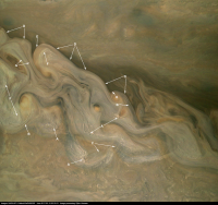
Here is a preview of the sequence Gerald shared... upscaled, rotated and put through a 12 step batch process.
Click thru for a video...  I extended the length of the content x3 and I'm still deciding how to blend between jump cuts as well as tracking the full crescent to avoid linear cuts. -------------------- |
|
|
|
|
May 27 2017, 04:07 AM
Post
#56
|
|
|
Junior Member Group: Members Posts: 59 Joined: 4-July 08 Member No.: 4251 |
QUOTE (GS_Brazil @ May 24 2017, 07:38 AM) What's the size of these 'pileus-like' cottonwool clouds? Scott Bolton said "around 50 km" several times during the press conference. So, about the size of a major US city's metro sprawl, and twice as big as the average thunderstorm on Earth. |
|
|
|
|
May 28 2017, 04:25 PM
Post
#57
|
||
|
IMG to PNG GOD Group: Moderator Posts: 2250 Joined: 19-February 04 From: Near fire and ice Member No.: 38 |
QUOTE (scalbers @ May 25 2017, 05:33 PM) G [in the annotated image I posted earlier - BJ] looks like cloud brightness variations to me. These narrow strands look similar even in differing orientations? From the image it is not clear to me exactly what this is - brightness variations, differences in cloud altitude or even both. What I had in mind is illustrated in more detail below. This is a section of my original image enlarged by a factor of 3:
A. Slightly darkened. Tilted away from the sun? B. Slightly brighter than A and slightly darker than C. Elongated depression / 'trough'? C. Slightly brightened. Tilted towards the sun? These elongated features are parallel to each other roughly in the the NNW-SSE direction. By looking at similar features with a different orientation I'm not sure which interpretation is correct. If these features are brightness variations B should always be present whereas A and C would only be present when the orientation is not too far from N-S. |
|
|
|
|
|
|
May 28 2017, 07:26 PM
Post
#58
|
|
|
Senior Member Group: Members Posts: 2346 Joined: 7-December 12 Member No.: 6780 |
QUOTE (Sean @ May 26 2017, 03:27 PM) Here is a preview of the sequence Gerald shared... The upload of the stills of the first release of the PJ06 flyby is completed by now. I hope, that I didn't overlook some of the stills. It should be 2401 images. for a total of 96.04 seconds with 25 fps. |
|
|
|
|
May 29 2017, 06:30 PM
Post
#59
|
|
|
Senior Member Group: Members Posts: 1582 Joined: 14-October 05 From: Vermont Member No.: 530 |
The seeming relief-- maybe call it drop shadowing-- at the belt edges in Sean's post #53 is just beautiful.
|
|
|
|
|
May 30 2017, 05:45 AM
Post
#60
|
|
|
Member Group: Members Posts: 923 Joined: 10-November 15 Member No.: 7837 |
Here is the full sequence of Perijove 06 based on Gerald's animation.
Click thru for the video...  Upscaled to 1080, Uptimed variably x6, Processed x12 I tried to correct the linear paths the camera took & there were missing frames toward the end when compared with Gerald's original video. Uptiming this has resulted in emphasizing the texture jump cuts which I have tried to disguise as best I could. I decided in favour of spending more time on the sharpest areas so I omitted a short area on the equatorial which warped badly when trying to find vector paths for displacing pixels. I might come back to this when I have more time. **update** Here is a version with Gerald's original timing & path fix...  ...and a x2 retimed version...  -------------------- |
|
|
|
|

|
Lo-Fi Version | Time is now: 25th April 2024 - 02:29 AM |
|
RULES AND GUIDELINES Please read the Forum Rules and Guidelines before posting. IMAGE COPYRIGHT |
OPINIONS AND MODERATION Opinions expressed on UnmannedSpaceflight.com are those of the individual posters and do not necessarily reflect the opinions of UnmannedSpaceflight.com or The Planetary Society. The all-volunteer UnmannedSpaceflight.com moderation team is wholly independent of The Planetary Society. The Planetary Society has no influence over decisions made by the UnmannedSpaceflight.com moderators. |
SUPPORT THE FORUM Unmannedspaceflight.com is funded by the Planetary Society. Please consider supporting our work and many other projects by donating to the Society or becoming a member. |
|