Traversing the Clay-Bearing Unit Along the Base of VRR, Site 73-79, sol 2297-2695, 22 Jan 2019-3 Mar 2020 |

  |
Traversing the Clay-Bearing Unit Along the Base of VRR, Site 73-79, sol 2297-2695, 22 Jan 2019-3 Mar 2020 |
 Nov 9 2019, 06:10 PM Nov 9 2019, 06:10 PM
Post
#406
|
||
|
Solar System Cartographer  Group: Members Posts: 10145 Joined: 5-April 05 From: Canada Member No.: 227 |
Jan's panorama, reprojected. Curiosity moved west a bit and climbed upslope on the lower slope of the butte on sol 2577.
Phil
-------------------- ... because the Solar System ain't gonna map itself.
Also to be found posting similar content on https://mastodon.social/@PhilStooke NOTE: everything created by me which I post on UMSF is considered to be in the public domain (NOT CC, public domain) |
|
 |
 
|
|
|
Nov 10 2019, 02:50 PM
Post
#407
|
||
|
Senior Member Group: Members Posts: 2816 Joined: 22-April 05 From: Ridderkerk, Netherlands Member No.: 353 |
The MASTcam L view on Sol 2560.
125 images. The original pano is 51.3 MB. Jan van Driel
|
|
|
|
|
|
|
Nov 11 2019, 11:25 AM
Post
#408
|
||
 Senior Member Group: Members Posts: 2425 Joined: 30-January 13 From: Penang, Malaysia. Member No.: 6853 |
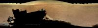
Drive on 2582, this end of drive front HazCam indicates a short climb further up-slope at Central Butte, pity most of the MastCams are compressed bayer, some grand geology on show here...
|
|
|
|
|
|
|
Nov 11 2019, 02:14 PM
Post
#409
|
|
|
Senior Member Group: Members Posts: 1074 Joined: 21-September 07 From: Québec, Canada Member No.: 3908 |
QUOTE (PaulH51 @ Nov 11 2019, 06:25 AM)  Drive on 2582, this end of drive front HazCam indicates a short climb further up-slope at Central Butte, pity most of the MastCams are compressed bayer, some grand geology on show here... I don't see Mastcam images for that sol. On the raw images page, the most recent Mastcam images are from sol 2577. |
|
|
|
|
Nov 11 2019, 08:11 PM
Post
#410
|
|
|
Senior Member Group: Members Posts: 2425 Joined: 30-January 13 From: Penang, Malaysia. Member No.: 6853 |
QUOTE (charborob @ Nov 11 2019, 10:14 PM) I don't see Mastcam images for that sol. On the raw images page, the most recent Mastcam images are from sol 2577. Those are the ones I was referring to. Except for a few of the workspace and drive direction MastCams, all recent surveys have been compressed bayer, the green cast (compression artefacts) after repair spoil the images IMHO, so I don't process or share them. |
|
|
|
|
Nov 12 2019, 12:34 AM
Post
#411
|
|
|
Member Group: Members Posts: 923 Joined: 10-November 15 Member No.: 7837 |
Compressed bayer is there to utterly frustrate any independent effort to illustrate the mission.
It is also very effective at reducing ability & effectiveness for public outreach and education. Wouldn't it be fun to hear a justification for the use of compressed bayer from someone in authority? *crickets* -------------------- |
|
|
|
|
Nov 12 2019, 01:58 AM
Post
#412
|
|
|
Founder Group: Chairman Posts: 14431 Joined: 8-February 04 Member No.: 1 |
So - just for clarity....... whilst describing those images as 'compressed bayer' is seemingly correct....they are infact an uncompressed image on the ground that has been JPGd for posting online. With the addition of TGO to the UHF relay fleet, the amount of data being returned by MSL has increased substantially in the past year meaning that a lot of MastCam imagery that might previously been returned as debayered color imagery is now returned uncompressed. When that reaches the ground....it is greyscale before processing. Given the policy of releasing 'raw' imagery....taking that uncompressed image and then JPGing it gives us the problematic data we have now. This is not privileged information - with effort, one could ascertain this via the PDS labels.
It's certainly not an intentional effort to 'frustrate any independent effort to illustrate the mission.' That, sadly, is a frustrating side effect of the raw imagery release policy and an abundance of data volume. It sucks. As to how one might get that policy changed......I think that's a problem that predates launch and is at the PI level. That said - I have, and continue, to make appeals up the chain of command for a change, even if I know change is unlikely. It's worth remembering....those terrible JPGS now.....mean in a few months you have entirely uncompressed data landing on the PDS to be enjoyed. |
|
|
|
|
Nov 12 2019, 04:28 AM
Post
#413
|
|
|
Member Group: Members Posts: 923 Joined: 10-November 15 Member No.: 7837 |
Thanks for the explanation Doug.
It's a shame to have to downgrade our expectation every time Curi drives and postpone our enthusiasm for sharing the journey until a PDS release. -------------------- |
|
|
|
|
Nov 12 2019, 02:53 PM
Post
#414
|
|
|
Founder Group: Chairman Posts: 14431 Joined: 8-February 04 Member No.: 1 |
I couldnt agree more.
|
|
|
|
|
Nov 13 2019, 01:34 PM
Post
#415
|
||
|
Senior Member Group: Members Posts: 2816 Joined: 22-April 05 From: Ridderkerk, Netherlands Member No.: 353 |
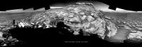
The NAVcam L view on Sol 2582.
Jan van Driel
|
|
|
|
|
|
|
Nov 13 2019, 06:38 PM
Post
#416
|
|
 Senior Member Group: Members Posts: 4246 Joined: 17-January 05 Member No.: 152 |
QUOTE (Sean @ Nov 12 2019, 01:34 AM) Compressed bayer is there to utterly frustrate any independent effort to illustrate the mission. You posted some beautifully deBayered mastcams earlier this year, Sean. You mentioned a GIMP procedure for those, but did it also involve a lot of manual work to clean up artifacts? (I'm not asking how to deBayer - we have a thread for that already.) |
|
|
|
|
Nov 14 2019, 01:04 AM
Post
#417
|
||
|
Solar System Cartographer Group: Members Posts: 10145 Joined: 5-April 05 From: Canada Member No.: 227 |
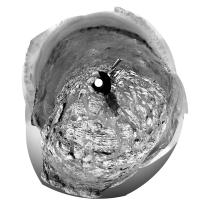
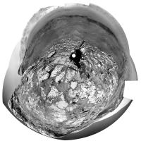
Jan's panorama for sol 2582 in circular form. Comparison with the last one shows a small move to the south (uphill).
Phil
-------------------- ... because the Solar System ain't gonna map itself.
Also to be found posting similar content on https://mastodon.social/@PhilStooke NOTE: everything created by me which I post on UMSF is considered to be in the public domain (NOT CC, public domain) |
|
|
|
|
|
|
Nov 14 2019, 07:15 PM
Post
#418
|
|
|
Member Group: Members Posts: 923 Joined: 10-November 15 Member No.: 7837 |
It's a lot of extra work to make them, not to mention the qualitative difference with subsequent JPG compression compounding the issue. I would rather spend that time creatively than prepping compromised mosiacs.
When I see bayered sequences now I am more likely to sigh and move on. QUOTE (fredk @ Nov 13 2019, 06:38 PM) You posted some beautifully deBayered mastcams earlier this year, Sean. You mentioned a GIMP procedure for those, but did it also involve a lot of manual work to clean up artifacts? (I'm not asking how to deBayer - we have a thread for that already.) -------------------- |
|
|
|
|
Nov 15 2019, 12:31 AM
Post
#419
|
||
|
Senior Member Group: Members Posts: 2425 Joined: 30-January 13 From: Penang, Malaysia. Member No.: 6853 |
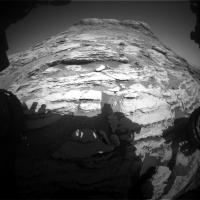
Sol 2585: dogs eye mosaic of the target Sourhope, roughly assembled in MS-ICE using the single focus images, not sure if we'll get a focus stacked version later.
|
|
|
|
|
|
|
Nov 15 2019, 03:24 AM
Post
#420
|
|
|
Senior Member Group: Members Posts: 1074 Joined: 21-September 07 From: Québec, Canada Member No.: 3908 |
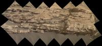
Sol 2582 Lmastcam:

|
|
|
|
|

|
Lo-Fi Version | Time is now: 16th April 2024 - 11:24 AM |
|
RULES AND GUIDELINES Please read the Forum Rules and Guidelines before posting. IMAGE COPYRIGHT |
OPINIONS AND MODERATION Opinions expressed on UnmannedSpaceflight.com are those of the individual posters and do not necessarily reflect the opinions of UnmannedSpaceflight.com or The Planetary Society. The all-volunteer UnmannedSpaceflight.com moderation team is wholly independent of The Planetary Society. The Planetary Society has no influence over decisions made by the UnmannedSpaceflight.com moderators. |
SUPPORT THE FORUM Unmannedspaceflight.com is funded by the Planetary Society. Please consider supporting our work and many other projects by donating to the Society or becoming a member. |
|