Chang'e 5 sample return mission |

  |
Chang'e 5 sample return mission |
 Dec 4 2020, 01:55 AM Dec 4 2020, 01:55 AM
Post
#211
|
||
|
Solar System Cartographer  Group: Members Posts: 10153 Joined: 5-April 05 From: Canada Member No.: 227 |
Oh well, if we can't see behind the lander, let's look under the lander.
This is one of the descent frames which was released in a reasonably good resolution. I have turned it so north is approximately at the top. I superimposed the footpad on it from the big mosaic. Then I took an image of the drill in the ground and figured out where it is in the descent image. So the drilled spot is at the left end of the visible drill tube in that image. Phil
-------------------- ... because the Solar System ain't gonna map itself.
Also to be found posting similar content on https://mastodon.social/@PhilStooke Maps for download (free PD: https://upload.wikimedia.org/wikipedia/comm...Cartography.pdf NOTE: everything created by me which I post on UMSF is considered to be in the public domain (NOT CC, public domain) |
|
 |
 
|
|
|
Dec 4 2020, 02:33 AM
Post
#212
|
|
|
Senior Member Group: Members Posts: 2082 Joined: 13-February 10 From: Ontario Member No.: 5221 |
QUOTE (djellison @ Dec 3 2020, 08:22 PM)  My guess is that the ascent stage blocked the view on the other side of the lander - and now it's gone, they might be able to do a 360 assuming everything's still healthy onboard after the impact of the ascent stage engine plume impinging on it. The sampling arm has a camera on it like Insight, so it should be possible to do a panorama, just need to stitch out the portion of the field being blocked by the end of the scoop. |
|
|
|
|
Dec 4 2020, 03:28 AM
Post
#213
|
||
|
Solar System Cartographer Group: Members Posts: 10153 Joined: 5-April 05 From: Canada Member No.: 227 |
Here's hoping! Meanwhile, looking under the lander again, as far as I can figure out at the moment this is where the other footpads should be. Does anyone have a diagram of the lander with dimensions?
Phil
-------------------- ... because the Solar System ain't gonna map itself.
Also to be found posting similar content on https://mastodon.social/@PhilStooke Maps for download (free PD: https://upload.wikimedia.org/wikipedia/comm...Cartography.pdf NOTE: everything created by me which I post on UMSF is considered to be in the public domain (NOT CC, public domain) |
|
|
|
|
|
|
Dec 4 2020, 03:57 AM
Post
#214
|
||
 Senior Member Group: Members Posts: 1421 Joined: 26-July 08 Member No.: 4270 |
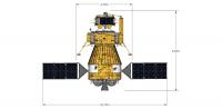
QUOTE ("Phil Stooke") Does anyone have a diagram of the lander with dimensions? I do have this, hopefully it helps:
Attached thumbnail(s)
-------------------- -- Hungry4info (Sirius_Alpha)
|
|
|
|
|
|
|
Dec 4 2020, 07:42 AM
Post
#215
|
|
|
Member Group: Members Posts: 156 Joined: 22-May 09 From: Ireland Member No.: 4792 |
Given Hungry4info's dimensional image, it should be possible to calibrate all the other parts (solar panel size, lander legs, ascender...etc.,).
John |
|
|
|
|
Dec 4 2020, 12:12 PM
Post
#216
|
||
 Member Group: Members Posts: 185 Joined: 4-January 19 Member No.: 8523 |
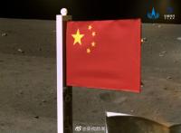
And now,...
Chang'e-5 is the first Chinese Lander to fly the Flag...
Attached thumbnail(s)
-------------------- "The Earth is a very small stage in a vast cosmic arena"
|
|
|
|
|
|
|
Dec 4 2020, 01:23 PM
Post
#217
|
|||
 Member Group: Members Posts: 809 Joined: 3-June 04 From: Brittany, France Member No.: 79 |
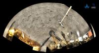
A second panorama has been made, showing the arm, the flag and trenches where samples were collected.
Link to full resolution version. I made an animation to compare 1st and 2nd panoramas. There is some difference in the projection setup.
-------------------- |
||
|
|
|
||
|
Dec 4 2020, 02:23 PM
Post
#218
|
|
 Member Group: Members Posts: 547 Joined: 1-May 06 From: Scotland (Ecosse, Escocia) Member No.: 759 |
And a fascinating big crater behind the flag....
|
|
|
|
|
Dec 4 2020, 04:27 PM
Post
#219
|
|
|
Member Group: Members Posts: 435 Joined: 14-December 15 Member No.: 7860 |
QUOTE (Huguet @ Dec 4 2020, 01:12 PM) And now,... Chang'e-5 is the first Chinese Lander to fly the Flag... Yeah, I've been waiting for this for so long!  Only now is the mission on the surface of the Moon complete and I can sleep peacefully... |
|
|
|
|
Dec 4 2020, 04:56 PM
Post
#220
|
|||
|
Member Group: Members Posts: 435 Joined: 14-December 15 Member No.: 7860 |
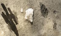
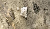
Trenches from "second panorama"
Edit: And my rough attempt to remove shadows (but there are quite a lot artificial pixels along the shadow borders)
Attached thumbnail(s)
|
||
|
|
|
||
|
Dec 4 2020, 07:32 PM
Post
#221
|
|
|
Senior Member Group: Members Posts: 2998 Joined: 30-October 04 Member No.: 105 |
QUOTE (Phil Stooke @ Nov 30 2020, 11:29 AM) Repost of an old image of the landing site. The base is LRO images and Clementine false colour. the strip without colour is missing Clementine data (a few small patches of missing data elsewhere have been patched by cloning for aesthetic effect). The blue unit is the young basalt thought to be the most likely target. Mons Rumker at centre is red-brown like the highlands suggesting it is covered with a veneer of ejecta from surrounding large craters including possibly the Iridum crater. Phil [attachment=46383:CE5_site...our_post.jpg] Mons Rumker is a volcanic construct thought to post-date the Mare basalt. Do we have a location of the Chang'e 5 landing site relative to Mons Rumker, or an accurate Lat-Long of the site? All I've found are images from the descent camera related to earlier pre-landing LROC imagery. --Bill -------------------- |
|
|
|
|
Dec 4 2020, 08:15 PM
Post
#222
|
|
|
Member Group: Members Posts: 185 Joined: 4-January 19 Member No.: 8523 |
QUOTE (Marcin600 @ Dec 4 2020, 01:27 PM) Yeah, I've been waiting for this for so long! Only now is the mission on the surface of the Moon complete and I can sleep peacefully... Its interesting to follow the importance givem to Flags in Space, the term GeoPolitics will achieve a new height, SpacePolitics... -------------------- "The Earth is a very small stage in a vast cosmic arena"
|
|
|
|
|
Dec 4 2020, 09:10 PM
Post
#223
|
|
|
Member Group: Members Posts: 540 Joined: 17-November 05 From: Oklahoma Member No.: 557 |
QUOTE (Bill Harris @ Dec 4 2020, 01:32 PM) Mons Rumker is a volcanic construct thought to post-date the Mare basalt. Do we have a location of the Chang'e 5 landing site relative to Mons Rumker, or an accurate Lat-Long of the site? --Bill Yeah, its at about 43.06 N and 51.9 W. According to Hungry4Info on a previous post (page 10) it is more accurately at 43.05680 and 51.91648 Using LROC Quickmap and my best guess as to where Rumker Mons starts, I get about 140.7 km to the WSW. You sure about Mons Rumker post dating the local Maria? I haven't heard that. Rumker seems pretty cratered, even accounting for the fact that some of those craters would be volcanic. On an aside I've noticed that where the landing legs and the scoop dug in, the soil there seems to be unusually gravelly. That's a good thing. Plenty of small rocks and pebbles to scoop up. |
|
|
|
|
Dec 4 2020, 10:12 PM
Post
#224
|
|
|
Solar System Cartographer Group: Members Posts: 10153 Joined: 5-April 05 From: Canada Member No.: 227 |
Bill - see this open access paper about the region:
https://agupubs.onlinelibrary.wiley.com/doi...9-9100.SSERVI17 Especially Figure 11 which gives ages based on crater counts. Mons Rumker is the oldest feature in the area. The basalts at the landing site are the youngest in the area and among the youngest on the Moon. See post 164 in this thread for a landing site locator, and from the first panel you should be able to find the site on other maps. Phil -------------------- ... because the Solar System ain't gonna map itself.
Also to be found posting similar content on https://mastodon.social/@PhilStooke Maps for download (free PD: https://upload.wikimedia.org/wikipedia/comm...Cartography.pdf NOTE: everything created by me which I post on UMSF is considered to be in the public domain (NOT CC, public domain) |
|
|
|
|
Dec 4 2020, 10:17 PM
Post
#225
|
||
|
Solar System Cartographer Group: Members Posts: 10153 Joined: 5-April 05 From: Canada Member No.: 227 |
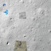
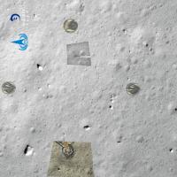
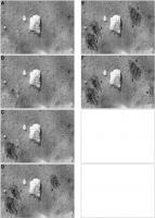
My current sampling sequence image. I don't expect anything after the last one, but there may be intermediate versions I can insert as we get more images (and of course, better quality images of the earlier sites).
Phil
-------------------- ... because the Solar System ain't gonna map itself.
Also to be found posting similar content on https://mastodon.social/@PhilStooke Maps for download (free PD: https://upload.wikimedia.org/wikipedia/comm...Cartography.pdf NOTE: everything created by me which I post on UMSF is considered to be in the public domain (NOT CC, public domain) |
|
|
|
|
|
|

|
Lo-Fi Version | Time is now: 28th April 2024 - 08:35 PM |
|
RULES AND GUIDELINES Please read the Forum Rules and Guidelines before posting. IMAGE COPYRIGHT |
OPINIONS AND MODERATION Opinions expressed on UnmannedSpaceflight.com are those of the individual posters and do not necessarily reflect the opinions of UnmannedSpaceflight.com or The Planetary Society. The all-volunteer UnmannedSpaceflight.com moderation team is wholly independent of The Planetary Society. The Planetary Society has no influence over decisions made by the UnmannedSpaceflight.com moderators. |
SUPPORT THE FORUM Unmannedspaceflight.com is funded by the Planetary Society. Please consider supporting our work and many other projects by donating to the Society or becoming a member. |
|