Atop/Around the Greenheugh Pediment, Site 79-, sol 2695-3199, 3 Mar 2020-6 Aug 2021 |

  |
Atop/Around the Greenheugh Pediment, Site 79-, sol 2695-3199, 3 Mar 2020-6 Aug 2021 |
 Jan 9 2021, 08:15 PM Jan 9 2021, 08:15 PM
Post
#421
|
|
 Member  Group: Members Posts: 809 Joined: 3-June 04 From: Brittany, France Member No.: 79 |
Wonderful work Olivier and Damia!
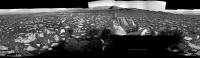
Before moving on the MastCam Left panorama, I wanted to finish a colorized version of a NavCam mosaic taken on sol 2979. Here it is: 
-------------------- |
 |
 
|
|
Jan 9 2021, 10:34 PM
Post
#422
|
||
|
Senior Member Group: Members Posts: 2819 Joined: 22-April 05 From: Ridderkerk, Netherlands Member No.: 353 |
The Navcam L panorama taken on Sol 2995.
Added 4 images taken by the R Navcam. Jan van Driel
|
|
|
|
|
|
|
Jan 10 2021, 04:43 AM
Post
#423
|
||
|
Solar System Cartographer Group: Members Posts: 10151 Joined: 5-April 05 From: Canada Member No.: 227 |
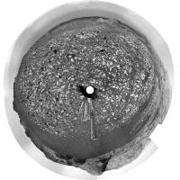
Jan's panorama in circular form. We are heading back to the planned route up the mountain.
Phil
-------------------- ... because the Solar System ain't gonna map itself.
Also to be found posting similar content on https://mastodon.social/@PhilStooke Maps for download (free PD: https://upload.wikimedia.org/wikipedia/comm...Cartography.pdf NOTE: everything created by me which I post on UMSF is considered to be in the public domain (NOT CC, public domain) |
|
|
|
|
|
|
Jan 10 2021, 08:50 AM
Post
#424
|
|
 Senior Member Group: Members Posts: 1083 Joined: 19-February 05 From: Close to Meudon Observatory in France Member No.: 172 |
[quote name='Ant103' date='Jan 9 2021, 03:54 PM' post='249184']
Nice to see you Olivier  Bravo Damia Nice to have good news from you also |
|
|
|
|
Jan 10 2021, 08:52 AM
Post
#425
|
|
|
Senior Member Group: Members Posts: 1083 Joined: 19-February 05 From: Close to Meudon Observatory in France Member No.: 172 |
QUOTE (neo56 @ Jan 9 2021, 09:15 PM)  Wonderful work Olivier and Damia! Before moving on the MastCam Left panorama, I wanted to finish a colorized version of a NavCam mosaic taken on sol 2979. Here it is: Thanks a lot Thomas : it's as if we were here
|
|
|
|
|
Jan 11 2021, 12:17 PM
Post
#426
|
|
|
Senior Member Group: Members Posts: 2920 Joined: 14-February 06 From: Very close to the Pyrénées Mountains (France) Member No.: 682 |
Thanks for the 3 french interpreters!...and the others too
 I agree Damia, this site is at least very aesthetic -------------------- |
|
|
|
|
Jan 12 2021, 08:32 AM
Post
#427
|
|
 Senior Member Group: Members Posts: 2428 Joined: 30-January 13 From: Penang, Malaysia. Member No.: 6853 |
The mission update that covered sols 2996-2998 refers to a drive back to the strategic route and onwards to the sulfate unit on sol 2998.
From the set of engineering images returned by the rover on sol 2998, it would appear the drive was either cancelled or failed to execute. I didn't find a 'fhaz00190' which is indicative of an aborted drive, so it may have been cancelled. The sol 2998 engineering images show the robotic arm is still extended with the turret horizontal, and the MAHLI camera pointing towards the rover. So I'm guessing that there may have been either an arm fault during stowage, or possibly a MAHLI lens cap issue that they want to check out before they continue. A new mission update should follow soon EDIT: The flight software detected a small but unexpected movement when un-stowing the arm, so it stopped and called home... Link |
|
|
|
|
Jan 14 2021, 04:10 AM
Post
#428
|
|
|
Senior Member Group: Members Posts: 2428 Joined: 30-January 13 From: Penang, Malaysia. Member No.: 6853 |
I'm still mourning the loss of the 'traverse map' and their insets with the 1 meter contour lines. Doesn't look like it's coming back, so I'm looking for another way of visualising the amount of elevation change after each drive.
We have xyz data in the JSON files for the images. X and Z appear to be encoded pointing data, if my assumption is correct then Y may be elevation? Does anyone know of a simple way of converting the encoded Y value into either an elevation, a change in elevation since landing? Or even a change in elevation compared to the current 'site'? The new interactive map allows users to export a GeoJSON file for the current sol, it provides the coordinates... eg sol 2995 = 137.398459, -4.734068, and a whole bunch of other useful data, but it does not report elevation. I did not post this on the maps thread to keep the signal to noise ratio of that thread at a respectful level |
|
|
|
|
Jan 15 2021, 01:52 AM
Post
#429
|
|
 Senior Member Group: Members Posts: 4246 Joined: 17-January 05 Member No.: 152 |
QUOTE (PaulH51 @ Jan 14 2021, 05:10 AM) We have xyz data in the JSON files for the images. X and Z appear to be encoded pointing data, if my assumption is correct then Y may be elevation? I guess you mean the rover_xyz field in the v2 json files? I would guess that those are the local level (LL) frame coordinates (in metres) relative to the current site origin. For the LL frame +x is north, +y is east, and +z is to nadir. So the third component should be the vertical coordinate you're looking for. |
|
|
|
|
Jan 15 2021, 03:32 AM
Post
#430
|
||
|
Senior Member Group: Members Posts: 2428 Joined: 30-January 13 From: Penang, Malaysia. Member No.: 6853 |
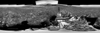
QUOTE (fredk @ Jan 15 2021, 09:52 AM) I guess you mean the rover_xyz field in the v2 json files? I would guess that those are the local level (LL) frame coordinates (in metres) relative to the current site origin. For the LL frame +x is north, +y is east, and +z is to nadir. So the third component should be the vertical coordinate you're looking for. Many thanks Fredk: Yes, it's the rover xyz field. I'll see if I can find the elevation of the LL for "site_index": 84 Here is the roughly assembled R-NavCam for sol 3000. Looks like a good drive Hope it help narrow down the location until a better stitch is posted.
EDIT: Just realised I missed a couple of top tiers 
|
|
|
|
|
|
|
Jan 15 2021, 07:26 AM
Post
#431
|
||
|
Solar System Cartographer Group: Members Posts: 10151 Joined: 5-April 05 From: Canada Member No.: 227 |
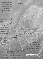
Good enough for a rough location, Paul - we are here (final map will follow in the proper place)
Phil
-------------------- ... because the Solar System ain't gonna map itself.
Also to be found posting similar content on https://mastodon.social/@PhilStooke Maps for download (free PD: https://upload.wikimedia.org/wikipedia/comm...Cartography.pdf NOTE: everything created by me which I post on UMSF is considered to be in the public domain (NOT CC, public domain) |
|
|
|
|
|
|
Jan 15 2021, 12:56 PM
Post
#432
|
||
|
Senior Member Group: Members Posts: 2819 Joined: 22-April 05 From: Ridderkerk, Netherlands Member No.: 353 |
The NAVcam R view on Sol 3000.
Jan van Driel
|
|
|
|
|
|
|
Jan 15 2021, 06:34 PM
Post
#433
|
|
|
Senior Member Group: Members Posts: 4246 Joined: 17-January 05 Member No.: 152 |
QUOTE (PaulH51 @ Jan 15 2021, 04:32 AM) I'll see if I can find the elevation of the LL for "site_index": 84 There's also the locations.xml file (currently over 15MB). That lists x,y,z coordinates and x,y appear to be relative to landing, but unfortunately z appears to be relative to the current site. That file also includes lat,long and coordinates called mapPixelH,mapPixelV, though it's not clear what map those relate to. I guess you could accumulate the z increments since landing, but that would probably also accumulate large errors. |
|
|
|
|
Jan 15 2021, 10:24 PM
Post
#434
|
||
|
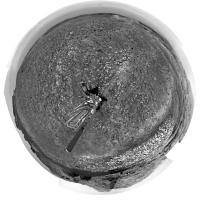
Solar System Cartographer Group: Members Posts: 10151 Joined: 5-April 05 From: Canada Member No.: 227 |
Here is Jan's panorama in circular format.
Phil
-------------------- ... because the Solar System ain't gonna map itself.
Also to be found posting similar content on https://mastodon.social/@PhilStooke Maps for download (free PD: https://upload.wikimedia.org/wikipedia/comm...Cartography.pdf NOTE: everything created by me which I post on UMSF is considered to be in the public domain (NOT CC, public domain) |
|
|
|
|
|
|
Jan 15 2021, 11:47 PM
Post
#435
|
|
|
Senior Member Group: Members Posts: 2511 Joined: 13-September 05 Member No.: 497 |
Rover position in any reference frame you want can be computed from the SPICE kernels at https://naif.jpl.nasa.gov/pub/naif/MSL/kernels/spk/
-------------------- Disclaimer: This post is based on public information only. Any opinions are my own.
|
|
|
|
|

|
Lo-Fi Version | Time is now: 25th April 2024 - 02:17 AM |
|
RULES AND GUIDELINES Please read the Forum Rules and Guidelines before posting. IMAGE COPYRIGHT |
OPINIONS AND MODERATION Opinions expressed on UnmannedSpaceflight.com are those of the individual posters and do not necessarily reflect the opinions of UnmannedSpaceflight.com or The Planetary Society. The all-volunteer UnmannedSpaceflight.com moderation team is wholly independent of The Planetary Society. The Planetary Society has no influence over decisions made by the UnmannedSpaceflight.com moderators. |
SUPPORT THE FORUM Unmannedspaceflight.com is funded by the Planetary Society. Please consider supporting our work and many other projects by donating to the Society or becoming a member. |
|