Perseverance Route Map |

  |
Perseverance Route Map |
 Mar 26 2021, 10:34 AM Mar 26 2021, 10:34 AM
Post
#46
|
|||
 Member  Group: Members Posts: 349 Joined: 20-June 07 From: Slovenia Member No.: 2461 |
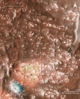
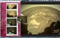
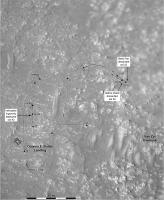
Sol 34 map update. Colored using merged RGB HiRise image.
Airfield closeup. |
||
 |
 
|
||
|
Mar 26 2021, 01:17 PM
Post
#47
|
||
|
Member Group: Members Posts: 349 Joined: 20-June 07 From: Slovenia Member No.: 2461 |
https://arkeomapia.si/3d/mars2020/index.html 3D version of the map showing the flying zone. Not perfect, but you can pan around freely. |
|
|
|
|
|
|
Mar 26 2021, 01:31 PM
Post
#48
|
|
|
Member Group: Members Posts: 240 Joined: 18-July 06 Member No.: 981 |
[quote name='Andreas Plesch' date='Mar 25 2021, 10:43 PM' post='251192']
sol 33 update: The flight zone is 30m wide in this map. So nice. Thank you! How did you place the tracks? Visual references or are they just parallel to the path? |
|
|
|
|
Mar 26 2021, 04:00 PM
Post
#49
|
|
|
Member Group: Members Posts: 248 Joined: 25-February 21 From: Waltham, Massachussetts, U.S.A. Member No.: 8974 |
QUOTE (MarkL @ Mar 26 2021, 08:31 AM)  How did you place the tracks? Visual references or are they just parallel to the path? Glad that it is useful. Making the maps helped me understand the area better. The simulated tracks are just parallel to the traverse path from the geojson data, with an offset to indicate the 2.7m width of the rover. I think the plotted track marks are 40cm wide. I could not figure out if the cited 2.7m width refers to just the body of rover, or if it includes the wheels sticking out on the sides. I am using QGIS which makes makes it possible to do all that pretty quickly and accurately. It would be nice to simulate the rotational turns but I am not sure if there is enough data available (other than the imagery) and also do not have an idea how at this point. -------------------- --
Andreas Plesch, andreasplesch at gmail dot com |
|
|
|
|
Mar 26 2021, 11:39 PM
Post
#50
|
|
|
Member Group: Members Posts: 240 Joined: 18-July 06 Member No.: 981 |
Thanks Andreas. Keep up the great work!
|
|
|
|
|
Mar 27 2021, 02:10 AM
Post
#51
|
|
|
Member Group: Members Posts: 248 Joined: 25-February 21 From: Waltham, Massachussetts, U.S.A. Member No.: 8974 |
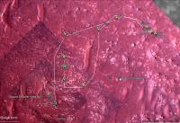
sol34 update: larger airfield to avoid crowding, simulated tracks 2.7m wide from outer edge to outer edge (I think more correct), track marks 30cm wide. Flight zone 30m wide.
 full map: 
-------------------- --
Andreas Plesch, andreasplesch at gmail dot com |
|
|
|
|
Mar 27 2021, 06:37 AM
Post
#52
|
||
|
Solar System Cartographer Group: Members Posts: 10172 Joined: 5-April 05 From: Canada Member No.: 227 |
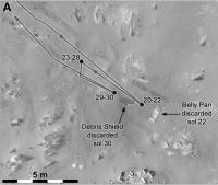
A special map for the area where the belly pan and debris shield were dropped. This is another use for the circular panoramas - they can be warped a bit to fit a HiRISE (or descent camera) image base.
Phil
-------------------- ... because the Solar System ain't gonna map itself.
Also to be found posting similar content on https://mastodon.social/@PhilStooke Maps for download (free PD: https://upload.wikimedia.org/wikipedia/comm...Cartography.pdf NOTE: everything created by me which I post on UMSF is considered to be in the public domain (NOT CC, public domain) |
|
|
|
|
|
|
Apr 3 2021, 06:21 AM
Post
#53
|
|||
|
Junior Member Group: Members Posts: 31 Joined: 10-August 12 Member No.: 6526 |
Here's the latest addition to the Google Mars project I've been working on:
Basicly, it's an image browser for Google Earth that organizes available raw images according to their geographical coordinates. The coordinates are derived from the image metadata. The raw images are generally released prior to updates to the "Where is Perseverance?" page so this gives advance knowledge of the rover position as determined by the navigation team. In any case, you can just view the images and make your own determination as I like to do. 
The following web page contains further information and downloads: http://vps78674.vps.ovh.ca/Mars2020/GoogleMars/ Mark |
||
|
|
|
||
|
Apr 4 2021, 03:05 AM
Post
#54
|
||
|
Solar System Cartographer Group: Members Posts: 10172 Joined: 5-April 05 From: Canada Member No.: 227 |
Interesting! Thanks.
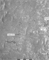
Here is a map update for sol 43. Phil
-------------------- ... because the Solar System ain't gonna map itself.
Also to be found posting similar content on https://mastodon.social/@PhilStooke Maps for download (free PD: https://upload.wikimedia.org/wikipedia/comm...Cartography.pdf NOTE: everything created by me which I post on UMSF is considered to be in the public domain (NOT CC, public domain) |
|
|
|
|
|
|
Apr 4 2021, 09:28 PM
Post
#55
|
||
|
Solar System Cartographer Group: Members Posts: 10172 Joined: 5-April 05 From: Canada Member No.: 227 |
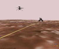
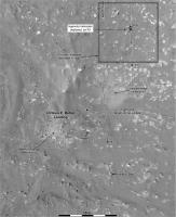
I have added recent drives and the helicopter deployment to my close-up map.
Phil
-------------------- ... because the Solar System ain't gonna map itself.
Also to be found posting similar content on https://mastodon.social/@PhilStooke Maps for download (free PD: https://upload.wikimedia.org/wikipedia/comm...Cartography.pdf NOTE: everything created by me which I post on UMSF is considered to be in the public domain (NOT CC, public domain) |
|
|
|
|
|
|
Apr 6 2021, 01:06 PM
Post
#56
|
|||
|
Junior Member Group: Members Posts: 20 Joined: 6-August 20 Member No.: 8852 |
QUOTE (markril @ Apr 3 2021, 02:21 PM) Here's the latest addition to the Google Mars project I've been working on:
Basicly, it's an image browser for Google Earth that organizes available raw images according to their geographical coordinates. The coordinates are derived from the image metadata. The raw images are generally released prior to updates to the "Where is Perseverance?" page so this gives advance knowledge of the rover position as determined by the navigation team. In any case, you can just view the images and make your own determination as I like to do.
The following web page contains further information and downloads: http://vps78674.vps.ovh.ca/Mars2020/GoogleMars/ Mark That's great, thank you! |
||
|
|
|
||
|
Apr 7 2021, 09:21 PM
Post
#57
|
||
|
Member Group: Members Posts: 349 Joined: 20-June 07 From: Slovenia Member No.: 2461 |
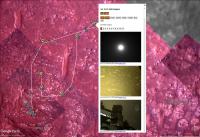
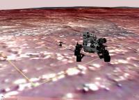
Sol 44 3D map view roughly matching today's self portrait. |
|
|
|
|
|
|
Apr 8 2021, 06:42 AM
Post
#58
|
||
|
Solar System Cartographer Group: Members Posts: 10172 Joined: 5-April 05 From: Canada Member No.: 227 |
We had a good drive on sol 47, probably about as long as the longest one to date at 35-40 m or so - I don't know the path at the start of the drive yet. We don't have a full panorama yet but the location should be fairly good.
Phil
-------------------- ... because the Solar System ain't gonna map itself.
Also to be found posting similar content on https://mastodon.social/@PhilStooke Maps for download (free PD: https://upload.wikimedia.org/wikipedia/comm...Cartography.pdf NOTE: everything created by me which I post on UMSF is considered to be in the public domain (NOT CC, public domain) |
|
|
|
|
|
|
Apr 8 2021, 07:02 AM
Post
#59
|
||
|
Junior Member Group: Members Posts: 31 Joined: 10-August 12 Member No.: 6526 |
I mentioned in my last post that the raw-image metadata can be used to plot the position of the rover prior to the official geojson track being available and here's an example for sol 47. Image locations are the blue squares:
These coordinates appear to be based on the rover's dead reckoning abilities. Once the official track comes out with the latest localization, the image locations can be refined by distributing the error along the last traverse. This is all discussed (in great detail) in this oft-mentioned document. One other interesting thing to note is that a stereo pair of Navcam images are generally downlinked 7-8 meters prior to the spot where the rover stops. Presumably this is an easy way to get an idea of what exactly is under the rover. |
|
|
|
|
|
|
Apr 8 2021, 07:32 AM
Post
#60
|
||
|
Junior Member Group: Members Posts: 20 Joined: 6-August 20 Member No.: 8852 |
QUOTE (Phil Stooke @ Apr 8 2021, 02:42 PM) We had a good drive on sol 47, probably about as long as the longest one to date at 35-40 m or so - I don't know the path at the start of the drive yet. We don't have a full panorama yet but the location should be fairly good. Phil
Perseverance has moved 38.43 meters on Sol 47. In total, it has already covered a distance of 229.74 meters. |
|
|
|
|
|
|

|
Lo-Fi Version | Time is now: 30th May 2024 - 07:32 PM |
|
RULES AND GUIDELINES Please read the Forum Rules and Guidelines before posting. IMAGE COPYRIGHT |
OPINIONS AND MODERATION Opinions expressed on UnmannedSpaceflight.com are those of the individual posters and do not necessarily reflect the opinions of UnmannedSpaceflight.com or The Planetary Society. The all-volunteer UnmannedSpaceflight.com moderation team is wholly independent of The Planetary Society. The Planetary Society has no influence over decisions made by the UnmannedSpaceflight.com moderators. |
SUPPORT THE FORUM Unmannedspaceflight.com is funded by the Planetary Society. Please consider supporting our work and many other projects by donating to the Society or becoming a member. |
|