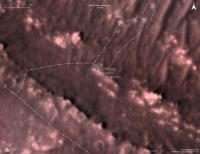
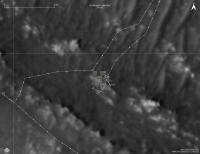
Perseverance Route Map |

  |
Perseverance Route Map |
 Dec 7 2021, 03:01 AM Dec 7 2021, 03:01 AM
Post
#211
|
|
|
Junior Member  Group: Members Posts: 91 Joined: 11-August 21 Member No.: 9072 |
Phil, I'm sorry for presenting the table in this manner: this forum has no BBcodes for displaying tables copyable as text.
The forum engine also didn't allow me to attach the *.geojson file which was used as the data source. Its download link at NASA site (mission map nicknamed 'Where is the rover') is uncopiable - but to explain in words, it is available in the hidden 'Export to JSON' under the 'hamburger' button at top left. I built this table in Excel to verify the flight lengths displayed in the official Flight Log (column "f.log") with the calculations based upon areocoordinates and the so-called "northings" / "eastings" (column "calc") which I treat as offset from equator / zero meridian in metres. Flights marked with the asterisk (*) are hops, roundtrips and other multileg 'brackets' where data is not comparable by default: the object of my investigation are straight routes where "f.log" must be equal to "calc". Flight f.log calc northing easting N E 1* 0 0,05 1093314 4354502 18.44486 77.45102 2* 4 0 1093314 4354502 18.44486 77.45102 3* 100 0,76 1093314 4354502 18.44486 77.45102 4* 266 6,1 1093313 4354501 18.44486 77.45101 5 129 130,81 1093313 4354507 18.44486 77.45112 6* 215 100,75 1093183 4354522 18.44267 77.45139 7 106 106,3 1093124 4354441 18.44166 77.44994 8 160 160,48 1093018 4354453 18.43988 77.45015 9 625 620,33 1092862 4354489 18.43724 77.45079 10* 233 97,51 1092319 4354188 18.42808 77.44545 11 383 388,24 1092319 4354091 18.42808 77.44545 12* 450 26,19 1092590 4353813 18.43266 77.43878 13* 210 12,14 1092592 4353840 18.43269 77.43924 14 2 1,53 1092603 4353834 18.43287 77.43915 15 407 410,51 1092602 4353836 18.43286 77.43917 The ratio "reported / calculated" for the straight flights shows the tendency of undervaluation (5 cases from 6); the average is 0.9943 or minus 0.57% 5 0.9861631374 7 0.9971777987 8 0.9970089731 9 1.0075282511 11 0.9865031939 15 0.9914496602 One data entry in NASA's json is corrupt: the same coordinates are shown for fligts 10 and 11. Actually while the N value seems to be close to equal, the E values must differ (see airfields F and G). Question 1: what figures for these airfields you use in your maps? Question 2: is there any hope for the total recalculation of these waypoints after helicopter shall return (approximately) to its starting point at Wright Brothers a/f when figures shall explicitly show all errors in previously calculated coordinates / flight lengths accumulated in this 'dead reckoning'? p.s. I shall be grateful if anybody posts here the direct link to the full set of four json files of waypoints/paths for Perceverance / Ingenuity. Thank you. |
 |
 
|
|
Dec 7 2021, 04:52 AM
Post
#212
|
|
|
Solar System Cartographer Group: Members Posts: 10172 Joined: 5-April 05 From: Canada Member No.: 227 |
I don't use any figures for my airfield locations. I plot them on the HiRISE base image by matching the features seen in the Navigation Camera descent images - the last few images of every flight, usually the first to be transmitted. My locations are relative to the base image, not to any coordinates. In an ideal case they would be the same.
Phil -------------------- ... because the Solar System ain't gonna map itself.
Also to be found posting similar content on https://mastodon.social/@PhilStooke Maps for download (free PD: https://upload.wikimedia.org/wikipedia/comm...Cartography.pdf NOTE: everything created by me which I post on UMSF is considered to be in the public domain (NOT CC, public domain) |
|
|
|
|
Dec 9 2021, 07:59 AM
Post
#213
|
||
|
Junior Member Group: Members Posts: 91 Joined: 11-August 21 Member No.: 9072 |
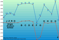
QUOTE (Phil Stooke @ Dec 7 2021, 07:52 AM)  I don't use any figures for my airfield locations. I plot them on the HiRISE base image by matching the features seen in the Navigation Camera descent images - the last few images of every flight, usually the first to be transmitted. My locations are relative to the base image, not to any coordinates. In an ideal case they would be the same. Phil Thank you, Phil. And here is the pilot version of my new chart: absolute elevations of helidromes from JZRO (Wright Brothers Field) through H with maximum flight levels' versus the start airfields. Link to the full-size 1,000×688 image is here. The file is really small (37.017 bytes). Source data credits to NASA/JPL are already written. File is uploaded to Wikipedia Commons under Creative Commons Attribution-Share Alike 4.0 International license. Adding new flights and further improvement of the chart is supposed 
Attached thumbnail(s)
|
|
|
|
|
|
|
Dec 9 2021, 07:57 PM
Post
#214
|
||
|
Solar System Cartographer Group: Members Posts: 10172 Joined: 5-April 05 From: Canada Member No.: 227 |
Map update to sol 285, with the name I misread is Gras corrected to Bras (the original source was too small to read clearly), and two names at the sol 285 location found By Paul. Thanks to all who contribute to this effort.
Phil
-------------------- ... because the Solar System ain't gonna map itself.
Also to be found posting similar content on https://mastodon.social/@PhilStooke Maps for download (free PD: https://upload.wikimedia.org/wikipedia/comm...Cartography.pdf NOTE: everything created by me which I post on UMSF is considered to be in the public domain (NOT CC, public domain) |
|
|
|
|
|
|
Dec 20 2021, 08:29 PM
Post
#215
|
||
 Member Group: Members Posts: 349 Joined: 20-June 07 From: Slovenia Member No.: 2461 |
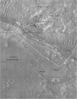
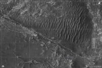
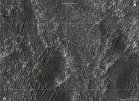
Sol 286 map update. As I haven't updated my maps in a while, the whole traverse from sol 1 is shown. |
|
|
|
|
|
|
Jan 4 2022, 07:04 PM
Post
#216
|
||
|
Member Group: Members Posts: 349 Joined: 20-June 07 From: Slovenia Member No.: 2461 |
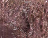
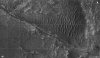
Sol 292 update, showing all sample sites to date. |
|
|
|
|
|
|
Jan 5 2022, 12:31 AM
Post
#217
|
|
|
Senior Member Group: Members Posts: 2998 Joined: 30-October 04 Member No.: 105 |
Thanks for the updates!
--Bill -------------------- |
|
|
|
|
Jan 15 2022, 08:16 PM
Post
#218
|
||
|
Member Group: Members Posts: 349 Joined: 20-June 07 From: Slovenia Member No.: 2461 |
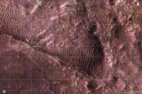
Sol 322 update. Still no movement, but plenty of activity, which gives me opportunity to post detailed map of the last two sampling areas (Brac and Issole). And thank you Phil for your input and interest. |
|
|
|
|
|
|
Jan 23 2022, 08:30 PM
Post
#219
|
||
|
Member Group: Members Posts: 349 Joined: 20-June 07 From: Slovenia Member No.: 2461 |
Short 4.3m drive marks Perserverance's first movement in a while. |
|
|
|
|
|
|
Jan 30 2022, 09:29 AM
Post
#220
|
||
|
Member Group: Members Posts: 349 Joined: 20-June 07 From: Slovenia Member No.: 2461 |
Sol 335 map update. Moving to the other side of the ridge. |
|
|
|
|
|
|
Feb 4 2022, 08:03 AM
Post
#221
|
||
|
Member Group: Members Posts: 349 Joined: 20-June 07 From: Slovenia Member No.: 2461 |
Sol 340 map update. Perseverance drove away from Issole outcrop after taking the 8th sample (?). Now moving towards Artuby ridge and a target named Rimplas (location estimated). |
|
|
|
|
|
|
Feb 7 2022, 10:47 AM
Post
#222
|
||
|
Member Group: Members Posts: 349 Joined: 20-June 07 From: Slovenia Member No.: 2461 |
Sol 342, moving fast. |
|
|
|
|
|
|
Feb 8 2022, 08:07 AM
Post
#223
|
||
|
Member Group: Members Posts: 349 Joined: 20-June 07 From: Slovenia Member No.: 2461 |
Sol 343 update. Just a short drive to the east, crossing to the south side of Artuby ridge. |
|
|
|
|
|
|
Feb 9 2022, 07:44 AM
Post
#224
|
||
|
Member Group: Members Posts: 349 Joined: 20-June 07 From: Slovenia Member No.: 2461 |
Ingenuity flight 19 map. A short 62m hop designed to escape sand pool and land at Airfield E. |
|
|
|
|
|
|
Feb 12 2022, 07:02 AM
Post
#225
|
|
|
Junior Member Group: Members Posts: 91 Joined: 11-August 21 Member No.: 9072 |
Hi, everybody! Please excuse me for the question that seems strange even to myself
 but anyway I must ask it. but anyway I must ask it.Is this screenshot a fake, or I don't know some entries in the "Where is the rover" map/JSON service at https://mars.nasa.gov/maps/location/?mission=M20 ?  The fact is, that up to this time (06:45 GMT) the map still returns the position for Perseverance's sol 343, and the last entry in Ingenuity's JSON is for sol 292 / flight 18: {"sol":292,"name":"HELI pos18","easting":4354450.039,"northing":1092802.59,"elev_geoid":-2572.994,"lon":77.45010229,"lat":18.43624068},"geometry":{"type":"Point","coordinates":[77.450102,18.436241,-2572.994]}} The scecial point of my concern is the label "Flight: 19". I tried all the settings in the left sidebar called with a 'hamburger' icon, but all the attempts to invoke this type of label (like labels "sol" and "length") failed. Another screenshot from the same source:  Note zero values for 'Distance driven' in the header line. However the location of the blue helicopter sign seems close to the actual landing spot of flight 19. Thank you, - Cherurbino. |
|
|
|
|

|
Lo-Fi Version | Time is now: 30th May 2024 - 07:34 PM |
|
RULES AND GUIDELINES Please read the Forum Rules and Guidelines before posting. IMAGE COPYRIGHT |
OPINIONS AND MODERATION Opinions expressed on UnmannedSpaceflight.com are those of the individual posters and do not necessarily reflect the opinions of UnmannedSpaceflight.com or The Planetary Society. The all-volunteer UnmannedSpaceflight.com moderation team is wholly independent of The Planetary Society. The Planetary Society has no influence over decisions made by the UnmannedSpaceflight.com moderators. |
SUPPORT THE FORUM Unmannedspaceflight.com is funded by the Planetary Society. Please consider supporting our work and many other projects by donating to the Society or becoming a member. |
|