Perseverance Route Map |

  |
Perseverance Route Map |
 Feb 12 2022, 07:59 AM Feb 12 2022, 07:59 AM
Post
#226
|
|
|
Solar System Cartographer  Group: Members Posts: 10172 Joined: 5-April 05 From: Canada Member No.: 227 |
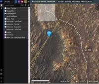
Not fake. I just reproduced it myself. Display the map and then move the cursor to the location of one of the dots representing waypoints along the route. The dark box with white text will appear to tell you which point you are pointing at (e.g. sol 130 for the point just south of your label). Move to a point between dots and you get the drive length. They have added Flight 19 as a pop-up label if you move the cursor close to that location even if the helicopter path is not displayed.
Phil -------------------- ... because the Solar System ain't gonna map itself.
Also to be found posting similar content on https://mastodon.social/@PhilStooke Maps for download (free PD: https://upload.wikimedia.org/wikipedia/comm...Cartography.pdf NOTE: everything created by me which I post on UMSF is considered to be in the public domain (NOT CC, public domain) |
 |
 
|
|
Feb 12 2022, 01:13 PM
Post
#227
|
||
|
Junior Member Group: Members Posts: 91 Joined: 11-August 21 Member No.: 9072 |
QUOTE (Phil Stooke @ Feb 12 2022, 11:59 AM)  Not fake. I just reproduced it myself. Display the map and then move the cursor to the location of one of the dots representing waypoints along the route. The dark box with white text will appear to tell you which point you are pointing at (e.g. sol 130 for the point just south of your label). Move to a point between dots and you get the drive length. They have added Flight 19 as a pop-up label if you move the cursor close to that location even if the helicopter path is not displayed. Phil I could not repeat your experiment. 1. Re: 'dots representing waypoints along the route' - there's still no (yellow) dot representing 'flight 19' on Ingenuity's route. Available are: sol 120 to the north and sol 292 at the bottom of the blue 'raindrop' icon of the helicopter which represents the landing after flight 18. 2. Re: 'e.g. sol 130' in your sample is the sol of Perseverance - I caught this position at my screenshot which includes the coordinates of the cursor location. I searched everything within the triangle 'sol 120 (I) - sol 130 (P) - sol 292 (I)', but no 'Flight' labels popped up. Could you screenshot your experiment to make the 'Flight' label visible along with the 'coordinates' string in the footer? (I shall try to find it by these figures). To make your resulting screenshot smaller it's a good idea to shrink the frame by cursor-resizing its borders and then click Alt+Printscreen to capture only the current window instead of the entire screen.
Attached thumbnail(s)
|
|
|
|
|
|
|
Feb 12 2022, 09:55 PM
Post
#228
|
|
|
Senior Member Group: Members Posts: 2517 Joined: 13-September 05 Member No.: 497 |
It's a little hard to tell what you're asking, but if you export the heli location to GeoJSON you get
CODE { "type": "FeatureCollection", "features": [ {"type":"Feature","properties":{"flight":19,"SF3_X":-447.7,"SF3_Y":-7.25,"SF3_Z":-0.51,"easting":4354486.836,"northing":1092851.995,"elev_geoid":-2569.4,"lon":77.45075678,"lat":18.43707418},"geometry":{"type":"Point","coordinates":[77.450757,18.437074,-2569.4]}} ] } which seems like the post-flight-19 location? -------------------- Disclaimer: This post is based on public information only. Any opinions are my own.
|
|
|
|
|
Feb 13 2022, 03:11 AM
Post
#229
|
|
|
Solar System Cartographer Group: Members Posts: 10172 Joined: 5-April 05 From: Canada Member No.: 227 |
I replied to Cherurbino privately but the solution to the problem may be of interest so I will mention it here. The online map behaves differently depending on the browser being used (I didn't think to check operating systems but I suppose that might also be an issue). If it doesn't do what you expect, try another browser. Cherurbino thought this whole exchange should be removed, but it might be useful to keep it as a record of the issue.
Phil -------------------- ... because the Solar System ain't gonna map itself.
Also to be found posting similar content on https://mastodon.social/@PhilStooke Maps for download (free PD: https://upload.wikimedia.org/wikipedia/comm...Cartography.pdf NOTE: everything created by me which I post on UMSF is considered to be in the public domain (NOT CC, public domain) |
|
|
|
|
Feb 14 2022, 12:19 AM
Post
#230
|
|
|
Junior Member Group: Members Posts: 91 Joined: 11-August 21 Member No.: 9072 |
QUOTE (mcaplinger @ Feb 13 2022, 12:55 AM) It's a little hard to tell what you're asking, but if you export the heli location to GeoJSON you get CODE { "type": "FeatureCollection", "features": [ {"type":"Feature","properties":{"flight":19,"SF3_X":-447.7,"SF3_Y":-7.25,"SF3_Z":-0.51,"easting":4354486.836,"northing":1092851.995,"elev_geoid":-2569.4,"lon":77.45075678,"lat":18.43707418},"geometry":{"type":"Point","coordinates":[77.450757,18.437074,-2569.4]}} ] } which seems like the post-flight-19 location? The issue was that the last line in JSON obtained by me on on February 12 (the 'Export to JSON' button) related to the Flight 18, not 19th. Also note the difference in syntax between our snippets: QUOTE (Cherurbino @ Feb 12 2022, 10:02 AM) The fact is, that up to this time (06:45 GMT) the map still returns the position for Perseverance's sol 343, and the last entry in Ingenuity's JSON is for sol 292 / flight 18: {"sol":292,"name":"HELI pos18","easting":4354450.039,"northing":1092802.59,"elev_geoid":-2572.994,"lon":77.45010229,"lat":18.43624068},"geometry":{"type":"Point","coordinates":[77.450102,18.436241,-2572.994]}} Today (February 13) all browsers return data for Flight 19 in m20_heli_waypoints.json. Thus it remains to wait for Flight 20 to repeat with browsers' experiments. ------- Phil Stooke: QUOTE (Phil Stooke @ Feb 13 2022, 06:11 AM) depending on the browser being used (I didn't think to check operating systems but I suppose that might also be an issue). Right you are, Phil. The OS may be involved indirectly, setting the minimal build version allowed for updrading the browser's engine version. Say, if one runs the old computer where max OS is Windows XP, then his browser shall not allow to upgrade its Mozilla engine with the build higher than XX.YY.ZZZZ". His browser shall continue to process the Web pages however some 'innovative' functions on them shall be ignored. Thus, the only solution for that poor user is to upgrade the whole chain: buy the modern computer, install the last OS, which opens the way to upgrade the browser and the build of its version. |
|
|
|
|
Feb 16 2022, 12:47 PM
Post
#231
|
||
 Member Group: Members Posts: 349 Joined: 20-June 07 From: Slovenia Member No.: 2461 |
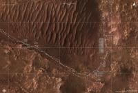
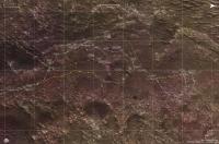
Sol 352 update, a long drive around corner of Seitah, no re-sampling at Roubion. EDIT: I replaced the map with new version, with scale bar fixed. |
|
|
|
|
|
|
Feb 16 2022, 02:10 PM
Post
#232
|
|
|
Senior Member Group: Members Posts: 1074 Joined: 21-September 07 From: Québec, Canada Member No.: 3908 |
I think the scale bar in the upper left of your map is incorrect, if I compare your map to the Perseverance Location Map (map). What is the size of the grid on your map?
|
|
|
|
|
Feb 16 2022, 02:30 PM
Post
#233
|
|
|
Member Group: Members Posts: 349 Joined: 20-June 07 From: Slovenia Member No.: 2461 |
QUOTE (charborob @ Feb 16 2022, 03:10 PM) What is the size of the grid on your map? I temporarily put the map in geographical projection instead of equirectangular to to some work and forgot to switch back, that's why the scale bar was off. I reposted the fixed version above. The grid is 100x100 meters, the same applies to Curiosity and Zhurong traverse maps. Thank you for spotting it. |
|
|
|
|
Feb 17 2022, 12:07 PM
Post
#234
|
||
|
Member Group: Members Posts: 349 Joined: 20-June 07 From: Slovenia Member No.: 2461 |
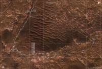
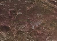
Sol 353, drive about 212.4 meters long. They added so called mid-drive locations to the rover's geojson data, which are marked as half-circles on the map. |
|
|
|
|
|
|
Feb 17 2022, 10:35 PM
Post
#235
|
||
|
Member Group: Members Posts: 349 Joined: 20-June 07 From: Slovenia Member No.: 2461 |
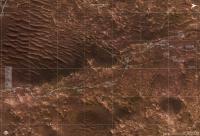
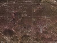
Sol 354 update. |
|
|
|
|
|
|
Feb 19 2022, 11:44 AM
Post
#236
|
||
|
Member Group: Members Posts: 349 Joined: 20-June 07 From: Slovenia Member No.: 2461 |
Sol 355, we are almost back to the landing site. |
|
|
|
|
|
|
Feb 25 2022, 03:52 PM
Post
#237
|
||
|
Member Group: Members Posts: 349 Joined: 20-June 07 From: Slovenia Member No.: 2461 |
Map update for the last couple of sols. |
|
|
|
|
|
|
Feb 28 2022, 09:45 AM
Post
#238
|
||
|
Junior Member Group: Members Posts: 91 Joined: 11-August 21 Member No.: 9072 |
Hi everybody, hi Phil!
A year ago Phil started this thread with a blank map. QUOTE (Phil Stooke @ Feb 23 2021, 01:16 AM) 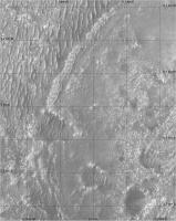 The new campaign stage shall start as soon as Perseverance shall take its last sample(s) from the Chał rock type. Another expected event shall come when at mid March the pressure shall grow as much as it allows Ingenuity to return to the normal rpm's (and 190 sec flight duration) which in its turn shall allow it to perform a non-stop flight over Seitah - now in NW direction (see news and status reports). To estimate the possibility of such a long flight an elevation map is necessary. The lower the arrival field is, longer the distance may be covered, as it already happened in Flight #9. My question / request is:
--Cherurbino
Attached thumbnail(s)
|
|
|
|
|
|
|
Feb 28 2022, 03:58 PM
Post
#239
|
|
 Senior Member Group: Members Posts: 4247 Joined: 17-January 05 Member No.: 152 |
|
|
|
|
|
Mar 1 2022, 04:11 PM
Post
#240
|
||
|
Member Group: Members Posts: 349 Joined: 20-June 07 From: Slovenia Member No.: 2461 |
Sol 362 update. |
|
|
|
|
|
|

|
Lo-Fi Version | Time is now: 30th May 2024 - 04:51 PM |
|
RULES AND GUIDELINES Please read the Forum Rules and Guidelines before posting. IMAGE COPYRIGHT |
OPINIONS AND MODERATION Opinions expressed on UnmannedSpaceflight.com are those of the individual posters and do not necessarily reflect the opinions of UnmannedSpaceflight.com or The Planetary Society. The all-volunteer UnmannedSpaceflight.com moderation team is wholly independent of The Planetary Society. The Planetary Society has no influence over decisions made by the UnmannedSpaceflight.com moderators. |
SUPPORT THE FORUM Unmannedspaceflight.com is funded by the Planetary Society. Please consider supporting our work and many other projects by donating to the Society or becoming a member. |
|