Perseverance Route Map |

  |
Perseverance Route Map |
 May 4 2022, 11:16 PM May 4 2022, 11:16 PM
Post
#271
|
|
|
Member  Group: Members Posts: 240 Joined: 18-July 06 Member No.: 981 |
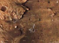
QUOTE (kymani76 @ May 3 2022, 08:56 AM)  I'm sorry but I had some earthly work that kept me away from Mars mapping, but finally found some time to update my maps. I noted that they are tinkering a lot with a geojson (like renumbering sols), which made my work a bit more complex (to track all the changes). I also reworked the distance grid as well to make it more precise (note its rectangular appearance, where latitude axis is shorter than longitude's) So here it is, update to sol 426 for Perseverance and flight 28 for Ingenuity. [attachment=50979:m2020_sol426_r001.jpg] This is a hobby for most of us I think so the time you commit to making these great images away from your other paying work is very much appreciated. |
 |
 
|
|
May 18 2022, 08:48 AM
Post
#272
|
||
 Member Group: Members Posts: 349 Joined: 20-June 07 From: Slovenia Member No.: 2461 |
QUOTE (MarkL @ May 4 2022, 11:16 PM) This is a hobby for most of us I think so the time you commit to making these great images away from your other paying work is very much appreciated. Thank you very much, positive feedback is what keeps me going.
An update to sol 439. I miss new target names, they are difficult to come by. |
|
|
|
|
|
|
May 18 2022, 05:52 PM
Post
#273
|
||
|
Solar System Cartographer Group: Members Posts: 10191 Joined: 5-April 05 From: Canada Member No.: 227 |
While busy with other things I am still collecting names - but there have been very few lately. I don't know the exact locations yet for Rocky Top (probably off this map to the north) or Devils Tanyard.
(I will post from time to time...) Phil
-------------------- ... because the Solar System ain't gonna map itself.
Also to be found posting similar content on https://mastodon.social/@PhilStooke Maps for download (free PD: https://upload.wikimedia.org/wikipedia/comm...Cartography.pdf NOTE: everything created by me which I post on UMSF is considered to be in the public domain (NOT CC, public domain) |
|
|
|
|
|
|
May 28 2022, 09:32 AM
Post
#274
|
||
|
Member Group: Members Posts: 349 Joined: 20-June 07 From: Slovenia Member No.: 2461 |
Sol 449 map update, Perserverance straddling carefully along the edge. Thanks Phil for the names update. |
|
|
|
|
|
|
May 28 2022, 09:34 AM
Post
#275
|
||
|
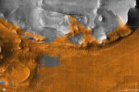
Member Group: Members Posts: 349 Joined: 20-June 07 From: Slovenia Member No.: 2461 |
Map version with severity of slopes indicated. |
|
|
|
|
|
|
May 29 2022, 08:29 PM
Post
#276
|
||
|
Member Group: Members Posts: 706 Joined: 22-April 05 Member No.: 351 |
QUOTE (kymani76 @ May 28 2022, 01:34 AM)
Map version with severity of slopes indicated. That map is a work of art. Thank you for creating it. -------------------- |
|
|
|
|
|
|
May 30 2022, 07:35 PM
Post
#277
|
|||
|
Member Group: Members Posts: 349 Joined: 20-June 07 From: Slovenia Member No.: 2461 |
QUOTE (vjkane @ May 29 2022, 08:29 PM) That map is a work of art. Thank you for creating it. Thank you, that is a really nice compliment. I also made a similar map for Curiosity, see the MSL map section. Map incorporating all the new topography names reported by Phil earlier today.
closeup of current location |
||
|
|
|
||
|
Jun 1 2022, 10:49 PM
Post
#278
|
|
|
Member Group: Members Posts: 240 Joined: 18-July 06 Member No.: 981 |
QUOTE (kymani76 @ May 30 2022, 08:35 PM) Thank you, that is a really nice compliment. I also made a similar map for Curiosity, see the MSL map section. Map incorporating all the new topography names reported by Phil earlier today. ... Beautiful maps thank you. I hesitate to offer any suggestions, but would it be possible on future versions to use a finer traverse line and smaller triangles for the waypoints? Some areas (like the current location) are congested with waypoints. Thanks again. Really enjoy poring over these! Mark |
|
|
|
|
Jun 7 2022, 08:51 AM
Post
#279
|
||
|
Member Group: Members Posts: 349 Joined: 20-June 07 From: Slovenia Member No.: 2461 |
Thank you Mark. I constantly tweak the maps in one way or another in order to improve them. I gave your suggestion a try and made lines thinner and symbols a bit smaller, but at times it is still difficult to totally de-clutter the map. I hope you like the new result. I also managed to find a few target names in Perseverance's updates. The exact sols when these targets were focused on is not indicated, but there is suggestion of existence of additional names. |
|
|
|
|
|
|
Jun 7 2022, 10:30 PM
Post
#280
|
|
|
Member Group: Members Posts: 240 Joined: 18-July 06 Member No.: 981 |
QUOTE (kymani76 @ Jun 7 2022, 09:51 AM) Thank you Mark. I constantly tweak the maps in one way or another in order to improve them. I gave your suggestion a try and made lines thinner and symbols a bit smaller, but at times it is still difficult to totally de-clutter the map. I hope you like the new result. I also managed to find a few target names in Perseverance's updates. The exact sols when these targets were focused on is not indicated, but there is suggestion of existence of additional names. Lovely. Thanks again for these wonderful immersive maps. |
|
|
|
|
Jun 13 2022, 12:36 PM
Post
#281
|
|||
|
Junior Member Group: Members Posts: 91 Joined: 11-August 21 Member No.: 9072 |
The new location map from @65dBnoise at fosstodon.org
This message was updated after flight 29 -- Cherurbino
Attached thumbnail(s)
|
||
|
|
|
||
|
Jun 20 2022, 12:57 PM
Post
#282
|
|||
|
Member Group: Members Posts: 349 Joined: 20-June 07 From: Slovenia Member No.: 2461 |
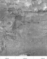
Regular update of Perseverance's location, sol 464
Map for flight 29, with terrain visible to Ingenuity highlighted in orange. |
||
|
|
|
||
|
Jun 20 2022, 06:59 PM
Post
#283
|
||
|
Solar System Cartographer Group: Members Posts: 10191 Joined: 5-April 05 From: Canada Member No.: 227 |
This is what I have so far for names. I can't guarantee all of them are in the right location (e.g. Hughes River Gap).
Phil
-------------------- ... because the Solar System ain't gonna map itself.
Also to be found posting similar content on https://mastodon.social/@PhilStooke Maps for download (free PD: https://upload.wikimedia.org/wikipedia/comm...Cartography.pdf NOTE: everything created by me which I post on UMSF is considered to be in the public domain (NOT CC, public domain) |
|
|
|
|
|
|
Jul 24 2022, 09:20 PM
Post
#284
|
||
|
Solar System Cartographer Group: Members Posts: 10191 Joined: 5-April 05 From: Canada Member No.: 227 |
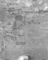
Trying to keep up with names. Paul has helped by pointing some things out to me, much appreciated. I am now pulling names out of the Analysts notebook and will post more maps soon, but there were almost no names given along the rapid traverse around the top of Seitah.
Phil
-------------------- ... because the Solar System ain't gonna map itself.
Also to be found posting similar content on https://mastodon.social/@PhilStooke Maps for download (free PD: https://upload.wikimedia.org/wikipedia/comm...Cartography.pdf NOTE: everything created by me which I post on UMSF is considered to be in the public domain (NOT CC, public domain) |
|
|
|
|
|
|
Jul 25 2022, 12:16 AM
Post
#285
|
|||
|
Solar System Cartographer Group: Members Posts: 10191 Joined: 5-April 05 From: Canada Member No.: 227 |
Two more maps with names in this area.
Phil
-------------------- ... because the Solar System ain't gonna map itself.
Also to be found posting similar content on https://mastodon.social/@PhilStooke Maps for download (free PD: https://upload.wikimedia.org/wikipedia/comm...Cartography.pdf NOTE: everything created by me which I post on UMSF is considered to be in the public domain (NOT CC, public domain) |
||
|
|
|
||
|

|
Lo-Fi Version | Time is now: 9th June 2024 - 06:35 AM |
|
RULES AND GUIDELINES Please read the Forum Rules and Guidelines before posting. IMAGE COPYRIGHT |
OPINIONS AND MODERATION Opinions expressed on UnmannedSpaceflight.com are those of the individual posters and do not necessarily reflect the opinions of UnmannedSpaceflight.com or The Planetary Society. The all-volunteer UnmannedSpaceflight.com moderation team is wholly independent of The Planetary Society. The Planetary Society has no influence over decisions made by the UnmannedSpaceflight.com moderators. |
SUPPORT THE FORUM Unmannedspaceflight.com is funded by the Planetary Society. Please consider supporting our work and many other projects by donating to the Society or becoming a member. |
|