Perseverance Route Map |

  |
Perseverance Route Map |
 Jul 26 2022, 06:59 PM Jul 26 2022, 06:59 PM
Post
#286
|
||
|
Solar System Cartographer  Group: Members Posts: 10173 Joined: 5-April 05 From: Canada Member No.: 227 |
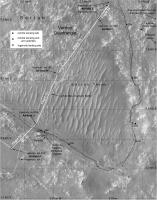
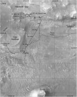
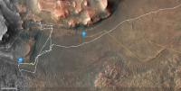
This map goes back earlier with a few names from the drive north after the Seitah sampling.
A particularly significant point is the location labelled '350', the end of drive location on sol 350. That drive was not documented with the usual end of drive panorama and the location shows up as 351 on the mission map. The real 351 location is further along the path, and the map misleadingly suggests the '350' point is a waypoint along that drive. The text of the Analyst's notebook makes it clear there was a sol 350 drive and the raw Navcam images for sol 350 show stages along that drive. The rear Hazcams for the start of sol 351 show the same location before the 351 drive. So this 'stealth drive' has not been shown correctly on any map up to now. Phil
-------------------- ... because the Solar System ain't gonna map itself.
Also to be found posting similar content on https://mastodon.social/@PhilStooke Maps for download (free PD: https://upload.wikimedia.org/wikipedia/comm...Cartography.pdf NOTE: everything created by me which I post on UMSF is considered to be in the public domain (NOT CC, public domain) |
|
 |
 
|
|
|
Jul 26 2022, 09:19 PM
Post
#287
|
|
|
Founder Group: Chairman Posts: 14432 Joined: 8-February 04 Member No.: 1 |
QUOTE (Phil Stooke @ Jul 26 2022, 10:59 AM)  A particularly significant point is the location labelled '350', the end of drive location on sol 350. That drive was not documented with the usual end of drive panorama and the location shows up as 351 on the mission map. I'm guessing that was a multi sol drive without ground in the loop. |
|
|
|
|
Jul 27 2022, 04:49 PM
Post
#288
|
|
|
Solar System Cartographer Group: Members Posts: 10173 Joined: 5-April 05 From: Canada Member No.: 227 |
Yes, it was.
-------------------- ... because the Solar System ain't gonna map itself.
Also to be found posting similar content on https://mastodon.social/@PhilStooke Maps for download (free PD: https://upload.wikimedia.org/wikipedia/comm...Cartography.pdf NOTE: everything created by me which I post on UMSF is considered to be in the public domain (NOT CC, public domain) |
|
|
|
|
Jul 29 2022, 09:25 PM
Post
#289
|
||
|
Solar System Cartographer Group: Members Posts: 10173 Joined: 5-April 05 From: Canada Member No.: 227 |
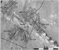
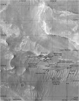
Putting together some details from earlier in the mission. Here is a map of the Issole region showing the rover positions at the various stops arounmd the outcrop.
Phil
-------------------- ... because the Solar System ain't gonna map itself.
Also to be found posting similar content on https://mastodon.social/@PhilStooke Maps for download (free PD: https://upload.wikimedia.org/wikipedia/comm...Cartography.pdf NOTE: everything created by me which I post on UMSF is considered to be in the public domain (NOT CC, public domain) |
|
|
|
|
|
|
Aug 27 2022, 01:55 AM
Post
#290
|
||
 Member Group: Members Posts: 714 Joined: 3-January 08 Member No.: 3995 |
Moving back south:
|
|
|
|
|
|
|
Aug 31 2022, 07:16 AM
Post
#291
|
||
|
Solar System Cartographer Group: Members Posts: 10173 Joined: 5-April 05 From: Canada Member No.: 227 |
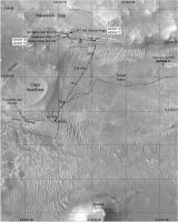
Quick update to sol 543. I'm making maps to record names, and will post them from time to time. No, I don't really have time for this!
Next, the previous map of this area with names... Phil
-------------------- ... because the Solar System ain't gonna map itself.
Also to be found posting similar content on https://mastodon.social/@PhilStooke Maps for download (free PD: https://upload.wikimedia.org/wikipedia/comm...Cartography.pdf NOTE: everything created by me which I post on UMSF is considered to be in the public domain (NOT CC, public domain) |
|
|
|
|
|
|
Sep 8 2022, 02:23 AM
Post
#292
|
||||
|
Solar System Cartographer Group: Members Posts: 10173 Joined: 5-April 05 From: Canada Member No.: 227 |
Some recent maps I am using to document names and helicopter flights.
Phil
-------------------- ... because the Solar System ain't gonna map itself.
Also to be found posting similar content on https://mastodon.social/@PhilStooke Maps for download (free PD: https://upload.wikimedia.org/wikipedia/comm...Cartography.pdf NOTE: everything created by me which I post on UMSF is considered to be in the public domain (NOT CC, public domain) |
|||
|
|
|
|||
|
Sep 8 2022, 01:51 PM
Post
#293
|
|
 Member Group: Members Posts: 701 Joined: 3-December 04 From: Boulder, Colorado, USA Member No.: 117 |
Hi Phil-
Looks like a typo on the latest (and wonderful as always) Perseverance map- the "541-542" label is used in two locations. John |
|
|
|
|
Sep 8 2022, 03:41 PM
Post
#294
|
|
|
Solar System Cartographer Group: Members Posts: 10173 Joined: 5-April 05 From: Canada Member No.: 227 |
Oops - yes, should be 541 and 542 at the two points. I don't know where that came from. Will fix shortly.
Phil -------------------- ... because the Solar System ain't gonna map itself.
Also to be found posting similar content on https://mastodon.social/@PhilStooke Maps for download (free PD: https://upload.wikimedia.org/wikipedia/comm...Cartography.pdf NOTE: everything created by me which I post on UMSF is considered to be in the public domain (NOT CC, public domain) |
|
|
|
|
Sep 9 2022, 07:10 AM
Post
#295
|
||
|
Solar System Cartographer Group: Members Posts: 10173 Joined: 5-April 05 From: Canada Member No.: 227 |
This is the corrected map. Good job I have an army of proof-readers out there! Corrections are always welcome.
Phil
-------------------- ... because the Solar System ain't gonna map itself.
Also to be found posting similar content on https://mastodon.social/@PhilStooke Maps for download (free PD: https://upload.wikimedia.org/wikipedia/comm...Cartography.pdf NOTE: everything created by me which I post on UMSF is considered to be in the public domain (NOT CC, public domain) |
|
|
|
|
|
|
Sep 12 2022, 11:02 PM
Post
#296
|
|||
 Senior Member Group: Members Posts: 2429 Joined: 30-January 13 From: Penang, Malaysia. Member No.: 6853 |
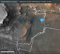
Screen captures of the interactive map: Shows the rover's position after the long drive during sol 555 (219.9 m / 721.47 ft) including an interesting diversion before crossing another TAR, it also shows the location of 'Enchanted Lake' about 20 meters northeast of the rover's sol 555 location. Also shown the helicopters position after flight 31 on sol 550 (97.7 m / 321 ft)
The calculated distance between the two craft is currently 857.7 m / 2814 ft. Communications between the craft remains good with 187 (flight 31) images received from the helicopter after the drive.
|
||
|
|
|
||
|
Sep 18 2022, 10:20 AM
Post
#297
|
||
 Member Group: Members Posts: 677 Joined: 9-May 21 From: Germany Member No.: 9017 |
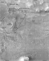
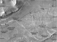
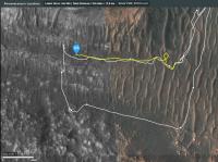
Here is a map of the eastern part of future potential traverse paths (white lines) for Perseverance.
Thick contour lines every 10 meters, thin lines every meter. Numbers are sols on the past traverse. The future potential paths are digitized from the map shown at the NASA press conference on 2022-09-15 .
|
|
|
|
|
|
|
Sep 19 2022, 03:08 AM
Post
#298
|
|
|
Senior Member Group: Members Posts: 2998 Joined: 30-October 04 Member No.: 105 |
"Screen captures of the interactive map: Shows the rover's position after the long drive during sol 555 (219.9 m / 721.47 ft) including..." (Paul)
Thanks Paul. Ingenuity has to be the Epic engineering story on Mars. I am astounded that she keeps going since she is a much lighter and simpler mechanism than the Rovers. I would have expected the batteries to have expired by now. --Bill -------------------- |
|
|
|
|
Sep 19 2022, 03:14 AM
Post
#299
|
|
|
Senior Member Group: Members Posts: 2998 Joined: 30-October 04 Member No.: 105 |
"Here is a map of the eastern part of future potential traverse paths (white lines) for Perseverance..." (Tau)
That is a tremendous map format, and especially that it shows potential future paths. --Bill -------------------- |
|
|
|
|
Sep 19 2022, 09:24 PM
Post
#300
|
||
|
Solar System Cartographer Group: Members Posts: 10173 Joined: 5-April 05 From: Canada Member No.: 227 |
Yes, it's a very nice map.
Here is a quick update to the present time showing the latest helicopter flight on sol 561 and a few names which Paul has been helping me track down. Phil
-------------------- ... because the Solar System ain't gonna map itself.
Also to be found posting similar content on https://mastodon.social/@PhilStooke Maps for download (free PD: https://upload.wikimedia.org/wikipedia/comm...Cartography.pdf NOTE: everything created by me which I post on UMSF is considered to be in the public domain (NOT CC, public domain) |
|
|
|
|
|
|

|
Lo-Fi Version | Time is now: 30th May 2024 - 11:44 PM |
|
RULES AND GUIDELINES Please read the Forum Rules and Guidelines before posting. IMAGE COPYRIGHT |
OPINIONS AND MODERATION Opinions expressed on UnmannedSpaceflight.com are those of the individual posters and do not necessarily reflect the opinions of UnmannedSpaceflight.com or The Planetary Society. The all-volunteer UnmannedSpaceflight.com moderation team is wholly independent of The Planetary Society. The Planetary Society has no influence over decisions made by the UnmannedSpaceflight.com moderators. |
SUPPORT THE FORUM Unmannedspaceflight.com is funded by the Planetary Society. Please consider supporting our work and many other projects by donating to the Society or becoming a member. |
|