Anatolia |

  |
Anatolia |
 Nov 21 2005, 04:11 PM Nov 21 2005, 04:11 PM
Post
#16
|
|
|
Member  Group: Members Posts: 320 Joined: 19-June 04 Member No.: 85 |
Great work, Phil! It'll look awesome once you get everything stiched together, not to mention how informative it will be.
-------------------- |
 |
 
|
|
Nov 21 2005, 05:25 PM
Post
#17
|
|
 Member Group: Members Posts: 524 Joined: 24-November 04 From: Heraklion, GR. Member No.: 112 |
Great views of Anatolia, thanks Phil !
These projections enhance the feeling of being there, and observing the martian scenery from up close. Which invites this (out of subject thread) question : Since images and distances of features from the rovers' current location are (or will be) known, how difficult is it to construct a VR world that includes Meridiani and Gusev ? Some aerial views of Columbia Hils published by JPL a short while ago approximate what I have in mind, but a VR world would be way better  (although the scientific merit might admittedly be questionable) (although the scientific merit might admittedly be questionable)How cool would it be to float 2m above Endurance, looking at Burns Cliff and the sand dunes ! 
|
|
|
|
|
Nov 21 2005, 07:40 PM
Post
#18
|
|
|
Solar System Cartographer Group: Members Posts: 10166 Joined: 5-April 05 From: Canada Member No.: 227 |
well, we've got the pics, and a reasonable terrain model could be put togther from them - Ron Li has already done some of this - so somebody with lots of time and suitable software could certainly do it.
Phil -------------------- ... because the Solar System ain't gonna map itself.
Also to be found posting similar content on https://mastodon.social/@PhilStooke Maps for download (free PD: https://upload.wikimedia.org/wikipedia/comm...Cartography.pdf NOTE: everything created by me which I post on UMSF is considered to be in the public domain (NOT CC, public domain) |
|
|
|
|
Nov 22 2005, 02:08 AM
Post
#19
|
||
|
Solar System Cartographer Group: Members Posts: 10166 Joined: 5-April 05 From: Canada Member No.: 227 |
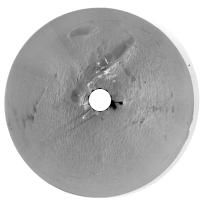
Nico asked for a larger sol 72 pan. I hope this is the one (of two on that day) which was intended.
Phil
-------------------- ... because the Solar System ain't gonna map itself.
Also to be found posting similar content on https://mastodon.social/@PhilStooke Maps for download (free PD: https://upload.wikimedia.org/wikipedia/comm...Cartography.pdf NOTE: everything created by me which I post on UMSF is considered to be in the public domain (NOT CC, public domain) |
|
|
|
|
|
|
Nov 22 2005, 03:02 AM
Post
#20
|
|
|
Member Group: Members Posts: 166 Joined: 20-September 05 From: North Texas Member No.: 503 |
QUOTE (Phil Stooke @ Nov 22 2005, 02:08 AM) Nico asked for a larger sol 72 pan. I hope this is the one (of two on that day) which was intended. Phil  I was wondering what causes the pairs of "objects" that appear on a radial extending at about an angle of 70 degrees from the center to the horizon. I suspect it is some kind of spurious projection generated in the image processing. But I would like to hear exactly what causes it (before some other forum identifies this as the latest example of proof of civilization on the 4th rock from the sun). 
|
|
|
|
|
Nov 22 2005, 09:17 AM
Post
#21
|
|
|
Senior Member Group: Members Posts: 2998 Joined: 30-October 04 Member No.: 105 |
Those areas are along a stitch line and appear to be a transmission loss in one of the frames that was Autostitched.
--Bill -------------------- |
|
|
|
|
Nov 22 2005, 01:59 PM
Post
#22
|
||
|
Senior Member Group: Members Posts: 1636 Joined: 9-May 05 From: Lima, Peru Member No.: 385 |
QUOTE (Phil Stooke @ Nov 21 2005, 09:08 PM) Nico asked for a larger sol 72 pan. I hope this is the one (of two on that day) which was intended. Phil
After comparing the ripples around Antolia and Erebus, there is a big difference. I have the impression that the way between Eagle and Endurace, looks like a calm sea and around Erebus looks like that there were more current of water if that zone was a lake. The more current is the water (due to greater slope pending) around Erebus than around Endurance, the surface has bigger waves of ripples around the Erebus. Rodolfo |
|
|
|
|
|
|
Nov 22 2005, 04:41 PM
Post
#23
|
|
|
Member Group: Members Posts: 524 Joined: 24-November 04 From: Heraklion, GR. Member No.: 112 |
I think the ripples are eolian features, so water depth is of no significance regarding their size.
|
|
|
|
|
Nov 22 2005, 05:21 PM
Post
#24
|
|
|
Solar System Cartographer Group: Members Posts: 10166 Joined: 5-April 05 From: Canada Member No.: 227 |
The dark spots mentioned by DFinfrock are from the original panorama mosaic at the PDS site. I very rarely find time to make my own pans. If you look closely you will see several others closer to the centre but getting smaller near the centre. The spots are actually labels showing elevation angles on the mosaic. I could have edited them out but didn't.
PS slight delay on the Anatolia map. I got sidetracked by a new map of Eagle crater which I will release soon. Phil -------------------- ... because the Solar System ain't gonna map itself.
Also to be found posting similar content on https://mastodon.social/@PhilStooke Maps for download (free PD: https://upload.wikimedia.org/wikipedia/comm...Cartography.pdf NOTE: everything created by me which I post on UMSF is considered to be in the public domain (NOT CC, public domain) |
|
|
|
|
Nov 22 2005, 05:22 PM
Post
#25
|
|
 Chief Assistant Group: Admin Posts: 1409 Joined: 5-January 05 From: Ierapetra, Greece Member No.: 136 |
Thank you for the big one Phil
Nico -------------------- photographer, space imagery enthusiast, proud father and partner, and geek.
http://500px.com/sacred-photons & |
|
|
|
|
Nov 22 2005, 06:28 PM
Post
#26
|
|
|
Senior Member Group: Members Posts: 2998 Joined: 30-October 04 Member No.: 105 |
QUOTE The spots are actually labels showing elevation angles on the mosaic. Well, duh. So they are. We are seeing "anatolia-like" features on the Olympia-Mogollon boundary at Erebus. The "sand" (ripple material) is evidently moving into fractures or voids in the bedrock which which may be the cause of these anatolia features and of the small craters we've been seeing. I think of the term "sapping" when I think of this sand withdrawl, but that is a loaded term since it implies groundwater so we should use another descriptive term. I can visualize this "sand withdrawl" process easily enough, it occurs in the Karst topography that I'm familiar with. The problem I have is "where does the sand go?" once it goes into the void or fracture. Once a fracture fills up, no more sand can enter and that is all it will ever do. There must be a process that removes the sand, like flowing water in a cavern, or very deep fractures or active fractures that are young and keep opening. All of which, IMO, are not likely to to be happening here. Any ideas of a process that could be involved here (besides "pugilistic microbes" eating the sand... )? --Bill -------------------- |
|
|
|
|
Nov 22 2005, 07:05 PM
Post
#27
|
|
|
Senior Member Group: Members Posts: 1636 Joined: 9-May 05 From: Lima, Peru Member No.: 385 |
That topic is interesting. If these holes have stopped of sapping process, then after hundreds, thousands or millions years, depending to the eolian force, these holes whould be totally concealed.
Then these sapping must be somewhat related with something under sub-surface is changing its state. Maybe it is due to a sublimation process of remant water under the sub-sufarce. Also, maybe, another kind of material, amoniaca, the decomposition of something that might reduce its size and that process may lead to sink the upper portion of sand. Rodolfo |
|
|
|
|
Nov 22 2005, 07:36 PM
Post
#28
|
|
|
Senior Member Group: Members Posts: 1636 Joined: 9-May 05 From: Lima, Peru Member No.: 385 |
QUOTE (TheChemist @ Nov 22 2005, 11:41 AM) I think the ripples are eolian features, so water depth is of no significance regarding their size. That zone, from Eagle to Erebus crater is relatively plane with slight positive from North to South. The wind force must be about the same for all that zone except to around Erebus rim where there might be somewhat more due to higher surface. On the other hand, I have observed that the zone with stronger wind, the surface has bigger ripples than other zone with tenue winds. The conclusion, the beginning, the water have played the formation of waves of the surface and later by the eolian factor. Rodolfo |
|
|
|
|
Nov 22 2005, 10:19 PM
Post
#29
|
|
|
Member Group: Members Posts: 866 Joined: 15-March 05 From: Santa Cruz, CA Member No.: 196 |
If the subsurface is a large portion of brine ice, it shoudl continue to outgas and shrink, especially during Mars' processional cycles which would be the basis of greatest change. Such outgassing and surface contraction and cracking followed by filling could go on far into the future, or whenever Mars' runs out of gas...
are we still inside that window? i dont know but i think this window of time might be far longer than we expect of an otherwise geologically comatose planet. |
|
|
|
|
Nov 23 2005, 06:13 AM
Post
#30
|
|
 Senior Member Group: Members Posts: 2228 Joined: 1-December 04 From: Marble Falls, Texas, USA Member No.: 116 |
It seems logical to me to suspect that the processes forming the the large features at Anatolia are the same or similar to those causing the smaller features we're seeing at Erebus (and that we've also seen at Endurance and elsewhere). Some kind of subsurface sapping or subsidence activity is the only way that I can think of to form them. But I run into the same problem Bill described. Once the crack fills up, how do you continue to maintain a surface expression as drifting sand/dust continually moves in to fill the low spots?
I'm guessing that the fractures at Erebus are probably billions of years old, while those around Eagle and Endurance are much more recent. But maybe something unrelated to the impacts has created fractures. Regardless, I have to suspect something more recent is creating these features in the drifts. If it is sublimating subsurface ice creating the voids, it would be amazing after all these years. I was imagining all the shallow ice this near to the equator would be gone by now. These features really are other-worldly. I have not been able to come up with a set of processes to form them that is satisfactory to me. Could periodic temperature changes cause expansion and contraction that compresses the sediment to create new space? Maybe the processes of sediment compaction at Meridiani are slower than one would expect on earth... -------------------- ...Tom
I'm not a Space Fan, I'm a Space Exploration Enthusiast. |
|
|
|
|

|
Lo-Fi Version | Time is now: 23rd May 2024 - 01:40 PM |
|
RULES AND GUIDELINES Please read the Forum Rules and Guidelines before posting. IMAGE COPYRIGHT |
OPINIONS AND MODERATION Opinions expressed on UnmannedSpaceflight.com are those of the individual posters and do not necessarily reflect the opinions of UnmannedSpaceflight.com or The Planetary Society. The all-volunteer UnmannedSpaceflight.com moderation team is wholly independent of The Planetary Society. The Planetary Society has no influence over decisions made by the UnmannedSpaceflight.com moderators. |
SUPPORT THE FORUM Unmannedspaceflight.com is funded by the Planetary Society. Please consider supporting our work and many other projects by donating to the Society or becoming a member. |
|