Eagle Crater Map, documenting the early mission |

  |
Eagle Crater Map, documenting the early mission |
 Nov 26 2005, 04:17 AM Nov 26 2005, 04:17 AM
Post
#1
|
||
|
Solar System Cartographer  Group: Members Posts: 10168 Joined: 5-April 05 From: Canada Member No.: 227 |
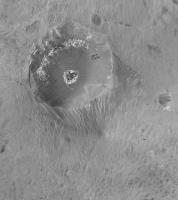
This is what delayed my Anatolia map. It shows what is possible with these panoramas, I note that this is easier in very low relief areas...
This is not perfect, and in particular the crater's outer slope was not imaged completely and is distorted here. There are other distortions too, including a sort of fish-eye effect which makes Eagle bigger than it should be and distant areas smaller. The hard part is just making the image in the first place, but once you have it, it can always be rubber-sheeted to fit better positional control. Eventually, this map (or an improved version) and similar maps of other areas where quite a lot happened, will form the basis for an atlas-style presentation of the whole mission. Phil
-------------------- ... because the Solar System ain't gonna map itself.
Also to be found posting similar content on https://mastodon.social/@PhilStooke Maps for download (free PD: https://upload.wikimedia.org/wikipedia/comm...Cartography.pdf NOTE: everything created by me which I post on UMSF is considered to be in the public domain (NOT CC, public domain) |
|
 |
 
|
|
|
Nov 26 2005, 04:51 AM
Post
#2
|
|
 Senior Member Group: Moderator Posts: 2262 Joined: 9-February 04 From: Melbourne - Oz Member No.: 16 |
Now that is nice!
 Great work Phil. -------------------- |
|
|
|
|
Nov 26 2005, 05:10 AM
Post
#3
|
|
|
Member Group: Admin Posts: 468 Joined: 11-February 04 From: USA Member No.: 21 |
This is a great looking map Phil. I've been pondering of this sort of thing since the misisons began, and you've nailed it. I'm trying something similar in the Paso Robles area for Spirit. Are you projecting onto a terrain model, using images from several different viewpoints? If so, do you overlap the images, or is there some sort of blending to control which image shows through at any given point?
Since Eagle Crater, and all the other interesting terrain features for that matter, are themselves irregularly shaped objects, I guess I shouldn't be too surprised how well you've done with this problem. Very nice job! |
|
|
|
|
Nov 26 2005, 05:16 AM
Post
#4
|
|
|
Solar System Cartographer Group: Members Posts: 10168 Joined: 5-April 05 From: Canada Member No.: 227 |
I'm not using a real terrain model. This is not well controlled. But I am trying to be careful to make sections of the mosaic match each other properly. This could be rectified using a good terrain model, later on if they become available. At the moment my map is more art than science. But all cartography is a mix of the two.
I'd be very interested to see any other things people do like this. Phil -------------------- ... because the Solar System ain't gonna map itself.
Also to be found posting similar content on https://mastodon.social/@PhilStooke Maps for download (free PD: https://upload.wikimedia.org/wikipedia/comm...Cartography.pdf NOTE: everything created by me which I post on UMSF is considered to be in the public domain (NOT CC, public domain) |
|
|
|
|
Nov 26 2005, 08:51 AM
Post
#5
|
|
|
Senior Member Group: Members Posts: 2998 Joined: 30-October 04 Member No.: 105 |
Very good, Phil. I'll be looking forward to future releases of this type of mapping.
--Bill -------------------- |
|
|
|
|
Nov 26 2005, 09:03 AM
Post
#6
|
|
|
Member Group: Members Posts: 877 Joined: 7-March 05 From: Switzerland Member No.: 186 |
That's great Phil!
I'm especially fascinated about the visible track of the airbag. It's clearly visible where it runs Now to me, it seems it was a "hole hanger" 
-------------------- |
|
|
|
|
Nov 26 2005, 10:57 AM
Post
#7
|
|
 Member Group: Members Posts: 221 Joined: 25-March 05 Member No.: 217 |
Hi Phil
Great map quite a hole hanger indeed, in fact to me it looks like the lander in it's airbags leaned back a little before rolling into Eagle crater! Roy F aka Reckless |
|
|
|
|
Nov 26 2005, 10:59 AM
Post
#8
|
|
|
Senior Member Group: Members Posts: 1870 Joined: 20-February 05 Member No.: 174 |
You can also see "bounce" rock where it was hit by airbags SE of the crater.
|
|
|
|
|
Nov 26 2005, 11:34 AM
Post
#9
|
|
|
Member Group: Members Posts: 713 Joined: 30-March 05 Member No.: 223 |
WOW, that's awsome, Phil !
unbelievable what your're able to make out of those panoramas
|
|
|
|
|
Nov 26 2005, 11:54 AM
Post
#10
|
|
 Senior Member Group: Members Posts: 2492 Joined: 15-January 05 From: center Italy Member No.: 150 |
Congratulations, Phil!
If you need an helping hand for the atlas presentations, I'm here!  BTW, can someone indicate an existing 3D/elevation map of Eagle crater? this would allow to correct all distorsions Phil is talking about! (otherwise, we need a volunteer armed wit patience and Parallax calculator...  ) )
-------------------- I always think before posting! - Marco -
|
|
|
|
|
Nov 26 2005, 04:09 PM
Post
#11
|
|
 Interplanetary Dumpster Diver Group: Admin Posts: 4404 Joined: 17-February 04 From: Powell, TN Member No.: 33 |
QUOTE (dilo @ Nov 26 2005, 11:54 AM) Congratulations, Phil! If you need an helping hand for the atlas presentations, I'm here! BTW, can someone indicate an existing 3D/elevation map of Eagle crater? this would allow to correct all distorsions Phil is talking about! (otherwise, we need a volunteer armed wit patience and Parallax calculator... ) That is an amazing projection! -------------------- |
|
|
|
|
Nov 26 2005, 07:07 PM
Post
#12
|
|
 Senior Member Group: Members Posts: 2228 Joined: 1-December 04 From: Marble Falls, Texas, USA Member No.: 116 |
Bravo, Phil. Most of the things we try to do with the raw images will have some inherent errors, but that does not prevent the work products from being useful. That's a keeper, and I am saving a copy for future reference.
Thanks. -------------------- ...Tom
I'm not a Space Fan, I'm a Space Exploration Enthusiast. |
|
|
|
|
Nov 26 2005, 08:25 PM
Post
#13
|
|
|
Senior Member Group: Members Posts: 1636 Joined: 9-May 05 From: Lima, Peru Member No.: 385 |
Very good Phil. You has become an polar mapping expert. The picture is very nostalgic since it is the birthplace of Oppy. A very important picture.
Rodolfo |
|
|
|
|
Nov 28 2005, 08:47 PM
Post
#14
|
|
|
Member Group: Members Posts: 295 Joined: 2-March 04 From: Central California Member No.: 45 |
Great work Phil.
With this kind of view it's easy to imagine that if Oppy had rolled the other way and not into the crater, they might not have taken it down into the crater. It would have taken longer to get the 'blueberry' images. I imagine they would have spent a lot more time at Fram before heading to Endurance. I don't think they would have spent much time at Eagle though. On to Victoria! Eric P / MizarKey -------------------- Eric P / MizarKey
|
|
|
|
|

|
Lo-Fi Version | Time is now: 26th May 2024 - 01:24 PM |
|
RULES AND GUIDELINES Please read the Forum Rules and Guidelines before posting. IMAGE COPYRIGHT |
OPINIONS AND MODERATION Opinions expressed on UnmannedSpaceflight.com are those of the individual posters and do not necessarily reflect the opinions of UnmannedSpaceflight.com or The Planetary Society. The all-volunteer UnmannedSpaceflight.com moderation team is wholly independent of The Planetary Society. The Planetary Society has no influence over decisions made by the UnmannedSpaceflight.com moderators. |
SUPPORT THE FORUM Unmannedspaceflight.com is funded by the Planetary Society. Please consider supporting our work and many other projects by donating to the Society or becoming a member. |
|