Opportunity Leaves Olympia, Goodbye Purgatory 2 |

  |
Opportunity Leaves Olympia, Goodbye Purgatory 2 |
 Feb 25 2006, 07:46 AM Feb 25 2006, 07:46 AM
Post
#46
|
||
 Member  Group: Members Posts: 362 Joined: 12-June 05 From: Kiama, Australia Member No.: 409 |
Thats another Wow!!
Attached thumbnail(s)
|
|
 |
 
|
|
|
Feb 25 2006, 09:00 AM
Post
#47
|
||
 Senior Member Group: Members Posts: 2492 Joined: 15-January 05 From: center Italy Member No.: 150 |
Full 360 deg panorma from right cam (70% scale)
Attached thumbnail(s)
-------------------- I always think before posting! - Marco -
|
|
|
|
|
|
|
Feb 25 2006, 09:55 AM
Post
#48
|
|
|
Senior Member Group: Members Posts: 2998 Joined: 30-October 04 Member No.: 105 |
This is going to be a fascinating area to study. The underlying unit is somewhat massive but still laminated with a darker and redder tone than the overlying pavement unit. My impression is it represents the paleo- surface that Erebus impacted and later erosion and deposition occurred over it. We need to get many Pancam views of the sedimentary structure and get an idea of the minerology.
I'm wondering what keeps it open-- on this nice flat plain the tendency would be for sand deposition, these low areas would tend to decrease wind velocity and drop sand. --Bill -------------------- |
|
|
|
|
Feb 25 2006, 10:24 AM
Post
#49
|
|
|
Member Group: Members Posts: 877 Joined: 7-March 05 From: Switzerland Member No.: 186 |
QUOTE (dvandorn @ Feb 25 2006, 04:45 AM)  Can anyone here say they don't see how it's impossible that the entire crater wasn't inundated by water after it formed? How else can it be *filled* with evaporite? -the other Doug No, but I'm still bemused how flat Erebus appears. I even think that the impact took place directly in standing water like a "shallow" lake and so the crater "drowned" by the floating back mud immediately - or after the impact the area experienced a flood (of what?) that was big enough to fill the crater. The same for Vostok. -------------------- |
|
|
|
|
Feb 25 2006, 11:35 AM
Post
#50
|
||
|
Founder Group: Chairman Posts: 14433 Joined: 8-February 04 Member No.: 1 |
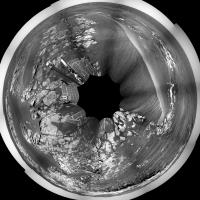
Wont post my stitch of the full 360, it's cack compared to dilos - but here's my polar of it.
Doug
Attached thumbnail(s)
|
|
|
|
|
|
|
Feb 25 2006, 01:44 PM
Post
#51
|
||
|
Senior Member Group: Members Posts: 2837 Joined: 22-April 05 From: Ridderkerk, Netherlands Member No.: 353 |
Here is the pancam L2 view.
Taken on Sol 742. jvandriel
Attached thumbnail(s)
|
|
|
|
|
|
|
Feb 25 2006, 04:56 PM
Post
#52
|
|
 Junior Member Group: Members Posts: 71 Joined: 11-May 05 From: Colorado USA Member No.: 386 |
It appears that the top layer on the cliff is the same as the evaporite layer below the cliff (that we are sitting on). There are probably a number of explanations for this, but I can think of two: 1) Subsidence, or 2) deposition after the cliff formed. In the second case, the evaporite would preferentially form on flat surfaces; any that formed on the cliff face would erode off, particularly as erosion forced the cliff to recede.
I think the cliff fairly clearly defines the Erebus crater rim, and that the evaporite clearly formed after the Erebus impact. This would argue for the scenario where the deposition occurred after the cliff formed -- and is missing from the cliff face due to erosion. Thoughts? Scott. |
|
|
|
|
Feb 25 2006, 05:02 PM
Post
#53
|
||
|
Solar System Cartographer Group: Members Posts: 10189 Joined: 5-April 05 From: Canada Member No.: 227 |
Here is my version of a polar pan (not pure polar, but with a progressively compressed foreground to better approximate map geometry)... where was I? - oh yeah - pan from Sol 742. It's from dilo's pan - which has only 9 of the 10 pics in it.
I can't claim to be as excited as Bill about this location. It looks a lot blander than Burns Cliff or Home Plate to me. An outcrop with nearly a metre of visible section is good, but will it really give us much new? Maybe the remote sensing will show something interesting. I wouldn't expect to be here very long. As for the shallowness of Erebus, another topic from above... I don't really see this as an impact into water or a crater once filled with water. I'd go for an ordinary crater in dry rock, but heavily eroded since then. It seems clear to me that the evaporite stuff we are seeing throughout this area erodes quite quickly in Martian terms - lack of blocky ejecta around all but the freshest craters, for instance, not to mention the large quantity of blueberry-containing material eroded away to create such a large lag deposit of blueberries. So I think Erebus and Terra Nova, and similar features throughout this area, are just the eroded roots of old, once-proud craters, a bit like Manicouagan in Quebec. Phil -------------------- ... because the Solar System ain't gonna map itself.
Also to be found posting similar content on https://mastodon.social/@PhilStooke Maps for download (free PD: https://upload.wikimedia.org/wikipedia/comm...Cartography.pdf NOTE: everything created by me which I post on UMSF is considered to be in the public domain (NOT CC, public domain) |
|
|
|
|
|
|
Feb 25 2006, 05:11 PM
Post
#54
|
|
|
Senior Member Group: Members Posts: 2998 Joined: 30-October 04 Member No.: 105 |
QUOTE I can't claim to be as excited as Bill about this location. It looks a lot blander than Burns Cliff or Home Plate to me It really isn't all that exciting, but is it remarkably different than anything we've seen before. It is blander than Burns Cliff, but given the eroded state of Erebus, it is remarkable. It's a geologist thing. Humor us.  Nice Polar. --Bill -------------------- |
|
|
|
|
Feb 25 2006, 06:55 PM
Post
#55
|
|
|
Junior Member Group: Members Posts: 30 Joined: 15-November 05 Member No.: 553 |
QUOTE (sranderson @ Feb 25 2006, 09:56 AM) It appears that the top layer on the cliff is the same as the evaporite layer below the cliff (that we are sitting on). There are probably a number of explanations for this, but I can think of two: 1) Subsidence, or 2) deposition after the cliff formed. In the second case, the evaporite would preferentially form on flat surfaces; any that formed on the cliff face would erode off, particularly as erosion forced the cliff to recede. I think the cliff fairly clearly defines the Erebus crater rim, and that the evaporite clearly formed after the Erebus impact. This would argue for the scenario where the deposition occurred after the cliff formed -- and is missing from the cliff face due to erosion. Thoughts? Scott. Scott: I agree that the two layers you mention are the same but I tend to lean toward subsidence along an old crater rim with the following sequence of events. First - Deposition of some layered beds second- Impact crater formed with small rim third- Erosion and filling of crater to near plane fourth- Deposition of layered Meridiani beds culminating in evaporite sequence fifth- Minor erosion and dune formation sixth- Differential subsidence along old crater rim which offsets evaporite layer |
|
|
|
|
Feb 25 2006, 07:05 PM
Post
#56
|
||
|
Senior Member Group: Members Posts: 2837 Joined: 22-April 05 From: Ridderkerk, Netherlands Member No.: 353 |
Phil,
here is the complete one. A 360 degree panoramic view on Sol 742. Taken with the L0 navcam. jvandriel
Attached thumbnail(s)
|
|
|
|
|
|
|
Feb 25 2006, 07:20 PM
Post
#57
|
|
 Senior Member Group: Moderator Posts: 3431 Joined: 11-August 04 From: USA Member No.: 98 |
Here are a couple MMB views using a de-vignetting technique I'm playing with.
 
|
|
|
|
|
Feb 25 2006, 07:26 PM
Post
#58
|
|
|
Member Group: Members Posts: 548 Joined: 19-March 05 From: Princeton, NJ, USA Member No.: 212 |
QUOTE (Shaka @ Feb 25 2006, 03:24 AM) Na, richtig toll, Mensch, gel? Endlich etwas neues !! Finally something new !! WOW. "Holy Toledo" and perhaps a few more ..... And a real drive too not just a few cm. Boy, I had to sadly do "real" work instead of "martian" work for a few days and missed this till I read the latest JPL update this morning and wandered over here. ken |
|
|
|
|
Feb 25 2006, 07:37 PM
Post
#59
|
|
 Senior Member Group: Members Posts: 1281 Joined: 18-December 04 From: San Diego, CA Member No.: 124 |
QUOTE (mhoward @ Feb 25 2006, 11:20 AM) Here are a couple MMB views using a de-vignetting technique I'm playing with. Yes, please! They look fantastic.... can we start getting our hopes up for the next release?
-------------------- Lyford Rome
"Zis is not nuts, zis is super-nuts!" Mathematician Richard Courant on viewing an Orion test |
|
|
|
|
Feb 25 2006, 07:42 PM
Post
#60
|
|
|
Member Group: Members Posts: 139 Joined: 14-October 05 From: Toronto, Canada Member No.: 529 |
QUOTE (lyford @ Feb 25 2006, 02:37 PM) Yes, please! They look fantastic.... can we start getting our hopes up for the next release? lyford, Michael has just put out a new release (1.4.4) Check it out on his web site 
-------------------- -- Robin
|
|
|
|
|

|
Lo-Fi Version | Time is now: 7th June 2024 - 10:41 PM |
|
RULES AND GUIDELINES Please read the Forum Rules and Guidelines before posting. IMAGE COPYRIGHT |
OPINIONS AND MODERATION Opinions expressed on UnmannedSpaceflight.com are those of the individual posters and do not necessarily reflect the opinions of UnmannedSpaceflight.com or The Planetary Society. The all-volunteer UnmannedSpaceflight.com moderation team is wholly independent of The Planetary Society. The Planetary Society has no influence over decisions made by the UnmannedSpaceflight.com moderators. |
SUPPORT THE FORUM Unmannedspaceflight.com is funded by the Planetary Society. Please consider supporting our work and many other projects by donating to the Society or becoming a member. |
|