Opportunity Leaves Olympia, Goodbye Purgatory 2 |

  |
Opportunity Leaves Olympia, Goodbye Purgatory 2 |
 Feb 28 2006, 01:45 AM Feb 28 2006, 01:45 AM
Post
#121
|
|
|
Member  Group: Members Posts: 713 Joined: 30-March 05 Member No.: 223 |
QUOTE (dilo @ Feb 27 2006, 11:22 PM)  In fact (very rough NavCam stitch).. impressive view ... here is a lens corrected and colorized version:  
|
 |
 
|
|
Feb 28 2006, 02:23 AM
Post
#122
|
|
 Senior Member Group: Members Posts: 1229 Joined: 24-December 05 From: The blue one in between the yellow and red ones. Member No.: 618 |
So here we are at last!
Thanks, Nirgal. The range of contrast makes it look almost 'snow-capped'. What seemed so black at a distance, apparently wasn't all that distinct from the upper part. Just lots of lamination overhangs shadowing the sides. To be honest, I can't discern more than one laminated unit in this exposure.I haven't spotted any 'festoons', either. Maybe we won't have cause to linger here long. One close-up view might tell the whole story. Anybody got other ideas? Victoria beckons! 
-------------------- My Grandpa goes to Mars every day and all I get are these lousy T-shirts!
|
|
|
|
|
Feb 28 2006, 03:00 AM
Post
#123
|
|
 Senior Member Group: Members Posts: 1281 Joined: 18-December 04 From: San Diego, CA Member No.: 124 |
Wow - that is now one of my new favorites - great job!
-------------------- Lyford Rome
"Zis is not nuts, zis is super-nuts!" Mathematician Richard Courant on viewing an Orion test |
|
|
|
|
Feb 28 2006, 03:09 AM
Post
#124
|
|
|
Senior Member Group: Members Posts: 2998 Joined: 30-October 04 Member No.: 105 |
Here is an L257 color image of the Mogollon outcrop from Sol 744. Nothing that astounding, although I did expect the bluff unit to be a bit darker than the overlying unit.
This is going to be a good area to study-- we have likely found our marker bed to correlate with. --Bill -------------------- |
|
|
|
|
Feb 28 2006, 05:12 AM
Post
#125
|
|
|
Senior Member Group: Members Posts: 1229 Joined: 24-December 05 From: The blue one in between the yellow and red ones. Member No.: 618 |
QUOTE (Bill Harris @ Feb 27 2006, 05:09 PM) Here is an L257 color image of the Mogollon outcrop from Sol 744. Nothing that astounding, although I did expect the bluff unit to be a bit darker than the overlying unit. This is going to be a good area to study-- we have likely found our marker bed to correlate with. --Bill Hey, Bill, you're teasing us non-geologists with that kind of expression. "Our marker bed to correlate with." Please, explain to us what you mean by "marker bed". How is it distinctive from lots of other laminated evaporites we've seen since touchdown? If we are confronted with a five-meter exposure of laminated evaporites at Victoria (Oh God, Please let it be!), interspersed with 'festoon beds', volcanic tuffs, and other things I can't even imagine, how will we pick out this marker? Prof. Tim, can you help out explaining to us The Erebus Story ? I do think a lecture is needed. 
-------------------- My Grandpa goes to Mars every day and all I get are these lousy T-shirts!
|
|
|
|
|
Feb 28 2006, 08:44 AM
Post
#126
|
|
|
Member Group: Members Posts: 877 Joined: 7-March 05 From: Switzerland Member No.: 186 |
Just an explanatory note: The dunes behind Mogollon rim appear higher because they are on higher ground than Oppy currently, right? They aren't such monsters as they appear
-------------------- |
|
|
|
|
Feb 28 2006, 09:18 AM
Post
#127
|
|
|
Senior Member Group: Moderator Posts: 4279 Joined: 19-April 05 From: .br at .es Member No.: 253 |
I think so.
As a side note, see what would happen if Oppy is on a leveled terrain with dunes actually high like that: A very close horizon and the view blocked by the dunes i.e. a maze. Let's hope there is nothing like that on the way to Victoria. 
|
|
|
|
|
Feb 28 2006, 09:22 AM
Post
#128
|
|
|
Founder Group: Chairman Posts: 14433 Joined: 8-February 04 Member No.: 1 |
I think actually - some of these are biggies - as big as the ones we saw before on the North rim and skirted way north around.
I don't think they'll come up to camera height - we'll always be able to see over them, but we might have difficulty in planning longer drives Doug |
|
|
|
|
Feb 28 2006, 09:39 AM
Post
#129
|
||
|
Senior Member Group: Moderator Posts: 4279 Joined: 19-April 05 From: .br at .es Member No.: 253 |
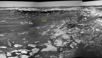
This is the current position (sol 745) as seen from the previous one (sol 742).
|
|
|
|
|
|
|
Feb 28 2006, 10:11 AM
Post
#130
|
||
 Senior Member Group: Members Posts: 2228 Joined: 1-December 04 From: Marble Falls, Texas, USA Member No.: 116 |
Finally, the sol 744 pancams I was dying to see have arrived. The dipping beds I saw in the sol 742 navcams and described in post #73 are much more evident in the pancams. Fracturing and cover still make many of the contacts difficult or impossible to follow, but the geometry of the layering is apparent. Moving from right to left across this panorama, progressively younger layers come to the surface. I've used dashed and dotted lines to highlight the attached, cropped and annotated segment of my Autostitched panorama from the sol 744 L7 images.
Attached thumbnail(s)
-------------------- ...Tom
I'm not a Space Fan, I'm a Space Exploration Enthusiast. |
|
|
|
|
|
|
Feb 28 2006, 10:37 AM
Post
#131
|
|
|
Senior Member Group: Moderator Posts: 4279 Joined: 19-April 05 From: .br at .es Member No.: 253 |
QUOTE (CosmicRocker @ Feb 28 2006, 11:11 AM) Finally, the sol 744 pancams I was dying to see have arrived. Stay tuned!  CODE 746 p2353.07 24 0 0 24 2 50 pancam_Payson_12x1_L7R1
|
|
|
|
|
Feb 28 2006, 12:03 PM
Post
#132
|
|
|
Senior Member Group: Members Posts: 2998 Joined: 30-October 04 Member No.: 105 |
Tom, the bedding geometry is quite apparent in this exposure and likely represents at least a local dip if not regional-- the orientation appears to be along the Erebus crater rim, so I don't think it reflects the upturned strata of the crater. We'll know more at the next Payson exposure, which is as prominent as this one from orbital imagery. Of equal or greater interest to me are the near-vertical joints and fractures.
>pancam_Payson_12x1_L7R1 Ah ha, so the NASA/JPL designation for this site _is_ Payson. The dunes to the West and South are higher and appear moreso due to the view from _inside of_ Erebus. I'd suspect that this is due to orographic effects from the crater rim causing more sand to be deposited. Again, if you don' t understand, Google is a lantern in the sea of enlightenment. --Bill -------------------- |
|
|
|
|
Feb 28 2006, 01:59 PM
Post
#133
|
|
 Member Group: Members Posts: 593 Joined: 20-April 05 Member No.: 279 |
QUOTE (djellison @ Feb 28 2006, 09:22 AM) I think actually - some of these are biggies - as big as the ones we saw before on the North rim and skirted way north around. Two pancam images from Sol 744 are tweened here in a Flash movie for a sense of the topography of these dunes. It's hard to triangulate to the ridge line that make up the horizon, but it looks like 150 - 200m away (with the outcrop back edge at about 40m from this vantage point). Personally, I'd leg it up a dune for a good look to the south towards Victoria to see whether this is a real high point on the road to the south, or merely a matter of viewing from a dip, but then if I'd been driving Opportunity the mission would have ended months ago... Andy |
|
|
|
|
Feb 28 2006, 05:05 PM
Post
#134
|
|
|
Junior Member Group: Members Posts: 30 Joined: 15-November 05 Member No.: 553 |
QUOTE (CosmicRocker @ Feb 28 2006, 03:11 AM) Finally, the sol 744 pancams I was dying to see have arrived. The dipping beds I saw in the sol 742 navcams and described in post #73 are much more evident in the pancams. Fracturing and cover still make many of the contacts difficult or impossible to follow, but the geometry of the layering is apparent. Moving from right to left across this panorama, progressively younger layers come to the surface. I've used dashed and dotted lines to highlight the attached, cropped and annotated segment of my Autostitched panorama from the sol 744 L7 images. Your annotated image showing the dip within the unit below the planar beds is good. IMO the subsidence is fairly recent because you can see a point along the escarpment in Nirgual's image where the lower beds form a wedge and vertical displacement dies out further to the right. Illustrated by horizontal continuity of the upper planar unit. The lack of rubble off the cliff is also further indication of its age |
|
|
|
|
Feb 28 2006, 09:18 PM
Post
#135
|
|
|
Senior Member Group: Moderator Posts: 4279 Joined: 19-April 05 From: .br at .es Member No.: 253 |
The "drive-direction" pancams from sol 745 are available at the exploratorium: http://qt.exploratorium.edu/mars/opportuni...cam/2006-02-28/
Check for yourselves, but imo Oppy will take the route to the right of Payson i.e. by the top of the rim. |
|
|
|
|

|
Lo-Fi Version | Time is now: 7th June 2024 - 02:34 PM |
|
RULES AND GUIDELINES Please read the Forum Rules and Guidelines before posting. IMAGE COPYRIGHT |
OPINIONS AND MODERATION Opinions expressed on UnmannedSpaceflight.com are those of the individual posters and do not necessarily reflect the opinions of UnmannedSpaceflight.com or The Planetary Society. The all-volunteer UnmannedSpaceflight.com moderation team is wholly independent of The Planetary Society. The Planetary Society has no influence over decisions made by the UnmannedSpaceflight.com moderators. |
SUPPORT THE FORUM Unmannedspaceflight.com is funded by the Planetary Society. Please consider supporting our work and many other projects by donating to the Society or becoming a member. |
|