Moving south to Victoria |

  |
Moving south to Victoria |
 Mar 17 2006, 12:26 PM Mar 17 2006, 12:26 PM
Post
#16
|
|
|
Senior Member  Group: Members Posts: 2998 Joined: 30-October 04 Member No.: 105 |
This is good news. I was hoping that the ripples-- driving surface, actually-- would has as good a pavement as we had during the "North Erebus Detour" or North of Purgatory 1. Keep in the ripple troughs, or the 'half tube' as the drivers call it and we should make good time.
--Bill -------------------- |
 |
 
|
|
Mar 17 2006, 03:05 PM
Post
#17
|
||
|
Solar System Cartographer Group: Members Posts: 10166 Joined: 5-April 05 From: Canada Member No.: 227 |
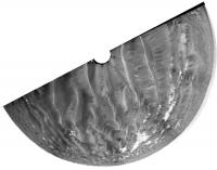
Here's Tesheiner's half-pan from 762 in my usual polar form. It's easy to match that triangular outcrop with the latest route map. Presumably we'll be on it after the next drive.
Phil
-------------------- ... because the Solar System ain't gonna map itself.
Also to be found posting similar content on https://mastodon.social/@PhilStooke Maps for download (free PD: https://upload.wikimedia.org/wikipedia/comm...Cartography.pdf NOTE: everything created by me which I post on UMSF is considered to be in the public domain (NOT CC, public domain) |
|
|
|
|
|
|
Mar 17 2006, 04:01 PM
Post
#18
|
|
|
Senior Member Group: Moderator Posts: 4279 Joined: 19-April 05 From: .br at .es Member No.: 253 |
That was the aim point since they left Erebus on sol 760.
I wonder if they will maintain the current heading (about SSE) after that outcrop or will start driving SE following the rocks... |
|
|
|
|
Mar 17 2006, 11:35 PM
Post
#19
|
|
|
Senior Member Group: Members Posts: 2998 Joined: 30-October 04 Member No.: 105 |
I suspect that they will go SSE using the rock outcrops as stepping stones whenever they can. Traveling in the troughs is not bad, but there is less uncertainty on rock. Remember that surprise that we had between South Shetland and "The Fourlane".
--Bill -------------------- |
|
|
|
| Guest_Sunspot_* |
Mar 18 2006, 01:12 PM
Post
#20
|
|
Guests |
I'm assuming Opportunity is in restricted sols at the moment... any idea how many more days it will last?
|
|
|
|
|
Mar 18 2006, 05:03 PM
Post
#21
|
|
|
Senior Member Group: Moderator Posts: 4279 Joined: 19-April 05 From: .br at .es Member No.: 253 |
Given the current timing Meridiani/JPL I would say Oppy is no longer on restricted sols. However, it's a weekend.
 I just checked the tracking web and tomorrow (Sunday) will be driving day. |
|
|
|
|
Mar 18 2006, 08:50 PM
Post
#22
|
|
|
Member Group: Members Posts: 477 Joined: 2-March 05 Member No.: 180 |
QUOTE (Tesheiner @ Mar 17 2006, 05:08 AM)  Oppy drove some 50m southwards (heading ~160º) on sol 762 and is currently at aprox. 25m of the outcrop on the center of this navcam pano. [attachment=4577:attachment] (195k) Check out the bottom right of this panorama. More mini-craters. Closeup One on the far left of this picture Visible here, lower right, with a cosmic ray hit right near it. |
|
|
|
|
Mar 19 2006, 07:48 AM
Post
#23
|
|
|
Junior Member Group: Members Posts: 25 Joined: 20-April 05 From: Japan Member No.: 283 |
Well and truly leaving Erebus behind now. Looks like they made the right decision to explore the west rim rather than take the shorter east rim route south- not much to see from here
http://qt.exploratorium.edu/mars/opportuni...RXP1795L0M1.JPG |
|
|
|
|
Mar 19 2006, 02:39 PM
Post
#24
|
|
|
Junior Member Group: Members Posts: 35 Joined: 8-July 05 Member No.: 432 |
QUOTE (Tesheiner @ Mar 18 2006, 12:03 PM) Given the current timing Meridiani/JPL I would say Oppy is no longer on restricted sols. However, it's a weekend. I just checked the tracking web and tomorrow (Sunday) will be driving day. I am very impressed by these 50M drives, I was expecting something in the 30m distance per drive sol. Is there an simple relationship between drive distance and drive time, based on start/stops for autonav? |
|
|
|
|
Mar 19 2006, 08:24 PM
Post
#25
|
|
|
Member Group: Members Posts: 477 Joined: 2-March 05 Member No.: 180 |
I figure it has to do with the fact that they've got more experience driving, and the time spent at the various Purgatories has helped the drivers learn how to drive the rover more efficiently. And with better dune-detection parameters on the wheels (I guess it goes based on resistance), the rover can decide for itself if it's going into dangerous territory.
|
|
|
|
|
Mar 19 2006, 09:22 PM
Post
#26
|
|
|
Founder Group: Chairman Posts: 14432 Joined: 8-February 04 Member No.: 1 |
As I understand it - every X metres, the rover does a single visidom to measure actual progress compared to commanded progress. If there's above Y% slip, the drive aborts.
Doug |
|
|
|
|
Mar 19 2006, 10:49 PM
Post
#27
|
|
 Senior Member Group: Moderator Posts: 3431 Joined: 11-August 04 From: USA Member No.: 98 |
Pretty picture from Sol 758: (2x2 Pancam L257 false-color)
 
|
|
|
|
|
Mar 20 2006, 01:58 PM
Post
#28
|
|
|
Senior Member Group: Moderator Posts: 4279 Joined: 19-April 05 From: .br at .es Member No.: 253 |
Another step on the way to Victoria.
Oppy drove about 45m on sol 765, up to the far edge of that triangular outcrop seen on 762 images. |
|
|
|
|
Mar 20 2006, 03:29 PM
Post
#29
|
|
|
Member Group: Members Posts: 252 Joined: 27-April 05 Member No.: 365 |
She didn't take any navcam pics of the track behind her and the sun was relatively high when the cameras were going so I am a little disorientated after this weekends' drive. Would this be the view in the direction of Victoria?
http://qt.exploratorium.edu/mars/opportuni...YQP0695L0M1.JPG In any case, it is clear she is moving onto higher ground as the horizon is getting a bit further away, and the dunes in the immediate area look easy. Directly south, though, it looks more rugged: http://qt.exploratorium.edu/mars/opportuni...YQP0695L0M1.JPG |
|
|
|
|
Mar 20 2006, 03:58 PM
Post
#30
|
|
|
Founder Group: Chairman Posts: 14432 Joined: 8-February 04 Member No.: 1 |
Oh - a full Navcam pan will have been taken at the end of the drive, but the forward facing images are a higher priority than the backward facing ones, so they'll come down overnight or tomorrow.
Doug |
|
|
|
|

|
Lo-Fi Version | Time is now: 23rd May 2024 - 09:02 PM |
|
RULES AND GUIDELINES Please read the Forum Rules and Guidelines before posting. IMAGE COPYRIGHT |
OPINIONS AND MODERATION Opinions expressed on UnmannedSpaceflight.com are those of the individual posters and do not necessarily reflect the opinions of UnmannedSpaceflight.com or The Planetary Society. The all-volunteer UnmannedSpaceflight.com moderation team is wholly independent of The Planetary Society. The Planetary Society has no influence over decisions made by the UnmannedSpaceflight.com moderators. |
SUPPORT THE FORUM Unmannedspaceflight.com is funded by the Planetary Society. Please consider supporting our work and many other projects by donating to the Society or becoming a member. |
|