First HiRISE Images Coming Soon!, test images to be taken week of March 20 |

  |
First HiRISE Images Coming Soon!, test images to be taken week of March 20 |
 Mar 24 2006, 09:16 PM Mar 24 2006, 09:16 PM
Post
#106
|
||
 Senior Member  Group: Members Posts: 2488 Joined: 17-April 05 From: Glasgow, Scotland, UK Member No.: 239 |
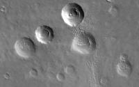
I think it's at least in part due to local dust conditions - look at this crop from the first MRO image of an area where the winds don't appear to be depositing as much material in the lee of various surface features.
Bob Shaw
Attached thumbnail(s)
-------------------- Remember: Time Flies like the wind - but Fruit Flies like bananas!
|
|
 |
 
|
|
|
Mar 24 2006, 09:21 PM
Post
#107
|
|
|
Founder Group: Chairman Posts: 14432 Joined: 8-February 04 Member No.: 1 |
I can see the joins
 Doug |
|
|
|
|
Mar 24 2006, 09:31 PM
Post
#108
|
|
|
Senior Member Group: Members Posts: 2488 Joined: 17-April 05 From: Glasgow, Scotland, UK Member No.: 239 |
Doug:
Joking aside, I swear I saw a join on the first release image, too! BTW, the HiROC site says 'The camera will take a second set of Mars images Saturday morning, March 25. These are test images and may not be of interest to the public.' Bob Shaw -------------------- Remember: Time Flies like the wind - but Fruit Flies like bananas!
|
|
|
|
|
Mar 24 2006, 09:41 PM
Post
#109
|
|
 Senior Member Group: Moderator Posts: 3233 Joined: 11-February 04 From: Tucson, AZ Member No.: 23 |
Non-Martian geologist alert. Read at your own risk.
Started looking through this first image and there are a few features that stand out. BTW, the central feature in this image is the north-south trending scarp just right of center called Ogygis Rupes. First up are the promient east to west trending channels: http://pirlwww.lpl.arizona.edu/~perry/Channel.jpg . This is a close-up (well, actually full-res) view of one of them. Now the channels here are very interesting. On the south side are inactive, transverse dunes (I assume inactive since a few dunes have small impact craters on them). just north of the center line of the channels is a smooth area, and on the north slope is some kind of blocky layer. Now, these north-slope blocky areas is a running theme in this region through the first hirise image. Relatively featureless south slopes, blocky north slopes. Now, combine this with the layers we see in the release full-res sample image from earlier in the day, and you get this sense that this is a layered region with perhaps tilted layers with a generally east-west strike with a dip presumably toward the southwest, thus the blocky stuff comes from one layer, and the more massive, smooth appear layer appears on top. As you go more toward the northwest, the blocky stuff is more exposed until you hit Ogygis Rupes. Complicating this is the topography which runs downhill from east to west. Regardless, an interesting area. Here's a look at a more broadly exposed area of blocky terrain: http://pirlwww.lpl.arizona.edu/~perry/Rootless_cone.jpg . Here we see small hills, 50-100 meters in size. The small-scale roughness is much greater than in the previous area. Just above and to the right of center, we see a pit at the top of a hill. Rootless cone maybe? Or a crater where the surrounding rock has been eroded away? Finally, we have a 4.5 km wide crater near the right edge of the swath: http://pirlwww.lpl.arizona.edu/~perry/4.5km_crater.jpg . here again we see a depression, a crater this time, with a rough north side and a dust-covered south side. Could this be due to preferential aeolian deposition? Very odd. Regardless, a very interesting area. -------------------- &@^^!% Jim! I'm a geologist, not a physicist!
The Gish Bar Times - A Blog all about Jupiter's Moon Io |
|
|
|
|
Mar 24 2006, 09:41 PM
Post
#110
|
|
|
Founder Group: Chairman Posts: 14432 Joined: 8-February 04 Member No.: 1 |
Hmm - dark side perhaps for noise? Or badly smeared for flat fielding?
Doug |
|
|
|
| Guest_AlexBlackwell_* |
Mar 24 2006, 09:53 PM
Post
#111
|
|
Guests |
QUOTE (volcanopele @ Mar 24 2006, 09:41 PM)  Non-Martian geologist alert. Read at your own risk. Is this your analysis? |
|
|
|
|
Mar 24 2006, 09:59 PM
Post
#112
|
|
|
Senior Member Group: Moderator Posts: 3233 Joined: 11-February 04 From: Tucson, AZ Member No.: 23 |
Actually, it is from my evil twin who likes Mars.
 Why what't wrong with it? other than the fact that it doesn't really say anything substative? -------------------- &@^^!% Jim! I'm a geologist, not a physicist!
The Gish Bar Times - A Blog all about Jupiter's Moon Io |
|
|
|
|
Mar 24 2006, 10:29 PM
Post
#113
|
|
|
Senior Member Group: Members Posts: 1276 Joined: 25-November 04 Member No.: 114 |
QUOTE (centsworth_II @ Mar 24 2006, 11:38 AM) Hey, you few (I hope) who find reason to complain: What are you going to do for the NEXT SIX MONTHS? Listen to Hogland complain about six months of pictures that JPL is stealing and miss leading the rest of us.  Kidding aside, I was tired and grumpy. I just wanted to see the pictures. 
|
|
|
|
| Guest_AlexBlackwell_* |
Mar 24 2006, 10:40 PM
Post
#114
|
|
Guests |
QUOTE (volcanopele @ Mar 24 2006, 09:59 PM) Why what't wrong with it? other than the fact that it doesn't really say anything substative? Nothing, as far as I can tell. However, that doesn't mean a whole lot since, if truth be told, I haven't even looked at the image closely enough to comment. I just wanted to make sure whose analysis it was up front in case I do have any comments. In other words, I didn't want a "Moomaw"-type response to any comments/criticisms (viz., "Well, Alex, I ran my interpretation by Scientist X and he agrees with everything I said."
|
|
|
|
|
Mar 24 2006, 10:59 PM
Post
#115
|
|
|
Junior Member Group: Members Posts: 91 Joined: 27-January 05 From: Arlington, Virginia Member No.: 159 |
Tried to find the location in the MEX HRSC archives, but it falls neatly in a sliver of uncovered territory between two huge images.
|
|
|
|
|
Mar 24 2006, 11:26 PM
Post
#116
|
|
|
Senior Member Group: Moderator Posts: 3233 Joined: 11-February 04 From: Tucson, AZ Member No.: 23 |
QUOTE (AlexBlackwell @ Mar 24 2006, 03:40 PM) Nothing, as far as I can tell. However, that doesn't mean a whole lot since, if truth be told, I haven't even looked at the image closely enough to comment. I just wanted to make sure whose analysis it was up front in case I do have any comments. In other words, I didn't want a "Moomaw"-type response to any comments/criticisms (viz., "Well, Alex, I ran my interpretation by Scientist X and he agrees with everything I said." Alex, it's Mars. I fully admit ignorance. If I am wrong, it is okay!! -------------------- &@^^!% Jim! I'm a geologist, not a physicist!
The Gish Bar Times - A Blog all about Jupiter's Moon Io |
|
|
|
| Guest_BillyMER_* |
Mar 24 2006, 11:45 PM
Post
#117
|
|
Guests |
I don't think it's been said enough in this thread,these first photos are spectacular,unbelievable ! What endless knowledge to be gained from photos of this quality.
It would be interesting to see a before and after pic,like the best photo taken from this piece of Mars with one of the other orbiters. |
|
|
|
|
Mar 24 2006, 11:55 PM
Post
#118
|
|
|
Founder Group: Chairman Posts: 14432 Joined: 8-February 04 Member No.: 1 |
Well - MOC imagery would exceed this resolution - but we've not found any overlapping parts yet. It's bound to be in some Themis VIS images at 18m/pixel though - to this HiRISE imagery is 6x better than that.
This imageyr is utterly superb news not because of the image itself, but because it means the camera works properly, in the right sort of environment, doing what it was designed to do. It means that, aerobraking allowing, we're going to have some really very very good imagery in a few months time Do we know if they took the blue-green or near-IR with this test run? Perhaps they're saving the release of that for the mars madia event mentioned at the HiRISE website. Doug |
|
|
|
|
Mar 25 2006, 12:14 AM
Post
#119
|
|
|
Member Group: Members Posts: 688 Joined: 20-April 05 From: Sweden Member No.: 273 |
QUOTE (volcanopele @ Mar 24 2006, 10:41 PM) Here's a look at a more broadly exposed area of blocky terrain: http://pirlwww.lpl.arizona.edu/~perry/Rootless_cone.jpg . Here we see small hills, 50-100 meters in size. The small-scale roughness is much greater than in the previous area. Just above and to the right of center, we see a pit at the top of a hill. Rootless cone maybe? Or a crater where the surrounding rock has been eroded away? Finally, we have a 4.5 km wide crater near the right edge of the swath: http://pirlwww.lpl.arizona.edu/~perry/4.5km_crater.jpg . here again we see a depression, a crater this time, with a rough north side and a dust-covered south side. Could this be due to preferential aeolian deposition? Very odd. Regardless, a very interesting area. To me the whole area seems strongly eroded by wind, which has preferentially removed softer sediments leaving the harder "knobbly" material. The "Rootless cone" is probably a pedestal crater where the softer material around it has been removed. Apparently the south side of craters and channels are the lee side and dust settles there. tty |
|
|
|
|
Mar 25 2006, 12:36 AM
Post
#120
|
|
 Chief Assistant Group: Admin Posts: 1409 Joined: 5-January 05 From: Ierapetra, Greece Member No.: 136 |
QUOTE (djellison @ Mar 25 2006, 12:55 AM) ............ It's bound to be in some Themis VIS images at 18m/pixel though - to this HiRISE imagery is 6x better than that. ........... Doug Here's one for context -roughly north-south context, about 1/3 down the image. http://themis-data.asu.edu/img/I14731003.html Nico and right next to it; http://themis-data.asu.edu/img/I15043004.html -------------------- photographer, space imagery enthusiast, proud father and partner, and geek.
http://500px.com/sacred-photons & |
|
|
|
|

|
Lo-Fi Version | Time is now: 29th April 2024 - 08:55 AM |
|
RULES AND GUIDELINES Please read the Forum Rules and Guidelines before posting. IMAGE COPYRIGHT |
OPINIONS AND MODERATION Opinions expressed on UnmannedSpaceflight.com are those of the individual posters and do not necessarily reflect the opinions of UnmannedSpaceflight.com or The Planetary Society. The all-volunteer UnmannedSpaceflight.com moderation team is wholly independent of The Planetary Society. The Planetary Society has no influence over decisions made by the UnmannedSpaceflight.com moderators. |
SUPPORT THE FORUM Unmannedspaceflight.com is funded by the Planetary Society. Please consider supporting our work and many other projects by donating to the Society or becoming a member. |
|