Opportunity Route Map |

  |
Opportunity Route Map |
 Apr 5 2006, 03:07 PM Apr 5 2006, 03:07 PM
Post
#1201
|
|
|
Solar System Cartographer  Group: Members Posts: 10170 Joined: 5-April 05 From: Canada Member No.: 227 |
Well... that got such a good response that I will post my Spirit map in a similar format... maybe later today, and in the appropriate thread.
Phil -------------------- ... because the Solar System ain't gonna map itself.
Also to be found posting similar content on https://mastodon.social/@PhilStooke Maps for download (free PD: https://upload.wikimedia.org/wikipedia/comm...Cartography.pdf NOTE: everything created by me which I post on UMSF is considered to be in the public domain (NOT CC, public domain) |
 |
 
|
|
Apr 5 2006, 03:23 PM
Post
#1202
|
|
|
Junior Member Group: Members Posts: 45 Joined: 25-March 05 Member No.: 216 |
Very very nice new map!!!!
Thanks!!! -------------------- My Open Office Website: http://www.openofficetips.com
|
|
|
|
|
Apr 5 2006, 03:52 PM
Post
#1203
|
|
|
Senior Member Group: Members Posts: 1636 Joined: 9-May 05 From: Lima, Peru Member No.: 385 |
Phil, a very nice and descriptive Spirit transverse.
 I would like to suggest you to include the traveled distance in meters at every sol points so that I can update weekly an outlook about the probably arriving date on Victoria Crater according to the present peace advancement. That kind is good for Oppy instead of Spirit since it is in cruise stage. Rodolfo |
|
|
|
|
Apr 5 2006, 05:29 PM
Post
#1204
|
|
 Senior Member Group: Members Posts: 2488 Joined: 17-April 05 From: Glasgow, Scotland, UK Member No.: 239 |
Phil:
Great maps - they really bring out just how far Opportunity has travelled. Bob Shaw -------------------- Remember: Time Flies like the wind - but Fruit Flies like bananas!
|
|
|
|
|
Apr 5 2006, 06:16 PM
Post
#1205
|
|
 Member Group: Members Posts: 221 Joined: 25-March 05 Member No.: 217 |
Lovely map Phil hopefully it will get a lot longer and it will eventually be nice to scroll down past Victoria.
Roy F
|
|
|
|
|
Apr 5 2006, 06:20 PM
Post
#1206
|
|
|
Senior Member Group: Members Posts: 2998 Joined: 30-October 04 Member No.: 105 |
What a stroll down Memory Lane! The map detail adds to the warm-and-fuzzy feeling.
The coordinates are set on a 100m grid with the lander at the origin. Do you have secondary control points to the south at Erebus, etc, or are you placing the individual maps on a best-fit basis on the grid? --Bill -------------------- |
|
|
|
|
Apr 5 2006, 06:39 PM
Post
#1207
|
|
 Senior Member Group: Admin Posts: 4763 Joined: 15-March 05 From: Glendale, AZ Member No.: 197 |
QUOTE (Phil Stooke @ Apr 5 2006, 03:02 AM)  The attached image Fantastic Phil! Pour yourself a Labatt's on me! -------------------- If Occam had heard my theory, things would be very different now.
|
|
|
|
|
Apr 5 2006, 06:53 PM
Post
#1208
|
|
|
Solar System Cartographer Group: Members Posts: 10170 Joined: 5-April 05 From: Canada Member No.: 227 |
Bill asked about the grid.
All I'm doing is placing a 100 m grid over one of the map-projected MOC images, after scaling it to the pixel size I want to use. There is no more control than that, nor is any more really feasible given the available information. Somebody suggested adding lat-long coordinates. I could, but the location of this area (or any place on Mars) relative to the lat-long grid is still uncertain. I'm not up to date with the uncertainties - somebody might look that up for me. Rodolpho suggested adding distance labels. I think I'll leave that for somebody else! Phil -------------------- ... because the Solar System ain't gonna map itself.
Also to be found posting similar content on https://mastodon.social/@PhilStooke Maps for download (free PD: https://upload.wikimedia.org/wikipedia/comm...Cartography.pdf NOTE: everything created by me which I post on UMSF is considered to be in the public domain (NOT CC, public domain) |
|
|
|
|
Apr 5 2006, 07:07 PM
Post
#1209
|
|
 Member Group: Members Posts: 562 Joined: 29-March 05 Member No.: 221 |
QUOTE (ElkGroveDan @ Apr 5 2006, 07:39 PM) Fantastic Phil! Pour yourself a Labatt's on me! I don't think that reads exactly as you planned  oo-er matron |
|
|
|
|
Apr 5 2006, 07:57 PM
Post
#1210
|
|
|
Solar System Cartographer Group: Members Posts: 10170 Joined: 5-April 05 From: Canada Member No.: 227 |
oo-er matron is right! If I had that Labatt's I could think of better things to do with it than pour it over ElkGroveDan. I live in the home town of Labatt's, in London Ontario... but unfortunately I'm more of a wino myself.
What I didn't say about the maps is that they are a sort of proof of concept thing for a future atlas of Mars exploration. Each 500 m square would be one page, with room for a bit of text. Places which needed extra detail - like Eagle crater - would get additional maps like those I posted elsewhere in this MER section. Phil -------------------- ... because the Solar System ain't gonna map itself.
Also to be found posting similar content on https://mastodon.social/@PhilStooke Maps for download (free PD: https://upload.wikimedia.org/wikipedia/comm...Cartography.pdf NOTE: everything created by me which I post on UMSF is considered to be in the public domain (NOT CC, public domain) |
|
|
|
|
Apr 5 2006, 08:05 PM
Post
#1211
|
|
 Member Group: Members Posts: 103 Joined: 12-February 05 From: Utah Member No.: 167 |
Great map Phil. Thanks! I look forward to seeing your Spirit route map also.
-------------------- - My signature idea machine is busted right now.
|
|
|
|
|
Apr 5 2006, 08:33 PM
Post
#1212
|
|
|
Member Group: Members Posts: 562 Joined: 29-March 05 Member No.: 221 |
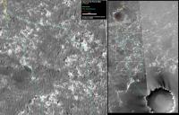
QUOTE (Phil Stooke @ Apr 5 2006, 08:57 PM) Places which needed extra detail - like Eagle crater - would get additional maps like those I posted elsewhere in this MER section This is what Phil was referring to. |
|
|
|
|
Apr 5 2006, 08:39 PM
Post
#1213
|
|
 Dublin Correspondent Group: Admin Posts: 1799 Joined: 28-March 05 From: Celbridge, Ireland Member No.: 220 |
QUOTE (Phil Stooke @ Apr 5 2006, 06:53 PM) Somebody suggested adding lat-long coordinates. I could, but the location of this area (or any place on Mars) relative to the lat-long grid is still uncertain. I'm not up to date with the uncertainties - somebody might look that up for me. Mike Caplinger has been involved in some work to reduce that uncertainty. The uncertainty seems to be 0.004deg or around 250m unless someone has improved on that in the meantime. |
|
|
|
|
Apr 5 2006, 09:47 PM
Post
#1214
|
||
|
Senior Member Group: Moderator Posts: 4279 Joined: 19-April 05 From: .br at .es Member No.: 253 |
An updated route map after today's (sol 781) drive.
As already noted, Oppy is moving quite fast and was almost at the bottom of the map's background image, so it was time to shift the picture up. Here is the result.
|
|
|
|
|
|
|
Apr 6 2006, 12:53 AM
Post
#1215
|
|
 Member Group: Members Posts: 267 Joined: 5-February 06 Member No.: 675 |
QUOTE (helvick @ Apr 5 2006, 03:39 PM) Mike Caplinger has been involved in some work to reduce that uncertainty. Rushing in where angels fear to tread, don't we have more precise initial positions for the rovers from delay/doppler measurements on the direct to earth links and the Odyssey relay passes. (No, I can't find the references). As I understand it, this ties the rover's landing points pretty well to the defined rotational coordinates of Mars and to inertial space.The uncertainty seems to be 0.004deg or around 250m unless someone has improved on that in the meantime. Relating those positions to points on the ground is another matter. Waiting to be corrected once more. |
|
|
|
|

|
Lo-Fi Version | Time is now: 28th May 2024 - 02:57 AM |
|
RULES AND GUIDELINES Please read the Forum Rules and Guidelines before posting. IMAGE COPYRIGHT |
OPINIONS AND MODERATION Opinions expressed on UnmannedSpaceflight.com are those of the individual posters and do not necessarily reflect the opinions of UnmannedSpaceflight.com or The Planetary Society. The all-volunteer UnmannedSpaceflight.com moderation team is wholly independent of The Planetary Society. The Planetary Society has no influence over decisions made by the UnmannedSpaceflight.com moderators. |
SUPPORT THE FORUM Unmannedspaceflight.com is funded by the Planetary Society. Please consider supporting our work and many other projects by donating to the Society or becoming a member. |
|