Opportunity Route Map |

  |
Opportunity Route Map |
 Apr 6 2006, 01:09 AM Apr 6 2006, 01:09 AM
Post
#1216
|
|
|
Solar System Cartographer  Group: Members Posts: 10166 Joined: 5-April 05 From: Canada Member No.: 227 |
Steve, you are basically right. The other tie between surface features and inertial space is MOLA. But overall it may not be much more accurate than the few hundred meters already quoted. That may improve with later analysis but I'm not sure how much of it has been done yet.
Phil -------------------- ... because the Solar System ain't gonna map itself.
Also to be found posting similar content on https://mastodon.social/@PhilStooke Maps for download (free PD: https://upload.wikimedia.org/wikipedia/comm...Cartography.pdf NOTE: everything created by me which I post on UMSF is considered to be in the public domain (NOT CC, public domain) |
 |
 
|
|
Apr 6 2006, 01:36 PM
Post
#1217
|
|
|
Founder Group: Chairman Posts: 14432 Joined: 8-February 04 Member No.: 1 |
MERB UHF Tracking data
http://anserver1.eprsl.wustl.edu/anteam/merb/merb.htm I've whacked some of that into Excel in the past, it's interesting to watch the signal drop out during occultation by things like the LGA, PCMA etc. Phil - do you know of a scale for your 2k x 2k endurance map? I've finally got round to trying to overlay the mobility plots onto it and I'm not quite sure how accurate I'm being  Doug |
|
|
|
|
Apr 6 2006, 05:25 PM
Post
#1218
|
|
 Junior Member Group: Members Posts: 29 Joined: 6-April 06 From: Finland > Turku Member No.: 733 |
what you think from this> http://marsrovers.nasa.gov/gallery/all/1/n...FWP1907R0M1.JPG
Sol 776 nav cam is that small crater? |
|
|
|
|
Apr 6 2006, 05:44 PM
Post
#1219
|
|
 Senior Member Group: Members Posts: 2492 Joined: 15-January 05 From: center Italy Member No.: 150 |
FIN Mars, look at the dedicated thread:
http://www.unmannedspaceflight.com/index.p...indpost&p=49130 -------------------- I always think before posting! - Marco -
|
|
|
|
|
Apr 6 2006, 09:05 PM
Post
#1220
|
||
|
Senior Member Group: Moderator Posts: 4279 Joined: 19-April 05 From: .br at .es Member No.: 253 |
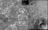
Route map, updated to sol 782.
|
|
|
|
|
|
|
Apr 7 2006, 10:52 AM
Post
#1221
|
||
|
Junior Member Group: Members Posts: 29 Joined: 6-April 06 From: Finland > Turku Member No.: 733 |
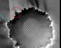
way to wictoria?
Attached thumbnail(s)
|
|
|
|
|
|
|
Apr 7 2006, 11:43 AM
Post
#1222
|
|
|
Senior Member Group: Moderator Posts: 4279 Joined: 19-April 05 From: .br at .es Member No.: 253 |
Note that the entry paths to the crater by the northern rim have a southern slope.
Even if Oppy is almost at the equator, I fear those slopes would be "no go" due to the same reasons Spirit is currently looking for a "winter's quarter". |
|
|
|
|
Apr 7 2006, 12:01 PM
Post
#1223
|
|
|
Founder Group: Chairman Posts: 14432 Joined: 8-February 04 Member No.: 1 |
The raised rim near the approach will be NW facing, and the ramps down into the crater will be south facing - ish...so there's a slope for every season
Doug |
|
|
|
|
Apr 7 2006, 12:12 PM
Post
#1224
|
|
|
Member Group: Members Posts: 252 Joined: 27-April 05 Member No.: 365 |
I would expect they will go right up to the edge wherever they can along the north side, get some good sun and take a -lot- of images of the rim and inner bowl. Then they will plot a route around to the south side that keeps the rover flat or north-tilted before finding an entry path.
|
|
|
|
|
Apr 7 2006, 12:51 PM
Post
#1225
|
|
 Senior Member Group: Members Posts: 1088 Joined: 19-February 05 From: Close to Meudon Observatory in France Member No.: 172 |
QUOTE (FIN Mars @ Apr 7 2006, 12:52 PM)  way to wictoria? This descent path was named "Boat Ramp" by the MER team a year ago...
|
|
|
|
|
Apr 7 2006, 07:39 PM
Post
#1226
|
|
 Senior Member Group: Members Posts: 1229 Joined: 24-December 05 From: The blue one in between the yellow and red ones. Member No.: 618 |
QUOTE (vikingmars @ Apr 7 2006, 02:51 AM) This descent path was named "Boat Ramp" by the MER team a year ago... And I'm sure there is no doubt that once we start down it we will be 'launched' into Victoria Crater. The only uncertainty is whether we will conclude the launch right-side-up or upside-down.  Can we tell the slope of the inside walls now? Presumably when we get there. -------------------- My Grandpa goes to Mars every day and all I get are these lousy T-shirts!
|
|
|
|
|
Apr 7 2006, 08:40 PM
Post
#1227
|
|
|
Newbie Group: Members Posts: 14 Joined: 4-April 06 From: San Francisco, CA Member No.: 732 |
A geologist acquaintence who works on the MER project referred to the camp who favors entering Victoria at all costs as the "Thelma and Louise crowd". He actually counted himself in this group.
|
|
|
|
|
Apr 7 2006, 08:43 PM
Post
#1228
|
|
|
Founder Group: Chairman Posts: 14432 Joined: 8-February 04 Member No.: 1 |
I remember seing a presentation by Tim Parker that described Victoria as a suitable 'end of mission' location. It's a sad thought - but it's a sensible proposition - you could spend a year inside Victoria alone - a couple of nice pans from around the interior - a fitting end. There's nothing that realistically could be pinned to the map as a suitable location after Victoria to be honest.
Doug |
|
|
|
|
Apr 7 2006, 08:53 PM
Post
#1229
|
|
|
Senior Member Group: Members Posts: 2921 Joined: 14-February 06 From: Very close to the Pyrénées Mountains (France) Member No.: 682 |
QUOTE (djellison @ Apr 7 2006, 10:43 PM) There's nothing that realistically could be pinned to the map as a suitable location after Victoria to be honest. Doug A agree too but, "what if" Oppy is still around after they decide that they know enough about VC ? When we 'll get there, we'll have to start a new pool "How long will we stay at Victoria" 
-------------------- |
|
|
|
|
Apr 7 2006, 09:38 PM
Post
#1230
|
|
 Member Group: Members Posts: 362 Joined: 12-June 05 From: Kiama, Australia Member No.: 409 |
QUOTE (climber @ Apr 8 2006, 06:53 AM) A agree too but, "what if" Oppy is still around after they decide that they know enough about VC ? When we 'll get there, we'll have to start a new pool "How long will we stay at Victoria" I think the trip in will be a one way trip |
|
|
|
|

|
Lo-Fi Version | Time is now: 23rd May 2024 - 10:54 PM |
|
RULES AND GUIDELINES Please read the Forum Rules and Guidelines before posting. IMAGE COPYRIGHT |
OPINIONS AND MODERATION Opinions expressed on UnmannedSpaceflight.com are those of the individual posters and do not necessarily reflect the opinions of UnmannedSpaceflight.com or The Planetary Society. The all-volunteer UnmannedSpaceflight.com moderation team is wholly independent of The Planetary Society. The Planetary Society has no influence over decisions made by the UnmannedSpaceflight.com moderators. |
SUPPORT THE FORUM Unmannedspaceflight.com is funded by the Planetary Society. Please consider supporting our work and many other projects by donating to the Society or becoming a member. |
|