Moon Images By SMART-1 |

  |
Moon Images By SMART-1 |
| Guest_DonPMitchell_* |
 Jun 2 2006, 11:25 PM Jun 2 2006, 11:25 PM
Post
#91
|
|
Guests |
I'm waiting for the altimetry data from LRO! It's remarkable that we have better data for Mars than we do for the Moon. How good will the SMART images be, and what will the total coverage be? How will it compare to the Clementine mapping?
To me, the intertesting thing about SMART-1 was the ion propulsion. It was the second spacecraft to really use ion engines to get somewhere. Deep Space-1 used an American electrostatic ion engine, SMART-1 uses a Russian Hall-effect engine. The SPD engines (statzionariykh plazmennykh dvigatelyakh )were pioneered by OKB Fakel in the early 1970s, used for station keeping of Meteor and Yamal satellites. Their most powerful engines can produce up to 80 gram-force of thrust and a specific impulse of 3000 sec. That's almost 10 times more efficiency than chemical rocket engines (whcih max out around 400 sec for the best of them). The Phobos-Grunt mission will contain 3 of the SPD-140 engines. Keeping my fingers crossed that mission will really happen (and actually work). |
 |
 
|
| Guest_BruceMoomaw_* |
Jun 3 2006, 05:03 AM
Post
#92
|
|
Guests |
Resolution of the Clementine cameras at its periapsis of 425 km was 115 m/pixel for the UV/visible camera (6 bands), 178m for the near-IR camera (6 bands), 65 m for the 1-band long-IR camera, and 30 m for the camera associated with the Lidar (5 bands). That periapsis was moved from 30 deg S to 30 deg N over the mission. Apoapsis was 8300 km.
Resolution of SMART-1's AMIE camera (3 bands, all within the range of Clementine's UV/visible camera) at its periapsis of 300 km is 27 m/pixel. Apoapsis is 3000 km. Periapsis was left at the south pole during the primary mission, but has now been moved to 30 deg S. Area coverage by the two missions can perhaps be guessed at from these figures -- obviously they've covered the Moon's southern hemisphere much better than its northern one. As for Clementine's Lidar coverage, there's an excellent summary at http://nssdc.gsfc.nasa.gov/database/Master...=1994-004A&ex=4 . Personally, I'm a lot more interested in seeing the results from SMART's near-IR spectrometer (never taken to the Moon before) and its X-ray spectrometer (first map outside a narrow equatorial zone). |
|
|
|
| Guest_DonPMitchell_* |
Jun 3 2006, 08:27 AM
Post
#93
|
|
Guests |
QUOTE (BruceMoomaw @ Jun 2 2006, 10:03 PM)  Resolution of the Clementine cameras at its periapsis of 425 km was 115 m/pixel for the UV/visible camera (6 bands), 178m for the near-IR camera (6 bands), 65 m for the 1-band long-IR camera, and 30 m for the camera associated with the Lidar (5 bands). That periapsis was moved from 30 deg S to 30 deg N over the mission. Apoapsis was 8300 km. Resolution of SMART-1's AMIE camera (3 bands, all within the range of Clementine's UV/visible camera) at its periapsis of 300 km is 27 m/pixel. Apoapsis is 3000 km. Periapsis was left at the south pole during the primary mission, but has now been moved to 30 deg S. Area coverage by the two missions can perhaps be guessed at from these figures -- obviously they've covered the Moon's southern hemisphere much better than its northern one. As for Clementine's Lidar coverage, there's an excellent summary at http://nssdc.gsfc.nasa.gov/database/Master...=1994-004A&ex=4 . Personally, I'm a lot more interested in seeing the results from SMART's near-IR spectrometer (never taken to the Moon before) and its X-ray spectrometer (first map outside a narrow equatorial zone). Thanks. I've looked at the Clementine LIDAR data. It is too course to be of much use for bumpmapping. |
|
|
|
|
Jun 3 2006, 12:43 PM
Post
#94
|
|
 Senior Member  Group: Members Posts: 2530 Joined: 20-April 05 Member No.: 321 |
QUOTE (ugordan @ Jun 2 2006, 02:10 AM) I have a better candidate -- why don't we attack, for example, the VIMS instrument' s team aboard Cassini instead? I don't see all too many releases from an instrument that supposedly has better visibility through Titan's haze than ISS, but that doesn't seem to bother anyone. http://www.unmannedspaceflight.com/index.p...indpost&p=45962 |
|
|
|
|
Jun 30 2006, 11:54 PM
Post
#95
|
|
 Senior Member Group: Members Posts: 2488 Joined: 17-April 05 From: Glasgow, Scotland, UK Member No.: 239 |
A sudden flurry of activity at last from ESA, demonstrating that they had the images all the time:
http://www.esa.int/esaSC/SEMN1GL8IOE_index_0.html There's 136 images in that movie alone - more than we've seen to date. Bob Shaw -------------------- Remember: Time Flies like the wind - but Fruit Flies like bananas!
|
|
|
|
|
Jul 1 2006, 06:58 AM
Post
#96
|
|
|
Senior Member Group: Members Posts: 2530 Joined: 20-April 05 Member No.: 321 |
QUOTE (Bob Shaw @ Jun 30 2006, 04:54 PM) A sudden flurry of activity at last from ESA, demonstrating that they had the images all the time: Imagine if these top-secret images of the Moon had been leaked early. Anarchy! |
|
|
|
|
Jul 1 2006, 07:30 AM
Post
#97
|
||
 Senior Member Group: Members Posts: 2492 Joined: 15-January 05 From: center Italy Member No.: 150 |
Damn, Bob, you're right!
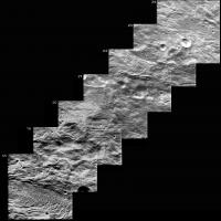
 They say: "From these distances, a series of images could be obtained with some overlap between them, that allowed to build a mosaic during a good part of the orbit". Partial result should be something like this:
These are only 7 frames (I excluded very first ones due to heavy over-exposure); some enlargement was needed on first ones, so spacecraft was in the approaching phase of it's elongated orbit (1000x5000 Km). Any volunteer wants to complete this work for entire orbit? 
-------------------- I always think before posting! - Marco -
|
|
|
|
|
|
|
Jul 1 2006, 08:34 AM
Post
#98
|
||
|
Senior Member Group: Members Posts: 2492 Joined: 15-January 05 From: center Italy Member No.: 150 |
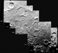
...and this is the final portion, showing north polar region between Carpenter and Goja craters:
Attached thumbnail(s)
-------------------- I always think before posting! - Marco -
|
|
|
|
|
|
|
Jul 1 2006, 01:49 PM
Post
#99
|
|
|
Senior Member Group: Members Posts: 2488 Joined: 17-April 05 From: Glasgow, Scotland, UK Member No.: 239 |
QUOTE (dilo @ Jul 1 2006, 09:34 AM) ...and this is the final portion, showing north polar region between Carpenter and Goja craters: Marco: Good stuff! It's sad that we're reduced to silly things like frame-grabbing, but at least there's something there for us to play with at last. Bob Shaw -------------------- Remember: Time Flies like the wind - but Fruit Flies like bananas!
|
|
|
|
|
Aug 10 2006, 05:05 AM
Post
#100
|
||
|
Senior Member Group: Members Posts: 2492 Joined: 15-January 05 From: center Italy Member No.: 150 |
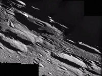
An oblique look on the north lunar far west:
http://www.esa.int/SPECIALS/SMART-1/SEM787BUQPE_1.html Here below an enhanced version (note the strange solarization effect on bright features around the low/left missec box)
Attached thumbnail(s)
-------------------- I always think before posting! - Marco -
|
|
|
|
|
|
|
Nov 3 2006, 02:40 PM
Post
#101
|
||
|
Solar System Cartographer Group: Members Posts: 10153 Joined: 5-April 05 From: Canada Member No.: 227 |
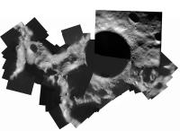
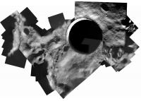
A new SMART-1 image was released recently:
http://www.esa.int/SPECIALS/SMART-1/SEMP7QOFHTE_0.html It shows Shackleton crater at the South Pole. Here I have added it in to an earlier mosaic of Clementine HIRES camera images. It fills a gap not well seen by Clementine. The big black circle is Shackleton, and Earth is towards the top. Phil
-------------------- ... because the Solar System ain't gonna map itself.
Also to be found posting similar content on https://mastodon.social/@PhilStooke Maps for download (free PD: https://upload.wikimedia.org/wikipedia/comm...Cartography.pdf NOTE: everything created by me which I post on UMSF is considered to be in the public domain (NOT CC, public domain) |
|
|
|
|
|
|
May 18 2007, 12:55 PM
Post
#102
|
|
|
Solar System Cartographer Group: Members Posts: 10153 Joined: 5-April 05 From: Canada Member No.: 227 |
-------------------- ... because the Solar System ain't gonna map itself.
Also to be found posting similar content on https://mastodon.social/@PhilStooke Maps for download (free PD: https://upload.wikimedia.org/wikipedia/comm...Cartography.pdf NOTE: everything created by me which I post on UMSF is considered to be in the public domain (NOT CC, public domain) |
|
|
|
|
Nov 7 2007, 06:42 PM
Post
#103
|
|
 Member Group: Members Posts: 124 Joined: 23-March 06 Member No.: 723 |
Reuters is carrying a story about a new German orbiter
Germany plans unmanned lunar orbit http://www.reuters.com/article/scienceNews...=22&sp=true "The project would be called LEO -- Lunar Exploration Orbiter -- and could be fired into space in 2012 if decisions are made and sufficient financing found, Hintze said. He said initial costs for the project would be around 350 million euros ($513.6 million), which would cover the planning, building and launch of the spacecraft. " QUOTE "A lunar mission would be a building block and would not be against Europe or against cooperation," he said, adding that the Germans had discussed the project with NASA, ESA and the Russian Space Agency.
|
|
|
|
|
Nov 8 2007, 09:23 PM
Post
#104
|
||
|
Solar System Cartographer Group: Members Posts: 10153 Joined: 5-April 05 From: Canada Member No.: 227 |
Another version of the South Pole mosaic above. Another Smart-1 image has been added to my Clementine High Resolution base.
Phil
-------------------- ... because the Solar System ain't gonna map itself.
Also to be found posting similar content on https://mastodon.social/@PhilStooke Maps for download (free PD: https://upload.wikimedia.org/wikipedia/comm...Cartography.pdf NOTE: everything created by me which I post on UMSF is considered to be in the public domain (NOT CC, public domain) |
|
|
|
|
|
|
Dec 30 2007, 01:53 AM
Post
#105
|
|
 Senior Member Group: Members Posts: 1887 Joined: 20-November 04 From: Iowa Member No.: 110 |
ESA has released a mosaic of the north pole.
http://www.esa.int/SPECIALS/SMART-1/SEMMH029R9F_0.html |
|
|
|
|

|
Lo-Fi Version | Time is now: 27th April 2024 - 11:45 AM |
|
RULES AND GUIDELINES Please read the Forum Rules and Guidelines before posting. IMAGE COPYRIGHT |
OPINIONS AND MODERATION Opinions expressed on UnmannedSpaceflight.com are those of the individual posters and do not necessarily reflect the opinions of UnmannedSpaceflight.com or The Planetary Society. The all-volunteer UnmannedSpaceflight.com moderation team is wholly independent of The Planetary Society. The Planetary Society has no influence over decisions made by the UnmannedSpaceflight.com moderators. |
SUPPORT THE FORUM Unmannedspaceflight.com is funded by the Planetary Society. Please consider supporting our work and many other projects by donating to the Society or becoming a member. |
|