My personnal MER 3d software |

  |
My personnal MER 3d software |
 Aug 6 2006, 04:10 AM Aug 6 2006, 04:10 AM
Post
#106
|
|
 Senior Member  Group: Members Posts: 2228 Joined: 1-December 04 From: Marble Falls, Texas, USA Member No.: 116 |
Indian3000: If it wouldn't be too much trouble
 , could you say more about controls in the DEM viewer, and how to use other DEMs, textures, etc, if that can be done. Are there controls in the DEM viewer other than the left and right mouse controls? Can other CUB files and textures be used, or is that something you have planned for a future release? , could you say more about controls in the DEM viewer, and how to use other DEMs, textures, etc, if that can be done. Are there controls in the DEM viewer other than the left and right mouse controls? Can other CUB files and textures be used, or is that something you have planned for a future release?
-------------------- ...Tom
I'm not a Space Fan, I'm a Space Exploration Enthusiast. |
 |
 
|
|
Aug 7 2006, 11:29 AM
Post
#107
|
|
 Member Group: Members Posts: 239 Joined: 20-April 05 From: Bruxelles, Belgium Member No.: 278 |
CosmicRocker: You do'nt bother me
DEM viewer controls are only mouse right and left click , wheel mouse, Arrow key, F4 Wireframe/ solid draw and H key to hide/show crosshair the majority of the parameters are hardcoded in my program. To make a simple interface which charges the various parameters will not be easy. Nothing is automatic and the various parameters to match the textures to the model are computed by hand. I could make a thiny interface to enter the various parameters but I must then make a little tutorial. -------------------- |
|
|
|
|
Aug 8 2006, 03:21 AM
Post
#108
|
||
|
Senior Member Group: Members Posts: 2228 Joined: 1-December 04 From: Marble Falls, Texas, USA Member No.: 116 |
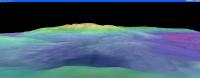
Ahh! Thank you. In retrospect I suppose I should have been able to figure most of those out, but knowing those controls helps me agreat deal. I should have at least tried the mouse wheel! I now have learned that the figure rotates around the + point, and that by panning the image below it in plan view before changing the perspective, I can more easily manipulate the view to achieve almost the results I want. I couldn't make it display the exact view of the inner basin from the top of Husband Hill, but the attached image is an approximation of it.
I see that it would be difficult to program an interface for other models and textures, but this is very nice as it is. I have also used your ant-vignetting module and I wanted to mention that I love it. The ability to batch process images and save with automatic renaming is very convenient. -------------------- ...Tom
I'm not a Space Fan, I'm a Space Exploration Enthusiast. |
|
|
|
|
|
|
Aug 8 2006, 02:09 PM
Post
#109
|
|||
|
Member Group: Members Posts: 239 Joined: 20-April 05 From: Bruxelles, Belgium Member No.: 278 |
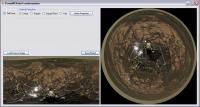
Polar Projection Preview
I still need to add some parameters, and corrects some bugs before making a release.
-------------------- |
||
|
|
|
||
|
Aug 9 2006, 09:13 PM
Post
#110
|
|
|
Senior Member Group: Members Posts: 2228 Joined: 1-December 04 From: Marble Falls, Texas, USA Member No.: 116 |
That looks interesting.
...kind of like Phil, in a box... 
-------------------- ...Tom
I'm not a Space Fan, I'm a Space Exploration Enthusiast. |
|
|
|
|
Aug 9 2006, 09:26 PM
Post
#111
|
|
|
Solar System Cartographer Group: Members Posts: 10153 Joined: 5-April 05 From: Canada Member No.: 227 |
I will be in a box if this goes on...
Very nice stuff, Indian3000. Your contributions are really useful and greatly appreciated, I'm sure. Phil -------------------- ... because the Solar System ain't gonna map itself.
Also to be found posting similar content on https://mastodon.social/@PhilStooke Maps for download (free PD: https://upload.wikimedia.org/wikipedia/comm...Cartography.pdf NOTE: everything created by me which I post on UMSF is considered to be in the public domain (NOT CC, public domain) |
|
|
|
|
Aug 10 2006, 12:03 PM
Post
#112
|
|||
|
Member Group: Members Posts: 239 Joined: 20-April 05 From: Bruxelles, Belgium Member No.: 278 |
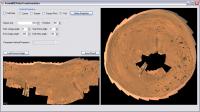
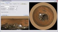
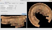
MarsRoverCenterPolarTransform Release R1
 MarsRoverCenterPolarTransform_R1.zip ( 193K )
Number of downloads: 429
MarsRoverCenterPolarTransform_R1.zip ( 193K )
Number of downloads: 429
just load source image and press Make projection, you can play with differents parameters ...
-------------------- |
||
|
|
|
||
|
Aug 10 2006, 02:21 PM
Post
#113
|
||
|
Solar System Cartographer Group: Members Posts: 10153 Joined: 5-April 05 From: Canada Member No.: 227 |
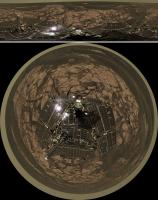
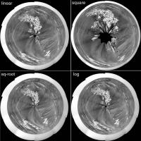
Well, I just had to try this out. It's great. Here is a pan from sol 829 reprojected four times using each of the four geometric options, to show the difference.
(PS I did nothing to the original pan, but for better results I should have added some space at the bottom, creating a blank area in the middle) The way I usually make my polars stretches out the distant detail a bit more than this. But this is very nice indeed. Thanks, Indian3000. Now I'm going to have to try out your other stuff! Phil -------------------- ... because the Solar System ain't gonna map itself.
Also to be found posting similar content on https://mastodon.social/@PhilStooke Maps for download (free PD: https://upload.wikimedia.org/wikipedia/comm...Cartography.pdf NOTE: everything created by me which I post on UMSF is considered to be in the public domain (NOT CC, public domain) |
|
|
|
|
|
|
Aug 10 2006, 02:24 PM
Post
#114
|
|
|
Founder Group: Chairman Posts: 14432 Joined: 8-February 04 Member No.: 1 |
[alan sugar]
Phil, You're fired [/alan sugar] Doug |
|
|
|
|
Aug 10 2006, 02:27 PM
Post
#115
|
|
|
Solar System Cartographer Group: Members Posts: 10153 Joined: 5-April 05 From: Canada Member No.: 227 |
Oh, OK... do I get a golden handshake?
Phil -------------------- ... because the Solar System ain't gonna map itself.
Also to be found posting similar content on https://mastodon.social/@PhilStooke Maps for download (free PD: https://upload.wikimedia.org/wikipedia/comm...Cartography.pdf NOTE: everything created by me which I post on UMSF is considered to be in the public domain (NOT CC, public domain) |
|
|
|
|
Aug 10 2006, 02:36 PM
Post
#116
|
||
|
Member Group: Members Posts: 239 Joined: 20-April 05 From: Bruxelles, Belgium Member No.: 278 |
QUOTE (Phil Stooke @ Aug 10 2006, 04:21 PM)  Well, I just had to try this out. It's great. Here is a pan from sol 829 reprojected four times using each of the four geometric options, to show the difference.
(PS I did nothing to the original pan, but for better results I should have added some space at the bottom, creating a blank area in the middle) The way I usually make my polars stretches out the distant detail a bit more than this. But this is very nice indeed. Thanks, Indian3000. Now I'm going to have to try out your other stuff! Phil hi phil, I think that incrementing the option "Start theta angle" you will arrive at the good result if I understood well ,
-------------------- |
|
|
|
|
|
|
Aug 10 2006, 03:01 PM
Post
#117
|
|
 Member Group: Members Posts: 562 Joined: 29-March 05 Member No.: 221 |
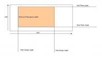
It needs a space adding along the bottom equal to the width of the deck
|
|
|
|
|
Aug 10 2006, 03:06 PM
Post
#118
|
|
|
Member Group: Members Posts: 239 Joined: 20-April 05 From: Bruxelles, Belgium Member No.: 278 |
QUOTE (paxdan @ Aug 10 2006, 05:01 PM) It needs a space adding along the bottom equal to the width of the deck use option "Start theta angle" -------------------- |
|
|
|
|
Aug 10 2006, 04:00 PM
Post
#119
|
||
|
Member Group: Members Posts: 239 Joined: 20-April 05 From: Bruxelles, Belgium Member No.: 278 |
perhaps that this can explain part of the options
-------------------- |
|
|
|
|
|
|
Aug 11 2006, 12:23 AM
Post
#120
|
|||
 Senior Member Group: Members Posts: 1619 Joined: 12-February 06 From: Bergerac - FR Member No.: 678 |
Great job!
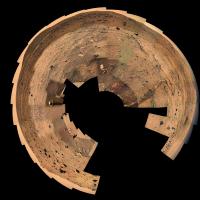
 I've download it and the way of using is very intuitive. Thanks! Here is a try with my own MacMurdo pan :
Attached thumbnail(s)
-------------------- |
||
|
|
|
||
|

|
Lo-Fi Version | Time is now: 28th April 2024 - 11:47 AM |
|
RULES AND GUIDELINES Please read the Forum Rules and Guidelines before posting. IMAGE COPYRIGHT |
OPINIONS AND MODERATION Opinions expressed on UnmannedSpaceflight.com are those of the individual posters and do not necessarily reflect the opinions of UnmannedSpaceflight.com or The Planetary Society. The all-volunteer UnmannedSpaceflight.com moderation team is wholly independent of The Planetary Society. The Planetary Society has no influence over decisions made by the UnmannedSpaceflight.com moderators. |
SUPPORT THE FORUM Unmannedspaceflight.com is funded by the Planetary Society. Please consider supporting our work and many other projects by donating to the Society or becoming a member. |
|