Opportunity Route Map |

  |
Opportunity Route Map |
 Aug 30 2006, 09:34 AM Aug 30 2006, 09:34 AM
Post
#1846
|
|
 Senior Member  Group: Members Posts: 2492 Joined: 15-January 05 From: center Italy Member No.: 150 |
Nice work, algorimancer. This route map is quite familiar
 and strongly recall also "official" JPL maps... and strongly recall also "official" JPL maps...Anyway, in order to have a better surface visibility in each vertical projection, I suggest you to "equalize" illumination in the various directions. Moreover, Sol914 projection show the horizon and probably needs a tilt correction (this is partiall true also for Sol916). -------------------- I always think before posting! - Marco -
|
 |
 
|
|
Aug 30 2006, 12:45 PM
Post
#1847
|
|
 Member Group: Members Posts: 656 Joined: 20-April 05 From: League City, Texas Member No.: 285 |
QUOTE (dilo @ Aug 30 2006, 04:34 AM)  Nice work, algorimancer. This route map is quite familiar and strongly recall also "official" JPL maps...Anyway, in order to have a better surface visibility in each vertical projection, I suggest you to "equalize" illumination in the various directions. Moreover, Sol914 projection show the horizon and probably needs a tilt correction (this is partiall true also for Sol916). Thank you. Equaling illumination is a good idea, I suppose I was being lazy. The problem with the horizon on Sol's 914 and 916 is apparently related to the reset that occured around that time, throwing-off the rover's orientation quaternion. I'm not sure that there's anything I can do about that, as my technique is entirely dependent upon that information (I have no means of adjusting per the horizon, I'm completely dependent upon the camera pointing information and rover orientation quaterion, unlike your POV-Ray approach). It appears to only affect the images from the northeast quadrant, which I don't understand. Anyway, I would be inclined to trust Phil Stooke's and Tesheiner's pre-Sol 917 positions more than my own. You might try a planar projection using POV-Ray for the Sol 919 position, and see whether you come up with an equivalent position. [edit]Upon further investigation I'm beginning to suspect that the projection went awry on (at least) the Sol 914 and 916 sites, perhaps the others as well. Looks like it picked-up some tilt from somewhere (in my code I think). Doesn't seem to invalidate the Sol 917+ positions, but the projections are definitely problematic. [edit again]Nope, my code seems fine. Looks like the problem is either that the rover is sitting on a 1 1/2 degree slope on those two occasions, or the rover orientation quaternion is off by that much on those occasions. Conceivably I could add a correction based on measured horizon elevations at particular azimuths. |
|
|
|
|
Sep 5 2006, 07:49 AM
Post
#1848
|
||
|
Senior Member Group: Moderator Posts: 4279 Joined: 19-April 05 From: .br at .es Member No.: 253 |
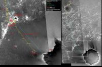
An updated route map for sol 929.
Note that I corrected the route path since (and including) sol 914 drive. Those points were all strictly based on the own rover's movement data and were day by day drifting from what we could calculate by triangulation. Now that Oppy is right beside Now I think it's time to shift the map. This post has been edited by Tesheiner: Sep 5 2006, 08:42 AM |
|
|
|
|
|
|
Sep 5 2006, 08:28 AM
Post
#1849
|
|
|
Member Group: Members Posts: 236 Joined: 21-June 05 Member No.: 417 |
QUOTE (Tesheiner @ Sep 5 2006, 09:49 AM) An updated route map for sol 929. [attachment=7281:attachment] Note that I corrected the route path since (and including) sol 914 drive. Those points were all strictly based on the own rover's movement data and were day by day drifting from what we could calculate by triangulation. Now that Oppy is right beside Now I think it's time to shift the map. guess there's a little typo on your map: "920" should be "930". 
|
|
|
|
|
Sep 5 2006, 08:45 AM
Post
#1850
|
|
|
Senior Member Group: Moderator Posts: 4279 Joined: 19-April 05 From: .br at .es Member No.: 253 |
Oooops, thanks for the info general.
I've just updated my previous post with the corrected driving sol, which btw was 929 and neither 920 or 930. 
|
|
|
|
|
Sep 5 2006, 11:58 AM
Post
#1851
|
|
|
Junior Member Group: Members Posts: 64 Joined: 24-May 06 From: Aberdeen, Scotland Member No.: 785 |
QUOTE (Tesheiner @ Sep 5 2006, 08:49 AM) Now I think it's time to shift the map. Hey Tesheiner - I've just realised that when you shift the map we won't need your blue line any more! How long have we been following your blue line! Thanks for your work (and others) keeping us up-to-date with the route. Castor |
|
|
|
|
Sep 5 2006, 12:34 PM
Post
#1852
|
||
|
Senior Member Group: Moderator Posts: 4279 Joined: 19-April 05 From: .br at .es Member No.: 253 |
Here is a preview at half-size. I would like to use as background a non-annotated version of that nice hi-res image (S11-00471) used by Tim Parker but afaik it won't be released until October.
And about the path in cyan, of course it doesn't make sense to be kept after reaching the rim. |
|
|
|
|
|
|
Sep 5 2006, 04:20 PM
Post
#1853
|
|
|
Senior Member Group: Members Posts: 2921 Joined: 14-February 06 From: Very close to the Pyrénées Mountains (France) Member No.: 682 |
QUOTE (Tesheiner @ Sep 5 2006, 02:34 PM) Here is a preview at half-size. I would like to use as background a non-annotated version of that nice hi-res image (S11-00471) used by Tim Parker but afaik it won't be released until October. And about the path in cyan, of course it doesn't make sense to be kept after reaching the rim. BTW, why don't you also correct the Beacon position on the F.. R.. ? 
-------------------- |
|
|
|
|
Sep 6 2006, 03:45 AM
Post
#1854
|
|
|
XYL Code Genius Group: Members Posts: 138 Joined: 23-November 05 Member No.: 566 |
QUOTE (Tesheiner @ Sep 5 2006, 03:49 AM) Now I think it's time to shift the map. Can you update the right part before shifting the map? |
|
|
|
|
Sep 6 2006, 07:34 AM
Post
#1855
|
|
|
Senior Member Group: Moderator Posts: 4279 Joined: 19-April 05 From: .br at .es Member No.: 253 |
I usually update the right part only when shifting the left one because it takes me a lot of time.
The reason is that the picture and the whole route you see on the right is a 1/4-size snapshot of the complete route map I have on a separate and *huge* Photoshop (like) file which my computer can barely handle, so I don't change it so often. What I can do is to keep posting the "pre-shift" version until reaching the rim but with the right image updated exactly as you can see on the "post-shift" version. |
|
|
|
|
Sep 6 2006, 03:15 PM
Post
#1856
|
|
|
Junior Member Group: Members Posts: 64 Joined: 24-May 06 From: Aberdeen, Scotland Member No.: 785 |
Tesheiner,
It's a pity that the join between the two MOC images is very close to the crater rim that the rover will reach soon. I can see you've tried to stitch the images along a line near the crater edge. Perhaps it would be better to use one image alone rather than stitch two together for this next section, although I'm sure you know better than I do about what is most suitable. Maybe even that labelled, but higher res, image that JPL have released would be more useful for now until we can get a clean copy in a month or two. Castor |
|
|
|
|
Sep 6 2006, 05:18 PM
Post
#1857
|
||
 Senior Member Group: Members Posts: 1619 Joined: 12-February 06 From: Bergerac - FR Member No.: 678 |
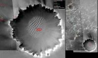
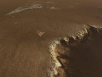
Just for a bit of fun, an aerial view of the travel of Oppy on sol 928. You can see the tracks and the rover near Epsilon Crater
 . And the vertical projection by Indian3000. . And the vertical projection by Indian3000.
-------------------- |
|
|
|
|
|
|
Sep 6 2006, 05:35 PM
Post
#1858
|
|
 Member Group: Members Posts: 578 Joined: 5-November 04 From: Denmark Member No.: 107 |
QUOTE (Ant103 @ Sep 6 2006, 07:18 PM) Just for a bit of fun, an aerial view of the travel of Oppy on sol 928. You can see the tracks and the rover near Epsilon Crater . And the vertical projection by Indian3000.Woah!   That's really great! We're so close! -------------------- "I want to make as many people as possible feel like they are part of this adventure. We are going to give everybody a sense of what exploring the surface of another world is really like"
- Steven Squyres |
|
|
|
|
Sep 6 2006, 05:36 PM
Post
#1859
|
|
 Chief Assistant Group: Admin Posts: 1409 Joined: 5-January 05 From: Ierapetra, Greece Member No.: 136 |
I love it.. nice work guys!
Nico -------------------- photographer, space imagery enthusiast, proud father and partner, and geek.
http://500px.com/sacred-photons & |
|
|
|
|
Sep 6 2006, 06:05 PM
Post
#1860
|
|
|
XYL Code Genius Group: Members Posts: 138 Joined: 23-November 05 Member No.: 566 |
QUOTE (Tesheiner @ Sep 6 2006, 03:34 AM) What I can do is to keep posting the "pre-shift" version until reaching the rim but with the right image updated exactly as you can see on the "post-shift" version. Yes, that would be great. See, with your current method when you have a lot of info on the left, there is not enough on the right. But when there is a lot info on the right, finally, you shift the map, and we get very little on the left. It would be great if you'd update the right side just before shifting the map. That way we'd get at least one picture with lots of info on both sides. |
|
|
|
|

|
Lo-Fi Version | Time is now: 26th May 2024 - 04:37 PM |
|
RULES AND GUIDELINES Please read the Forum Rules and Guidelines before posting. IMAGE COPYRIGHT |
OPINIONS AND MODERATION Opinions expressed on UnmannedSpaceflight.com are those of the individual posters and do not necessarily reflect the opinions of UnmannedSpaceflight.com or The Planetary Society. The all-volunteer UnmannedSpaceflight.com moderation team is wholly independent of The Planetary Society. The Planetary Society has no influence over decisions made by the UnmannedSpaceflight.com moderators. |
SUPPORT THE FORUM Unmannedspaceflight.com is funded by the Planetary Society. Please consider supporting our work and many other projects by donating to the Society or becoming a member. |
|