Getting to 'Big Crater', A little premature speculation |

  |
Getting to 'Big Crater', A little premature speculation |
 Sep 23 2006, 10:19 PM Sep 23 2006, 10:19 PM
Post
#76
|
||
 Member  Group: Members Posts: 656 Joined: 20-April 05 From: League City, Texas Member No.: 285 |
Does anyone know what minerals are being highlighted in these THEMIS images?
I've looked all over the THEMIS site and am unable to find any mention of it. |
|
 |
 
|
|
|
Sep 24 2006, 03:53 AM
Post
#77
|
|
|
Member Group: Senior Member Posts: 136 Joined: 8-August 06 Member No.: 1022 |
QUOTE (algorimancer @ Sep 23 2006, 01:27 PM)  I found an MOC image that goes right through the middle of Big Crater (BC): http://www.msss.com/moc_gallery/e07_e12/im...1/E1101328.html Here's the hi-res version (not map projected). The north edge of the crater is a little above half-way down the image strip (wedge-shaped ridge, with point towards the left), the south edge is a crescent shaped ridge near the bottom of the image. http://www.msss.com/moc_gallery/e07_e12/fu...11/E1101328.jpg And finally, here's a labeled clip of that same image, clipped to exclude most of the region beyond BC. [attachment=7610:attachment] There's some weird stuff going on in the southern portion of BC. The material is darker than elsewhere. What the heck are those black, channel-like features? I would guess shadows of ridges and fault lines, but I'd like to hear from someone with more geology experience than I have. Further to the south are hints of extensive layering. This place gets more interesting the more I look at it. We may just need to send MSL here if Oppy can't make it. The portion that's darkest is on the slope of the "outcrop" where it drops off about 400 meters from the center of the crater to the south floor. THe dark features are dunes. -Tim. |
|
|
|
|
Sep 24 2006, 11:33 AM
Post
#78
|
|
 Member Group: Members Posts: 813 Joined: 8-February 04 From: Arabia Terra Member No.: 12 |
I think the trickiest issue for the planners would be coming up with a driving strategy for the etched terrain that is suitably aggressive but can also avoid/correct for getting stuck in drifts.
It would take the rover 400 sols to cover 12km if it moves at an average speed of 30m per sol. Can this be done on the etched terrain? Maybe with a cycle of single sol 90m 'mostly blind' drives followed by two sols allocated to drift extraction (if needed). |
|
|
|
|
Sep 24 2006, 02:45 PM
Post
#79
|
|
|
Member Group: Members Posts: 530 Joined: 21-March 06 From: Canada Member No.: 721 |
QUOTE (SFJCody @ Sep 24 2006, 06:33 AM) I think the trickiest issue for the planners would be coming up with a driving strategy for the etched terrain that is suitably aggressive but can also avoid/correct for getting stuck in drifts. This pales in comparison to the much bigger problem facing the members of this forum... How do you tell when you've arrived at Big Crater so someone can win the inevitable arrival poll? This issue alone could give the JPL planners second thoughts about attempting such folly. Brian |
|
|
|
|
Sep 25 2006, 12:43 PM
Post
#80
|
|
 Special Cookie Group: Members Posts: 2168 Joined: 6-April 05 From: Sintra | Portugal Member No.: 228 |
QUOTE (tim53 @ Sep 22 2006, 07:23 PM) Yeah! Launching MSL!  -Tim. Huumm...So what you are saying is that we now have two alternatives for Oppy... Roving towards the Big Crater or be headed for the MSL landing site and cover it live for us folks back here on good old mother Earth?... 
-------------------- "Ride, boldly ride," The shade replied, "If you seek for Eldorado!"
Edgar Alan Poe |
|
|
|
|
Sep 25 2006, 10:14 PM
Post
#81
|
||
|
Member Group: Members Posts: 111 Joined: 14-March 05 From: Vastitas Borealis Member No.: 193 |
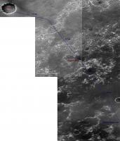
On the excuse that the subtitle of this thread is 'premature speculation' I dare to present a premature routemap for the MER drivers. I went to the MOC gallery and found two narrow angle images adjacent to and east of S0500863, which cover the most part of the area between Victoria and the Big Crater (or Ithaca, as suggested):
http://www.msss.com/moc_gallery/e19_r02/im...3/E2301344.html http://www.msss.com/moc_gallery/e01_e06/im...5/E0502642.html To build this map I stitched the non-map-projected jpegs that are a bit 'flattened' but just therefore quite suitable for this purpose (though I had to hammer Victoria a bit flatter also). Below only the southern part shrunk to 60%, but it's still large (~1 Mb). I think I found a relatively dune-free path for Oppy, so if she were driving say 200 m every other sol, she could reach 'Ithaca' around the Christmas 2007, after completing studies in Victoria next September. 
Attached thumbnail(s)
|
|
|
|
|
|
| Guest_Bobby_* |
Sep 26 2006, 12:29 AM
Post
#82
|
|
Guests |
Stay Tuned for upcoming event's.
Beacon 2 Poll for Big Crater Details to come
|
|
|
|
|
Sep 26 2006, 12:47 PM
Post
#83
|
|
|
Member Group: Members Posts: 656 Joined: 20-April 05 From: League City, Texas Member No.: 285 |
Just at the moment I'm a bit conflicted as to where to target in BC. Climbing to the top of one of the rim hills would yield one heck of a panorama, but considering how long it took Spirit to climb into the Columbia Hills, as well as the wear-and-tear (broken wheel) on the rover, it may be wisest to drive around the hills and target the (lake?) deposits at the southern portion of BC.
|
|
|
|
|
Sep 26 2006, 03:09 PM
Post
#84
|
|
|
Solar System Cartographer Group: Members Posts: 10153 Joined: 5-April 05 From: Canada Member No.: 227 |
marswiggle's mosaic is nice. I'd never looked out in that direction before but I was very interested to see a new type of terrain in the lower right corner. The surface is smooth and dark with numerous clearly defined (but very shallow) craters. The etched terrain had many vaguely circular markings, a lot of which were probably the scars of old eroded craters. But this new area looks different. So I think it would be worth looking at this area - about half way to the big crater - if such an extended mission were to be undertaken. (I'm not actually expecting anything after Victoria).
Phil -------------------- ... because the Solar System ain't gonna map itself.
Also to be found posting similar content on https://mastodon.social/@PhilStooke Maps for download (free PD: https://upload.wikimedia.org/wikipedia/comm...Cartography.pdf NOTE: everything created by me which I post on UMSF is considered to be in the public domain (NOT CC, public domain) |
|
|
|
|
Sep 26 2006, 04:06 PM
Post
#85
|
||
|
Member Group: Members Posts: 656 Joined: 20-April 05 From: League City, Texas Member No.: 285 |
QUOTE (marswiggle @ Sep 25 2006, 05:14 PM) On the excuse that the subtitle of this thread is 'premature speculation' I dare to present a premature routemap ... In a broader sense, saving the hill climbing for late in the process to preserve rover health and maximize science opportunities, I would envision something like this:
This doesn't account for the dune orientation, which would undoubtedly lead to a lot of fine adjustments. |
|
|
|
|
|
|
Sep 26 2006, 04:18 PM
Post
#86
|
|
|
Senior Member Group: Members Posts: 2920 Joined: 14-February 06 From: Very close to the Pyrénées Mountains (France) Member No.: 682 |
QUOTE (algorimancer @ Sep 26 2006, 06:06 PM) In a broader sense, saving the hill climbing for late in the process to preserve rover health and maximize science opportunities, I would envision something like this: This doesn't account for the dune orientation, which would undoubtedly lead to a lot of fine adjustments. It makes sense. Since the begining of Oppy's journey we're going down and down so, it'll be very important to explore features above what we've seen so far. But, what I can't believe is that you've got project AFTER big crater. Good on you.
-------------------- |
|
|
|
|
Sep 26 2006, 05:17 PM
Post
#87
|
|
|
Member Group: Members Posts: 656 Joined: 20-April 05 From: League City, Texas Member No.: 285 |
QUOTE (climber @ Sep 26 2006, 11:18 AM) But, what I can't believe is that you've got project AFTER big crater. Good on you. There's some really cool stuff further south, including a couple of more BIG craters, and one or two old riverbeds. Sure it's not likely that we'll get that far, but who knows? Oppy may still be limping along 10 years from now. I think that after Victoria we could get to a point where we just trust the rover's navigation software to do what it's there for and just drive and cope with the terrain as needed - perhaps routine 100-300 meter drives every day or two. |
|
|
|
|
Sep 26 2006, 06:27 PM
Post
#88
|
|
|
Junior Member Group: Members Posts: 66 Joined: 26-May 06 Member No.: 790 |
QUOTE (algorimancer @ Sep 26 2006, 10:17 AM) perhaps routine 100-300 meter drives every day or two. That would be sweet, but I wonder if the large dark region in the center of the big crater is an Ultreya-like dune field that might be pretty much impassable to Oppy. Hard to tell at the resolution of that part of the image. We should be so lucky that the terrain inside the big crater becomes a problem! |
|
|
|
|
Sep 26 2006, 06:33 PM
Post
#89
|
|
|
Founder Group: Chairman Posts: 14432 Joined: 8-February 04 Member No.: 1 |
QUOTE (algorimancer @ Sep 26 2006, 06:17 PM) 100-300 meter drives every day or two. The absolute record, with perfect terrain and a 100% healthy vehicle is 220. With half the power, one broken steering actuator.... I would aruge that the very most we could dream of is 150m in any one sol. Doug |
|
|
|
|
Sep 26 2006, 06:45 PM
Post
#90
|
|
 Senior Member Group: Members Posts: 2530 Joined: 20-April 05 Member No.: 321 |
QUOTE (Phil Stooke @ Sep 26 2006, 08:09 AM) So I think it would be worth looking at this area - about half way to the big crater - if such an extended mission were to be undertaken. (I'm not actually expecting anything after Victoria). Phil If there's no route into Victoria, it would shorten the stay there and boost the chances of something beyond there -- for good or for bad. |
|
|
|
|

|
Lo-Fi Version | Time is now: 29th April 2024 - 05:23 PM |
|
RULES AND GUIDELINES Please read the Forum Rules and Guidelines before posting. IMAGE COPYRIGHT |
OPINIONS AND MODERATION Opinions expressed on UnmannedSpaceflight.com are those of the individual posters and do not necessarily reflect the opinions of UnmannedSpaceflight.com or The Planetary Society. The all-volunteer UnmannedSpaceflight.com moderation team is wholly independent of The Planetary Society. The Planetary Society has no influence over decisions made by the UnmannedSpaceflight.com moderators. |
SUPPORT THE FORUM Unmannedspaceflight.com is funded by the Planetary Society. Please consider supporting our work and many other projects by donating to the Society or becoming a member. |
|