Getting into Victoria crater, Finding the right place & knowing Oppy's abilities |

  |
Getting into Victoria crater, Finding the right place & knowing Oppy's abilities |
 Sep 27 2006, 08:01 PM Sep 27 2006, 08:01 PM
Post
#1
|
||
|
Senior Member  Group: Members Posts: 2921 Joined: 14-February 06 From: Very close to the Pyrénées Mountains (France) Member No.: 682 |
We'll not know all the possible places to rove down into Victoria before having a complete view from different angles. Anyway, we can already see that the far rim slopes look very sandy and can only hope the near rim behave better. It's not only a matter of % of the slopes but also about drivability i.e. hard surface instead of sand. Most of the discussions with the pictures we have today are about going/not going inside. I thought we need a thread for this and also think that we can post here all the studies and teh video that have been done when Oppy was about to enter Endurance.
As a start, and to challenge the idea, I (re)post what I think could be a ramp to enter the crater. It's situated in the bleu F1 Bay in James' map. The reason is that the ramp look rocky as compared to all the other ramps visible on the far rim. There's also a lot of rocks to study instead of going nowhere.
-------------------- |
|
 |
 
|
|
|
Sep 27 2006, 08:18 PM
Post
#2
|
|
|
Senior Member Group: Members Posts: 1636 Joined: 9-May 05 From: Lima, Peru Member No.: 385 |
That ramp would look interesting to be inspected. However, due to lack of authentic color of these pictures, I am not able to difference clearly between the outcrop or sand. Waiting for a more L7 (infarred pictures) which shows better the outcrops...
 Rodolfo |
|
|
|
|
Sep 27 2006, 08:23 PM
Post
#3
|
|
|
Member Group: Members Posts: 530 Joined: 21-March 06 From: Canada Member No.: 721 |
I think there are better choices on the near rim if the slope works out for traversability. The exposed rock appears to go down deeper and there seem to be more choices that maintain some northern exposure for power. O1 or P2 seem to present good possibilities. Even a NE facing part of the Duck Bay curve (around P5) could be good. I would put money on one of those.
Brian |
|
|
|
|
Sep 27 2006, 08:27 PM
Post
#4
|
|
 Member Group: Members Posts: 550 Joined: 1-May 06 From: Scotland (Ecosse, Escocia) Member No.: 759 |
Everything I've seen so far looks terribly steep at first glance. I know it is true that slopes, when viewed directly front on, often look steeper than they actually are, and I have expereinced this often when climbing hills. A snow gully can look almost vertical from a distance, and turn out to be easy angled at 30 degrees when you arrive close up. However the bays between the capes do look much steeper than the easily angled sandy slopes below. Any average slope angles we might calculate from crater depth and radius are not the whole picture - if the upper part is steeper, and the lower easier, then we are stuck on the outside.
There is of course a lot of science to do around the rim and it will be many months before the issue of entering Victoria arises. I notice the one year mission extension just granted is to be spent here at Victoria. Kenny |
|
|
|
|
Sep 27 2006, 09:42 PM
Post
#5
|
|
|
Member Group: Members Posts: 477 Joined: 2-March 05 Member No.: 180 |
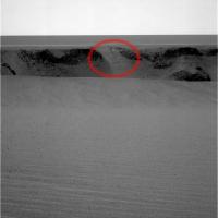
How about something like this? Check out the slope on the right. Granted, we can't see what's below it yet, but that reminds me of the "ramp" that Opportunity used to get in and out of Endurance.
|
|
|
|
|
Sep 27 2006, 09:55 PM
Post
#6
|
|
|
Senior Member Group: Members Posts: 1636 Joined: 9-May 05 From: Lima, Peru Member No.: 385 |
This kind of surface is of outcrop along with a little sand deposition. This slope is okay for Oppy's transversability in going down and also be able in retracting out and its distance would be between 5-10 meters below of rim. Around that there are interesting boulders.
Rodolfo |
|
|
|
|
Sep 27 2006, 10:22 PM
Post
#7
|
|
 Junior Member Group: Members Posts: 71 Joined: 11-May 05 From: Colorado USA Member No.: 386 |
QUOTE (kenny @ Sep 27 2006, 02:27 PM)  There is of course a lot of science to do around the rim and it will be many months before the issue of entering Victoria arises. I notice the one year mission extension just granted is to be spent here at Victoria. Kenny I think we will go in sooner rather than later. There is a growing awareness that the rovers are living on borrowed time. I would bet for early contingency samples below the rim at the "best" location for getting back out -- even if getting back out is considered to be risky. We'd want to do this in an area not far from where we are now, if possible. This is insurance in case we happen to get rover death in the next few months/weeks. S. |
|
|
|
|
Sep 27 2006, 10:32 PM
Post
#8
|
|
|
Founder Group: Chairman Posts: 14432 Joined: 8-February 04 Member No.: 1 |
I think a partial circumnavigation ( even if it includes toe-dipping excursions ) is vital to get as good a view as we can ( from both Pancam AND Mini-TES ) of the whole crater interior.
If we were to drive straight in from where we are now - we'd have no idea what we were driving in to, as we've not seen it in the way we can see the far side now. It is possible and perhaps even likely that the drive into Victoria crater is a one off...each metre driven into the crater might very well be the last chance to study that metre of layering. So it would be madness in my opinion, to not study the crater as fully as possible from the outside, before identifying the best location to study it from the inside. And yes, the rover might die tomorrow - but realistically, I think Opportunity is going to be around for a little while yet - consider the hell that Spirit has and is going through - Opportunity has had it very very easy. Doug |
|
|
|
|
Sep 27 2006, 10:49 PM
Post
#9
|
|
|
Senior Member Group: Members Posts: 2998 Joined: 30-October 04 Member No.: 105 |
I'll agree with Doug. Into Victoria at this point would be a Kamakaze mission with so much to look at up-top. We've been here only a Sol and I've spotted a dozen spots I'd like a closer look at.
--Bill -------------------- |
|
|
|
|
Sep 27 2006, 11:41 PM
Post
#10
|
|
 Senior Member Group: Members Posts: 2173 Joined: 28-December 04 From: Florida, USA Member No.: 132 |
QUOTE (djellison @ Sep 27 2006, 06:32 PM) I think a partial circumnavigation ( even if it includes toe-dipping excursions ) is vital to get as good a view as we can... Remember that the entry into Endurance began as a "toe-dipping excursion". The plan, after testing the footing, was to drive down the stack of exposed layers and then back out. There was no plan to drive across loose material to other parts of the crater when Opportunity first started down. They may well do some toe-dipping without knowing ahead of time which "dip" may turn into a long-term exploration. |
|
|
|
|
Sep 28 2006, 01:22 AM
Post
#11
|
|
|
Junior Member Group: Members Posts: 71 Joined: 11-May 05 From: Colorado USA Member No.: 386 |
There will certainly be an abundance of caution, including imaging of several slopes, and possibly some work on nearby rim-level outcrops, but the main goal at Victoria is to fully investigate deeper layers. Other investigations are secondary. Initial work toward that goal can be done remotely, but within a short time there will be diminishing returns, and you just have to put RAT to rock. A wander around part of the rim, with possible dips below is consistent with what was done successfully at Endurance -- and is the most likely approach to result in good science return. The big question is how bad are the slopes. If they consistently look risky, a longer rim presence is indicated. If we happen to find one that is deemed safe, down we go. That looks fairly unlikely though.
Scott |
|
|
|
|
Sep 28 2006, 01:44 AM
Post
#12
|
|
|
Member Group: Members Posts: 100 Joined: 20-May 06 Member No.: 780 |
As I sometimes need to remind myself, context is (almost) everything. We really need some good views of a number of the cliffs to establish an overall stratiography for Victoria. Given Vicky's size and probable navigational issues, the best views of those cliffs will be from the tops of adjacent capes. We haven't even done that once yet. Without that, toe-dipping and sampling doesn't tell us much of anything about geology and history.
I'm looking forward to getting out on Cabo Frio and taking a long, hard look at Cabo Verde. That's when we really start to learn about Victoria. |
|
|
|
| Guest_Edward Schmitz_* |
Sep 28 2006, 01:48 AM
Post
#13
|
|
Guests |
The views are spectacular, but that's not what the mission is about. Understanding the geology is Opportunity's purpose. The geology is not likely to change from spot to spot along the crater. The best science will be gained by going deeper - not around. It's my opinion that a good entrance should not be passed up.
Having said that... It is starting to look like there might be some very steep angles in some of the layers of some of the outcrops. http://www.unmannedspaceflight.com/index.p...ost&id=7727 Nix posted that in another thread. If it is true that we are seeing angled layers, that would be very interesting to unravel... ed |
|
|
|
|
Sep 28 2006, 04:20 AM
Post
#14
|
|
|
Member Group: Members Posts: 100 Joined: 20-May 06 Member No.: 780 |
Angled layers pretty much mean one of two things, either big chunks have broken off, or something underground is pushing the layers around. There's not much other sign of mountain-building, so we can probably go with the broken rock theory. Besides the question of why the cliffs have collapsed, we need to understand whether the process of collapse has left Victoria in a state that may be risky for foolhardy rovers.
Crater fever is a really bad idea right now. Remember that we did a partial circumnavigation of Endurance before going in. Remember that Endurnace had rocky entrances, which Victoria doesn't seem to have. Remember that Oppy was on borrowed time during just about all of the exploration of Endurance. Victoria really is a different crater from anything we've seen. What's the size of the smallest feature we can see on the far side? What's the effective range of the TES compared to the scale of the views we're seeing? How close can we get to the cliffs from above the rim, versus being down in the sand trying to get up-slope to a cliff? What is the difference in stratiography between the higest point on Victoria's rim, and the lowest? Is there a safe entrance point anywhere on the rim? How do we identify a safe entrance, and does "safe" include the possibility of coming out again? Once we get down into Vicky, how far up-slope will Oppy be able to move? How many of these questions have been answered so far? If we knew that Oppy would die within a week, yeah, going straight in would make sense. But we don't know; it could be a week or six months or a year. It's probably going to be longer rather than shorter, we need a different approach to planning. The ideal would be a long-term plan that provides continuing payoff as we go. That's likely to mean low-risk as long as low risk brings payoff, and keeping options open. To me it doesn't make sense right now to look much beyond our first really close look at the cliffs. That means photography and remote sensing, until we know what we're dealing with on the ramp surfaces. What we learn from both the cliffs and the ramps will determine what comes next. |
|
|
|
|
Sep 28 2006, 04:36 AM
Post
#15
|
|
 Member Group: Members Posts: 809 Joined: 11-March 04 Member No.: 56 |
QUOTE (Edward Schmitz @ Sep 28 2006, 01:48 AM) It is starting to look like there might be some very steep angles in some of the layers of some of the outcrops. Are those sloping layers within one outcrop, or are they sloping faces of cliffs, one in front of the other from this point of view? |
|
|
|
|

|
Lo-Fi Version | Time is now: 23rd May 2024 - 07:57 PM |
|
RULES AND GUIDELINES Please read the Forum Rules and Guidelines before posting. IMAGE COPYRIGHT |
OPINIONS AND MODERATION Opinions expressed on UnmannedSpaceflight.com are those of the individual posters and do not necessarily reflect the opinions of UnmannedSpaceflight.com or The Planetary Society. The all-volunteer UnmannedSpaceflight.com moderation team is wholly independent of The Planetary Society. The Planetary Society has no influence over decisions made by the UnmannedSpaceflight.com moderators. |
SUPPORT THE FORUM Unmannedspaceflight.com is funded by the Planetary Society. Please consider supporting our work and many other projects by donating to the Society or becoming a member. |
|