Bottomless Bay, Next stop after Cape St. Mary |

  |
Bottomless Bay, Next stop after Cape St. Mary |
 Dec 19 2006, 09:44 PM Dec 19 2006, 09:44 PM
Post
#61
|
||
 Member  Group: Members Posts: 239 Joined: 20-April 05 From: Bruxelles, Belgium Member No.: 278 |
I leave my marathon of creation of all spirit's pano for my HiRouteMap to make small pan of sol 1032

-------------------- |
|
 |
 
|
|
|
Dec 19 2006, 11:33 PM
Post
#62
|
|
 Interplanetary Dumpster Diver Group: Admin Posts: 4404 Joined: 17-February 04 From: Powell, TN Member No.: 33 |
Wow...that is one of the most spectacular pans yet. Great work!
-------------------- |
|
|
|
|
Dec 19 2006, 11:48 PM
Post
#63
|
|
|
Member Group: Members Posts: 713 Joined: 30-March 05 Member No.: 223 |
QUOTE (Indian3000 @ Dec 19 2006, 10:44 PM)  I leave my marathon of creation of all spirit's pano for my HiRouteMap to make small pan of sol 1032 congratulations ! very well done ... perfect stitching and impressive atmospheric feel with the extended sky
|
|
|
|
|
Dec 20 2006, 01:22 AM
Post
#64
|
||
 Senior Member Group: Members Posts: 1887 Joined: 20-November 04 From: Iowa Member No.: 110 |
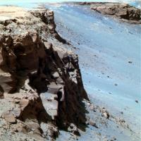
QUOTE (CosmicRocker @ Dec 15 2006, 01:55 AM) That's the same darn blueberry image we argued about earlier. Remember the discussion of cone-shaped berries versus spherical? SS has also used the bathtub ring analogy (I think it is a great analogy) several times previously to describe the concept that the concretions diminished in size and possibly disappeared altogether as Opportunity climbed in elevation, and probably stratigraphically, above an ancient water table. These remind me of a feature in Endurance Crater. Could this be a "bathtub ring"
|
|
|
|
|
|
|
Dec 20 2006, 07:47 AM
Post
#65
|
|
 Senior Member Group: Members Posts: 2228 Joined: 1-December 04 From: Marble Falls, Texas, USA Member No.: 116 |
QUOTE (Indian3000 @ Dec 19 2006, 03:44 PM) I leave my marathon of creation of all spirit's pano for my HiRouteMap to make small pan of sol 1032 Mister Indian3000, that was beautiful. I think you have managed to capture technical perfection and lovely artistic impression in the same grayscale image. I love it. QUOTE (alan @ Dec 19 2006, 07:22 PM) These remind me of a feature in Endurance Crater. Could this be a "bathtub ring" It could well be one appearance of it, but don't think of the BTR as a chiseled line in the rock. If I have the model correctly imagined, it is more like the average highest reach of the the ancient water table. If the groundwater did not dwell for long above a certain level, there will probably not be very many concretions formed there. Probably at the same time the concretions are forming in the ground water saturated environment, other minerals may be dissolving and precipitating elsewhere, creating other changes in the textures of the rock. If the water remains near a level long enough, it can leave an imprint of its presence. But other processes can create an abrupt change such as the one you pointed out. That seems to be a contact worthy of further study.The geochemistry of iron during the formative years of the planets has long been been one of my favorite subjects. That element seems to have been quite abundant on/in the inner planets at the same time certain planets' atmospheres evolved from chemically reducing environments to more oxidizing ones, thus changing the chemical behavior of iron. Seeing such apparently ancient rocks with clues to that story, delivered to us by a space-faring robot created by our species, leaves me speechless... -------------------- ...Tom
I'm not a Space Fan, I'm a Space Exploration Enthusiast. |
|
|
|
|
Dec 21 2006, 12:52 AM
Post
#66
|
|
|
Senior Member Group: Members Posts: 1887 Joined: 20-November 04 From: Iowa Member No.: 110 |
|
|
|
|
|
Dec 21 2006, 03:05 PM
Post
#67
|
|
 Senior Member Group: Moderator Posts: 3431 Joined: 11-August 04 From: USA Member No.: 98 |
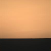
QUOTE (alan @ Dec 21 2006, 12:52 AM) I wondered that too, but it looks like the image is off to the west, about -79 degrees az. I reckon it's just capturing the after-sunset sky glow. |
|
|
|
|
Dec 21 2006, 03:17 PM
Post
#68
|
||
 Senior Member Group: Members Posts: 1619 Joined: 12-February 06 From: Bergerac - FR Member No.: 678 |
So, in color, it gave us that :
-------------------- |
|
|
|
|
|
|
Dec 21 2006, 09:42 PM
Post
#69
|
|
|
Senior Member Group: Moderator Posts: 4279 Joined: 19-April 05 From: .br at .es Member No.: 253 |
FWIW, new pics on the exploratorium after driving on sol 1034.
It looks like a small move, few meters I would guess. Perhaps the rover is positioning itself for a Christmas IDD campaing and/or get some long-baseline info from Bottomless Bay. http://qt.exploratorium.edu/mars/opportuni...cam/2006-12-21/ |
|
|
|
|
Dec 23 2006, 02:45 AM
Post
#70
|
||
|
Senior Member Group: Members Posts: 1887 Joined: 20-November 04 From: Iowa Member No.: 110 |
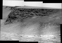
Six image mosaic from sol 1034
|
|
|
|
|
|
|
Dec 23 2006, 05:36 AM
Post
#71
|
||
|
Senior Member Group: Members Posts: 2228 Joined: 1-December 04 From: Marble Falls, Texas, USA Member No.: 116 |
Nice one, alan. I loved the view of the tracks in that direction. The largest block in the ejecta layer on the
Here is the panorama in the drive direction. I think this provides the first good view of one of the north side dark streaks. What do you people think? I can't imagine what else it could be. I wasn't expecting them to have quite as much contrast. I wonder if we'll be able to finally settle the discussions regarding whether they are light dust removal or dark dust deposition features when we get closer views. 
-------------------- ...Tom
I'm not a Space Fan, I'm a Space Exploration Enthusiast. |
|
|
|
|
|
|
Dec 23 2006, 01:37 PM
Post
#72
|
||
|
Member Group: Members Posts: 235 Joined: 2-August 05 Member No.: 451 |
QUOTE (alan @ Dec 22 2006, 09:45 PM) Six image mosaic from sol 1034
This really shows that there is a difference in the amount of dust on the North side faces as opposed to the South side faces. If we only have one shot to pick a place for Opportunity to examine, that's a big clue. |
|
|
|
|
|
|
Dec 23 2006, 04:55 PM
Post
#73
|
|
|
Senior Member Group: Moderator Posts: 3431 Joined: 11-August 04 From: USA Member No.: 98 |
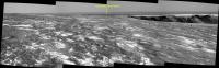
Gotta love those tracks.

|
|
|
|
|
Dec 23 2006, 05:10 PM
Post
#74
|
|
 Member Group: Members Posts: 267 Joined: 5-February 06 Member No.: 675 |
QUOTE (CosmicRocker @ Dec 23 2006, 12:36 AM) ... Here is the panorama in the drive direction. I think this provides the first good view of one of the north side dark streaks. What do you people think? I can't imagine what else it could be. I wasn't expecting them to have quite as much contrast. I wonder if we'll be able to finally settle the discussions regarding whether they are light dust removal or dark dust deposition features when we get closer views. It's interesting that while, according to the drive maps, we crossed over a faint dark streak at the head of Bottomless Bay between Sol 1027 and 1028, there has been no mention of pausing to look at the streak then. If this seems an important question, it suggests that Opportunity will continue her circuit of Victoria at least until she reaches the really dark north streaks (around bay C5 and D2 in the unofficial nomenclature). Steve |
|
|
|
|
Dec 23 2006, 05:19 PM
Post
#75
|
|
|
Member Group: Members Posts: 877 Joined: 7-March 05 From: Switzerland Member No.: 186 |
QUOTE (mhoward @ Dec 23 2006, 05:55 PM) Gotta love those tracks. Yeah very nice composition! And also (gotta lov...) your perfectly stitched mosaics! 
-------------------- |
|
|
|
|

|
Lo-Fi Version | Time is now: 25th May 2024 - 12:35 AM |
|
RULES AND GUIDELINES Please read the Forum Rules and Guidelines before posting. IMAGE COPYRIGHT |
OPINIONS AND MODERATION Opinions expressed on UnmannedSpaceflight.com are those of the individual posters and do not necessarily reflect the opinions of UnmannedSpaceflight.com or The Planetary Society. The all-volunteer UnmannedSpaceflight.com moderation team is wholly independent of The Planetary Society. The Planetary Society has no influence over decisions made by the UnmannedSpaceflight.com moderators. |
SUPPORT THE FORUM Unmannedspaceflight.com is funded by the Planetary Society. Please consider supporting our work and many other projects by donating to the Society or becoming a member. |
|