Opportunity Route Map |

  |
Opportunity Route Map |
 Dec 31 2006, 05:47 PM Dec 31 2006, 05:47 PM
Post
#2041
|
|
 Senior Member  Group: Members Posts: 3419 Joined: 9-February 04 From: Minneapolis, MN, USA Member No.: 15 |
Oh, there is definitely a story out there in terms of cratering rates and how the current erosion rates work on erasing cratering remnants. And I'm sure that somewhere someone is working on it.
However, while we are at a point where we can do *comparative* dating of various geological strata, we just are not and cannot be in a position to do *absolute* dating until and unless we have samples in hand (or we figure out how to do rock dating remotely, on in-situ landers). In fact, for the larger-scale landforms, we already have a comparative dating system (Noachian, Amazonian, etc.). But the actual date ranges in which these land-forming events took place on Mars is still nothing more than energetic arm-waving, at this point. And, again, this will continue to be the case until we can pin down absolute ages in some fashion. -the other Doug -------------------- The trouble ain't that there is too many fools, but that the lightning ain't distributed right. -Mark Twain
|
 |
 
|
|
Dec 31 2006, 07:06 PM
Post
#2042
|
|
 Senior Member Group: Members Posts: 1229 Joined: 24-December 05 From: The blue one in between the yellow and red ones. Member No.: 618 |
Yes, the radio-isotopes will be needed, but it seems to me that there is also a need for some unequivocal way to distinguish between primary and secondary craters. Some of the 'fundamentalist' "crater counters" want to dismiss the latter as few in number (viz. 10% or less) and therefore a minor source of error. But the skeptics seem to prefer higher percentages and bigger errors. Without a way to positively label craters as one or the other (without just saying "Clumped craters are secondary; 'random' craters are primary". This is clearly an oversimplification.), I can't see a way out of this dilemma. One would have to analyze the walls of every crater for meteoritical elements!
 Too hard. Too hard.
-------------------- My Grandpa goes to Mars every day and all I get are these lousy T-shirts!
|
|
|
|
|
Dec 31 2006, 09:26 PM
Post
#2043
|
|
 Senior Member Group: Members Posts: 2488 Joined: 17-April 05 From: Glasgow, Scotland, UK Member No.: 239 |
I suspect that with enough craters counted, and their diameters versus spatial distribution cross-linked, there will emerge a number of patterns from within the chaos. Secondaries, for example, may turn out not to be so randomly distributed - put simply, a chain of craters begs to be considered as something more than mere chance (or an invading comet). Absolute ages on a planet where C-14 testing is removed from the armoury will be difficult; in truth, that particular tool only works on a narrow (recent) band of ages on our own planet.
Arm-waving and hot air; ah, the joys of scientific discourse! Bob Shaw -------------------- Remember: Time Flies like the wind - but Fruit Flies like bananas!
|
|
|
|
|
Dec 31 2006, 10:50 PM
Post
#2044
|
|
|
Member Group: Members Posts: 112 Joined: 17-November 05 From: Canberra Member No.: 558 |
QUOTE (Bob Shaw @ Dec 31 2006, 09:26 PM)  Absolute ages on a planet where C-14 testing is removed from the armoury will be difficult; in truth, that particular tool only works on a narrow (recent) band of ages on our own planet. There are a number of relevant absolute ages (not "dates" please!) pertaining crater count calibration and several ways of obtaining these. the challenge is developing the tools to do this using a rover or , given the limits of power, mass, and number of uinstruments, let alone the fact that the sampled materials at the site might not cover a wide age range. First is the formation age of the rock. The two most likely ways are K-Ar, Ar-Ar, and Rob-Sr. Whole rock mass spectroscopy would determine the Ar ratios, and XRF will determine the abount of K, Sr, and Rb. Measurement of the gamma wavelength, alpha, and beta energy spectrum will determine the amount of the relevant non-volatile radioactive isotope present. from this an approximate whole rock Then the exposure age of the rock, the time the rock has spent within ~1 m of the surface. This can be done using cosmogenic isotopes. As before, a combination of Whole rock mass spectroscopy (for volatile elements), XRF (for non volatile elments), and radioactivity spectroscopy would enablewould determine the Ar ratios, and XRF will determine the abount of K, Sr, and Rb. Measurement of the gamma wavelengths, alpha, and beta energy spectrum will determine the amount of the relevant radioactive isotope present. You would also need to measure the in situ and free air cosmic ray level. These methods need only feasible improvements on instruments already flown (or even isting ones, Beagle 2 had, as I recall, the capability for whole rock dating). Further, the instruments supply other data (whole rock analyses, sbale isotopic data, radiation environment. They could be part of any future rover or lander package. They won't be highly accurate, probably at best 10%, but that will still be an improvement over crater counts. Anyone have an idea of how many areas will need age determinations to adequately constrain the crater counts? Two, five" More? Detailed geochronological studies will need sample return. Jon |
|
|
|
|
Jan 1 2007, 01:46 AM
Post
#2045
|
|
|
Senior Member Group: Members Posts: 1229 Joined: 24-December 05 From: The blue one in between the yellow and red ones. Member No.: 618 |
QUOTE (JonClarke @ Dec 31 2006, 12:50 PM) Anyone have an idea of how many areas will need age determinations to adequately constrain the crater counts? Two, five" More? Detailed geochronological studies will need sample return. Jon Pick a number, Jon, but the bigger the better! I fear that if someone wants to pile uncertainty on the whole notion of crater counting, there are a number of variables one can invoke to "monkeywrench" the works. E.g. How target rock strength affects size of craters and the rate at which they disappear due to erosion and/or burial. Similarly, how geography affects wind strengths and/or temperature fluctuations and hence erosion rates. What is the effect of crater exhumation? Oh me, oh my! A dedicated skeptic could drag this out ad nauseam. "Detailed geochronological studies" of Earth rocks are already the source of endless debate. These days you have to examine and hand-pick individual zircons under the microscope, and even then somebody will complain that some of them had undergone some "recrystallization" and should have been excluded. I swear, it's a wonder people keep on trying. 
-------------------- My Grandpa goes to Mars every day and all I get are these lousy T-shirts!
|
|
|
|
|
Jan 1 2007, 03:54 AM
Post
#2046
|
|
|
Member Group: Members Posts: 112 Joined: 17-November 05 From: Canberra Member No.: 558 |
QUOTE (Shaka @ Jan 1 2007, 01:46 AM) Pick a number, Jon, but the bigger the better! I fear that if someone wants to pile uncertainty on the whole notion of crater counting, there are a number of variables one can invoke to "monkeywrench" the works. E.g. How target rock strength affects size of craters and the rate at which they disappear due to erosion and/or burial. Similarly, how geography affects wind strengths and/or temperature fluctuations and hence erosion rates. What is the effect of crater exhumation? Oh me, oh my! A dedicated skeptic could drag this out ad nauseam. "Detailed geochronological studies" of Earth rocks are already the source of endless debate. These days you have to examine and hand-pick individual zircons under the microscope, and even then somebody will complain that some of them had undergone some "recrystallization" and should have been excluded. I swear, it's a wonder people keep on trying. This can be said of all research. The more you learn the more questions there are. The nature of the debate varies as well. Generally it is only key or controversial ages that are generally debated. Otherwise what is generally done is refining of existing ages. On Mars I suggest at least 3 measurements to at least crudely constrain the ages and give meaning to the epochs. Six would allow refinement of the subdivisions within them and constrain the mineralogical evolution suggested by OMEGA data. Jon |
|
|
|
|
Jan 1 2007, 08:07 PM
Post
#2047
|
|
 Senior Member Group: Members Posts: 4247 Joined: 17-January 05 Member No.: 152 |
A new feature name or two from the latest Planetary Society update:
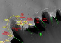
QUOTE With that work finished, Opportunity heads to the next location, "directly east from its location to the edge of the next major alcove," clockwise from Bottomless Bay, Squyres said. "We'll be imaging the promontory directly across from there, which is very sharp, very pronounced promontory that we've named Cape Desire. We're hoping by New Year's we'll be over at that next alcove, which we've called the Bay of Toil." I make Cape Desire to be our Cape B3, and the Bay of Toil our Bay B3. |
|
|
|
|
Jan 1 2007, 09:38 PM
Post
#2048
|
|
|
Senior Member Group: Moderator Posts: 4279 Joined: 19-April 05 From: .br at .es Member No.: 253 |
Actually, I already updated my route map to include those names.
Just one clarification: I assume "Bay B3" is that one between capes B2 and B3, right? |
|
|
|
|
Jan 1 2007, 09:52 PM
Post
#2049
|
|
|
Senior Member Group: Members Posts: 4247 Joined: 17-January 05 Member No.: 152 |
That's right, the bays take the name of the cape that's clockwise of the bay, according to our scheme.
|
|
|
|
|
Jan 3 2007, 12:39 PM
Post
#2050
|
|
 Special Cookie Group: Members Posts: 2168 Joined: 6-April 05 From: Sintra | Portugal Member No.: 228 |
Tesheiner...
More work for you...  EDITED: Where on Earth is this Bay of Toil and Cape Desire?!... Can't find them anywhere... EDITED AGAIN: I think I found Cape Desire... But the original name isn't of a Cape, is a Port, Puerto Deseado, or in English Port Desire... AND EDITED ONCE MORE: Here's the Bay of Toil, on chapter 5... And a great read that is! I remember SS telling me that the author was the one generating the list of places to name features in Victoria. -------------------- "Ride, boldly ride," The shade replied, "If you seek for Eldorado!"
Edgar Alan Poe |
|
|
|
|
Jan 3 2007, 01:49 PM
Post
#2051
|
||
|
Senior Member Group: Moderator Posts: 4279 Joined: 19-April 05 From: .br at .es Member No.: 253 |
Here are them. I had those places already updated on the map just waiting for the next move by Opportunity.
|
|
|
|
|
|
|
Jan 3 2007, 02:06 PM
Post
#2052
|
|
 Junior Member Group: Members Posts: 29 Joined: 6-April 06 From: Finland > Turku Member No.: 733 |
Why rover goes to there?
duck bay and bottomless bay are only ways to Victoria?, I think |
|
|
|
|
Jan 3 2007, 02:34 PM
Post
#2053
|
|
|
Senior Member Group: Moderator Posts: 4279 Joined: 19-April 05 From: .br at .es Member No.: 253 |
> Why rover goes to there?
Because the search for an entry point is just one of the reasons for this circumnavigation, and probably not the highest priority one.  Analyze the morphology and mineralogy of the terrain and the crater walls is a priority too. |
|
|
|
|
Jan 3 2007, 04:24 PM
Post
#2054
|
|
|
Member Group: Members Posts: 240 Joined: 18-July 06 Member No.: 981 |
And SS has mentioned the stuff which most interests him is 120 degrees clockwise from Duck Bay. They'll want to have a good look at that first before descending.
|
|
|
|
|
Jan 3 2007, 05:40 PM
Post
#2055
|
|
|
Member Group: Members Posts: 910 Joined: 4-September 06 From: Boston Member No.: 1102 |
Any idea what stuff that is?
-------------------- |
|
|
|
|

|
Lo-Fi Version | Time is now: 23rd May 2024 - 04:59 PM |
|
RULES AND GUIDELINES Please read the Forum Rules and Guidelines before posting. IMAGE COPYRIGHT |
OPINIONS AND MODERATION Opinions expressed on UnmannedSpaceflight.com are those of the individual posters and do not necessarily reflect the opinions of UnmannedSpaceflight.com or The Planetary Society. The all-volunteer UnmannedSpaceflight.com moderation team is wholly independent of The Planetary Society. The Planetary Society has no influence over decisions made by the UnmannedSpaceflight.com moderators. |
SUPPORT THE FORUM Unmannedspaceflight.com is funded by the Planetary Society. Please consider supporting our work and many other projects by donating to the Society or becoming a member. |
|