Opportunity Route Map |

  |
Opportunity Route Map |
 Mar 27 2007, 03:48 AM Mar 27 2007, 03:48 AM
Post
#2161
|
|
 Senior Member  Group: Members Posts: 1887 Joined: 20-November 04 From: Iowa Member No.: 110 |
Cool, Oppy is now past Victoria's northernmost point.
|
 |
 
|
|
Mar 27 2007, 09:47 AM
Post
#2162
|
||
|
Senior Member Group: Moderator Posts: 4279 Joined: 19-April 05 From: .br at .es Member No.: 253 |
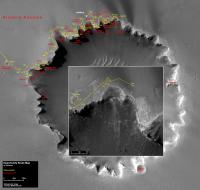
Updated route map (sol 1127).
|
|
|
|
|
|
|
Mar 29 2007, 11:00 AM
Post
#2163
|
||
|
Senior Member Group: Moderator Posts: 4279 Joined: 19-April 05 From: .br at .es Member No.: 253 |
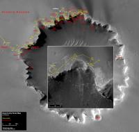
Updated route map (sol 1129).

|
|
|
|
|
|
|
Mar 30 2007, 10:57 AM
Post
#2164
|
||
|
Senior Member Group: Moderator Posts: 4279 Joined: 19-April 05 From: .br at .es Member No.: 253 |
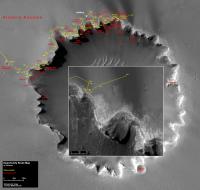
Updated route map (sol 1130).
|
|
|
|
|
|
|
Apr 1 2007, 01:55 PM
Post
#2165
|
||
|
Senior Member Group: Moderator Posts: 4279 Joined: 19-April 05 From: .br at .es Member No.: 253 |
Updated route map (sol 1132).
|
|
|
|
|
|
|
Apr 1 2007, 09:43 PM
Post
#2166
|
|
|
Member Group: Members Posts: 235 Joined: 2-August 05 Member No.: 451 |
I guess Tierra del Fuego is the end of the line for the trip around the crater. I'm looking just beyond there and I see two places where the dark-light pattern in the sand looks like the pattern familiar to me as rivers in larger images. I'm not saying there's any reason to think water was involved, but I'm curious to hear ideas about what formed them, and perhaps get a closer look. Are these the only places near Victoria where this sort of pattern occurs?
|
|
|
|
|
Apr 2 2007, 02:48 PM
Post
#2167
|
|
 Senior Member Group: Members Posts: 2173 Joined: 28-December 04 From: Florida, USA Member No.: 132 |
QUOTE (antoniseb @ Apr 1 2007, 05:43 PM)  I guess Tierra del Fuego is the end of the line for the trip around the crater. What happened to checking out the fractures over by "Soup Dragon" to see if there was any water-born mineral deposits in them? Not that I'm unhappy about making a beeline for Duck Bay and a closeup look at the base of a prominence. |
|
|
|
|
Apr 3 2007, 04:14 PM
Post
#2168
|
||
|
Senior Member Group: Moderator Posts: 4279 Joined: 19-April 05 From: .br at .es Member No.: 253 |
Updated route map (sol 1134).
|
|
|
|
|
|
|
Apr 3 2007, 05:09 PM
Post
#2169
|
|
|
Member Group: Members Posts: 252 Joined: 5-May 05 From: Mississippi (USA) Member No.: 379 |
QUOTE (centsworth_II @ Apr 2 2007, 10:48 AM) What happened to checking out the fractures over by "Soup Dragon" to see if there was any water-born mineral deposits in them? I can't answer your question, but don't feel lonely. The same question is also in my mind. Jack
|
|
|
|
|
Apr 6 2007, 07:56 PM
Post
#2170
|
||
|
Senior Member Group: Moderator Posts: 4279 Joined: 19-April 05 From: .br at .es Member No.: 253 |
Another map update (sol 1137) including a shift to the zoom picture.
Last drive into the "darkness" went way out of the previous zoom.
|
|
|
|
|
|
|
Apr 11 2007, 08:15 PM
Post
#2171
|
|
|
Member Group: Members Posts: 258 Joined: 22-December 06 Member No.: 1503 |
It's now Sol 1142 for Oppy. The latest Navcams and Pancams are down. It appears to me that Oppy has moved substantially--in an unexpected direction, according to plans reported in the updates from the Planetary Society. The MER team may have decided to investigate the NE section of bays of Victoria. At least they are taking images of that area from a spot that appears closer than before.
|
|
|
|
|
Apr 11 2007, 08:18 PM
Post
#2172
|
|
|
Founder Group: Chairman Posts: 14432 Joined: 8-February 04 Member No.: 1 |
Actually - it ties in well with the visit a dark trail then visit the source of a dark trail plan.
Doug |
|
|
|
|
Apr 11 2007, 08:48 PM
Post
#2173
|
|
|
Member Group: Members Posts: 258 Joined: 22-December 06 Member No.: 1503 |
Yes, it does make sense. But their recent statements suggested they would quickly take a look at Tierra del Fuego, then high tail it back to Valley Without Peril for a possible toe dip--then retrace back to Duck Bay for the real ingress. It now appears the investigation of Tierra del Fuego is going to take a lot longer than expected. It might also lead to a closer investigation of the bays on the NE side of Victoria, like what most of us thought would happen very early on because of what Steve said in interviews. I think they have an eye on those pipes as a possible source of the dark deposits.
|
|
|
|
|
Apr 11 2007, 09:07 PM
Post
#2174
|
|
 Senior Member Group: Members Posts: 1229 Joined: 24-December 05 From: The blue one in between the yellow and red ones. Member No.: 618 |
 OOOHh! Tres tres kewl! JPL has a new 'official route map' with isometric lines at 2-meter intervals:NEW MAP OOOHh! Tres tres kewl! JPL has a new 'official route map' with isometric lines at 2-meter intervals:NEW MAPQuick, who's going to be first to calculate the slopes of all the bays?  fun, fun, fun fun, fun, fun  P.S. Please add a horizontal scale bar, Mister NASA! Pretty please! -------------------- My Grandpa goes to Mars every day and all I get are these lousy T-shirts!
|
|
|
|
|
Apr 11 2007, 09:07 PM
Post
#2175
|
|
|
Founder Group: Chairman Posts: 14432 Joined: 8-February 04 Member No.: 1 |
And you guessing all of this from a single drive toward a target we already knew they were driving to?
To date, they are following the plan as mentioned on planetary.org to the letter. They've driven into a dark streak, and this recent drive ( from which you are reading an array of things none of which are related to the drive itself ) is exactly what the next step should be - driving back up the streak toward where it meets the crater. Then, Tierra Del Fuego (to get the views of the next bay/cape along, and back toward VWOP - then VWOP for a possible toe dip, then back to Duck Bay. The stuff here should take about a fortnight. I'm not quite sure what you thought the plan was, and why you think what's going on is not the plan...but it is. Doug |
|
|
|
|

|
Lo-Fi Version | Time is now: 29th May 2024 - 12:55 PM |
|
RULES AND GUIDELINES Please read the Forum Rules and Guidelines before posting. IMAGE COPYRIGHT |
OPINIONS AND MODERATION Opinions expressed on UnmannedSpaceflight.com are those of the individual posters and do not necessarily reflect the opinions of UnmannedSpaceflight.com or The Planetary Society. The all-volunteer UnmannedSpaceflight.com moderation team is wholly independent of The Planetary Society. The Planetary Society has no influence over decisions made by the UnmannedSpaceflight.com moderators. |
SUPPORT THE FORUM Unmannedspaceflight.com is funded by the Planetary Society. Please consider supporting our work and many other projects by donating to the Society or becoming a member. |
|