New Iapetian image series |

 Unmanned Spaceflight.com > Outer Solar System > Saturn > Cassini Huygens > Cassini's ongoing mission and raw images
  |
New Iapetian image series |
 Jul 9 2007, 09:19 PM Jul 9 2007, 09:19 PM
Post
#121
|
|
|
Solar System Cartographer  Group: Members Posts: 10153 Joined: 5-April 05 From: Canada Member No.: 227 |
I'm fairly confident there is no double rim, and the problem is in the reprojection, perhaps spread over both sides of the gap. The apparent crater on the east rim of the new basin fits nicely in a shadow space in the old image if things are shifted a bit.
Phil -------------------- ... because the Solar System ain't gonna map itself.
Also to be found posting similar content on https://mastodon.social/@PhilStooke Maps for download (free PD: https://upload.wikimedia.org/wikipedia/comm...Cartography.pdf NOTE: everything created by me which I post on UMSF is considered to be in the public domain (NOT CC, public domain) |
 |
 
|
|
Jul 9 2007, 11:26 PM
Post
#122
|
|
 Senior Member Group: Members Posts: 1630 Joined: 5-March 05 From: Boulder, CO Member No.: 184 |
I'll be interested to see whether things will shift enough to fully account for the offset I'm now seeing. Here are two more links. The first image is a new preliminary map with all the old and new images added. The second is the ISS map that I'm using for comparison. There are some differences though I've yet to see enough of an obvious difference that would fill the gap.
http://laps.noaa.gov/albers/sos/saturn/iap...gb_cyl.1-29.jpg http://laps.noaa.gov/albers/sos/saturn/iap...etus_ssi_1k.jpg One more reason to wait until September 
-------------------- Steve [ my home page and planetary maps page ]
|
|
|
|
|
Jul 10 2007, 03:46 AM
Post
#123
|
|
 Lord Of The Uranian Rings Group: Members Posts: 798 Joined: 18-July 05 From: Plymouth, UK Member No.: 437 |
Steve,
Could your problems be caused by the fact that Iapteus isn't perfectly spherical? I imagine that might cause some significant distortions in your image reprojections. Ian. -------------------- |
|
|
|
|
Jul 10 2007, 08:18 PM
Post
#124
|
|
|
Senior Member Group: Members Posts: 1630 Joined: 5-March 05 From: Boulder, CO Member No.: 184 |
Ian,
That is a possibility to consider. This might be kind of in mid-stream, as for some of the key images I've switched from a spherical assumption to using a triaxial ellipsoid that has been recently published. Hopefully my software is doing that with enough accuracy. However much of the projection error associated with assuming a perfect sphere ends up being in the north-south direction, at least for images with a sub-spacecraft point near the equator. Most of the offset I'm seeing with the basin is in the east-west direction. The older image with the shadowed version of the basin (Oct 2004) was projected assuming a sphere, so I am thinking of redoing that one. This was released from CICLOPS with a grid overlay so I was assuming things were fairly accurately done. Another thing is that I see the Voyager image may also need to be switched over to a triaxial ellipsoid and that is a key connecting image. Perhaps this being a polar view will show more of a shift? -------------------- Steve [ my home page and planetary maps page ]
|
|
|
|
|
Jul 11 2007, 12:18 AM
Post
#125
|
||
|
Member Group: Members Posts: 509 Joined: 2-July 05 From: Calgary, Alberta Member No.: 426 |
QUOTE (scalbers @ Jul 10 2007, 02:18 PM)  This might be kind of in mid-stream, as for some of the key images I've switched from a spherical assumption to using a triaxial ellipsoid that has been recently published. Hopefully my software is doing that with enough accuracy. However much of the projection error associated with assuming a perfect sphere ends up being in the north-south direction, at least for images with a sub-spacecraft point near the equator. Most of the offset I'm seeing with the basin is in the east-west direction. Ooooh... trusting that triaxial ellipsoid could be part of your problem. Take a look at this image from 2004:
The part of Iapetus that appears on the western limb in the above image is in roughly the same part of the moon as the eastern limb from the images of Roncevaux Terra that came down the pipeline the other day. Look at the sharp "zenith discontinuity" at the equator. A triaxial ellipsoid can't possibly model that properly. The traxial ellipsoid is probably some sort of best-fit that likely deviates substantially from the true surface in a lot of places. I don't doubt that it's the best we've got, but it won't be anywhere near perfect. Just eyeballing the new Roncevaux Terra images, it looks as if the true limb is "squashed inwards" near the basin. The triaxial ellipsoid probably lies outside the true surface in this part of Iapetus. This would cause anything lying close to the true limb to appear to be closer to Cassini than it actually is. |
|
|
|
|
|
|
Jul 11 2007, 05:56 PM
Post
#126
|
|
 Member Group: Members Posts: 288 Joined: 28-September 05 From: Orion arm Member No.: 516 |
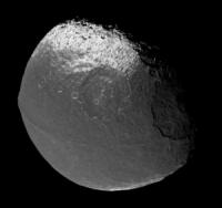
Hi,
there's another single Iapetus pic available now: 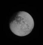 Date: most likely today Distance: ? Maybe someone can pump more information out of it ? Bye. |
|
|
|
|
Jul 11 2007, 06:32 PM
Post
#127
|
|
|
Senior Member Group: Members Posts: 1630 Joined: 5-March 05 From: Boulder, CO Member No.: 184 |
Rob's image in post #125 is a good one to consider also. I redid my fit using the triaxial ellipsoid and allowing for a little scrunching just south of the bellyband on the western side. You can see my fit at this URL:
http://laps.noaa.gov/albers/sos/saturn/iap...o13_gridded.jpg The western limb of this image is still quite a distance away from the Ronceveaux Terra basin. My new fit agrees pretty closely with the older one though I have an offset in both a few degrees to the NW of the ISS map. So every correction that can be made will help though there's still quite some ways to go before I can make the RT basin inconsistency go away. I think that my map agrees with the ISS map (post #122) reasonably well for the Snowman craters and with the gridded ISS image for the Voyager mountains. Perhaps one of them may have to move significantly to really close the basin gap. The Voyager mountain agreement is illustrated at this URL: http://laps.noaa.gov/albers/sos/saturn/iap...o11_gridded.jpg In the middle pair of images the lower one is the ISS fit and the upper one is my (still spherical) fit. I just saw TA's new image so I'll think about that one as well. I see on the raw images page that there's no date or distance info so I wonder if the central longitude has shifted since the July 8 images? -------------------- Steve [ my home page and planetary maps page ]
|
|
|
|
|
Jul 11 2007, 07:47 PM
Post
#128
|
|
 Senior Member Group: Moderator Posts: 3233 Joined: 11-February 04 From: Tucson, AZ Member No.: 23 |
Regardless, it is always best to use the triaxial ellipsoid radii than assuming a spherical body, particularly for Iapetus! However, keep in mind that the region we are looking at now has been pretty poorly mapped before and the DLR map may not be a good fit, yet. Hopefully, after September's flyby, we will have some better results on the control point network and the triaxial ellipsoid shape.
-------------------- &@^^!% Jim! I'm a geologist, not a physicist!
The Gish Bar Times - A Blog all about Jupiter's Moon Io |
|
|
|
|
Jul 11 2007, 09:06 PM
Post
#129
|
|
 Senior Member Group: Members Posts: 2530 Joined: 20-April 05 Member No.: 321 |
Could another component of the "basin gap" be that a broad basin rim shows up as shading on the eastern slopes of the (broad) rim in some lighting and as shading on the western slopes in opposite lighting?
http://www.phys.ncku.edu.tw/~astrolab/mirr...Orbiter4_c1.jpg With Mare Orientale on the Moon, for example, lighting from the east will show the eastern rim mainly as a shadow to the west of the highest level. Lighting from the west will show a shadow to the east of the highest level. This could amount to some 50-100 km perhaps if a basin's rims were really broad. |
|
|
|
|
Jul 12 2007, 02:09 PM
Post
#130
|
|
|
Member Group: Members Posts: 288 Joined: 28-September 05 From: Orion arm Member No.: 516 |
QUOTE (TritonAntares @ Jul 11 2007, 07:56 PM) Date: 2007-07-09Distance: 2,846,206 km Filters: CL1 and CL2 
|
|
|
|
|
Jul 12 2007, 03:25 PM
Post
#131
|
|
|
Member Group: Members Posts: 509 Joined: 2-July 05 From: Calgary, Alberta Member No.: 426 |
QUOTE (JRehling @ Jul 11 2007, 03:06 PM) Could another component of the "basin gap" be that a broad basin rim shows up as shading on the eastern slopes of the (broad) rim in some lighting and as shading on the western slopes in opposite lighting? That's a really interesting point, but I don't think it will work in this particular instance. In these images, the basin is pretty close to the longitude of the sub-solar point, so there shouldn't be any shadows at all on the eastern and western slopes. (Mind you, as Steve noted in his previous post, my idea of "pretty close" seems to be about 45 degrees larger than the definition most people would use.  ) )There *could* be some apparent north-south displacement, of course. And to reply to Jason: No doubt the triaxial ellipsoid approximation will be *way* better than the spherical approximation. I'm just saying that it's still not really all that great. However, I could believe that *separate* triaxial ellipsoids, fitted to the northern and southern hemispheres, could do a much better job. Somebody must have tried this by now. The other thing would be a spherical harmonic approximation out to about 473 terms. This will inevitably turn into someone's senior-year, or master's, thesis project. (I pity the poor kid who gets it. Harbouring intense bitterness towards a ball of ice a billion kilometres away would be difficult to explain to other students at the campus pub. In particular, it could really turn off the girls in English and Philosophy.) |
|
|
|
|
Jul 12 2007, 05:48 PM
Post
#132
|
|
|
Senior Member Group: Members Posts: 1630 Joined: 5-March 05 From: Boulder, CO Member No.: 184 |
QUOTE (TritonAntares @ Jul 12 2007, 02:09 PM) Date: 2007-07-09 Distance: 2,846,206 km Filters: CL1 and CL2 2x enlarged Thanks for the info T-A. I'm afraid though we only get a half degree eastward shift in longitude so that would be a limited amount of additional information EDITs (last at 1800 UTC July 14) : By the way, looking at the Voyager image refitted with the triaxial ellipsoid showed some modest shifts mainly at higher northern latitudes. I see some issues now with the fit of this image with others in high northern latitudes at around 220 E longitude. In any event, a closer look at the Voyager image along equatorial latitudes suggests to me the "basin gap" may even be slightly larger than I've mapped previously. I'm assuming for example that I can correctly identify the crater Hamon in the July 8 images. The Voyager image alone can reasonably tie in the July 8 imagery to the Oct 2004 images and make a case for the basin gap. I've also now refitted the Oct 2004 images (including the shadowed basin one) to the triaxial ellipsoid. These had some interesting shifts in the more southerly latitudes. The basin does seem from the July 8 imagery to be rather large, so perhaps it could have some sort of extra rings or shadows on the east side that show up in the Oct 2004 lighting as JRehling suggests? I could still see the possibility of some sort of smaller (perhaps older and partly covered) secondary basin to the east. Here's the latest version based on various recent refits: http://laps.noaa.gov/albers/sos/saturn/iap..._cyl.070712.jpg -------------------- Steve [ my home page and planetary maps page ]
|
|
|
|
|
Jul 15 2007, 09:24 AM
Post
#133
|
|
|
Member Group: Members Posts: 288 Joined: 28-September 05 From: Orion arm Member No.: 516 |
So,
yet another single Iapetus pic is online: 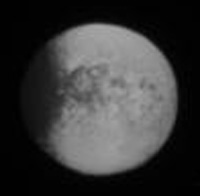 Date: most likely yesterday Distance: ? 2x enlarged Maybe someone can pump more information out of the original ? Bye. |
|
|
|
|
Jul 15 2007, 10:16 AM
Post
#134
|
|||
|
Member Group: Members Posts: 288 Joined: 28-September 05 From: Orion arm Member No.: 516 |
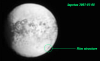
Looking through all the images of this far encounter I took notice of a dark structure at the eastern rim of the new bright basin in southern Roncevaux Terra:
Could this be another landslide? There seems to be a bright semicircular zone surrounding the dark structure inbound the basin. Some answers may be hidden in these two images:
The possibilty of a second over-/underlying smaller impact structure - as some of you speculated - is very unlikely, I suppose. Bye. |
||
|
|
|
||
|
Jul 15 2007, 01:30 PM
Post
#135
|
|
|
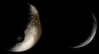
Senior Member Group: Members Posts: 1630 Joined: 5-March 05 From: Boulder, CO Member No.: 184 |
Interesting to look in more detail at structures on the eastern side of the basin. Was it Ian who earlier composed the stacked image for July 8? This appears to show some of the features better than the single image I used in my test map. Would it be OK if I were to try using your stacked image instead to see if it shows things better?
The crescent image is one I've yet to use much in mapping, this might be interesting to give a try and see how it fits in. It might be easier in some ways to wait until September to see how the basin images fit, yet I'll indulge a bit more in my wild speculation about the potential basin gap that I see. Following up on my mention of the crater Hamon, I will check again how it fits between the Voyager image and the July 8 views. Then using the Voyager image to fit features to the Oct 2004 imagery for the Voyager mountains and environs I think one can come up with a reasonable solution for the location of the basin (or dare I suggest basins ).Going one tentative step further, my experimental map I think had the location of the rim feature T/A is circling to coincide with the apparent "central peaks" in the Oct 2004 imagery... -------------------- Steve [ my home page and planetary maps page ]
|
|
|
|
|

|
Lo-Fi Version | Time is now: 29th April 2024 - 11:50 AM |
|
RULES AND GUIDELINES Please read the Forum Rules and Guidelines before posting. IMAGE COPYRIGHT |
OPINIONS AND MODERATION Opinions expressed on UnmannedSpaceflight.com are those of the individual posters and do not necessarily reflect the opinions of UnmannedSpaceflight.com or The Planetary Society. The all-volunteer UnmannedSpaceflight.com moderation team is wholly independent of The Planetary Society. The Planetary Society has no influence over decisions made by the UnmannedSpaceflight.com moderators. |
SUPPORT THE FORUM Unmannedspaceflight.com is funded by the Planetary Society. Please consider supporting our work and many other projects by donating to the Society or becoming a member. |
|