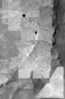
Spirit Route Map, Small and Large Scales |

  |
Spirit Route Map, Small and Large Scales |
 Jul 16 2007, 02:30 PM Jul 16 2007, 02:30 PM
Post
#556
|
|
 Senior Member  Group: Members Posts: 2173 Joined: 28-December 04 From: Florida, USA Member No.: 132 |
Maybe they figure if Spirit is not going anywhere for
awhile, it might as well be parked at an interesting spot. |
 |
 
|
|
Jul 17 2007, 04:58 AM
Post
#557
|
|
|
Senior Member Group: Members Posts: 1870 Joined: 20-February 05 Member No.: 174 |
Maybe it would be good to give different overlapping route-segments and sol-numbers differrent colors in sequence.. oldest blue, green yellow, red as youngest, maybe more intermediate colors.
This map is turning into a spaghetti trace! |
|
|
|
|
Jul 17 2007, 06:57 AM
Post
#558
|
|
|
Member Group: Members Posts: 258 Joined: 22-December 06 Member No.: 1503 |
QUOTE (edstrick @ Jul 16 2007, 11:58 PM)  Maybe it would be good to give different overlapping route-segments and sol-numbers differrent colors in sequence.. oldest blue, green yellow, red as youngest, maybe more intermediate colors. This map is turning into a spaghetti trace! I agree that it is becoming a 'cluster'; however, different colors won't help at all. What we need is something that may not be practical or at least expected--we need overlays that can be removed. It doesn't matter what color the route is; the lines and numbers obscure the terrain. It is difficult to follow where the MER team's interests are on the map. If less stuff was on the map, then objects of interest might be easier to see or at least imagine. It would also help to be able to add parts of the route as needed. That's why I suggest some sort of overlay system. However, that won't be easy to do well. And I would not ask anybody to do it just for my convenience. |
|
|
|
|
Jul 17 2007, 09:07 AM
Post
#559
|
|
|
Senior Member Group: Moderator Posts: 4279 Joined: 19-April 05 From: .br at .es Member No.: 253 |
I agree that colors won't help much; the clutter would still be there.
And about the overlays, the map in it's original format (PhotoShop-like) has a good number of layers. The problem is that those files are *big* (latest map is 4MB) and I want to keep the attachments here on this thread below my self-imposed limit of 512kB. For the time being I will keep it as it is. My hope was (and still is) that Spirit would leave this area and move on to new places. QUOTE (edstrick @ Jul 17 2007, 06:58 AM) This map is turning into a spaghetti trace! Like my prediction for sol 1521: http://www.unmannedspaceflight.com/index.p...ost&p=92053 |
|
|
|
|
Jul 17 2007, 09:46 AM
Post
#560
|
||
|
Founder Group: Chairman Posts: 14432 Joined: 8-February 04 Member No.: 1 |
Colours, layers etc etc - it's all still rammed into a 25cm/pixel image. We need soething better. I think what we need is a map of Silica Valley based on Vert-Proj Navcam imagery
http://pds-imaging.jpl.nasa.gov/data/mer2-...avcam/site0125/ It's not great - they ran through there fairly fast on the way to Tyrone/LRH - but I think it might help improve things a little. I've done a very very quick, bad, dirty stitch of all the VP's I can find in that run through - and reprojected to 5cm/pixel ( i.e. HiRISE of 25cm @ 500% - VP's of 1cm at 20% ) There are four places where I think something like this is worth trying. Eagle Crater, Endurance Crater ( SW quadrant of ) at MP, and for Spirit, the Larrys Lookout-Methuselah area, and Silica Valley to LRH.
Attached thumbnail(s)
|
|
|
|
|
|
|
Jul 17 2007, 10:25 AM
Post
#561
|
|
|
Senior Member Group: Moderator Posts: 4279 Joined: 19-April 05 From: .br at .es Member No.: 253 |
QUOTE (djellison @ Jul 17 2007, 11:46 AM) Colours, layers etc etc - it's all still rammed into a 25cm/pixel image. 10cm/pix.  It's actually a 5x zoom compared with my previous version of route map (using a MOC image). When I did that change I thought it would be more then enough, but... |
|
|
|
|
Jul 17 2007, 02:02 PM
Post
#562
|
|
|
Founder Group: Chairman Posts: 14432 Joined: 8-February 04 Member No.: 1 |
This could work better with terrain meshes, textures, then re-rendered from above...but that's a LOT of work
 Doug |
|
|
|
|
Jul 17 2007, 03:46 PM
Post
#563
|
|
 Senior Member Group: Members Posts: 4246 Joined: 17-January 05 Member No.: 152 |
As far as the map getting more and more cluttered and not being able to see the terrain underneath, here's my suggestion. Find an older version of Tesheiner's map in this thread, say from a hundred or more sols ago. Open both the old and new maps. Then just flip from one to the other. The maps have covered the exact same area for a long time, so this is just like having an overlay or layer of rover tracks that you can toggle on and off.
I think the current "fading old tracks" system is probably about the best we can do given Spirit's current predicament mired in Silica valley. (I know, lot's of science here!) |
|
|
|
| Guest_Oersted_* |
Jul 17 2007, 04:18 PM
Post
#564
|
|
Guests |
I think a zoomed-in area will do together with maybe small shadows on earlier tracks by overlaid later tracks. A slight shadow will really help make it obvious which track overlays which other track.
|
|
|
|
|
Aug 25 2007, 07:24 AM
Post
#565
|
||
|
Senior Member Group: Moderator Posts: 4279 Joined: 19-April 05 From: .br at .es Member No.: 253 |
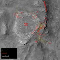
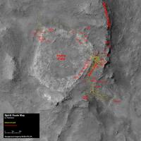
Spirit should be finally (?) leaving Silica Valley.
http://marsrovers.jpl.nasa.gov/mission/sta...ll.html#sol1288 QUOTE Spirit "drove" 42 centimeters (16 ½ inches) to a new position. Weekend plans called for the first multi-meter drive toward the elevated plateau known as "Home Plate" My updated route map for sol 1293.
|
|
|
|
|
|
|
Aug 29 2007, 07:40 AM
Post
#566
|
||
|
Senior Member Group: Moderator Posts: 4279 Joined: 19-April 05 From: .br at .es Member No.: 253 |
Yet another update, now after driving on sol 1298.
This area around Silica Valley was so cluttered in the map that I decided to remove all these tiny movements and substitute them by a single fuzzy dot. If anybody wants to see all the moves backwards and forwards just keep a copy of the map for sol 1293 on the previous post.
|
|
|
|
|
|
|
Aug 31 2007, 07:41 AM
Post
#567
|
||
|
Senior Member Group: Moderator Posts: 4279 Joined: 19-April 05 From: .br at .es Member No.: 253 |
Spirit route map, updated to sol 1300.
|
|
|
|
|
|
|
Sep 4 2007, 08:05 AM
Post
#568
|
||
|
Senior Member Group: Moderator Posts: 4279 Joined: 19-April 05 From: .br at .es Member No.: 253 |
The latest rout map, corresponding to sol 1304.
|
|
|
|
|
|
|
Sep 6 2007, 10:05 AM
Post
#569
|
||
|
Senior Member Group: Moderator Posts: 4279 Joined: 19-April 05 From: .br at .es Member No.: 253 |
Spirit route map, updated to sol 1306.
|
|
|
|
|
|
|
Sep 10 2007, 12:14 PM
Post
#570
|
||
|
Senior Member Group: Moderator Posts: 4279 Joined: 19-April 05 From: .br at .es Member No.: 253 |
Spirit route map, updated to sol 1310.
|
|
|
|
|
|
|

|
Lo-Fi Version | Time is now: 29th April 2024 - 04:02 PM |
|
RULES AND GUIDELINES Please read the Forum Rules and Guidelines before posting. IMAGE COPYRIGHT |
OPINIONS AND MODERATION Opinions expressed on UnmannedSpaceflight.com are those of the individual posters and do not necessarily reflect the opinions of UnmannedSpaceflight.com or The Planetary Society. The all-volunteer UnmannedSpaceflight.com moderation team is wholly independent of The Planetary Society. The Planetary Society has no influence over decisions made by the UnmannedSpaceflight.com moderators. |
SUPPORT THE FORUM Unmannedspaceflight.com is funded by the Planetary Society. Please consider supporting our work and many other projects by donating to the Society or becoming a member. |
|