High-Res DEMs from single HiRISE images, First results of new "Shape from Shading" algorithm |

  |
High-Res DEMs from single HiRISE images, First results of new "Shape from Shading" algorithm |
 Jan 19 2010, 01:00 AM Jan 19 2010, 01:00 AM
Post
#31
|
||
 IMG to PNG GOD  Group: Moderator Posts: 2251 Joined: 19-February 04 From: Near fire and ice Member No.: 38 |
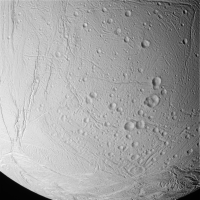
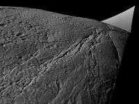
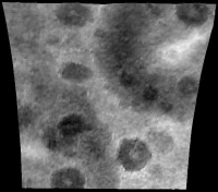
Earlier in this thread I mentioned Enceladus and Europa. If it's not too much work I would be very interested in seeing what a DEM of the attached image of Enceladus looks like. I have a DEM for a fairly big part of it (not near the bottom though) so a comparison would be interesting.
|
|
 |
 
|
|
|
Jan 19 2010, 03:43 PM
Post
#32
|
|||||||
|
Member Group: Members Posts: 713 Joined: 30-March 05 Member No.: 223 |
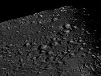
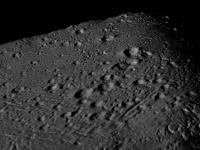
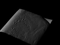
QUOTE (Bjorn Jonsson @ Jan 19 2010, 02:00 AM)  Earlier in this thread I mentioned Enceladus and Europa. If it's not too much work I would be very interested in seeing what a DEM of the attached image of Enceladus looks like. I have a DEM for a fairly big part of it (not near the bottom though) so a comparison would be interesting. ok, no problem: here I generated some views of it in 3D 
P.S.: one nice thing about the algorithm is that one does not need to specify any external calibration parameters, like the light source (sun incidence and azimut) direction.( because those are estimated simultaneously with the recoverered 3D surface ) So it can be applied to any arbitrary 2D image without knowledge about the exact viewing conditions. |
||||||
|
|
|
||||||
|
Jan 19 2010, 04:19 PM
Post
#33
|
|
|
Founder Group: Chairman Posts: 14433 Joined: 8-February 04 Member No.: 1 |
OK - yeah - do you think you'll be able to share the software and technique at some point? I have enough ideas for this that would keep you on your toes till April
|
|
|
|
|
Jan 19 2010, 05:37 PM
Post
#34
|
|
|
IMG to PNG GOD Group: Moderator Posts: 2251 Joined: 19-February 04 From: Near fire and ice Member No.: 38 |
QUOTE (Nirgal @ Jan 19 2010, 03:43 PM) ok, no problem: here I generated some views of it in 3D *Jaw drops to the floor*  This is awesome, probably the most interesting UMSF-member-developed software I have seen in the history of UMSF so I can simply repeat what Doug said above (actually I could probably keep you busy till April *next* year or longer ;-). If I could combine output from SFS with the output from my steromatcher I'd get DEMs of probably something like 10 times higher resolution than I have ever dreamt of. Combining DEMs like this is probably not difficult. If you manage to get this to work the way you want to there are lots of people here who would love to test it. And I would make my stereomatcher available - would need to spruce it up a lot though and it still has some bugs and quirks. Combining results from these two approaches opens up *lots* of possibilities. In particular, the low frequency variations from my software are pretty accurate (how accurate depends largely on how accurate the viewing geometry information is) while high frequency details are a problem and frequently 'disappear'. QUOTE (Nirgal @ Jan 19 2010, 03:43 PM) P.S.: one nice thing about the algorithm is that one does not need to specify any external calibration parameters, like the light source (sun incidence and azimut) direction.( because those are estimated simultaneously with the recoverered 3D surface ) In contrast my stereomatcher needs accurate viewing geometry information, field of view etc. Inaccurate viewing geometry information typically manifests itself as a 'tilted' DEM. |
|
|
|
|
Jan 19 2010, 05:47 PM
Post
#35
|
|
|
Founder Group: Chairman Posts: 14433 Joined: 8-February 04 Member No.: 1 |
Things I want to try ( in no particular order )
Topography of rocks using MER MI and Pancam imagery Height maps of MER sites using vertical projection mosaics Produce DEM's from HiRISE of the Mars Pathfinder landing site, and the full Opportunity site ( from Eagle all the way to Victoria ) as well as Phoenix and Viking sites |
|
|
|
|
Jan 19 2010, 06:23 PM
Post
#36
|
|
|
Senior Member Group: Members Posts: 2517 Joined: 13-September 05 Member No.: 497 |
Not to be dismissive of this, but as Nirgal pointed out himself, SFS/photoclinometry has been used in the planetary science community for a long time but just isn't very accurate in a lot of cases. While it may be sufficient for pretty visualizations, do you have any sense for how truly accurate your algorithm is?
-------------------- Disclaimer: This post is based on public information only. Any opinions are my own.
|
|
|
|
|
Jan 19 2010, 06:38 PM
Post
#37
|
|
 Senior Member Group: Admin Posts: 4763 Joined: 15-March 05 From: Glendale, AZ Member No.: 197 |
Since we have a lot of examples of places with very detailed and accurate DEMs it would be interesting to try this process on single images of those areas and compare the two methods. Columbia Hills comes to mind. I think we have flyover DEM of that around here somewhere
-------------------- If Occam had heard my theory, things would be very different now.
|
|
|
|
|
Jan 19 2010, 09:27 PM
Post
#38
|
|
|
Member Group: Members Posts: 713 Joined: 30-March 05 Member No.: 223 |
QUOTE (mcaplinger @ Jan 19 2010, 07:23 PM) Not to be dismissive of this, but as Nirgal pointed out himself, SFS/photoclinometry has been used in the planetary science community for a long time but just isn't very accurate in a lot of cases. While it may be sufficient for pretty visualizations, do you have any sense for how truly accurate your algorithm is? That's right: the main application of the algorithm (at least in its current form) is clearly the area of plausible visualization in near-photorealistic image resolution. (and that's the application that I'm personally most interested in) In this area it seems to be a very interesting tool to visually explore and display the huge space imaging datasets, particularly when there is no other 3D cue like altimeter or stereo data available. The question of actual physical accuracy however, is much more difficult to answer. In this regard, there are clear limitations to any shape-from-single-image methodology as already pointed out. This is where the already mentioned combination with low-res but more accurate data (altimeter, stereo) comes into play ... So in summary: yes, this project (in its current state) is intended primarily as a means of visualization, not so much as a scientific measuring instrument (of which there are already many other and better possibilities). For me, it has been an old childhood dream to literally "wander into" and "bring to live" the images that were sent back by our space probes ... images to fuel the imagination of space exploration |
|
|
|
|
Jan 19 2010, 09:30 PM
Post
#39
|
|
 Senior Member Group: Members Posts: 1619 Joined: 12-February 06 From: Bergerac - FR Member No.: 678 |
 ASTOUNDING ! AMAZING ! You just did a WONDERFUL work Nirgal Absolument magnifique ! I want to view more about that 
-------------------- |
|
|
|
|
Jan 19 2010, 09:35 PM
Post
#40
|
|
 The Poet Dude Group: Moderator Posts: 5551 Joined: 15-March 04 From: Kendal, Cumbria, UK Member No.: 60 |
You keep sharing your "pretty visualisations" Nirgal; 1000% accurate or not, we're all loving them!
I have a list of requests too, but they'll keep. I'm sure there's a queue! 
-------------------- |
|
|
|
|
Jan 19 2010, 11:05 PM
Post
#41
|
|||
|
IMG to PNG GOD Group: Moderator Posts: 2251 Joined: 19-February 04 From: Near fire and ice Member No.: 38 |
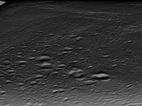
There are lots and lots of things I'd be interested in testing but I'm posting just a single image to test if it's not too much trouble. What I'm posting here has been carefully selected to ensure I shouldn't have to post more stuff to test, at least not in the near term (although testing how the SFS software performs with the sun almost directly overhead would be interesting as well, my stereomatcher performs poorly in that case for obvious reasons).
This is a Cassini image of Rhea with the Tirawa impact basin partially visible in the upper right quadrant:
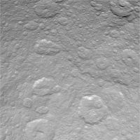
I would be very interested in seeing a DEM from this image. What would be most interesting, if possible, would be a 1024x1024 pixel 16 bit grayscale DEM as a tiff or png file. If this is possible I'll attempt to merge it into my global DEM of Rhea that I made using stereo pairs. That would combine the best of both worlds and I would post the results here. Otherwise some test renders would be nice. This is a portion of my DEM of Rhea showing most of the image above (it's slightly cropped):
Here black represents -6.320 km and white 6.176 km relative to an ellipsoid. Unlike the Cassini image above, this 'image' is in simple cylindrical projection and covers longitude 150.25 to 187.875 degrees and latitude 8.625 to 41.625 degrees (including the black stuff surrounding the DEM). |
||
|
|
|
||
|
Jan 20 2010, 08:37 AM
Post
#42
|
|
 Senior Member Group: Members Posts: 1089 Joined: 19-February 05 From: Close to Meudon Observatory in France Member No.: 172 |
QUOTE (djellison @ Jan 19 2010, 06:47 PM) Things I want to try ( in no particular order ) Topography of rocks using MER MI and Pancam imagery Height maps of MER sites using vertical projection mosaics Produce DEM's from HiRISE of the Mars Pathfinder landing site, and the full Opportunity site ( from Eagle all the way to Victoria ) as well as Phoenix and Viking sites Exactly the same needs for me ! => Is your software working also on a Windows environment (to be more easily carried on a portable home computer when travelling) ? Bravo ! Encore ! 
|
|
|
|
|
Jan 20 2010, 10:09 AM
Post
#43
|
|
|
Member Group: Members Posts: 378 Joined: 21-April 05 From: Portugal Member No.: 347 |
I'd VERY much like to produce a detailed DEM from the Magellan Venus radar images, such as Maxwell Montes: http://photojournal.jpl.nasa.gov/catalog/PIA00149
I think that small scale topography could be recovered by SFS / photoclinometry algorithms and integrated into the low resolutions altimetry data we already have. That would reduce artifacts introduced by surface "albedo" changes, as we would only be recovering small scale local terrain features. Anyone tried something like it? -------------------- _______________________
www.astrosurf.com/nunes |
|
|
|
|
Jan 20 2010, 01:56 PM
Post
#44
|
|
|
Founder Group: Chairman Posts: 14433 Joined: 8-February 04 Member No.: 1 |
I'm not sure this would work on Radar.
|
|
|
|
|
Jan 20 2010, 02:13 PM
Post
#45
|
|
|
Member Group: Members Posts: 378 Joined: 21-April 05 From: Portugal Member No.: 347 |
It should work on radar, as there's the concept of "radar illumination".
See here: http://www.ccrs.nrcan.gc.ca/glossary/index_e.php?id=2844 Of course, having the "light" coming from an orbiting (moving) spacecraft is not the same as from a single distant light source, but you still have higher or lower reflections according to the surface angle. So in theory you could recover some information from those radar images, at least better than the global altimetry we have. -------------------- _______________________
www.astrosurf.com/nunes |
|
|
|
|

|
Lo-Fi Version | Time is now: 5th June 2024 - 08:14 AM |
|
RULES AND GUIDELINES Please read the Forum Rules and Guidelines before posting. IMAGE COPYRIGHT |
OPINIONS AND MODERATION Opinions expressed on UnmannedSpaceflight.com are those of the individual posters and do not necessarily reflect the opinions of UnmannedSpaceflight.com or The Planetary Society. The all-volunteer UnmannedSpaceflight.com moderation team is wholly independent of The Planetary Society. The Planetary Society has no influence over decisions made by the UnmannedSpaceflight.com moderators. |
SUPPORT THE FORUM Unmannedspaceflight.com is funded by the Planetary Society. Please consider supporting our work and many other projects by donating to the Society or becoming a member. |
|