Dawn Survey Orbit Phase, First orbital phase |

  |
Dawn Survey Orbit Phase, First orbital phase |
 Jul 19 2011, 04:33 PM Jul 19 2011, 04:33 PM
Post
#46
|
||
|
Solar System Cartographer  Group: Members Posts: 10189 Joined: 5-April 05 From: Canada Member No.: 227 |
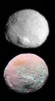
Here's a composite to illustrate that.
Phil
-------------------- ... because the Solar System ain't gonna map itself.
Also to be found posting similar content on https://mastodon.social/@PhilStooke Maps for download (free PD: https://upload.wikimedia.org/wikipedia/comm...Cartography.pdf NOTE: everything created by me which I post on UMSF is considered to be in the public domain (NOT CC, public domain) |
|
 |
 
|
|
|
Jul 19 2011, 04:51 PM
Post
#47
|
|
 Administrator Group: Admin Posts: 5172 Joined: 4-August 05 From: Pasadena, CA, USA, Earth Member No.: 454 |
QUOTE (Stefan @ Jul 19 2011, 05:22 AM)  The last few images were enlarged by an integer factor. Did you find something wrong with how they were enlarged? The most recent one wasn't -- its enlargement factor was something around 2.2. And the resolutions stated (and widely requoted) in all the released captions are just wrong. With spherical bodies it is very easy to back out an accurate image resolution from a global image -- measure any diameter and you're done. But for bodies with very different principal axis lengths, especially irregular ones like Vesta, it's hard to do this accurately, which prevents me from doing size comparisons. Size comparison posts are some of the most popular things that I do, which is why this is driving me so crazy. As of yesterday I think the press person at JPL now understands what I am complaining about, so hopefully we'll see captions fixed soon. Of course what I really want is for them to quit enlarging the released images. -------------------- My website - My Patreon - @elakdawalla on Twitter - Please support unmannedspaceflight.com by donating here.
|
|
|
|
|
Jul 19 2011, 04:52 PM
Post
#48
|
|
|
Member Group: Members Posts: 146 Joined: 31-October 08 Member No.: 4473 |
QUOTE (Phil Stooke @ Jul 19 2011, 08:11 AM) Nice one, Mike. The orange spot in the false color view coincides with the darker spot seen in distant views, including the 'crater with tails' as someone described it, on the edge of the smooth patch we saw a while ago. Phil The orange area is around the sub-solar point, so I think it just represents daytime heating. Over time, a strong lead or lag behind nearby features with different times-of-day (Vesta Sols!) would be very interesting. |
|
|
|
|
Jul 19 2011, 07:14 PM
Post
#49
|
|
|
Junior Member Group: Members Posts: 52 Joined: 16-November 06 Member No.: 1364 |
QUOTE (elakdawalla @ Jul 19 2011, 06:51 PM) The most recent one wasn't -- its enlargement factor was something around 2.2. And the resolutions stated (and widely requoted) in all the released captions are just wrong. This image was enlarged by a factor 2 (I know because I enlarged it). The resolution of the image as shown here is actually close to the quoted value. But what do you think of the caption here? The media will take that image and do with it whatever they like, and then quote the original numbers. Yes, I understand your concern about the caption, and no, I didn't write it. |
|
|
|
|
Jul 19 2011, 09:18 PM
Post
#50
|
|
|
Administrator Group: Admin Posts: 5172 Joined: 4-August 05 From: Pasadena, CA, USA, Earth Member No.: 454 |
You did the enlargement? It's great to actually talk to someone who knows what's going on
 So tell me where I'm wrong here. The diameter of Vesta in that released image is 860 pixels. At 700 m/pixel (1.4 / 2x enlargement) that gives you 600 km diameter, which I *think* is much too large. So tell me where I'm wrong here. The diameter of Vesta in that released image is 860 pixels. At 700 m/pixel (1.4 / 2x enlargement) that gives you 600 km diameter, which I *think* is much too large.If the pixel scale were rounded incorrectly and the original image scale were 1.3 km/pixel then it would correspond to 560 km diameter, which is within the accepted range of Vestian diameters... You're right that reporting pixel scales will inevitably result in mainstream media screwing things up. For that reason I'd actually advocate abandoning pixel scales -- ONLY IF the images get released at their original resolution, or if they are enlarged by whole-number factors that are stated in released captions. Those of us who care about these things will get the numbers right. -------------------- My website - My Patreon - @elakdawalla on Twitter - Please support unmannedspaceflight.com by donating here.
|
|
|
|
|
Jul 19 2011, 11:39 PM
Post
#51
|
||
 Senior Member Group: Moderator Posts: 2785 Joined: 10-November 06 From: Pasadena, CA Member No.: 1345 |
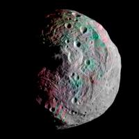
Here's a mashup of the image on the DLR website with high-resolution image PIA14313. I took the enhanced-color IR composite and broke it up into little chunks, then took each chunk and warped it to try to align with surface features in the high res image. Reassembled the color composite, then used that to blend to the high-res layer underneath. Full details on flickr (here)
Neat how the scarp and some of the craters and ejecta are greenish in the IR composite.
-------------------- Some higher resolution images available at my photostream: http://www.flickr.com/photos/31678681@N07/
|
|
|
|
|
|
|
Jul 20 2011, 07:26 AM
Post
#52
|
||
 Senior Member Group: Members Posts: 2492 Joined: 15-January 05 From: center Italy Member No.: 150 |
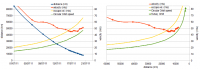
An update on Dawn trajectory:
in spite of engine running in last 20 hours, the probe is gently accelerating, progressively approaching a "circular orbit speed", as showed below:
The green triangles indicates definitive survey orbit; they are two because I'm not sure if 2700km nominal height is referred to the center or the surface of Vesta... can someone help me?  As additional info, now average acceleration toward Vesta is 3e-5 m/s2 while angle between trajectory and Vesta-to-Dawn vector is approaching 70°. Addendum: I do not share Emily's bad feeling about image release policy... look to the bright side, last released image was captured only 3 days before and also contrast/gamma is a lot better than previous ones!
-------------------- I always think before posting! - Marco -
|
|
|
|
|
|
|
Jul 20 2011, 02:13 PM
Post
#53
|
|
|
Senior Member Group: Members Posts: 1018 Joined: 29-November 05 From: Seattle, WA, USA Member No.: 590 |
Another interesting stat might be energy/kilogram. Although kinetic energy is increasing, potential energy is decreasing.
--Greg |
|
|
|
|
Jul 20 2011, 03:20 PM
Post
#54
|
|
|
Junior Member Group: Members Posts: 52 Joined: 16-November 06 Member No.: 1364 |
QUOTE (elakdawalla @ Jul 19 2011, 11:18 PM) You did the enlargement? It's great to actually talk to someone who knows what's going on So tell me where I'm wrong here. The diameter of Vesta in that released image is 860 pixels. At 700 m/pixel (1.4 / 2x enlargement) that gives you 600 km diameter, which I *think* is much too large.The distance for that image was (or should have been) 15222 km (center of Vesta). You already know the angular extent of one pixel. You tell me where you are wrong...  We are working to improve the caption. Again, I ask you if you think the enlargement of the last image was done badly. Reading your blog, I am not sure. I used the Mitchell-Netravali algorithm, which I think is appropriate. Remember, it is a tradeoff between blurriness and jagged edge. |
|
|
|
|
Jul 20 2011, 03:29 PM
Post
#55
|
|
|
Founder Group: Chairman Posts: 14433 Joined: 8-February 04 Member No.: 1 |
QUOTE (Stefan @ Jul 20 2011, 07:20 AM) Again, I ask you if you think the enlargement of the last image was done badly. Why is it being done at all? If (as we have been told) there is a constraint on the teams time in producing images for outreach...why waste some of that precious time in un-necessarily enlarging these images? |
|
|
|
|
Jul 20 2011, 03:49 PM
Post
#56
|
|
 Senior Member Group: Members Posts: 3648 Joined: 1-October 05 From: Croatia Member No.: 523 |
To be fair, that practice of magnifying otherwise poststamp-sized images is pretty much the norm for NASA image advisories, although they do tend to specify the magnification factor in most cases.
-------------------- |
|
|
|
|
Jul 20 2011, 06:09 PM
Post
#57
|
|
 Member Group: Members Posts: 796 Joined: 27-February 08 From: Heart of Europe Member No.: 4057 |
Enlarging images is standard procedure. NASA use that, almost every amateur processor use that. When one is working with mosaic from multiple images, then resizing is even necessary. When one have post-stamp size image, enlarged variant looks somewhat better, than original one.
"waste some of that precious time" It's not, in IrfanView (my favorite software for resampling images) it's matter of seconds. "I used the Mitchell-Netravali algorithm, which I think is appropriate." Mitchell is fine, it's my favorite one, but I think, that it isn't what Emily is complaining about. She simply need information about actual size of pixels, that's all. -------------------- |
|
|
|
|
Jul 20 2011, 09:41 PM
Post
#58
|
|||
|
Member Group: Members Posts: 796 Joined: 27-February 08 From: Heart of Europe Member No.: 4057 |
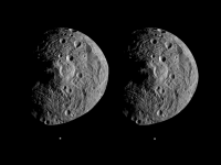
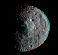
South pole of Vesta in stereo. Cross eye and anaglyph version. Resolution is approx. 1 km/pix.
Stereo images were made from one published hi-res image and synthetic image (made from both published hi-res images).
Attached thumbnail(s)
-------------------- |
||
|
|
|
||
|
Jul 20 2011, 09:48 PM
Post
#59
|
|
|
Senior Member Group: Members Posts: 1276 Joined: 25-November 04 Member No.: 114 |
machi Thank you for the 3D!
My kids appreciate it also! |
|
|
|
|
Jul 20 2011, 10:11 PM
Post
#60
|
|
|
Solar System Cartographer Group: Members Posts: 10189 Joined: 5-April 05 From: Canada Member No.: 227 |
Fantastic! Thanks.
Phil -------------------- ... because the Solar System ain't gonna map itself.
Also to be found posting similar content on https://mastodon.social/@PhilStooke Maps for download (free PD: https://upload.wikimedia.org/wikipedia/comm...Cartography.pdf NOTE: everything created by me which I post on UMSF is considered to be in the public domain (NOT CC, public domain) |
|
|
|
|

|
Lo-Fi Version | Time is now: 8th June 2024 - 06:22 AM |
|
RULES AND GUIDELINES Please read the Forum Rules and Guidelines before posting. IMAGE COPYRIGHT |
OPINIONS AND MODERATION Opinions expressed on UnmannedSpaceflight.com are those of the individual posters and do not necessarily reflect the opinions of UnmannedSpaceflight.com or The Planetary Society. The all-volunteer UnmannedSpaceflight.com moderation team is wholly independent of The Planetary Society. The Planetary Society has no influence over decisions made by the UnmannedSpaceflight.com moderators. |
SUPPORT THE FORUM Unmannedspaceflight.com is funded by the Planetary Society. Please consider supporting our work and many other projects by donating to the Society or becoming a member. |
|