Cape York - Shoemaker Ridge and the NE traverse, Starting sol 2735 |

  |
Cape York - Shoemaker Ridge and the NE traverse, Starting sol 2735 |
 Oct 10 2011, 04:38 AM Oct 10 2011, 04:38 AM
Post
#46
|
|
 Senior Member  Group: Members Posts: 4247 Joined: 17-January 05 Member No.: 152 |
Yep - I don't recall a group of globby cobbles quite like that.
This frame's looking farther up CY towards the main clay signature area: http://qt.exploratorium.edu/mars/opportuni...0M1.JPG?sol2740 |
 |
 
|
|
Oct 10 2011, 04:54 AM
Post
#47
|
|
 Senior Member Group: Moderator Posts: 3431 Joined: 11-August 04 From: USA Member No.: 98 |
Where do you even start with a place like this? Will be interesting to see what happens next.
Edit: Well, start with some Pancam, hopefully 
|
|
|
|
|
Oct 10 2011, 05:13 AM
Post
#48
|
|
|
Senior Member Group: Moderator Posts: 3431 Joined: 11-August 04 From: USA Member No.: 98 |
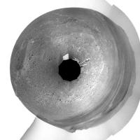
Here's a version of the 360x80 degree Navcam anaglyph with image sharpened and focal point a bit farther out. (I'm fascinated by the topography to the north-northeast.)
|
|
|
|
|
Oct 10 2011, 06:05 AM
Post
#49
|
|
|
Senior Member Group: Members Posts: 2998 Joined: 30-October 04 Member No.: 105 |
Curious, yes. Note that the cobbles all have a light area on one end. First thought was "ah, a specular reflection", but in an L0 Navcam, light=reddish so it's an "ocher" spot. Given the orientation, they seem to be in the "downwind" direction so it's in a wind-dead zone and light particles tend to collect and adhere or beind downwind, there is less aeolian abrasion and erosion. And in fredk's Navcam view, look at the ripple-forming sand plus the rounded cobbles, with a mix of particles like that, this is a area of active weathering and erosion. Unique area, and we've just now gotten here.
I'm hoping for a sidetrip to the spot with those rectangular lineations (which I'm informally calling "Secular City" til we get an official name) for a quick peek and close-in color views. That fascinating topography is in the direction of the dark-filled crater, "summit crater", informally. --Bill -------------------- |
|
|
|
|
Oct 10 2011, 06:48 AM
Post
#50
|
|
|
Senior Member Group: Moderator Posts: 4279 Joined: 19-April 05 From: .br at .es Member No.: 253 |
|
|
|
|
|
Oct 10 2011, 11:11 AM
Post
#51
|
|
|
Senior Member Group: Members Posts: 2998 Joined: 30-October 04 Member No.: 105 |
Good application of a circular panorama.
Compare with Phil's Cir_Pan of Mike's Sol-2710 Navcam pan: http://www.unmannedspaceflight.com/index.p...st&id=25510 (in post http://www.unmannedspaceflight.com/index.p...st&p=178440 ) -- you can tell we are no longer on the side of a hill, and you can just make out "summit crater" to the NNE. --Bill EDIT: and with Phil's current circular pan two posts down: http://www.unmannedspaceflight.com/index.p...st&id=25663 . Same data, different perspectives. -------------------- |
|
|
|
|
Oct 10 2011, 01:15 PM
Post
#52
|
|
|
Senior Member Group: Members Posts: 2922 Joined: 14-February 06 From: Very close to the Pyrénées Mountains (France) Member No.: 682 |
QUOTE (fredk @ Oct 10 2011, 01:25 AM)  I'm not sure if this will help, but generally the slopes are east facing here, although there are some "knobs" that might have north-facing slopes of varying degrees, that I've circled here: I'm thinking those are the areas they want to map carefully. I've got the point , thanks Fredk, this make sense now. -------------------- |
|
|
|
|
Oct 10 2011, 01:38 PM
Post
#53
|
||
|
Solar System Cartographer Group: Members Posts: 10173 Joined: 5-April 05 From: Canada Member No.: 227 |
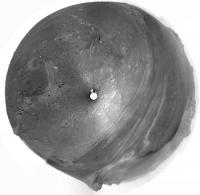
My version of mhoward's nice panorama in circular form.
Phil
-------------------- ... because the Solar System ain't gonna map itself.
Also to be found posting similar content on https://mastodon.social/@PhilStooke Maps for download (free PD: https://upload.wikimedia.org/wikipedia/comm...Cartography.pdf NOTE: everything created by me which I post on UMSF is considered to be in the public domain (NOT CC, public domain) |
|
|
|
|
|
|
Oct 10 2011, 04:59 PM
Post
#54
|
|
|
Senior Member Group: Members Posts: 2998 Joined: 30-October 04 Member No.: 105 |
I uploaded to the PhotoBucket site an index image of the area between Odyssey Crater and the "unnamed summit crater" in the CRISM clay area, in PNG format.
HiRISE image of part of Cape York, at Endeavour Crater. Cropped, sharpened and enhanced and map oriented. Covers MER traverse from Odyssey Crater to CRISM clay area Image ESP_024015_1775 _RED http://i142.photobucket.com/albums/r91/wil...maker_Ridge.png Somewhat grainy-looking, but I've concluded that this is due to sub-pixel light spots and dark cobbles on the ground pushing the average pixel value up or down. You can orient yourself using Tesheiner's Route Maps or with the Cir_Pans uploaded earlier. --Bill -------------------- |
|
|
|
| Guest_Sunspot_* |
Oct 10 2011, 05:22 PM
Post
#55
|
|
Guests |
Do those rectangular features correspond to the clay signature?
|
|
|
|
|
Oct 10 2011, 05:38 PM
Post
#56
|
|
|
Member Group: Members Posts: 910 Joined: 4-September 06 From: Boston Member No.: 1102 |
Nope, just the foundation stones of the old fort.

-------------------- |
|
|
|
|
Oct 10 2011, 07:10 PM
Post
#57
|
||
 Senior Member Group: Admin Posts: 4763 Joined: 15-March 05 From: Glendale, AZ Member No.: 197 |
Now we know where it landed after it was sent spinning.
Attached thumbnail(s)
-------------------- If Occam had heard my theory, things would be very different now.
|
|
|
|
|
|
|
Oct 10 2011, 08:12 PM
Post
#58
|
||
|
Senior Member Group: Members Posts: 4247 Joined: 17-January 05 Member No.: 152 |
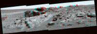
Nice view from sol 2736 showing Odyssey ejecta, then Odyssey itself, then Spirit Point on CY, and finally the jumbled terrain we zoomed over on our way in...
|
|
|
|
|
|
|
Oct 10 2011, 10:23 PM
Post
#59
|
||
|
Senior Member Group: Moderator Posts: 3431 Joined: 11-August 04 From: USA Member No.: 98 |
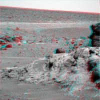
Not seamless, but... (Sol 2736 "Kirkland Lake" red-cyan anaglyph)
Attached thumbnail(s)
|
|
|
|
|
|
|
Oct 11 2011, 12:19 AM
Post
#60
|
|
|
Member Group: Members Posts: 204 Joined: 14-April 06 From: Seattle, WA Member No.: 745 |
QUOTE (Bill Harris @ Oct 9 2011, 10:05 PM) I'm hoping for a sidetrip to the spot with those rectangular lineations (which I'm informally calling "Secular City" til we get an official name) for a quick peek and close-in color views. Those 'rectangular lineations' look a lot like the cemented fractures in Gale Crater. Description of cemented fractures.  They don't say anything about clay in the image caption, but it is evidence of water. My guess the MER team will want to take a look at this feature; maybe Oppy will scoop MSL. Anyway, I hope so too. Go Oppy, go! 
|
|
|
|
|

|
Lo-Fi Version | Time is now: 1st June 2024 - 05:11 AM |
|
RULES AND GUIDELINES Please read the Forum Rules and Guidelines before posting. IMAGE COPYRIGHT |
OPINIONS AND MODERATION Opinions expressed on UnmannedSpaceflight.com are those of the individual posters and do not necessarily reflect the opinions of UnmannedSpaceflight.com or The Planetary Society. The all-volunteer UnmannedSpaceflight.com moderation team is wholly independent of The Planetary Society. The Planetary Society has no influence over decisions made by the UnmannedSpaceflight.com moderators. |
SUPPORT THE FORUM Unmannedspaceflight.com is funded by the Planetary Society. Please consider supporting our work and many other projects by donating to the Society or becoming a member. |
|