MSL Post First Drive - Intermission, Start of Drive to Glenelg, Intermission between CAP 1B and 2 - Sols 17 through 29 |

  |
MSL Post First Drive - Intermission, Start of Drive to Glenelg, Intermission between CAP 1B and 2 - Sols 17 through 29 |
 Aug 27 2012, 07:44 PM Aug 27 2012, 07:44 PM
Post
#76
|
||
 Senior Member  Group: Admin Posts: 4763 Joined: 15-March 05 From: Glendale, AZ Member No.: 197 |
QUOTE (fredk @ Aug 27 2012, 07:22 AM)  There are now three of us (yourself, ugordan, and myself) who obtained similar results on demosaicing using very different approaches. UMSF: Providing headache relief for space image fans everywhere.
Attached thumbnail(s)
-------------------- If Occam had heard my theory, things would be very different now.
|
|
 |
 
|
|
|
Aug 27 2012, 09:06 PM
Post
#77
|
|
 Member Group: Members Posts: 701 Joined: 3-December 04 From: Boulder, Colorado, USA Member No.: 117 |
QUOTE (Stu @ Aug 27 2012, 12:22 PM) Actually, if you run that shirt through a deBayer filter it looks quite nice...  Of course- it's actually a tie-dye!
|
|
|
|
|
Aug 27 2012, 09:13 PM
Post
#78
|
|
|
Newbie Group: Members Posts: 17 Joined: 28-May 08 Member No.: 4149 |
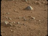
Pic from todays briefing: http://i.imgur.com/76icp.jpg
Just wow. edit: on the site now: http://mars.jpl.nasa.gov/msl/multimedia/images/?ImageID=4569 |
|
|
|
|
Aug 27 2012, 09:34 PM
Post
#79
|
|
|
Junior Member Group: Members Posts: 26 Joined: 7-August 12 Member No.: 6485 |
From the Press conference - the animation they showed implied that MRO and Ody have quite a lot of overlap in their overpasses (i.e. there are times when they're both over the horizon at the same time). Can Curiosity relay different streams to each of them to maximise bandwidth?
|
|
|
|
|
Aug 27 2012, 09:40 PM
Post
#80
|
|
|
Solar System Cartographer Group: Members Posts: 10173 Joined: 5-April 05 From: Canada Member No.: 227 |
... and they have now driven to a point where DAN can get data from one of the scours. There for a few sols, then head for Glenelg.
Phil -------------------- ... because the Solar System ain't gonna map itself.
Also to be found posting similar content on https://mastodon.social/@PhilStooke Maps for download (free PD: https://upload.wikimedia.org/wikipedia/comm...Cartography.pdf NOTE: everything created by me which I post on UMSF is considered to be in the public domain (NOT CC, public domain) |
|
|
|
|
Aug 27 2012, 10:00 PM
Post
#81
|
|
|
Senior Member Group: Moderator Posts: 4279 Joined: 19-April 05 From: .br at .es Member No.: 253 |
QUOTE (Josh Cryer @ Aug 27 2012, 11:13 PM) Pic from todays briefing: http://i.imgur.com/76icp.jpg Just wow. edit: on the site now: http://mars.jpl.nasa.gov/msl/multimedia/images/?ImageID=4569 And to have a sense of scale, just look to the "tiny" rock almost dead centered on the picture at x, y coordinates 534,328. That's the rover-sized rock Mike Malin talked about. Incredible! |
|
|
|
|
Aug 27 2012, 10:05 PM
Post
#82
|
|
|
Merciless Robot Group: Admin Posts: 8784 Joined: 8-December 05 From: Los Angeles Member No.: 602 |
Phenomenal.
We're in the right place with the right rover.
-------------------- A few will take this knowledge and use this power of a dream realized as a force for change, an impetus for further discovery to make less ancient dreams real.
|
|
|
|
|
Aug 27 2012, 11:22 PM
Post
#83
|
|
 Senior Member Group: Members Posts: 1619 Joined: 12-February 06 From: Bergerac - FR Member No.: 678 |
Sol 21 Navcam pan, in anaglyph. Classic version available on the link :
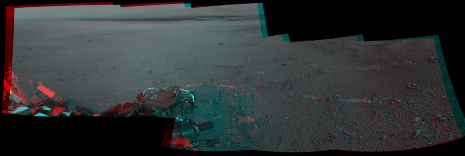 Also, that was a great press briefing, especially the part with the "badlands" and the rover-scalled-rock.
-------------------- |
|
|
|
|
Aug 27 2012, 11:26 PM
Post
#84
|
|
 Senior Member Group: Members Posts: 1641 Joined: 5-March 05 From: Boulder, CO Member No.: 184 |
And nice at the briefing to see John Grotzinger talk about the large unconformity on Mt. Sharp (earlier mentioned in UMSF by Emily, and asked about by her at the press conference) and to compare it with the Grand Canyon.
-------------------- Steve [ my home page and planetary maps page ]
|
|
|
|
|
Aug 28 2012, 12:02 AM
Post
#85
|
|
 Junior Member Group: Members Posts: 81 Joined: 10-August 12 From: Kingston, Ontario, Canada Member No.: 6534 |
Thanks, Ant, that stereo panorama looks great through shutter glasses, here is the .jps file if anyone else has a 3D display (assuming I have Ant's permission!).
https://dl.dropbox.com/u/97443049/Sol21_pano_ana.JPS |
|
|
|
|
Aug 28 2012, 01:20 AM
Post
#86
|
|||
 Senior Member Group: Members Posts: 1465 Joined: 9-February 04 From: Columbus OH USA Member No.: 13 |
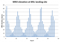
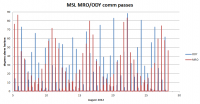
QUOTE (charleski @ Aug 27 2012, 05:34 PM) From the Press conference - the animation they showed implied that MRO and Ody have quite a lot of overlap in their overpasses... It's pretty rare that they're both up at the same time, based on the NAIF data published. It's probably more important that they fill each other's gaps. MRO has an interesting pattern:
So there's about a 6-day periodicity. ODY passes are a little less regular, but put them together & you get this for August to date:
The graphs show the passes at night too. I think they've used some of those. -------------------- |
||
|
|
|
||
|
Aug 28 2012, 02:00 AM
Post
#87
|
|
|
Member Group: Members Posts: 866 Joined: 15-March 05 From: Santa Cruz, CA Member No.: 196 |
QUOTE (Josh Cryer @ Aug 27 2012, 02:13 PM) beautiful! it would seem that MAHLI doc at section 6.1 example picture of the Chinle Formation is now seeming quite prescient indeed given the scenery were already seeing! |
|
|
|
|
Aug 28 2012, 02:51 AM
Post
#88
|
|
 Senior Member Group: Members Posts: 2228 Joined: 1-December 04 From: Marble Falls, Texas, USA Member No.: 116 |
QUOTE (scalbers @ Aug 27 2012, 06:26 PM) ...nice at the briefing to see John Grotzinger talk about the large unconformity on Mt. Sharp ... I think we are seeing several significant unconformities in the stack and a number of minor ones. I was considering doing a stratigraphic sketch, but it is so difficult to see most of the mound clearly. I hope we don't have to wait too long for a pristine view.   -------------------- ...Tom
I'm not a Space Fan, I'm a Space Exploration Enthusiast. |
|
|
|
|
Aug 28 2012, 12:46 PM
Post
#89
|
|
|
Junior Member Group: Members Posts: 59 Joined: 12-March 10 From: Austin, TX Member No.: 5262 |
In response to the last question about sunrise at Gale, I later thought a sunset picture with the silhouette of the rim against Sharp while the basin was dark might look cool. Given the low atmospheric pressure and subsequent low scattering, it might be pretty dramatic. And Curiosity should be able to take such a picture given where it's located.
|
|
|
|
|
Aug 28 2012, 02:59 PM
Post
#90
|
|||
 Senior Member Group: Members Posts: 4247 Joined: 17-January 05 Member No.: 152 |
Pressure is low but dust is high, so scattering tends to be high. Not to say that low-sun shots aren't dramatic, of course...
A couple of new de-Bayered mastcam 100 views from sol 17, both Fourier filtered to reduce jpeg artifacts:
Near centre in that last frame: how about "whitecap" for a nickname? |
||
|
|
|
||
|

|
Lo-Fi Version | Time is now: 31st May 2024 - 11:59 PM |
|
RULES AND GUIDELINES Please read the Forum Rules and Guidelines before posting. IMAGE COPYRIGHT |
OPINIONS AND MODERATION Opinions expressed on UnmannedSpaceflight.com are those of the individual posters and do not necessarily reflect the opinions of UnmannedSpaceflight.com or The Planetary Society. The all-volunteer UnmannedSpaceflight.com moderation team is wholly independent of The Planetary Society. The Planetary Society has no influence over decisions made by the UnmannedSpaceflight.com moderators. |
SUPPORT THE FORUM Unmannedspaceflight.com is funded by the Planetary Society. Please consider supporting our work and many other projects by donating to the Society or becoming a member. |
|