MSL "Drive, drive, drive" toward Glenelg, The scientists (mostly) get the keys - sols 38-56 |

  |
MSL "Drive, drive, drive" toward Glenelg, The scientists (mostly) get the keys - sols 38-56 |
 Sep 18 2012, 03:06 PM Sep 18 2012, 03:06 PM
Post
#76
|
|
 Senior Member  Group: Moderator Posts: 3431 Joined: 11-August 04 From: USA Member No.: 98 |
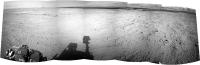
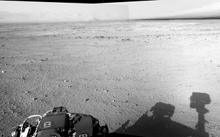
From Sol 42:
  |
 |
 
|
|
Sep 18 2012, 03:19 PM
Post
#77
|
|
 Senior Member Group: Members Posts: 4249 Joined: 17-January 05 Member No.: 152 |
QUOTE (dvandorn @ Sep 18 2012, 02:49 PM)  I'm assuming that the marked areas in the next two images, from above and from the surface, are the same feature? Nope - that mastcam mosaic is looking west.
|
|
|
|
|
Sep 18 2012, 03:29 PM
Post
#78
|
|
 Senior Member Group: Members Posts: 3419 Joined: 9-February 04 From: Minneapolis, MN, USA Member No.: 15 |
QUOTE (fredk @ Sep 18 2012, 10:19 AM) Nope - that mastcam mosaic is looking west. Okay. In that case, I'm finding it really difficult finding the feature in the surface image in the overhead context. And, correct me if I'm wrong, but while the feature I marked in the overhead was more north of us at the Sol 40 position, is it not west-northwest of us now? I suppose the mastcam mosaic in question was taken well before either of those two stops, though. Ah, well. The surface feature still looks interestingly like some kind of cemented underfloor. -the other Doug -------------------- The trouble ain't that there is too many fools, but that the lightning ain't distributed right. -Mark Twain
|
|
|
|
|
Sep 18 2012, 04:02 PM
Post
#79
|
|
|
Solar System Cartographer Group: Members Posts: 10180 Joined: 5-April 05 From: Canada Member No.: 227 |
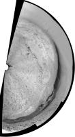
Doug - see my route map... the outcrop is due south of the sol 24 position near the SW corner of my map. I suppose it might be looked at on the way back from Glenelg towards the main science area to the west.
Phil -------------------- ... because the Solar System ain't gonna map itself.
Also to be found posting similar content on https://mastodon.social/@PhilStooke Maps for download (free PD: https://upload.wikimedia.org/wikipedia/comm...Cartography.pdf NOTE: everything created by me which I post on UMSF is considered to be in the public domain (NOT CC, public domain) |
|
|
|
|
Sep 18 2012, 04:04 PM
Post
#80
|
|
 Senior Member Group: Members Posts: 2173 Joined: 28-December 04 From: Florida, USA Member No.: 132 |
QUOTE (dvandorn @ Sep 18 2012, 10:29 AM) Okay. In that case, I'm finding it really difficult finding the feature.... Did you check the image linked here?
|
|
|
|
|
Sep 18 2012, 04:24 PM
Post
#81
|
|
 Member Group: Members Posts: 276 Joined: 11-December 07 From: Dar es Salaam, Tanzania Member No.: 3978 |
QUOTE (akuo @ Sep 18 2012, 03:22 PM) Sol 42 drive images are up. The shadows are long and the dynamic range in the navcam images appears quite high. We've been roving late into the afternoon? I actually thought there had been a change in the camera's default brightness/contrast settings! 
-------------------- |
|
|
|
|
Sep 18 2012, 04:24 PM
Post
#82
|
|
|
Senior Member Group: Members Posts: 3419 Joined: 9-February 04 From: Minneapolis, MN, USA Member No.: 15 |
QUOTE (Phil Stooke @ Sep 18 2012, 11:02 AM) Doug - see my route map... the outcrop is due south of the sol 24 position near the SW corner of my map. Thanks! It can be a little difficult recognizing these flat-to-the-ground features from above, can't it? -the other Doug -------------------- The trouble ain't that there is too many fools, but that the lightning ain't distributed right. -Mark Twain
|
|
|
|
|
Sep 18 2012, 04:39 PM
Post
#83
|
|
|
Member Group: Members Posts: 470 Joined: 24-March 04 From: Finland Member No.: 63 |
QUOTE (Doc @ Sep 18 2012, 04:24 PM) I actually thought there had been a change in the camera's default brightness/contrast settings! While the lighting conditions do have an effect, the thinking is that there has been change to the contrast stretch and jpeg quality in the released "raw" images. See the discussion here: http://www.unmannedspaceflight.com/index.p...mp;#entry191664 -------------------- Antti Kuosmanen
|
|
|
|
|
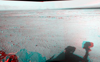
Sep 18 2012, 05:31 PM
Post
#84
|
||
|
Senior Member Group: Members Posts: 1074 Joined: 21-September 07 From: Québec, Canada Member No.: 3908 |
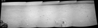
Here is a wider panorama of sol 42 navcams:
There is something I don't understand on the MSL raw images page:http://mars.jpl.nasa.gov/msl/multimedia/raw/. The number of images in the list does not reflect the actual number of images visible. For example, for the front hazcam the list says "Sol 042 (4 img)". When I click on the link, I see only one "Full data product" and one "Thumbnail data product". This happens in many places. I'm just curious to know the reason for the discrepancy. |
|
|
|
|
|
|
Sep 18 2012, 05:32 PM
Post
#85
|
|
 Senior Member Group: Members Posts: 1619 Joined: 12-February 06 From: Bergerac - FR Member No.: 678 |
So, even if this tosol pics are to stretched from my point of view, here is the Sol 42 navcam panoramic.
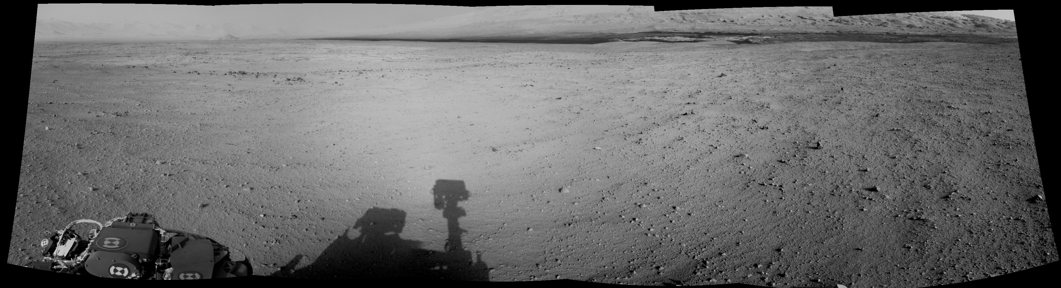 I had to be a little bit more stronger with processing, in order to retrieve a much better imagery. -------------------- |
|
|
|
|
Sep 18 2012, 06:16 PM
Post
#86
|
||
|
Solar System Cartographer Group: Members Posts: 10180 Joined: 5-April 05 From: Canada Member No.: 227 |
... and the previous nice pan by Ant103 reprojected.
Phil
-------------------- ... because the Solar System ain't gonna map itself.
Also to be found posting similar content on https://mastodon.social/@PhilStooke Maps for download (free PD: https://upload.wikimedia.org/wikipedia/comm...Cartography.pdf NOTE: everything created by me which I post on UMSF is considered to be in the public domain (NOT CC, public domain) |
|
|
|
|
|
|
Sep 18 2012, 06:32 PM
Post
#87
|
||
|
Member Group: Members Posts: 276 Joined: 11-December 07 From: Dar es Salaam, Tanzania Member No.: 3978 |
Seeing the navigation images are coming down in sets of 5 showing the same view for the past few sols, I tried stitching them all up and put together a (rough) animation to see our progress from the ground.
It is rather small so apologies for that. The full version will be on my blog in time. -------------------- |
|
|
|
|
|
|
Sep 18 2012, 07:38 PM
Post
#88
|
|
|
Member Group: Members Posts: 813 Joined: 29-December 05 From: NE Oh, USA Member No.: 627 |
http://www.nasa.gov/news/media/newsaudio/index.html NASA Hosts Teleconference About Mars Curiosity Rover Progress Wednesday, Sept. 19 at 2 p.m. EDT NASA will host a media teleconference to provide a status update on the Curiosity rover's mission to Mars' Gale Crater. Curiosity, the Mars Science Laboratory, is 43 days into a two-year mission to investigate whether conditions may have been favorable for microbial life. For teleconference dial-in information, reporters must send their name, media affiliation and telephone number to Elena Mejia at elena.mejia@jpl.nasa.gov or call NASA's Jet Propulsion Laboratory Media Relations Office at 818-354-5011. Note: A UStream player with audio of the briefing will appear here shortly before the event. Visuals supporting the briefing are/will be available at http://go.nasa.gov/curiositytelecon. |
|
|
|
|
Sep 19 2012, 05:42 AM
Post
#89
|
|
|
Member Group: Members Posts: 139 Joined: 14-October 05 From: Toronto, Canada Member No.: 529 |
JPL has been posting updates on the MSL project page.
http://mars.jpl.nasa.gov/msl/news/whatsnew/... What is interesting is that on September 17th, the use of DAN was part of the regular drive sequence. QUOTE On Sol 41, Curiosity logged 89 feet (27 meters), across the surface of Gale Crater. During this sol, for the first time, the DAN instrument (the Dynamic Albedo of Neutrons investigation) was incorporated into the rover's drive sequence.
-------------------- -- Robin
|
|
|
|
|
Sep 19 2012, 02:09 PM
Post
#90
|
|
|
Member Group: Admin Posts: 976 Joined: 29-September 06 From: Pasadena, CA - USA Member No.: 1200 |
We have been doinc DAN observations while driving for the past three drives already. Two observations on each drive.
Paolo -------------------- Disclaimer: all opinions, ideas and information included here are my own,and should not be intended to represent opinion or policy of my employer.
|
|
|
|
|

|
Lo-Fi Version | Time is now: 3rd June 2024 - 03:22 AM |
|
RULES AND GUIDELINES Please read the Forum Rules and Guidelines before posting. IMAGE COPYRIGHT |
OPINIONS AND MODERATION Opinions expressed on UnmannedSpaceflight.com are those of the individual posters and do not necessarily reflect the opinions of UnmannedSpaceflight.com or The Planetary Society. The all-volunteer UnmannedSpaceflight.com moderation team is wholly independent of The Planetary Society. The Planetary Society has no influence over decisions made by the UnmannedSpaceflight.com moderators. |
SUPPORT THE FORUM Unmannedspaceflight.com is funded by the Planetary Society. Please consider supporting our work and many other projects by donating to the Society or becoming a member. |
|