Journey to Mt Sharp - Part 1: Site 7 to Waypoint 1, Sol324 [Jul4,'13] to Sol391 [Sep12,'13] |

  |
Journey to Mt Sharp - Part 1: Site 7 to Waypoint 1, Sol324 [Jul4,'13] to Sol391 [Sep12,'13] |
 Aug 31 2013, 11:01 PM Aug 31 2013, 11:01 PM
Post
#466
|
|
|
Senior Member  Group: Members Posts: 2346 Joined: 7-December 12 Member No.: 6780 |
|
 |
 
|
|
Sep 1 2013, 01:01 AM
Post
#467
|
|
 Senior Member Group: Members Posts: 3419 Joined: 9-February 04 From: Minneapolis, MN, USA Member No.: 15 |
QUOTE (Gerald @ Aug 31 2013, 05:29 PM)  A Sol 379 x-eyed NavCam B stereo... Thanks, Gerald! That far rim wall is just incredible in 3D -- reminds me of seeing the rise of the Rockies emerging from the horizon as you drive west through Kansas. As impressive as these views are, I'm really looking forward to the panorama we will see from the side of Mt. Sharp of the Gale floor fading into the haze and, in the distance, the rim wall rearing up to enclose and overlook it all. I'm betting the rim wall is far clearer once we gain some altitude, and that the haze will appear to almost hug the ground below. We saw something of that effect from Spirit when she was atop Husband Hill, but I'm thinking the effect is going to be even more impressive from high on Mt. Sharp's flanks in another 18 to 24 months. -the other Doug -------------------- The trouble ain't that there is too many fools, but that the lightning ain't distributed right. -Mark Twain
|
|
|
|
|
Sep 1 2013, 03:30 AM
Post
#468
|
|
 Senior Member Group: Members Posts: 4250 Joined: 17-January 05 Member No.: 152 |
The rim will also become more visible as we head towards southern winter. Tau typically bottoms out a couple of months after the winter equinox (the equinox is Feb 15th 2014).
The view of the rim is already improving. I can't wait for this winter! |
|
|
|
|
Sep 1 2013, 04:57 PM
Post
#469
|
||
 Senior Member Group: Members Posts: 1465 Joined: 9-February 04 From: Columbus OH USA Member No.: 13 |
An MR mosaic from sol 343:
-------------------- |
|
|
|
|
|
|
Sep 1 2013, 06:22 PM
Post
#470
|
|
 Member Group: Members Posts: 222 Joined: 7-August 12 From: Garberville, CA Member No.: 6500 |
Going Even Deeper on Mt. Sharp... (oh my!)
The morning sun angle from the Sol 364 MC 34 panorama of Mt. Sharp was finally repeated with the Sol 375 pano making for some dramatic detail for another deep stereo dive into Mt. Sharp, and an unusually immersive one at that! Some of the Sol 375 images are still out as of this post so here's a preview of just the right side of the mountain from matching frames that are in. The baseline differential is approximately 300 meters. Will knock out the full mountain when additional frames are in. Default Anaglyph:  Detail Enhanced Anaglyph:  A Cross-Eye Version Cropped & Slightly Enhanced... cross-eye example of what combining any matching frames of Mt. Sharp from the Sol 364 & 375 panos can achieve for those without anaglyph glasses (just place the Sol 364 shots on the right side). Yeah baby.  Edit: Full Mt. Sharp version now posted here. -------------------- "We shall not cease from exploration, and the end of all our exploring will be to arrive where we started and know the place for the first time." -T.S. Eliot
|
|
|
|
|
Sep 1 2013, 06:33 PM
Post
#471
|
|
 Member Group: Members Posts: 811 Joined: 3-June 04 From: Brittany, France Member No.: 79 |
Thank you Ed, amazing feeling of depth !
-------------------- |
|
|
|
|
Sep 1 2013, 07:29 PM
Post
#472
|
|
|
Member Group: Members Posts: 222 Joined: 7-August 12 From: Garberville, CA Member No.: 6500 |
Sol 378 - Navcam 360's...
2-D (full frame):  Anaglyph (bottom cropped): 
-------------------- "We shall not cease from exploration, and the end of all our exploring will be to arrive where we started and know the place for the first time." -T.S. Eliot
|
|
|
|
|
Sep 2 2013, 12:58 AM
Post
#473
|
||
|
Solar System Cartographer Group: Members Posts: 10182 Joined: 5-April 05 From: Canada Member No.: 227 |
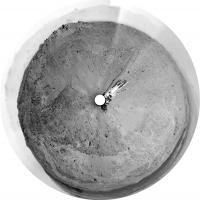
This is edtruthan's nice panorama in a circular format. The craters and other depressions show up quite well.
Phil
-------------------- ... because the Solar System ain't gonna map itself.
Also to be found posting similar content on https://mastodon.social/@PhilStooke Maps for download (free PD: https://upload.wikimedia.org/wikipedia/comm...Cartography.pdf NOTE: everything created by me which I post on UMSF is considered to be in the public domain (NOT CC, public domain) |
|
|
|
|
|
|
Sep 2 2013, 05:59 AM
Post
#474
|
|
 Senior Member Group: Members Posts: 2492 Joined: 15-January 05 From: center Italy Member No.: 150 |
QUOTE (jmknapp @ Sep 2 2013, 12:05 AM) --- Based on the pointing (267.42° (W), elevation 41.99°) & consulting Stellarium, Jupiter would have been in the frame of this one. About pictures pointing, Joe, I do not see this information on last images (Sol380/381) on http://curiosityrover.com/ . It is only matter of time or what else? -------------------- I always think before posting! - Marco -
|
|
|
|
|
Sep 2 2013, 10:06 AM
Post
#475
|
|
|
Senior Member Group: Members Posts: 1465 Joined: 9-February 04 From: Columbus OH USA Member No.: 13 |
It's just the timing--the most recent images often don't have updated SPICE info yet, Usually it shows up 12 hours or less from when the images are taken. Sometimes there's a longer delay.
-------------------- |
|
|
|
|
Sep 2 2013, 10:52 AM
Post
#476
|
|
|
Senior Member Group: Members Posts: 2492 Joined: 15-January 05 From: center Italy Member No.: 150 |
In fact, now it's OK. Thanks!
-------------------- I always think before posting! - Marco -
|
|
|
|
|
Sep 2 2013, 11:04 PM
Post
#477
|
|
|
Member Group: Members Posts: 222 Joined: 7-August 12 From: Garberville, CA Member No.: 6500 |
Mt. Sharp - Full Res Anaglyph - 14,800 x 1,200 pixels
This is probably the best I've seen of the upper mountain yet in 3-D. Sky's are reasonably clear, the separation baseline is good and wide, and the almost identical angle of morning light between sols adds lots of nice contrasts. (Would love to have an MC 100 pairing of this kind sometime.)  Left Channel: MC 34 , Sol 364 Right Channel: MC 34, Sol 375 Separation Baseline: Approx. 300 Meters -------------------- "We shall not cease from exploration, and the end of all our exploring will be to arrive where we started and know the place for the first time." -T.S. Eliot
|
|
|
|
|
Sep 3 2013, 11:03 PM
Post
#478
|
|
|
Senior Member Group: Members Posts: 1465 Joined: 9-February 04 From: Columbus OH USA Member No.: 13 |
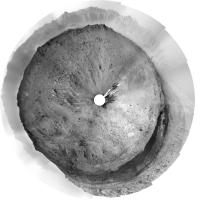
Sol 383, 42 meter drive
-------------------- |
|
|
|
|
Sep 4 2013, 02:02 PM
Post
#479
|
||
|
Solar System Cartographer Group: Members Posts: 10182 Joined: 5-April 05 From: Canada Member No.: 227 |
SFJCody: if your paper was different from jmknapp's, maybe you could provide a link for it?
Here's a circular version of the 383 post-drive pan, with a nice low sun angle showing topography nicely. I'll leave panorama experts to make a better cylindrical pan. Phil
-------------------- ... because the Solar System ain't gonna map itself.
Also to be found posting similar content on https://mastodon.social/@PhilStooke Maps for download (free PD: https://upload.wikimedia.org/wikipedia/comm...Cartography.pdf NOTE: everything created by me which I post on UMSF is considered to be in the public domain (NOT CC, public domain) |
|
|
|
|
|
|
Sep 4 2013, 07:28 PM
Post
#480
|
|
|
Member Group: Members Posts: 222 Joined: 7-August 12 From: Garberville, CA Member No.: 6500 |
Sol 383 - Navcam 360's...
2-D (full frame NRB)...  Anaglyph (bottom cropped)...  This was a challenging set of images. The low sun angle is really great to see, but recovering the detail from the extremely dark sun facing frames was tricky without completely washing out the crater rim. Hopefully these strike a decent balance. -------------------- "We shall not cease from exploration, and the end of all our exploring will be to arrive where we started and know the place for the first time." -T.S. Eliot
|
|
|
|
|

|
Lo-Fi Version | Time is now: 3rd June 2024 - 10:05 PM |
|
RULES AND GUIDELINES Please read the Forum Rules and Guidelines before posting. IMAGE COPYRIGHT |
OPINIONS AND MODERATION Opinions expressed on UnmannedSpaceflight.com are those of the individual posters and do not necessarily reflect the opinions of UnmannedSpaceflight.com or The Planetary Society. The all-volunteer UnmannedSpaceflight.com moderation team is wholly independent of The Planetary Society. The Planetary Society has no influence over decisions made by the UnmannedSpaceflight.com moderators. |
SUPPORT THE FORUM Unmannedspaceflight.com is funded by the Planetary Society. Please consider supporting our work and many other projects by donating to the Society or becoming a member. |
|