Targets for LRO |

  |
Targets for LRO |
 Apr 10 2007, 08:35 AM Apr 10 2007, 08:35 AM
Post
#16
|
|
|
Junior Member  Group: Members Posts: 23 Joined: 29-November 05 From: france Member No.: 591 |
I vote for Ina, too.
|
 |
 
|
|
Apr 10 2007, 04:58 PM
Post
#17
|
|
|
Member Group: Members Posts: 169 Joined: 17-March 06 Member No.: 709 |
Another LRO candidate would be the landing sites of Luna 18/Luna 20 and
Luna 23/Luna 24. Each of these Luna craft were sample-return missions. I put those together as pairs since, according to landing site coordinates, each lander in that pair is within a few miles of the other. This occurred because the 1st spacecraft in each pair never launched its Earth-return capsule, for one reason or another,while the 2nd one did succeed. Apparently, the Soviets just reflew the 2nd one using the same nav software as for the 1st? With LRO photos, we will be able to inspect the terrain around each lander, perhaps giving clues why Luna 18 and 23 did not function correctly. Also, it will be nice to see the specfic geologic context for each lander, since, as I recall, landing site imagery was not returned even by the successful "scoopers." (Did some of them land at night?) One more site of great interest would be the landing site for Luna 15. As far as I can tell, the Soviets never gave a really clear explanation of what happened to Luna 15. Was it descending too quickly? Was it damaged while landing? Was it like Surveyor 4 - an abrupt loss of signal while still several hundred, or several thousand, feet above the surface? Photos of Luna 15's landing site may tell us a lot. Another Phil |
|
|
|
|
Apr 10 2007, 06:04 PM
Post
#18
|
|
|
Solar System Cartographer Group: Members Posts: 10190 Joined: 5-April 05 From: Canada Member No.: 227 |
Luna 16 landed at night carrying cameras and artificial lighting. The lights failed. The images were transmitted, showing a landscape weakly lit by earthlight - very poorly exposed. Those images have never been released, but I think modern image processing methods would be able to get useful images from them if the original data tapes could be found in the state archives.
Luna 20 landed in daylight, and its images have been published in part (I think you can find them among these threads). Then the lander was redesigned and Lunas 23 and 24 did not carry cameras. Phil -------------------- ... because the Solar System ain't gonna map itself.
Also to be found posting similar content on https://mastodon.social/@PhilStooke Maps for download (free PD: https://upload.wikimedia.org/wikipedia/comm...Cartography.pdf NOTE: everything created by me which I post on UMSF is considered to be in the public domain (NOT CC, public domain) |
|
|
|
|
Apr 12 2007, 08:24 AM
Post
#19
|
|
 Member Group: Members Posts: 124 Joined: 23-March 06 Member No.: 723 |
I would like to see it image the rover tracks - Apollo's lunar rovers, Soviet Lunokhods.
|
|
|
|
|
Apr 14 2007, 05:34 AM
Post
#20
|
|
|
Junior Member Group: Members Posts: 94 Joined: 22-March 06 Member No.: 722 |
I have a soft spot for old Tycho; I'd love to see the kind of rugged landforms in that young crater that have been muted in older regions of the Moon (jagged mountains, hint-hint).

-------------------- Mayor: Er, Master Betty, what is the Evil Council's plan?
Master Betty: Nyah. Haha. It is EVIL, it is so EVIL. It is a bad, bad plan, which will hurt many... people... who are good. I think it's great that it's so bad. -Kung Pow: Enter the Fist |
|
|
|
|
Apr 14 2007, 01:31 PM
Post
#21
|
|
 Senior Member Group: Members Posts: 3419 Joined: 9-February 04 From: Minneapolis, MN, USA Member No.: 15 |
The problem is, the Moon doesn't really have any jagged peaks. Even around Tycho. Take a look at the pans from Surveyor VII -- even that close to Tycho's rim, the landforms are *still* all softened and rounded-looking.
-the other Doug -------------------- The trouble ain't that there is too many fools, but that the lightning ain't distributed right. -Mark Twain
|
|
|
|
|
Apr 14 2007, 08:55 PM
Post
#22
|
|
|
Rover Driver Group: Members Posts: 1015 Joined: 4-March 04 Member No.: 47 |
why is that? why is the moon so smooth? there's not much erosion....
|
|
|
|
|
Apr 14 2007, 09:34 PM
Post
#23
|
|
|
Solar System Cartographer Group: Members Posts: 10190 Joined: 5-April 05 From: Canada Member No.: 227 |
That's not really true. The surface is constantly subjected to micrometeorite sandblasting and mini-meteorite 'gardening' - processes which don't affect Mars, for instance. Slow, but acting over very long periods.
On top of that, because almost every feature, and every recent feature, is impact-generated, it's covered with or consists largely of unconsolidated rubble. Tycho's central peaks, for instance, though uplifted crust, must be badly shattered and partly covered with fall-back ejecta. The Apennines at Hadley, ditto. So they will tend to assume angle-of-repose type slopes from the start. And to add to the effect, every mid-sized or larger impact creates a seismic event which further subdues all that loose rubble. Not only that - I would suggest that most steep slopes on Earth are created by erosion. Lack of erosion on other worlds reduces opportunities for steep topography. -------------------- ... because the Solar System ain't gonna map itself.
Also to be found posting similar content on https://mastodon.social/@PhilStooke Maps for download (free PD: https://upload.wikimedia.org/wikipedia/comm...Cartography.pdf NOTE: everything created by me which I post on UMSF is considered to be in the public domain (NOT CC, public domain) |
|
|
|
|
Apr 14 2007, 11:03 PM
Post
#24
|
||
|
Solar System Cartographer Group: Members Posts: 10190 Joined: 5-April 05 From: Canada Member No.: 227 |
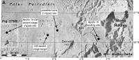
This shows the area. - duh! - referred to in the Apollo 15 thread. Sorry!
Phil
-------------------- ... because the Solar System ain't gonna map itself.
Also to be found posting similar content on https://mastodon.social/@PhilStooke Maps for download (free PD: https://upload.wikimedia.org/wikipedia/comm...Cartography.pdf NOTE: everything created by me which I post on UMSF is considered to be in the public domain (NOT CC, public domain) |
|
|
|
|
|
|
Apr 14 2007, 11:05 PM
Post
#25
|
|
|
Member Group: Members Posts: 234 Joined: 8-May 05 Member No.: 381 |
The ultrastrange swirls of Reiner Gamma get my vote for LRO targeting. I'd like to see all of the LRO instruments used to study this, including the highest resolution images we can get. If it was formed by a comet impact, there may still be volatiles embedded in the lunar soil leaking back into space, so the UV spectrometer might yield the most useful information. Too bad LRO has nothing to study the Reiner Gamma magnetic anomaly with.
|
|
|
|
|
Apr 18 2007, 02:53 PM
Post
#26
|
|
|
Member Group: Members Posts: 169 Joined: 17-March 06 Member No.: 709 |
I would like to see LRO get high-res images of Copernicus' central peak.
Here is a link to a LPOD discussion of Lunar Orbiter 2's famous photo of that crater. This is the LPOD for January 10, 2004 - http://www.lpod.org/archive/archive/2004/0...-2004-01-10.htm If you look closely, then you will see a thin dark line crossing one of Copernicus' central peaks. This is thought to be a geologic intrusion called a dike. However, LO2's image is just not sharp enough to be definitive on that call. LRO could help resolve what type of geologic layering is actually present in those central peaks. If you read Chuck Wood's description of that image, then you will notice that he mentions that the middle peak seems to be split. I think that he is referring to the one that has the possible dike. However, if it is split, then LRO's high-res images should reveal a gold mine of info into the history of this area. As any geologist knows, if you can see layering (as in Victoria Crater on Mars) then you can read the past in the rocks. Another Phil |
|
|
|
|
Apr 18 2007, 03:19 PM
Post
#27
|
|
|
Solar System Cartographer Group: Members Posts: 10190 Joined: 5-April 05 From: Canada Member No.: 227 |
Copernicus would be interesting, but Lunar Orbiter 5 also got very good images of the peaks. Check out:
http://astrogeology.usgs.gov/lo-cgi-bin//v...Name=Copernicus and other frames from: http://astrogeology.usgs.gov/Projects/Luna...s_veryhigh.html Not to say more would not be nice, especially for areas lost in shadow in LO5 images. Phil -------------------- ... because the Solar System ain't gonna map itself.
Also to be found posting similar content on https://mastodon.social/@PhilStooke Maps for download (free PD: https://upload.wikimedia.org/wikipedia/comm...Cartography.pdf NOTE: everything created by me which I post on UMSF is considered to be in the public domain (NOT CC, public domain) |
|
|
|
|
Jun 17 2009, 07:59 PM
Post
#28
|
|
|
Senior Member Group: Members Posts: 1074 Joined: 21-September 07 From: Québec, Canada Member No.: 3908 |
Resurrecting an old thread here.
You can view LRO's LROC targets on the following page: http://target.lroc.asu.edu/output/lroc/lroc_page.html You can even propose your own favorite target. (I seem to remember someone posting a map of LROC targets somewhere, but I can't find it anymore. Unless I saw that on another website. Sorry if I am duplicating a previous post.) |
|
|
|
|
Jun 18 2009, 11:00 AM
Post
#29
|
|
|
Solar System Cartographer Group: Members Posts: 10190 Joined: 5-April 05 From: Canada Member No.: 227 |
The maps are here, half way down the page. And they were an LPOD. Also check out the Constellation targets (just above the maps, two PDFs)
Phil http://ser.sese.asu.edu/LSM/targeting.php -------------------- ... because the Solar System ain't gonna map itself.
Also to be found posting similar content on https://mastodon.social/@PhilStooke Maps for download (free PD: https://upload.wikimedia.org/wikipedia/comm...Cartography.pdf NOTE: everything created by me which I post on UMSF is considered to be in the public domain (NOT CC, public domain) |
|
|
|
|
Jun 18 2009, 02:03 PM
Post
#30
|
|
|
Member Group: Members Posts: 279 Joined: 19-August 07 Member No.: 3299 |
Thanks Phil for the fantastic link.
|
|
|
|
|

|
Lo-Fi Version | Time is now: 8th June 2024 - 07:47 AM |
|
RULES AND GUIDELINES Please read the Forum Rules and Guidelines before posting. IMAGE COPYRIGHT |
OPINIONS AND MODERATION Opinions expressed on UnmannedSpaceflight.com are those of the individual posters and do not necessarily reflect the opinions of UnmannedSpaceflight.com or The Planetary Society. The all-volunteer UnmannedSpaceflight.com moderation team is wholly independent of The Planetary Society. The Planetary Society has no influence over decisions made by the UnmannedSpaceflight.com moderators. |
SUPPORT THE FORUM Unmannedspaceflight.com is funded by the Planetary Society. Please consider supporting our work and many other projects by donating to the Society or becoming a member. |
|