To the Cape! (part 2), For real this time! |

  |
To the Cape! (part 2), For real this time! |
 Jun 13 2008, 08:10 AM Jun 13 2008, 08:10 AM
Post
#1
|
||
|
Senior Member  Group: Moderator Posts: 4279 Joined: 19-April 05 From: .br at .es Member No.: 253 |
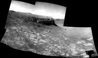
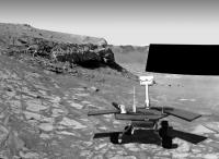
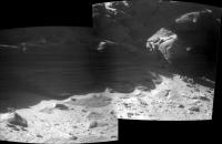
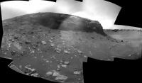
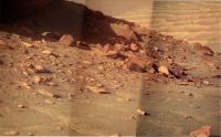
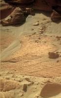
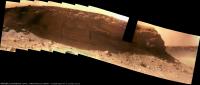
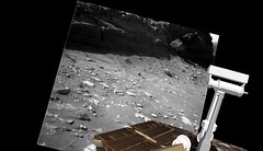
This is a navcam mosaic taken after driving during sol 1559.
Mmm, remember the name of this thread? To the Cape! Yeah! 
|
|
 |
 
|
|
|
Jun 13 2008, 10:38 AM
Post
#2
|
|
|
Forum Contributor Group: Members Posts: 1372 Joined: 8-February 04 From: North East Florida, USA. Member No.: 11 |
They are nice pictures. Makes a change to see something new after so many months.
|
|
|
|
|
Jun 13 2008, 03:16 PM
Post
#3
|
||
 Senior Member Group: Members Posts: 4247 Joined: 17-January 05 Member No.: 152 |
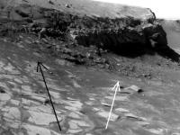
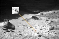
It's great to see us thoroughly out of the Quackmire! We now have a good view of potential approaches to Verde. Here's a crop from Tesheiner's mosaic. I've sketched two approaches that appear to stay pretty well on solid rocky surfaces. The black gets us close to the cliff, but not very deep - we've studied those layers already. The white route gets us deeper but not very close to the cliff. Of course they could continue past the end of the white arrow (that's where the original target lies), at the risk of getting bogged down again in loose soil...
|
|
|
|
|
|
|
Jun 13 2008, 08:56 PM
Post
#4
|
|
|
Senior Member Group: Moderator Posts: 4279 Joined: 19-April 05 From: .br at .es Member No.: 253 |
Before the, mmm, "event", I thought Opportunity would move to a point that is after the white arrow. I think the terrain at that point is traversable enough to get the rover touching the wall.
BUT the situation now has changed. At least two new issues. imo. The first is obviously the fact(?) that moving up to the wall would mean getting stuck again on the way back. The second is that after this long time the shadows are getting bigger at Cape Verde. |
|
|
|
|
Jun 13 2008, 11:24 PM
Post
#5
|
|
 Senior Member Group: Members Posts: 1887 Joined: 20-November 04 From: Iowa Member No.: 110 |
Winter Solstice occurs in the southern hemisphere of Mars on June 26 so the shadows will soon start getting shorter.
|
|
|
|
|
Jun 16 2008, 09:43 AM
Post
#6
|
|||
|
Senior Member Group: Moderator Posts: 4279 Joined: 19-April 05 From: .br at .es Member No.: 253 |
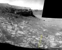
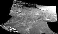
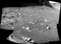
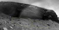
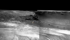
Neither the black not the white path, Opportunity has followed the "yellow bricks".
Here's the current position plotted on the navcam mosaic from sol 1559.
And the latest view from tosol (1562).
|
||
|
|
|
||
|
Jun 17 2008, 06:56 AM
Post
#7
|
||
 Senior Member Group: Admin Posts: 3108 Joined: 21-December 05 From: Canberra, Australia Member No.: 615 |
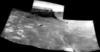
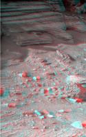
A lo-res SFX view based on Tesheiner's positioning.
Steady as she goes girl 
|
|
|
|
|
|
|
Jun 17 2008, 07:50 AM
Post
#8
|
|
|
Member Group: Members Posts: 877 Joined: 7-March 05 From: Switzerland Member No.: 186 |
And overcomes sand traps again and chocks like this:
http://qt.exploratorium.edu/mars/opportuni...25P1815R0M1.JPG Guess the two moved rocks is the spot where Oppy's middle wheel went stuck. -------------------- |
|
|
|
|
Jun 17 2008, 10:11 AM
Post
#9
|
|
|
Senior Member Group: Moderator Posts: 4279 Joined: 19-April 05 From: .br at .es Member No.: 253 |
I was a bit afraid with the path they were taking now (the "yellow" one), but have a look to today's drive results and compare with yesterday images.
 Sol 1562 -> Sol 1563 Sol 1562 -> Sol 1563  They moved Opportunity downhill over the sand up to the isolated slab seen on the images then back uphill almost to the same spot as before. Looking to the wheel marks I fell that the terrain is much more stable then on the previous path where she got stuck. |
|
|
|
|
Jun 17 2008, 11:21 AM
Post
#10
|
|
|
Senior Member Group: Members Posts: 2922 Joined: 14-February 06 From: Very close to the Pyrénées Mountains (France) Member No.: 682 |
You may say that it's easy to say it now, but it seams they are driving the way I thought they will.
Rove straight down, back-up to be sure you can (back-up), and so on. Once they are perpendicular and deaper to the place they want to meet the cliffs, they will do a ~80° + ~80° or so left turns and go up to the cliffs. Doing this, in case of been stuck, the'll can back up going down (on the same path) which will probably be much easier to get free. Any objection to this ? -------------------- |
|
|
|
|
Jun 17 2008, 02:14 PM
Post
#11
|
||
 The Poet Dude Group: Moderator Posts: 5551 Joined: 15-March 04 From: Kendal, Cumbria, UK Member No.: 60 |
Nice view...
-------------------- |
|
|
|
|
|
|
Jun 17 2008, 02:53 PM
Post
#12
|
|
|
Senior Member Group: Members Posts: 4247 Joined: 17-January 05 Member No.: 152 |
QUOTE (Tesheiner @ Jun 17 2008, 10:11 AM)  Looking to the wheel marks I fell that the terrain is much more stable then on the previous path where she got stuck. It does look like a successful toe-dip. After the quackmire, I'm still concerned about the sandy surface farther down. I wonder if they've been able to identify something about the appearance of the quackmire surface before we drove onto it that indicated it was dangerous. Or are they just trying again and hoping for the best... Climber, it seems to me it's got to be risky to drive deeper than we need to... |
|
|
|
|
Jun 18 2008, 12:38 AM
Post
#13
|
|
 Senior Member Group: Moderator Posts: 3431 Joined: 11-August 04 From: USA Member No.: 98 |
QUOTE (Astro0 @ Jun 17 2008, 12:56 AM) A lo-res SFX view based on Tesheiner's positioning. That looks about right, Astro0. I was digging around in MMB for some views from other perspectives and found this one. The position based on the tracking data is only approximate, but actually it looks about right to me: 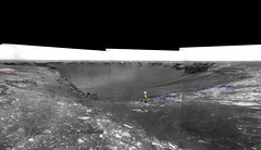
|
|
|
|
|
Jun 18 2008, 10:17 AM
Post
#14
|
||
|
Senior Member Group: Moderator Posts: 4279 Joined: 19-April 05 From: .br at .es Member No.: 253 |
We are getting closer!
This is from today's drive (sol 1564):
|
|
|
|
|
|
|
Jun 18 2008, 02:56 PM
Post
#15
|
|
|
Senior Member Group: Members Posts: 4247 Joined: 17-January 05 Member No.: 152 |
And the maneuvering at the end of the drive shows we've still got good traction:
http://qt.exploratorium.edu/mars/opportuni...74P1312R0M1.JPG |
|
|
|
|
Jun 19 2008, 03:32 PM
Post
#16
|
||
|
Senior Member Group: Members Posts: 4247 Joined: 17-January 05 Member No.: 152 |
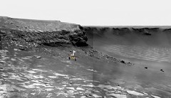
Another big drive downslope tosol (1565). The navcam view of Verde is now reminiscent of the previous best pancam views!
If we can make it across the scattered rocks immediately in front of us, it looks like a good, drivable rocky surface at the base of the cliff... We're now by far at the deepest point we've ever been on this mission. I wonder if these rock slabs that we're sitting on are original to this depth or tumbled down long ago. |
|
|
|
|
|
|
Jun 19 2008, 04:45 PM
Post
#17
|
|
|
Senior Member Group: Members Posts: 2922 Joined: 14-February 06 From: Very close to the Pyrénées Mountains (France) Member No.: 682 |
We're gonna need your "man in black" for scale, Fredk !
-------------------- |
|
|
|
|
Jun 19 2008, 09:02 PM
Post
#18
|
|
 Senior Member Group: Members Posts: 1281 Joined: 18-December 04 From: San Diego, CA Member No.: 124 |
Sweet Fancy Moses! So nice to be moving again!
-------------------- Lyford Rome
"Zis is not nuts, zis is super-nuts!" Mathematician Richard Courant on viewing an Orion test |
|
|
|
|
Jun 19 2008, 11:15 PM
Post
#19
|
|
|
Member Group: Members Posts: 139 Joined: 14-October 05 From: Toronto, Canada Member No.: 529 |
This cliff structure reminds me of sandstones I saw in Colorado that were the reminents of old sand dunes.
-------------------- -- Robin
|
|
|
|
|
Jun 20 2008, 08:47 AM
Post
#20
|
|
 Member Group: Members Posts: 593 Joined: 20-April 05 Member No.: 279 |
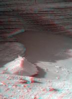
Assuming the range is 16m or so, and our fredk is around 1.8m, I'd say something like this:
 Andy |
|
|
|
|
Jun 20 2008, 09:20 AM
Post
#21
|
|
|
Senior Member Group: Members Posts: 3516 Joined: 4-November 05 From: North Wales Member No.: 542 |
Looks like the perfect spot for another picnic.
|
|
|
|
|
Jun 20 2008, 09:37 AM
Post
#22
|
||
 Member Group: Members Posts: 568 Joined: 20-April 05 From: Silesia Member No.: 299 |
QUOTE (ngunn @ Jun 20 2008, 09:20 AM) Looks like the perfect spot for another picnic. But it's very dangerous place. We can find missing Miranda, Irma and Marion.
-------------------- Free software for planetary science (including Cassini Image Viewer).
http://members.tripod.com/petermasek/marinerall.html |
|
|
|
|
|
|
Jun 20 2008, 09:58 AM
Post
#23
|
|
|
Member Group: Members Posts: 568 Joined: 20-April 05 From: Silesia Member No.: 299 |
We are very near.
http://qt.exploratorium.edu/mars/opportuni...ARP1211R0M1.JPG -------------------- Free software for planetary science (including Cassini Image Viewer).
http://members.tripod.com/petermasek/marinerall.html |
|
|
|
|
Jun 20 2008, 10:45 AM
Post
#24
|
|||
|
Senior Member Group: Moderator Posts: 4279 Joined: 19-April 05 From: .br at .es Member No.: 253 |
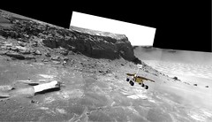
QUOTE (fredk @ Jun 19 2008, 05:32 PM) The navcam view of Verde is now reminiscent of the previous best pancam views! Now, look at THIS!!! 
http://nasa.exploratorium.edu/mars/opportu...cam/2008-06-20/ Edited: Just 10 meters up to the wall! QUOTE (ngunn @ Jun 20 2008, 11:20 AM) Looks like the perfect spot for another picnic. Agree. It's time for another UMSF BBQ! |
||
|
|
|
||
|
Jun 20 2008, 10:59 AM
Post
#25
|
|
 Senior Member Group: Moderator Posts: 2262 Joined: 9-February 04 From: Melbourne - Oz Member No.: 16 |
QUOTE (Tesheiner @ Jun 20 2008, 11:45 AM) Now, look at THIS!!! And that sequence is labelled as: pancam_drive_dir_L7R1 !!!  Amazing. I was thinking the same about this being a nice spot for lunch. James -------------------- |
|
|
|
|
Jun 20 2008, 12:45 PM
Post
#26
|
||
|
Member Group: Members Posts: 877 Joined: 7-March 05 From: Switzerland Member No.: 186 |
Looks like it's a popular place here - someone forgot his picnic basket

Attached thumbnail(s)
-------------------- |
|
|
|
|
|
|
Jun 20 2008, 01:08 PM
Post
#27
|
|
|
Senior Member Group: Moderator Posts: 3431 Joined: 11-August 04 From: USA Member No.: 98 |
A few frames from an imaginary movie "zooming in" on the present position:
|
|
|
|
|
Jun 20 2008, 01:59 PM
Post
#28
|
||
|
The Poet Dude Group: Moderator Posts: 5551 Joined: 15-March 04 From: Kendal, Cumbria, UK Member No.: 60 |
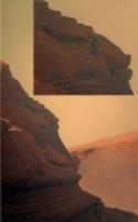
Yes! THIS is what we came all this way to see!
-------------------- |
|
|
|
|
|
|
Jun 20 2008, 03:15 PM
Post
#29
|
|
|
Senior Member Group: Members Posts: 1281 Joined: 18-December 04 From: San Diego, CA Member No.: 124 |
-------------------- Lyford Rome
"Zis is not nuts, zis is super-nuts!" Mathematician Richard Courant on viewing an Orion test |
|
|
|
|
Jun 21 2008, 08:43 AM
Post
#30
|
|
 Member Group: Members Posts: 276 Joined: 11-December 07 From: Dar es Salaam, Tanzania Member No.: 3978 |
I must say this is an impressive view of the Cape.(considering my pessimism for this drive)
However if they wish to get closer, i would recomend hard hats  Seriously, do we have to worry about falling rocks fro the cliff? 
-------------------- |
|
|
|
|
Jun 21 2008, 02:36 PM
Post
#31
|
|
|
Senior Member Group: Members Posts: 4247 Joined: 17-January 05 Member No.: 152 |
Do you folks remember this Victoria's wishlist thread? If we do get a bit closer we may get a cliff tiltorama afterall!
About falling rocks, we haven't seen anything come off any of the cliffs so far, but if she got close enough to do some grinding, who knows?
|
|
|
|
|
Jun 21 2008, 02:52 PM
Post
#32
|
|
 Senior Member Group: Admin Posts: 4763 Joined: 15-March 05 From: Glendale, AZ Member No.: 197 |
I am drooling at the prospect of seeing a nice clean RAT and MI of the lowest reachable layers.
I hope our skilled driver friends are back here on Earth practicing their ballet. -------------------- If Occam had heard my theory, things would be very different now.
|
|
|
|
|
Jun 21 2008, 11:25 PM
Post
#33
|
|
|
Senior Member Group: Admin Posts: 3108 Joined: 21-December 05 From: Canberra, Australia Member No.: 615 |
QUOTE (Tesheiner @ Jun 20 2008, 08:45 PM) Agree. It's time for another UMSF BBQ! Hmmm. Another BBQ. Yes, it has been some time. I was hoping to do one around now, but the images I have of all of you just don't fit and wouldn't it be nice to include all the new faces since the last one over at HomePlate. Perhaps this is something that we should discuss over at the Community Chit Chat thread. My thought would be to wait until we have the mother-of-all-panoramas in colour first however. Astro0 |
|
|
|
| Guest_Sunspot_* |
Jun 22 2008, 07:46 AM
Post
#34
|
|
Guests |
What happened to yesterdays downlink? Or did they give the rover a day off?
|
|
|
|
|
Jun 22 2008, 10:00 AM
Post
#35
|
|
|
Senior Member Group: Moderator Posts: 2262 Joined: 9-February 04 From: Melbourne - Oz Member No.: 16 |
No day off, there was a drive planned yesterday according to the tracking site.
I was waiting impatiently for data yesterday yesterday as well. But now we are so close to the cape the Odyssey passes are going to be a lot more restricted and I can imagine a few passes may be missed. Hoping to have my socks knocked off later today. James -------------------- |
|
|
|
|
Jun 22 2008, 12:37 PM
Post
#36
|
|
|
Member Group: Members Posts: 568 Joined: 20-April 05 From: Silesia Member No.: 299 |
No comment !
http://qt.exploratorium.edu/mars/opportuni...B0P1980L0M1.JPG http://qt.exploratorium.edu/mars/opportuni...B0P1982L0M1.JPG http://qt.exploratorium.edu/mars/opportuni...B0P1980L0M1.JPG -------------------- Free software for planetary science (including Cassini Image Viewer).
http://members.tripod.com/petermasek/marinerall.html |
|
|
|
|
Jun 22 2008, 12:48 PM
Post
#37
|
|
|
Merciless Robot Group: Admin Posts: 8784 Joined: 8-December 05 From: Los Angeles Member No.: 602 |
 ...well, there went my socks! ...well, there went my socks!
-------------------- A few will take this knowledge and use this power of a dream realized as a force for change, an impetus for further discovery to make less ancient dreams real.
|
|
|
|
|
Jun 22 2008, 12:49 PM
Post
#38
|
|
|
Senior Member Group: Moderator Posts: 2262 Joined: 9-February 04 From: Melbourne - Oz Member No.: 16 |
I think the front hazcam is my favourite
 http://qt.exploratorium.edu/mars/opportuni...B0P1211R0M1.JPG -------------------- |
|
|
|
|
Jun 22 2008, 12:50 PM
Post
#39
|
|
 Senior Member Group: Members Posts: 3648 Joined: 1-October 05 From: Croatia Member No.: 523 |
QUOTE (peter59 @ Jun 22 2008, 02:37 PM) No comment ! The second one is awesome, great contrast of light and dark! -------------------- |
|
|
|
|
Jun 22 2008, 01:41 PM
Post
#40
|
|
|
Member Group: Members Posts: 530 Joined: 21-March 06 From: Canada Member No.: 721 |
Looks like a "toe dip" onto the scree (if that's the right name for this stuff). Seems solid enough. How close are they planning to get?
Brian |
|
|
|
|
Jun 22 2008, 02:36 PM
Post
#41
|
||
|
Senior Member Group: Moderator Posts: 2262 Joined: 9-February 04 From: Melbourne - Oz Member No.: 16 |
Navcam Pan

-------------------- |
|
|
|
|
|
|
Jun 22 2008, 03:21 PM
Post
#42
|
|
|
Senior Member Group: Moderator Posts: 3431 Joined: 11-August 04 From: USA Member No.: 98 |
QUOTE (jamescanvin @ Jun 22 2008, 07:36 AM) Navcam Pan Funny, I was just doing the same thing. I don't think I've stitched anything in over a year. But since my stitch came out more or less the same (with one additional sky image), I'll offer this instead, and thanks to Doug hosting the file: QuickTime VR movie (2.1Mb). And I'll leave the stitching to James next time |
|
|
|
|
Jun 22 2008, 03:37 PM
Post
#43
|
|
|
Senior Member Group: Admin Posts: 4763 Joined: 15-March 05 From: Glendale, AZ Member No.: 197 |
QUOTE (mhoward @ Jun 22 2008, 07:21 AM) I'll offer this instead, and thanks to Doug hosting the file: QuickTime VR movie (2.1Mb). Dang! That is sweet, Mike. Could you please go back and do that for every other spot we've parked at on Mars?
-------------------- If Occam had heard my theory, things would be very different now.
|
|
|
|
|
Jun 22 2008, 05:19 PM
Post
#44
|
|
|
Senior Member Group: Moderator Posts: 4279 Joined: 19-April 05 From: .br at .es Member No.: 253 |
QUOTE (jamescanvin @ Jun 22 2008, 04:36 PM) Navcam Pan Did it too. What a view! If they stop at this spot (I would prefer to go up to the wall, but shadow and UHF coverage might be a problem) the pancam mosaic (360 degrees pleeeeeaaaaaaasssssseeee!!!!) will be a hell of a view. Edit: Just finished downloading Mike's VR shot, and I must agree with Dan. |
|
|
|
|
Jun 23 2008, 07:07 AM
Post
#45
|
|
 Member Group: Members Posts: 144 Joined: 17-July 07 From: Canberra Australia Member No.: 2865 |
Go Oppy! Take the limelight back from that 'Johnny come lately' at the pole.
|
|
|
|
|
Jun 23 2008, 12:07 PM
Post
#46
|
||
|
The Poet Dude Group: Moderator Posts: 5551 Joined: 15-March 04 From: Kendal, Cumbria, UK Member No.: 60 |
New pancam images are up...
http://qt.exploratorium.edu/mars/opportuni...ncam/2008-06-23 ...but boy, they're a mess! If you hate lens flare don't go and look, it's everywhere, obliterating detail on the cliffs... and I think there are a few "sunrise" images too but they're very small...
-------------------- |
|
|
|
|
|
|
Jun 23 2008, 12:43 PM
Post
#47
|
|
|
Senior Member Group: Members Posts: 2998 Joined: 30-October 04 Member No.: 105 |
What do you mean? The pancams of the cliff are exposed for the shadows, so the highlights are going to be overexposed, and with the dust-covered protective windows in sunlight, there is going to be a loss of contrast. Nothing that can't be processed out of the images.
Not optimum, but hardly a mess. http://qt.exploratorium.edu/mars/opportuni...00P2445L7M1.JPG http://qt.exploratorium.edu/mars/opportuni...00P2445L7M1.JPG -------------------- |
|
|
|
|
Jun 23 2008, 12:46 PM
Post
#48
|
|
|
The Poet Dude Group: Moderator Posts: 5551 Joined: 15-March 04 From: Kendal, Cumbria, UK Member No.: 60 |
Well, good luck "processing" something out of this...
http://qt.exploratorium.edu/mars/opportuni...00P2445L6M1.JPG and this... http://qt.exploratorium.edu/mars/opportuni...00P2445L5M1.JPG Ok, point taken... some, not all, are a mess.
-------------------- |
|
|
|
|
Jun 23 2008, 12:46 PM
Post
#49
|
|
 Member Group: Members Posts: 754 Joined: 9-February 07 Member No.: 1700 |
After four+ years, my jaw still hangs open at what we're getting from these rovers!
Great QT, mike! |
|
|
|
|
Jun 23 2008, 02:43 PM
Post
#50
|
|
|
Senior Member Group: Members Posts: 4247 Joined: 17-January 05 Member No.: 152 |
QUOTE (Stu @ Jun 23 2008, 12:07 PM) New pancam images are up... Just to be clear, the newest of the new batch of pancams are from sol 1562 (apart from the solar filter shots), when we were much farther from the cliff than we are now. They were experimenting with exposures to try bring out detail in the shadows, which lead to severe bleeding from the sunlit areas. I have to say, I actually thought some of these heavily-bleeded images looked kind of cool, like this one. |
|
|
|
|
Jun 23 2008, 03:00 PM
Post
#51
|
|
|
The Poet Dude Group: Moderator Posts: 5551 Joined: 15-March 04 From: Kendal, Cumbria, UK Member No.: 60 |
QUOTE (fredk @ Jun 23 2008, 03:43 PM) I have to say, I actually thought some of these heavily-bleeded images looked kind of cool, like this one. Oh god, I can see Certain People claiming these are martian stromatolites or vegetation or something, and were deliberately airbrushed out of photos taken later... -------------------- |
|
|
|
|
Jun 23 2008, 04:05 PM
Post
#52
|
|
 Member Group: Members Posts: 270 Joined: 29-December 04 From: NLA0: Member No.: 133 |
Three frame stitch:
http://paranoid.dechengst.nl/mars/are%20we...apa%20smurf.jpg (500 KB) Looks like we'll need HDR imaging to get good results overall. -------------------- PDP, VAX and Alpha fanatic ; HP-Compaq is the Satan! ; Let us pray daily while facing Maynard! ; Life starts at 150 km/h ;
|
|
|
|
|
Jun 24 2008, 12:24 AM
Post
#53
|
|
|
Senior Member Group: Moderator Posts: 3431 Joined: 11-August 04 From: USA Member No.: 98 |
Yeah that overexposed stuff is from sol 1562 (seven sols ago). A few images came down from sol 1569, but all sky. Looks like we need to be patient.
P.S. Thanks for the comments on the QTVR. All I actually did was was export the frames from MMB and load the .pts file into PTGui. Whole process took a few minutes. Okay, I adjusted the image brightnesses first, which took a little longer. |
|
|
|
|
Jun 24 2008, 06:58 AM
Post
#54
|
|
|
Member Group: Members Posts: 568 Joined: 20-April 05 From: Silesia Member No.: 299 |
I have great expectations.
Sol Seq.Ver ETH ESF EDN EFF ERP Tot Description ----- -------- --- --- --- --- --- ---- ----------- 01570 p2265.06 40 40 0 0 2 82 pancam_cape_verde_10pts_L257R2 -------------------- Free software for planetary science (including Cassini Image Viewer).
http://members.tripod.com/petermasek/marinerall.html |
|
|
|
|
Jun 24 2008, 02:39 PM
Post
#55
|
|
|
Senior Member Group: Members Posts: 4247 Joined: 17-January 05 Member No.: 152 |
One of the first closeup pancams, from sol 1570:
http://qt.exploratorium.edu/mars/opportuni...B0P2265L2M1.JPG Lot's more to come!
|
|
|
|
|
Jun 24 2008, 03:47 PM
Post
#56
|
|
|
Member Group: Members Posts: 270 Joined: 29-December 04 From: NLA0: Member No.: 133 |
I truly suck at color correction™:
http://paranoid.dechengst.nl/mars/Cape%20V...ee%20frames.jpg (570 KB) -------------------- PDP, VAX and Alpha fanatic ; HP-Compaq is the Satan! ; Let us pray daily while facing Maynard! ; Life starts at 150 km/h ;
|
|
|
|
|
Jun 24 2008, 07:16 PM
Post
#57
|
||
|
The Poet Dude Group: Moderator Posts: 5551 Joined: 15-March 04 From: Kendal, Cumbria, UK Member No.: 60 |
Rockhounds... prepare to go "Oooooooooooooooooohhhhhhhhhh!!!"
-------------------- |
|
|
|
|
|
|
Jun 24 2008, 07:26 PM
Post
#58
|
||
|
Member Group: Members Posts: 877 Joined: 7-March 05 From: Switzerland Member No.: 186 |
Nice contrast at ~14:40 LTST
Attached thumbnail(s)
-------------------- |
|
|
|
|
|
|
Jun 24 2008, 08:11 PM
Post
#59
|
||
|
The Poet Dude Group: Moderator Posts: 5551 Joined: 15-March 04 From: Kendal, Cumbria, UK Member No.: 60 |
Best I can do... others will do waay better, I know
-------------------- |
|
|
|
|
|
|
Jun 24 2008, 09:47 PM
Post
#60
|
||
|
The Poet Dude Group: Moderator Posts: 5551 Joined: 15-March 04 From: Kendal, Cumbria, UK Member No.: 60 |
... and I don't know about anyone else, but I'd be a bit worried about Oppy driving underneath something that looks this unstable...
-------------------- |
|
|
|
|
|
|
Jun 24 2008, 10:33 PM
Post
#61
|
|
|
Senior Member Group: Admin Posts: 4763 Joined: 15-March 05 From: Glendale, AZ Member No.: 197 |
QUOTE (Stu @ Jun 24 2008, 01:47 PM) ... and I don't know about anyone else, but I'd be a bit worried about Oppy driving underneath something that looks this unstable... Looking at that image I expect a coyote to come plumetting down on the rover and then an anvil to crash down on both of them. -------------------- If Occam had heard my theory, things would be very different now.
|
|
|
|
|
Jun 24 2008, 11:10 PM
Post
#62
|
|
|
Merciless Robot Group: Admin Posts: 8784 Joined: 8-December 05 From: Los Angeles Member No.: 602 |
Yes...it is never safe to underestimate the reach of the evil Acme Corporation and its fiendishly persistent (though clumsy) field representatives...
Good point, though. I have no clue how stable these cliffs are. Come to that, we really don't have much of a clue as to the frequency & intensity of martian seismic events, though IIRC V2 didn't find much at all (V1's seismometer was inop, unless I got that backwards). The motion of Oppy shouldn't be enough to trigger anything by itself, though considering such effects in 0.38g combined with an utterly dry outcrop is kind of difficult...are ancient evaporites all that's holding this thing together besides compression? -------------------- A few will take this knowledge and use this power of a dream realized as a force for change, an impetus for further discovery to make less ancient dreams real.
|
|
|
|
|
Jun 25 2008, 04:17 AM
Post
#63
|
|
 Senior Member Group: Members Posts: 3419 Joined: 9-February 04 From: Minneapolis, MN, USA Member No.: 15 |
QUOTE (nprev @ Jun 24 2008, 06:10 PM) Yes...it is never safe to underestimate the reach of the evil Acme Corporation and its fiendishly persistent (though clumsy) field representatives... Although, you do have to admit that Acme has a very consistent track record -- and that record is, to be frank, abysmal. Therefore, you'd expect the Acme Mars Lander Wile E. Coyote would have to have used would not have gotten Canis Coyotus safely to the surface, much less anywhere near our beloved Oppy... -the other Doug -------------------- The trouble ain't that there is too many fools, but that the lightning ain't distributed right. -Mark Twain
|
|
|
|
|
Jun 25 2008, 06:32 AM
Post
#64
|
|
|
Member Group: Members Posts: 568 Joined: 20-April 05 From: Silesia Member No.: 299 |
I was slightly disappointed yesterday, but I have greater expectations today.
Sol Seq.Ver ETH ESF EDN EFF ERP Tot Description ----- -------- --- --- --- --- --- ---- ----------- 01571 p2266.06 80 80 0 0 2 162 pancam_cape_verde_20pts_L257R2 -------------------- Free software for planetary science (including Cassini Image Viewer).
http://members.tripod.com/petermasek/marinerall.html |
|
|
|
|
Jun 25 2008, 12:54 PM
Post
#65
|
|||
|
The Poet Dude Group: Moderator Posts: 5551 Joined: 15-March 04 From: Kendal, Cumbria, UK Member No.: 60 |
Oh my...
-------------------- |
||
|
|
|
||
|
Jun 25 2008, 02:39 PM
Post
#66
|
|||
|
The Poet Dude Group: Moderator Posts: 5551 Joined: 15-March 04 From: Kendal, Cumbria, UK Member No.: 60 |
... and a couple more views before I head out to work... looking forward to seeing everyone else's efforts when I get back
-------------------- |
||
|
|
|
||
|
Jun 25 2008, 05:57 PM
Post
#67
|
|
|
Senior Member Group: Moderator Posts: 2262 Joined: 9-February 04 From: Melbourne - Oz Member No.: 16 |
Not much of tosols bit has come down, but most of yestersols has.
 (Click image) James -------------------- |
|
|
|
|
Jun 25 2008, 07:08 PM
Post
#68
|
|
|
Member Group: Members Posts: 206 Joined: 15-August 07 From: Shrewsbury, Shropshire Member No.: 3233 |
QUOTE (jamescanvin @ Jun 25 2008, 06:57 PM) Not much of tosols bit has come down, but most of yestersols has. James I am really impressed by both stu's and james canvin's views of the strata exposed on the face of Capo Verde. For the first time details can be seen in the shadows. Now the geologists can get to work describing these beds which I think are stratigraphically below the Gibson band that Oppy RATed a few months ago. Am I correct in thinking that I can see lenticular bedding or am I just imagining it? Am I correct in thinking that some of the rocks on the slope are in situ and are therefore representative of an even lower stratum? |
|
|
|
|
Jun 25 2008, 07:18 PM
Post
#69
|
|
|
Member Group: Members Posts: 128 Joined: 5-May 04 Member No.: 74 |
QUOTE (nprev @ Jun 24 2008, 07:10 PM) Yes...it is never safe to underestimate the reach of the evil Acme Corporation and its fiendishly persistent (though clumsy) field representatives... I always think of the Acme Corporation when I see the Maas joke video of the RAT going into the rock and the rover spinning around. "If the Acme Corporation had developed the MERs." |
|
|
|
|
Jun 25 2008, 08:16 PM
Post
#70
|
|
|
Senior Member Group: Admin Posts: 4763 Joined: 15-March 05 From: Glendale, AZ Member No.: 197 |
Has there been any attempt to correlate the layers in Victoria to the layers identified in Eagle and Endurance craters? Was there any effort to follow the sequence(s) and surface layers with the APXS and Mossbauer data as Opportunity moved South? As I recall there was some ratting and integrating underfoot throughout the trip and in the exposures in Erebus.
-------------------- If Occam had heard my theory, things would be very different now.
|
|
|
|
|
Jun 25 2008, 09:15 PM
Post
#71
|
|
|
Member Group: Members Posts: 235 Joined: 2-August 05 Member No.: 451 |
Opportunity's little Mossbauer unit must be pretty tired by now. It has a halflife of 3/4 year (roughly). So now, after about 8 half-lives, activity is down to a few parts per thousand of the initial strength.
|
|
|
|
|
Jun 26 2008, 03:28 AM
Post
#72
|
||
|
Senior Member Group: Moderator Posts: 4279 Joined: 19-April 05 From: .br at .es Member No.: 253 |
QUOTE (PaulM @ Jun 25 2008, 09:08 PM) Am I correct in thinking that some of the rocks on the slope are in situ and are therefore representative of an even lower stratum? There is a path in front of the rover which has a rocky ground almost at the base of the wall. That ground is layered, visible on both nav and pancams, and might be in situ.
|
|
|
|
|
|
|
Jun 26 2008, 03:10 PM
Post
#73
|
||
|
The Poet Dude Group: Moderator Posts: 5551 Joined: 15-March 04 From: Kendal, Cumbria, UK Member No.: 60 |
Hot off the press...
-------------------- |
|
|
|
|
|
|
Jun 26 2008, 03:18 PM
Post
#74
|
|
|
The Poet Dude Group: Moderator Posts: 5551 Joined: 15-March 04 From: Kendal, Cumbria, UK Member No.: 60 |
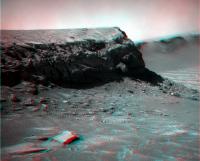
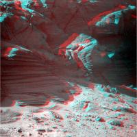
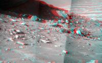
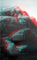
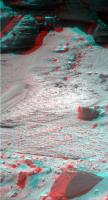
... and 3D view...
-------------------- |
|
|
|
|
Jun 26 2008, 03:20 PM
Post
#75
|
|
|
The Poet Dude Group: Moderator Posts: 5551 Joined: 15-March 04 From: Kendal, Cumbria, UK Member No.: 60 |
... and a bit of the floor, too... lots of rocks Oppy, be careful now...
We have GOT to get a closer look at the jagged rock bottom left on this image...
-------------------- |
|
|
|
|
Jun 26 2008, 03:34 PM
Post
#76
|
|
|
The Poet Dude Group: Moderator Posts: 5551 Joined: 15-March 04 From: Kendal, Cumbria, UK Member No.: 60 |
-------------------- |
|
|
|
|
Jun 26 2008, 08:22 PM
Post
#77
|
|
|
Senior Member Group: Moderator Posts: 2262 Joined: 9-February 04 From: Melbourne - Oz Member No.: 16 |
Today's offering.
 James -------------------- |
|
|
|
|
Jun 27 2008, 04:52 PM
Post
#78
|
||
|
Senior Member Group: Members Posts: 4247 Joined: 17-January 05 Member No.: 152 |
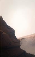
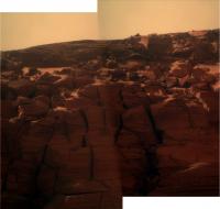
Another sol, another spectacular set of pancams - here's one of my favourite views, in 3D:
|
|
|
|
|
|
|
Jun 27 2008, 05:21 PM
Post
#79
|
||
|
Member Group: Members Posts: 568 Joined: 20-April 05 From: Silesia Member No.: 299 |
My favourite views:
http://qt.exploratorium.edu/mars/opportuni...B0P2266L2M1.JPG http://qt.exploratorium.edu/mars/opportuni...B0P2266R2M1.JPG Looks like frames from old science fiction movie (Star Trek).
-------------------- Free software for planetary science (including Cassini Image Viewer).
http://members.tripod.com/petermasek/marinerall.html |
|
|
|
|
|
|
Jun 27 2008, 06:14 PM
Post
#80
|
|
|
Senior Member Group: Moderator Posts: 2262 Joined: 9-February 04 From: Melbourne - Oz Member No.: 16 |
Just one image short of completing the sol 1570/1 bit now. It's becoming an amazing view!
Still this is only half of the total pan taken so far if you include those from sols 1572/3 that are still on the rover.  James -------------------- |
|
|
|
|
Jun 27 2008, 10:29 PM
Post
#81
|
||
 Senior Member Group: Members Posts: 2492 Joined: 15-January 05 From: center Italy Member No.: 150 |
Superb mosaic, James, even with dirt and unfilled rectangle...
Edit: Here I tried to reduce effects of dirt and glare in the half res version:
Attached thumbnail(s)
-------------------- I always think before posting! - Marco -
|
|
|
|
|
|
|
Jun 28 2008, 01:38 AM
Post
#82
|
|
 Member Group: Members Posts: 656 Joined: 20-April 05 From: League City, Texas Member No.: 285 |
QUOTE (peter59 @ Jun 27 2008, 11:21 AM) The discontinuity between the thick central unit and the lower unit is interesting. Those lower layers seem to be at a significantly different orientation than in the upper. |
|
|
|
|
Jun 28 2008, 02:01 AM
Post
#83
|
|
 Senior Member Group: Moderator Posts: 2785 Joined: 10-November 06 From: Pasadena, CA Member No.: 1345 |
QUOTE (algorimancer @ Jun 27 2008, 08:38 PM) The discontinuity between the thick central unit and the lower unit is interesting. Those lower layers seem to be at a significantly different orientation than in the upper. Very interesting observation! Anyone got a possible explanation? -------------------- Some higher resolution images available at my photostream: http://www.flickr.com/photos/31678681@N07/
|
|
|
|
|
Jun 28 2008, 02:10 AM
Post
#84
|
|
|
Merciless Robot Group: Admin Posts: 8784 Joined: 8-December 05 From: Los Angeles Member No.: 602 |
Mmm...differential weathering? I've seen apparent discontinuities like this in the past on Earth; maybe the prevailing wind path around the two vertically separated regions is just different enough to cause the disparity. (I'm assuming that the whole formation is old, old, old...)
-------------------- A few will take this knowledge and use this power of a dream realized as a force for change, an impetus for further discovery to make less ancient dreams real.
|
|
|
|
|
Jun 28 2008, 03:40 AM
Post
#85
|
|
|
Senior Member Group: Moderator Posts: 2785 Joined: 10-November 06 From: Pasadena, CA Member No.: 1345 |
I'm wondering if we are seeing deposition, tilting of strata, erosion of upper section of tilted strata, then redeposition of upper layers of strata.
That would imply the lower layers are old, AND had an interesting history prior to the deposition of the upper strata. -Mike -------------------- Some higher resolution images available at my photostream: http://www.flickr.com/photos/31678681@N07/
|
|
|
|
|
Jun 28 2008, 04:01 AM
Post
#86
|
|
|
Solar System Cartographer Group: Members Posts: 10173 Joined: 5-April 05 From: Canada Member No.: 227 |
No - much more likely to be just cross-bedding - i.e. cemented dune sandstones.
Phil -------------------- ... because the Solar System ain't gonna map itself.
Also to be found posting similar content on https://mastodon.social/@PhilStooke Maps for download (free PD: https://upload.wikimedia.org/wikipedia/comm...Cartography.pdf NOTE: everything created by me which I post on UMSF is considered to be in the public domain (NOT CC, public domain) |
|
|
|
|
Jun 28 2008, 04:23 AM
Post
#87
|
|
|
Senior Member Group: Moderator Posts: 2785 Joined: 10-November 06 From: Pasadena, CA Member No.: 1345 |
QUOTE (Phil Stooke @ Jun 27 2008, 11:01 PM) No - much more likely to be just cross-bedding - i.e. cemented dune sandstones. Phil I thought cross bedding had little "wedgie" shapes? -------------------- Some higher resolution images available at my photostream: http://www.flickr.com/photos/31678681@N07/
|
|
|
|
|
Jun 28 2008, 05:06 AM
Post
#88
|
|
|
Senior Member Group: Members Posts: 2998 Joined: 30-October 04 Member No.: 105 |
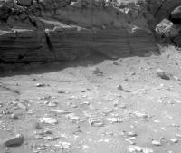
At first glance it looks like truncated cross-beds or an unconformity, which is consistent with the aeolian dune-playa setting. We've seen this at several places in Endurance and Victoria. But if you look closely at the lower beds, you can see a fabric of essentially horizontal beds, morte or less parallel to the upper beds. So I'm thinking that one or the other orientation of the lower bed may be an artifact of aeolian erosion. We need an up-close look. We'll also be able to tell more once Oppy starts taking images out of the flat (shadowed) light.
Of more interest is the open fracture in the upper beds. Is it a solution cavity, or what? Another example of the x-bedding is in 1P259578369EFF8900P2570L6M1. --Bill -------------------- |
|
|
|
|
Jun 28 2008, 05:55 AM
Post
#89
|
|
 Senior Member Group: Members Posts: 1229 Joined: 24-December 05 From: The blue one in between the yellow and red ones. Member No.: 618 |
Ultimately, these questions all hearken back to the formation of the cape-and-bay crater rim. Why are the bays eroded down the strata at a 20 - 30 degree angle, while the capes are cut down more or less vertically. I can't believe that this is due to a more resistant sediment formation in the capes, neatly interspersed with less resistant strata in the bays. Until somebody lays out a plausible hypothesis for the formation of Victoria's sinuous rim, I don't think this little microcosmic curiosity at the base of one cape can be understood.
-------------------- My Grandpa goes to Mars every day and all I get are these lousy T-shirts!
|
|
|
|
|
Jun 28 2008, 07:31 AM
Post
#90
|
|
|
Senior Member Group: Admin Posts: 4763 Joined: 15-March 05 From: Glendale, AZ Member No.: 197 |
QUOTE (Shaka @ Jun 27 2008, 09:55 PM) Why are the bays eroded down the strata at a 20 - 30 degree angle, while the capes are cut down more or less vertically. Primarily: Capes have greater exposure to the prominent erosion forces - prevailing winds. As a result they are in a less stable vertical condition. The bays are set back and more sheltered from the prevailing winds so they are older and have had time to slump. As an example go dig some holes in your yard, one each month. After a year see what the sides of the holes are like. The newest holes will have the steepest sides, the older holes will have slumped in on themselves. Secondarily: The capes by virtue of their recessed shape are traps for the heavier particles that the winds are unable to lift from the crater. This back and forth of capes and bays likely occurs in a manner analogous to a meandering stream. Over the eons the shapes will migrate back and forth as bays fill up and capes are eroded away...and the crater grows ever larger (assuming some external condition doesn't cause it to become filled in by migrating sand dunes or such.) -------------------- If Occam had heard my theory, things would be very different now.
|
|
|
|
|
Jun 28 2008, 08:21 AM
Post
#91
|
|
|
Member Group: Members Posts: 206 Joined: 15-August 07 From: Shrewsbury, Shropshire Member No.: 3233 |
QUOTE (ElkGroveDan @ Jun 28 2008, 08:31 AM) This back and forth of capes and bays likely occurs in a manner analogous to a meandering stream. Over the eons the shapes will migrate back and forth as bays fill up and capes are eroded away...and the crater grows ever larger (assuming some external condition doesn't cause it to become filled in by migrating sand dunes or such.) The problem with this argument if I understand it correctly is that the capes consist of ancient undisturbed strata and not the recent deposits you would see on the bank of a river. I think that the argument only works if Victoria crater is getting bigger at the same sort of rate that the capes are moving. Then there would always be a supply of fresh undisturbed strata from which to carve out the new capes. |
|
|
|
|
Jun 28 2008, 02:16 PM
Post
#92
|
|
|
Senior Member Group: Members Posts: 2998 Joined: 30-October 04 Member No.: 105 |
Agreed, but I've not been able to wrap my brain around a plausible mechanism to explain the "scalloped" rim around Victoria (et al). With a couple of prevailing wind directions, there shouldn't be such symmetry in the scallops. I'm sure that the explanation is as simple as the ones covering stream meanders or salients and recesses, but I've not stumbled upon it.
--Bill -------------------- |
|
|
|
|
Jun 28 2008, 02:22 PM
Post
#93
|
|
 Senior Member Group: Members Posts: 2173 Joined: 28-December 04 From: Florida, USA Member No.: 132 |
Concerning cracks and weathering around Victoria's rim, I wonder what effect the shock from the impact that caused the crater has. The blast must have left a pattern of disruption and cracks radiating for some distance that had an effect on future weathering.
|
|
|
|
|
Jun 28 2008, 02:26 PM
Post
#94
|
|
 Member Group: Members Posts: 267 Joined: 5-February 06 Member No.: 675 |
QUOTE (nprev @ Jun 27 2008, 09:10 PM) Mmm...differential weathering? I've seen apparent discontinuities like this in the past on Earth; maybe the prevailing wind path around the two vertically separated regions is just different enough to cause the disparity. (I'm assuming that the whole formation is old, old, old...) My amateurish observation is that there is a broad lower band (just above the talus deposits) where the stratification is quite noticeable while on the band above that, the stratification is much less distinct. I'm assuming the whole wall were looking at was exposed simultaneously with the formation of the crater (or sometime thereafter). Two possibilities come to mind: 1. The level with marked stratification is made up of alternating strata of differing physical or chemical composition, and so the strata are eroded much differently which makes their differences strikingly visible. 2. The level with marked stratification has broader strata -- i.e., they were laid down in response to slower changes -- and so the erosion is more noticeable. Comments from the experts are welcome. Steve M |
|
|
|
|
Jun 28 2008, 04:06 PM
Post
#95
|
|
|
Senior Member Group: Admin Posts: 4763 Joined: 15-March 05 From: Glendale, AZ Member No.: 197 |
QUOTE (PaulM @ Jun 28 2008, 12:21 AM) The problem with this argument if I understand it correctly is that the capes consist of ancient undisturbed strata and not the recent deposits you would see on the bank of a river. It's not true that the deposits on the banks of a river are necessarily recent. Rivers cut through some very, very old layers just as the wind on Mars is doing. Take a trip to the bottom of the Grand Canyon. There are entire banks in places made of Vishnu Schist which is 1.7 billion years old. The same is true the world over. In fact the best way to locate old layers is to examine the banks of a river (when there is no convenient road-cut nearby.) -------------------- If Occam had heard my theory, things would be very different now.
|
|
|
|
|
Jun 28 2008, 04:10 PM
Post
#96
|
|
|
Senior Member Group: Admin Posts: 4763 Joined: 15-March 05 From: Glendale, AZ Member No.: 197 |
QUOTE (centsworth_II @ Jun 28 2008, 06:22 AM) Concerning cracks and weathering around Victoria's rim, I wonder what effect the shock from the impact that caused the crater has. Certainly radial fractures could create the seeds of an erosion pattern that might evolve into the resulting symmetry we still see after so many eons. -------------------- If Occam had heard my theory, things would be very different now.
|
|
|
|
|
Jun 29 2008, 10:06 PM
Post
#97
|
|
|
Member Group: Members Posts: 276 Joined: 11-December 07 From: Dar es Salaam, Tanzania Member No.: 3978 |
The question of whether the pattern of the crater wall is due to the radial fractures produced by the impact or whether its because of other factors depends, I think, on the frequency of occurence of such craters with such exhibiting such a pattern.
If this 'Victorian spikes' design is particularly unusual for the region and we assume uniformity in the nature of the sedimentary rocks, one could be tempted to conclude that the impact is responsible for the pattern. Another reason is because of a combination of the impact and nature of the rocks factors? Is there another crater with such a pattern nearby? -------------------- |
|
|
|
|
Jun 29 2008, 10:24 PM
Post
#98
|
|
|
Senior Member Group: Moderator Posts: 2785 Joined: 10-November 06 From: Pasadena, CA Member No.: 1345 |
QUOTE (Bill Harris @ Jun 28 2008, 10:16 AM) Agreed, but I've not been able to wrap my brain around a plausible mechanism to explain the "scalloped" rim around Victoria (et al). From the abstract of a recent article discussing Victoria crater (see Nature of Victoria's Dark Streaks thread, post 430): "...sand [in Victoria Crater] is supplied from outside the crater and is presently escaping it's topographic trap. This process presents a possible explanation for the serrated margin of Victoria crater, through abrasion of the soft rock as trapped sands are blown out of the crater and carve alcoves under various seasonal winds." What causes the regular spacing of the scallops? Good question. It could be from radial fractures from the crater formation (as centsworth II suggested), or it could be initiated from subtle turbulence effects as sand carrying winds swirl around the interior rim of the crater. It'd be neat to watch it evolve over time (a geologically long time, I reckon). -Mike -------------------- Some higher resolution images available at my photostream: http://www.flickr.com/photos/31678681@N07/
|
|
|
|
|
Jun 30 2008, 12:24 AM
Post
#99
|
|
|
Senior Member Group: Members Posts: 1229 Joined: 24-December 05 From: The blue one in between the yellow and red ones. Member No.: 618 |
Why is the rim shape so rare on Mars? Sand and wind and craters are everywhere; I'd wager the cape and bay shape is less than one in ten thousand.
-------------------- My Grandpa goes to Mars every day and all I get are these lousy T-shirts!
|
|
|
|
|
Jun 30 2008, 12:46 AM
Post
#100
|
||
|
Senior Member Group: Members Posts: 2998 Joined: 30-October 04 Member No.: 105 |
I've seen other examples in HiRISE images of scalloped craters, I ought to dig through and catalog similar crater-forms. Ugh.
At one time I speculated that the radial scalloped rim was due to the Anatolia Features, which were originally seen near Eagle-Endurance craters and are presumably concealed under the dune-sand south of the type area, and have been noted near the southeast rim of Victoria. Attached is an image showing the trends of the Anatolia Features and also the trends of Victoria's scalloped rim (I don't recall if it's mine, I might have purloined that Victoria image from a post). You can see similarities, but you'd need to run stats on the trends to make sense. Presented FWIW. ---Bill
Attached thumbnail(s)
-------------------- |
|
|
|
|
|
|

|
Lo-Fi Version | Time is now: 1st June 2024 - 04:06 AM |
|
RULES AND GUIDELINES Please read the Forum Rules and Guidelines before posting. IMAGE COPYRIGHT |
OPINIONS AND MODERATION Opinions expressed on UnmannedSpaceflight.com are those of the individual posters and do not necessarily reflect the opinions of UnmannedSpaceflight.com or The Planetary Society. The all-volunteer UnmannedSpaceflight.com moderation team is wholly independent of The Planetary Society. The Planetary Society has no influence over decisions made by the UnmannedSpaceflight.com moderators. |
SUPPORT THE FORUM Unmannedspaceflight.com is funded by the Planetary Society. Please consider supporting our work and many other projects by donating to the Society or becoming a member. |
|