Mariner 6 and 7 Mosaics |

  |
Mariner 6 and 7 Mosaics |
 Aug 4 2008, 08:56 PM Aug 4 2008, 08:56 PM
Post
#1
|
|||||
 Interplanetary Dumpster Diver  Group: Admin Posts: 4404 Joined: 17-February 04 From: Powell, TN Member No.: 33 |
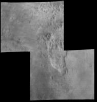
Mariner 6 Mosaics.
I have reprocessed the mosaics from Mariner-6. I reconstructed the frames based on both the analog and the digital transmissions of the image. The analog images were filtered to enhance the visibility of topography, wiping out brightness information. The digital images were in 7-bit form and only a fraction of the pixels were transmitted, but they contain proper brightness information. A set of images combining the two was constructed at the time, but there is definitely some loss of detail. Working in 16 bit, I can do a better job. I also worked to remove after-images. Another problem is that the wide angle camera that took these mosaics cycled through filters but did not take the images on top of each other for color combination. Rather, the filters were simply included to test the photographic properties for color studies on future missions (although Mariner-7 did some color work). As a result, I had to modify the mosaics so that the frames would cosmetically match. Far encounter (last two frames).
Mosaic 1
Mosaic 2 and 3. These overlapped. Also, there was a small gore between the two mosaics. I filled it in with Mariner 7 near encounter data.
Narrow angle. Narrow angle frames 6 and 14 happened to slightly overlap, allowing the one narrow angle mosaic to be made.
I am now working on Mariner 7 mosaics. There are more Mariner 7 images, and due to some issues with the digital versions of them, they are proving quite difficult. I hope to post them soon. I also hope to further clean up the Mariner 6 frames and mosaics. -------------------- |
||||
 |
 
|
||||
|
Aug 4 2008, 09:45 PM
Post
#2
|
|
|
Merciless Robot Group: Admin Posts: 8784 Joined: 8-December 05 From: Los Angeles Member No.: 602 |
Very nice indeed, Ted!!!
Makes me wonder how the former 'lunar' stereotype of Mars persisted after M6 & M7. Craters, sure, but certainly some pretty broad hints of far more diverse landforms. -------------------- A few will take this knowledge and use this power of a dream realized as a force for change, an impetus for further discovery to make less ancient dreams real.
|
|
|
|
|
Aug 5 2008, 04:18 AM
Post
#3
|
|
|
Interplanetary Dumpster Diver Group: Admin Posts: 4404 Joined: 17-February 04 From: Powell, TN Member No.: 33 |
A lot of the terrain was referred to as "chaotic terrain." They realized there was something else there, but they couldn't figure out what.
-------------------- |
|
|
|
|
Aug 5 2008, 04:51 AM
Post
#4
|
|
 Senior Member Group: Members Posts: 3419 Joined: 9-February 04 From: Minneapolis, MN, USA Member No.: 15 |
Most of what was named "chaotic terrain" ended up being large areas that seem to have had groundwater sapped out from under them. Most all of these landforms are at the heads of the catastrophic flood channels. It's consistent with large masses of groundwater being suddenly released (possibly by the breaking of ice dams) -- the lands that covered the huge aquifers collapsed, and the lands downstream of the massive water release were scored and flattened by the floods, with characteristic teardrop-shaped "islands" being carved by water passing to the sides of areographic high points.
So, yeah -- they're not "exotic chaos features," they're understandable and recognizable (if very large) collapse features. -the other Doug -------------------- The trouble ain't that there is too many fools, but that the lightning ain't distributed right. -Mark Twain
|
|
|
|
|
Aug 5 2008, 06:05 PM
Post
#5
|
||
|
Interplanetary Dumpster Diver Group: Admin Posts: 4404 Joined: 17-February 04 From: Powell, TN Member No.: 33 |
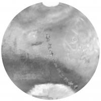
Some were from sapping, but other "chaotic" areas were from sapping, but others, most notably in the poorer quality images, were channels that couldn't be fully interpreted.
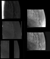
Here is an example of what the images are like, using frame 6N3. In the left hand column, the top image is the analog transmission. The image below it is the real time digital transmission. The last image is the digital image recorded on the tape recorder. One in every seven columns was recorded on the tape recorder, while one in 28 columns was transmitted in real time. The real time set is useful in that it fills in the jail-bar that was not recorded on the digital tape recorder. In the right hand column, the top image is the combined version created by the project. The lower one is my version. The after image clearly visible is frame 6N1. When I subtracted my reconstructed version of that frame, it helped alot. For the record, in attempting to quasi-flat field the image, the dark spot visible in the project images but not in mine to the left of center of the frame was removed (it is a camera defect that appears in every image).
-------------------- |
|
|
|
|
|
|
Aug 8 2008, 07:16 PM
Post
#6
|
|||
|
Interplanetary Dumpster Diver Group: Admin Posts: 4404 Joined: 17-February 04 From: Powell, TN Member No.: 33 |
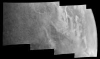
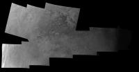
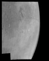
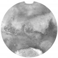
Here are the first mosaics. There is no mosaic 2 because it is not complete.
Mosaic 1:
Mosaic 3:
-------------------- |
||
|
|
|
||
|
Aug 8 2008, 09:42 PM
Post
#7
|
|
|
Solar System Cartographer Group: Members Posts: 10166 Joined: 5-April 05 From: Canada Member No.: 227 |
As usual, fantastic work, Ted. The Mariner 6 'mosaics 2 and 3' composite includes the Opportunity landing site - Ithaca crater is just visible as a dark spot. I'll try to post an annotated version later.
Phil -------------------- ... because the Solar System ain't gonna map itself.
Also to be found posting similar content on https://mastodon.social/@PhilStooke Maps for download (free PD: https://upload.wikimedia.org/wikipedia/comm...Cartography.pdf NOTE: everything created by me which I post on UMSF is considered to be in the public domain (NOT CC, public domain) |
|
|
|
|
Aug 8 2008, 09:54 PM
Post
#8
|
|
|
Interplanetary Dumpster Diver Group: Admin Posts: 4404 Joined: 17-February 04 From: Powell, TN Member No.: 33 |
I replaced it with a better 8-bit conversion. I also fixed some defects that I hadn't noticed before.
-------------------- |
|
|
|
|
Sep 19 2008, 08:30 PM
Post
#9
|
|
|
Member Group: Members Posts: 206 Joined: 15-August 07 From: Shrewsbury, Shropshire Member No.: 3233 |
QUOTE (Phil Stooke @ Aug 8 2008, 10:42 PM)  As usual, fantastic work, Ted. The Mariner 6 'mosaics 2 and 3' composite includes the Opportunity landing site - Ithaca crater is just visible as a dark spot. I'll try to post an annotated version later. Phil Now that Opportunity is going to Ithaca/ Endeavour crater is there any chance of you posting the annotated version? If Endeavour crater is so large that it could be seen on a 1960s Mars fly by then Opportunity's view from Endeavour's rim is going to be truly spectacular. |
|
|
|
|
Sep 19 2008, 09:19 PM
Post
#10
|
||
|
Solar System Cartographer Group: Members Posts: 10166 Joined: 5-April 05 From: Canada Member No.: 227 |
Sorry! I forgot.
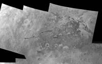
Here is an excerpt from Ted's image with Endeavour (Ithaca) appearing as a dark spot. I also labelled the potential MSL site Miyamoto, now heavily downgraded in the voting. Phil
-------------------- ... because the Solar System ain't gonna map itself.
Also to be found posting similar content on https://mastodon.social/@PhilStooke Maps for download (free PD: https://upload.wikimedia.org/wikipedia/comm...Cartography.pdf NOTE: everything created by me which I post on UMSF is considered to be in the public domain (NOT CC, public domain) |
|
|
|
|
|
|
Sep 19 2008, 09:29 PM
Post
#11
|
|
|
Member Group: Members Posts: 206 Joined: 15-August 07 From: Shrewsbury, Shropshire Member No.: 3233 |
QUOTE (Phil Stooke @ Sep 19 2008, 10:19 PM) Sorry! I forgot. Here is an excerpt from Ted's image with Endeavour (Ithaca) appearing as a dark spot. I also labelled the potential MSL site Miyamoto, now heavily downgraded in the voting. Phil Thanks a lot. It looks like there are some even bigger craters to visit after Endeavour 
|
|
|
|
|
Sep 19 2008, 10:20 PM
Post
#12
|
|
 Administrator Group: Admin Posts: 5172 Joined: 4-August 05 From: Pasadena, CA, USA, Earth Member No.: 454 |
Oh, my. That one went straight to the blog.
--Emily -------------------- My website - My Patreon - @elakdawalla on Twitter - Please support unmannedspaceflight.com by donating here.
|
|
|
|
|
Sep 19 2008, 10:49 PM
Post
#13
|
|
|
Interplanetary Dumpster Diver Group: Admin Posts: 4404 Joined: 17-February 04 From: Powell, TN Member No.: 33 |
Unfortunately, it is in one of the worst frames, but still, wow! Good find Phil!
-------------------- |
|
|
|
|
Feb 14 2012, 01:58 AM
Post
#14
|
||
|
Interplanetary Dumpster Diver Group: Admin Posts: 4404 Joined: 17-February 04 From: Powell, TN Member No.: 33 |
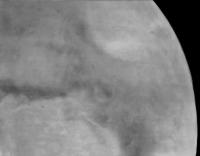
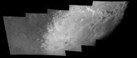
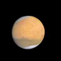
This isn't exactly a mosaic, but I have been working with the Mariner 7 far encounter data again. You can read about it here. This is the best result I've gotten so far.
-------------------- |
|
|
|
|
|
|
Feb 15 2012, 03:16 PM
Post
#15
|
|
 Senior Member Group: Members Posts: 1088 Joined: 19-February 05 From: Close to Meudon Observatory in France Member No.: 172 |
QUOTE (tedstryk @ Feb 14 2012, 02:58 AM) This isn't exactly a mosaic, but I have been working with the Mariner 7 far encounter data again. You can read about it here. This is the best result I've gotten so far. ...and this is also the "romantic" mysterious red planet of the 60's, we were all dreaming about when we were young. Beautiful ! Thanks a lot Tedstryk 
|
|
|
|
|
Sep 4 2013, 03:33 AM
Post
#16
|
|
|
Senior Member Group: Members Posts: 2517 Joined: 13-September 05 Member No.: 497 |
QUOTE (tedstryk @ Aug 4 2008, 01:56 PM) The digital images were in 7-bit form and only a fraction of the pixels were transmitted... Sorry to resurrect this thread, but it was linked in Emily's blog posting on Bruce Murray and early Mariner images, see http://www.planetary.org/blogs/emily-lakda...ner-images.html The statement about only a fraction of the pixels being transmitted is not completely accurate: see http://mars.jpl.nasa.gov/mgs/msss/camera/i..._2_00_vishniac/ and http://mars.jpl.nasa.gov/mgs/msss/camera/i...m7_imaging.html for a description of how the MM69 camera system worked. All of the pixels were transmitted, but some only in analog AC form. As for "Murray's stubborn insistence that it would be ludicrous to send a spacecraft to Mars and not include a camera", NASA is of course just about to do that with MAVEN. The PI even speaks with pride (see http://www.aviationweek.com/Article.aspx?i...759.xml&p=2 ) about his resistance to "science creep", even though AFAIK the mission cost a fairly large fraction of the total cost of MRO -- $671M for MAVEN, $720M for MRO. Disclaimer: being a camera designer I obviously have some bias. -------------------- Disclaimer: This post is based on public information only. Any opinions are my own.
|
|
|
|
|
Sep 4 2013, 09:42 AM
Post
#17
|
|
|
Interplanetary Dumpster Diver Group: Admin Posts: 4404 Joined: 17-February 04 From: Powell, TN Member No.: 33 |
For the color approach sequence, there was no analog transmission. Just the limited digital data. The tape recorder was being saved for near encounter.
-------------------- |
|
|
|
|
Sep 4 2013, 04:11 PM
Post
#18
|
|
|
Senior Member Group: Members Posts: 2517 Joined: 13-September 05 Member No.: 497 |
QUOTE (tedstryk @ Sep 4 2013, 02:42 AM) For the color approach sequence, there was no analog transmission... The tape recorder was being saved for near encounter. You're right for this sequence (obviously you've worked with this dataset more than I have), but as you note on your web site, some of the far-encounter images were transmitted in full-res analog. See http://archive.org/stream/nasa_techdoc_197...e/n294/mode/1up -------------------- Disclaimer: This post is based on public information only. Any opinions are my own.
|
|
|
|
|
Aug 26 2022, 11:50 PM
Post
#19
|
|
|
Member Group: Members Posts: 411 Joined: 18-September 17 Member No.: 8250 |
While looking into Mariner 6/7 image processing today, came across a
2020 PDART (Planetary Data Archiving, Restoration, and Tools) project to restore and archive in PDS Mariner 6/7 images and SPICE kernels. PDS Archive Directory: https://pds-geosciences.wustl.edu/mariner/m...rt14_mariner69/ PDF description of PDART work: https://pds-geosciences.wustl.edu/mariner/m...le_overview.pdf |
|
|
|
|
Sep 9 2022, 10:55 PM
Post
#20
|
||
|
Solar System Cartographer Group: Members Posts: 10166 Joined: 5-April 05 From: Canada Member No.: 227 |
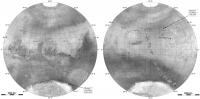
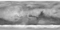
This is a good opportunity to post this - the sum of all imaging by Mariners 4, 6 and 7. The background map is a mosaic of far encounter images from 6 and 7, and the superimposed Mariner 4 and the 6 and 7 near encounter images show everything that was known about the planet's surface until Mariner 9 arrived in 1971. The white patch in the north was not visible to the 6 and 7 missions. I am not counting the Mars 3 orbiter images which are not really very useful.
Phil
-------------------- ... because the Solar System ain't gonna map itself.
Also to be found posting similar content on https://mastodon.social/@PhilStooke Maps for download (free PD: https://upload.wikimedia.org/wikipedia/comm...Cartography.pdf NOTE: everything created by me which I post on UMSF is considered to be in the public domain (NOT CC, public domain) |
|
|
|
|
|
|
Sep 11 2022, 03:42 AM
Post
#21
|
|
 Member Group: Members Posts: 227 Joined: 13-October 09 From: Olympus Mons Member No.: 4972 |
This is neat! Do you by chance have a cylindrical version without grid lines and labels? Would like to use it in the program Celestia as part of a series of Mars textures showing how the Red Planet has changed over the decades.
-------------------- "Thats no moon... IT'S A TRAP!"
|
|
|
|
|
Sep 11 2022, 07:10 AM
Post
#22
|
|
|
Solar System Cartographer Group: Members Posts: 10166 Joined: 5-April 05 From: Canada Member No.: 227 |
I don't have a version with the near encounter images in cylindrical projection but I do have the background maps for both Mariner 6 and 7. I will dig them out.
Phil -------------------- ... because the Solar System ain't gonna map itself.
Also to be found posting similar content on https://mastodon.social/@PhilStooke Maps for download (free PD: https://upload.wikimedia.org/wikipedia/comm...Cartography.pdf NOTE: everything created by me which I post on UMSF is considered to be in the public domain (NOT CC, public domain) |
|
|
|
|
Oct 22 2022, 01:53 PM
Post
#23
|
|
|
Member Group: Members Posts: 227 Joined: 13-October 09 From: Olympus Mons Member No.: 4972 |
Do you plan to make a combination of Mariner 4, 6 and 7 in the future with near and far?
-------------------- "Thats no moon... IT'S A TRAP!"
|
|
|
|
|
Oct 23 2022, 07:08 AM
Post
#24
|
|
|
Solar System Cartographer Group: Members Posts: 10166 Joined: 5-April 05 From: Canada Member No.: 227 |
The composite was made in the azimuthal projections. I don't have time to project to cylindrical. Only the far-encounter bases were done in cylindrical projection. I will dig them out when i can.
Phil -------------------- ... because the Solar System ain't gonna map itself.
Also to be found posting similar content on https://mastodon.social/@PhilStooke Maps for download (free PD: https://upload.wikimedia.org/wikipedia/comm...Cartography.pdf NOTE: everything created by me which I post on UMSF is considered to be in the public domain (NOT CC, public domain) |
|
|
|
|
Jan 8 2023, 03:38 PM
Post
#25
|
|
|
Member Group: Members Posts: 227 Joined: 13-October 09 From: Olympus Mons Member No.: 4972 |
QUOTE (Phil Stooke @ Sep 11 2022, 02:10 AM) I don't have a version with the near encounter images in cylindrical projection but I do have the background maps for both Mariner 6 and 7. I will dig them out. Phil I am interested, could you post a full resolution version without the grids or labels of the near and far encounter stuff of 4 6 and 7? I would like to see if I can reproject them to equirectangular and use them for an addon for Celestia showing the changes of Mars overtime starting with the late 60's. -------------------- "Thats no moon... IT'S A TRAP!"
|
|
|
|
|
Jan 9 2023, 05:28 PM
Post
#26
|
|
|
Solar System Cartographer Group: Members Posts: 10166 Joined: 5-April 05 From: Canada Member No.: 227 |
I will find those flies.
Phil -------------------- ... because the Solar System ain't gonna map itself.
Also to be found posting similar content on https://mastodon.social/@PhilStooke Maps for download (free PD: https://upload.wikimedia.org/wikipedia/comm...Cartography.pdf NOTE: everything created by me which I post on UMSF is considered to be in the public domain (NOT CC, public domain) |
|
|
|
|
Jan 31 2023, 10:51 PM
Post
#27
|
|
|
Member Group: Members Posts: 227 Joined: 13-October 09 From: Olympus Mons Member No.: 4972 |
Did you ever find the gridless near and far encounter maps?
-------------------- "Thats no moon... IT'S A TRAP!"
|
|
|
|
|
Feb 3 2023, 06:19 PM
Post
#28
|
|||
|
Solar System Cartographer Group: Members Posts: 10166 Joined: 5-April 05 From: Canada Member No.: 227 |
Yes. Here they are. Mariners 4, 6 and 7 combined. The projection is Azimuthal Equidistant.
Phil
-------------------- ... because the Solar System ain't gonna map itself.
Also to be found posting similar content on https://mastodon.social/@PhilStooke Maps for download (free PD: https://upload.wikimedia.org/wikipedia/comm...Cartography.pdf NOTE: everything created by me which I post on UMSF is considered to be in the public domain (NOT CC, public domain) |
||
|
|
|
||
|
Feb 4 2023, 06:55 AM
Post
#29
|
|
|
Senior Member Group: Members Posts: 1088 Joined: 19-February 05 From: Close to Meudon Observatory in France Member No.: 172 |
QUOTE (Phil Stooke @ Feb 3 2023, 07:19 PM) Yes. Here they are. Mariners 4, 6 and 7 combined. The projection is Azimuthal Equidistant. Phil What a nice work! Thank you very much Phil
|
|
|
|
|
Feb 9 2023, 02:48 PM
Post
#30
|
||
|
Member Group: Members Posts: 227 Joined: 13-October 09 From: Olympus Mons Member No.: 4972 |
I managed to reproject these and with slight touchups, incorporate them into the far encounter imagery with an Earth-based map covering the north polar region. I then adjusted the contrast of the near encounter images to produce this map showing our knowledge of Mars at the end of the 60's. Because of the major dust storm in 71, the albedo features of Mars changed permanently.
Attached thumbnail(s)
-------------------- "Thats no moon... IT'S A TRAP!"
|
|
|
|
|
|
|
Feb 10 2023, 12:00 AM
Post
#31
|
|
|
Solar System Cartographer Group: Members Posts: 10166 Joined: 5-April 05 From: Canada Member No.: 227 |
Very nice!
On my originals and on this projection of them you may notice faint streaks near the north pole which look like the fabled canals of Mars. They are canals... as portrayed on the old ACIC Mars Chart MEC-1 published in 1965. Some sources show an incorrect date of 1962, which is the date the material for the background drawing was collected. For my first Mars book I prepared a chronological series of Mars global maps. The ACIC map was scanned and the names and grid removed digitally. The polar sections were shown as several orthographic drawings but by an immense amount of wizardry their polar sections were combined and reprojected to create the big cylindrical map which then became my two hemispheres. Then it was time to add the Mariner images. Mariners 6 and 7 arrived when the south pole was illuminated and turned towards the spacecraft, so the north pole was not seen. I projected the far encounter images to make a global map up to about 60 north. The north polar area came from the previous map in the sequence. Only with Mariner 9 did that get replaced. Phil -------------------- ... because the Solar System ain't gonna map itself.
Also to be found posting similar content on https://mastodon.social/@PhilStooke Maps for download (free PD: https://upload.wikimedia.org/wikipedia/comm...Cartography.pdf NOTE: everything created by me which I post on UMSF is considered to be in the public domain (NOT CC, public domain) |
|
|
|
|
Feb 10 2023, 11:01 PM
Post
#32
|
|
|
Member Group: Members Posts: 227 Joined: 13-October 09 From: Olympus Mons Member No.: 4972 |
For the far encounter, I noticed you used only Mariner 7 in that but I noticed some areas particularly Malea Planum where 6 had better imagery so I used that there.
-------------------- "Thats no moon... IT'S A TRAP!"
|
|
|
|
|

|
Lo-Fi Version | Time is now: 23rd May 2024 - 07:35 AM |
|
RULES AND GUIDELINES Please read the Forum Rules and Guidelines before posting. IMAGE COPYRIGHT |
OPINIONS AND MODERATION Opinions expressed on UnmannedSpaceflight.com are those of the individual posters and do not necessarily reflect the opinions of UnmannedSpaceflight.com or The Planetary Society. The all-volunteer UnmannedSpaceflight.com moderation team is wholly independent of The Planetary Society. The Planetary Society has no influence over decisions made by the UnmannedSpaceflight.com moderators. |
SUPPORT THE FORUM Unmannedspaceflight.com is funded by the Planetary Society. Please consider supporting our work and many other projects by donating to the Society or becoming a member. |
|